欢迎访问《中国农学通报》,
中国农学通报 ›› 2023, Vol. 39 ›› Issue (4): 69-75.doi: 10.11924/j.issn.1000-6850.casb2022-0116
颜杰( ), 谷海斌, 武红旗, 张丽, 颜安, 盛建东()
收稿日期:2022-03-02
修回日期:2022-05-19
出版日期:2023-02-05
发布日期:2023-01-31
通讯作者:
盛建东,男,1970年出生,甘肃秦安人,教授,博士,主要从事土壤空间变异与数字制图、养分资源高效利用研究。通信地址:830052 新疆乌鲁木齐市沙依巴克区八一街道农大东路311号 新疆农业大学,Tel:0991-8763937,E-mail:sjd@xjau.edu.cn。
作者简介:颜杰,男,1995年出生,贵州纳雍人,硕士研究生,研究方向:盐渍化土壤改良研究。通信地址:830052 新疆乌鲁木齐市沙依巴克区八一街道农大东路311号 新疆农业大学,E-mail:508244181@qq.com。
基金资助:
YAN Jie(), GU Haibin, WU Hongqi, ZHANG Li, YAN An, SHENG Jiandong()
Received:2022-03-02
Revised:2022-05-19
Online:2023-02-05
Published:2023-01-31
摘要:
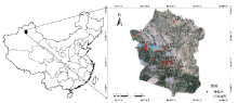
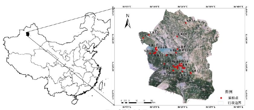
大地电导率仪(EM38)是快速无损测定土壤盐分的有效方法。为建立新疆农田土壤EM38测试值与土壤盐分关系模型,以新疆玛纳斯县农田土壤为研究对象,利用EM38在野外实地测定土壤表观电导率,并挖掘土壤剖面进行分层采样,室内测定土壤盐分含量,据此构建基于EM38的土壤盐分解译模型。结果表明:(1)利用土壤实测盐分和EM38电导率数据,分别建立不同土壤深度下EM38垂直模式和水平模式以及两者联用的二元线性回归土壤盐分解译模型。(2)3种EM38盐分解译模型的R2随着土壤深度增加而增加,并且在土壤深度小于20 cm时,垂直模式的解译精度大于水平模式,深度大于20 cm后,解译精度则刚好与之相反。(3)二元线性回归模型的解译精度明显优于一元线性回归模型。本研究所构建的EM38土壤盐分解译模型,将为绿洲农田土壤盐分快速调查和动态监测提供可靠的反演参数和模型。
颜杰, 谷海斌, 武红旗, 张丽, 颜安, 盛建东. 基于EM38的玛纳斯县土壤剖面盐分的解译模型构建[J]. 中国农学通报, 2023, 39(4): 69-75.
YAN Jie, GU Haibin, WU Hongqi, ZHANG Li, YAN An, SHENG Jiandong. Modeling of Soil Salinity Interpretation in Manas County Based on EM38[J]. Chinese Agricultural Science Bulletin, 2023, 39(4): 69-75.
| 土层/cm | 最小值/(g/kg) | 最大值/(g/kg) | 均值/(g/kg) | 变异系数/% | 深度/cm | 最小值/(g/kg) | 最大值/(g/kg) | 均值/(g/kg) | 变异系数/% |
|---|---|---|---|---|---|---|---|---|---|
| 0~10 | 0.02 | 36.73 | 6.41 | 121 | 0~10 | 0.02 | 36.73 | 6.41 | 121 |
| 10~20 | 0.05 | 31.04 | 5.72 | 109 | 0~20 | 0.04 | 28.72 | 6.08 | 111 |
| 20~30 | 0.08 | 37.57 | 5.68 | 109 | 0~30 | 0.13 | 31.43 | 5.91 | 107 |
| 30~40 | 0.08 | 43.62 | 6.19 | 113 | 0~40 | 0.14 | 34.48 | 6.00 | 106 |
| 40~50 | 0.08 | 38.66 | 6.21 | 111 | 0~50 | 0.22 | 35.15 | 5.99 | 105 |
| 50~60 | 0.00 | 42.50 | 6.66 | 116 | 0~60 | 0.25 | 38.61 | 6.11 | 104 |
| 60~70 | 0.01 | 51.20 | 6.55 | 117 | 0~70 | 0.30 | 38.61 | 6.17 | 105 |
| 70~80 | 0.00 | 41.95 | 6.53 | 115 | 0~80 | 0.30 | 39.03 | 6.20 | 106 |
| 80~90 | 0.02 | 44.74 | 6.65 | 118 | 0~90 | 0.34 | 39.66 | 6.26 | 106 |
| 90~100 | 0.02 | 41.34 | 6.68 | 112 | 0~100 | 0.52 | 39.83 | 6.43 | 104 |
| 深度/cm | 最小值/(mS/m) | 最大值/(mS/m) | 平均值/(mS/m) | 标准差/(mS/m) | 变异系数/% | |||||||||
|---|---|---|---|---|---|---|---|---|---|---|---|---|---|---|
| EMh | EMv | EMh | EMv | EMh | EMv | EMh | EMv | EMh | EMv | |||||
| 0~10 | 1.77 | 4.06 | 644.69 | 292.42 | 108.17 | 92.10 | 107.59 | 63.32 | 99 | 69 | ||||
| 0~20 | 4.57 | 4.43 | 299.07 | 332.19 | 81.85 | 95.94 | 67.11 | 70.77 | 82 | 74 | ||||
| 0~30 | 4.71 | 0.54 | 360.87 | 377.93 | 87.82 | 103.78 | 75.57 | 81.24 | 86 | 78 | ||||
| 0~40 | 1.83 | 5.23 | 429.31 | 441.33 | 102.45 | 117.55 | 92.32 | 89.64 | 90 | 76 | ||||
| 0~50 | 6.95 | 0.67 | 530.20 | 504.77 | 122.99 | 132.55 | 114.30 | 103.77 | 93 | 78 | ||||
| 0~60 | 1.40 | 1.18 | 660.28 | 569.61 | 146.91 | 150.77 | 138.43 | 117.86 | 94 | 78 | ||||
| 0~70 | 6.52 | 8.52 | 798.84 | 654.96 | 176.91 | 170.50 | 173.14 | 134.81 | 98 | 79 | ||||
| 0~80 | 8.40 | 742.03 | 191.80 | 152.28 | 79 | |||||||||
| 0~90 | 9.46 | 831.10 | 213.38 | 170.75 | 80 | |||||||||
| 0~100 | 9.18 | 856.02 | 234.18 | 188.29 | 80 | |||||||||
| 0~10 cm | 0~20 cm | 0~30 cm | 0~40 cm | 0~50 cm | 0~60 cm | 0~70 cm | 0~80 cm | 0~90 cm | 0~100 cm | |
|---|---|---|---|---|---|---|---|---|---|---|
| EMv | 0.568** | 0.612** | 0.631** | 0.627** | 0.690** | 0.714** | 0.723** | 0.730** | 0.738** | 0.751** |
| EMh | 0.208* | 0.568** | 0.690** | 0.719** | 0.731** | 0.742** | 0.749** |
| 深度/cm | y=aEMv+b | y=aEMh+b | |||||||
|---|---|---|---|---|---|---|---|---|---|
| a | b | R2 | P | a | b | R2 | P | ||
| 0~10 | 0.067 | 0.409 | 0.324 | 0.000 | 0.034 | 3.409 | 0.112 | 0.002 | |
| 0~20 | 0.057 | 0.759 | 0.375 | 0.000 | 0.050 | 2.083 | 0.254 | 0.000 | |
| 0~30 | 0.047 | 1.102 | 0.396 | 0.000 | 0.056 | 1.343 | 0.430 | 0.000 | |
| 0~40 | 0.043 | 1.117 | 0.380 | 0.000 | 0.049 | 1.391 | 0.486 | 0.000 | |
| 0~50 | 0.040 | 0.789 | 0.473 | 0.000 | 0.041 | 1.492 | 0.508 | 0.000 | |
| 0~60 | 0.038 | 0.574 | 0.505 | 0.000 | 0.035 | 1.481 | 0.529 | 0.000 | |
| 0~70 | 0.034 | 0.543 | 0.515 | 0.000 | 0.030 | 1.504 | 0.545 | 0.000 | |
| 0~80 | 0.031 | 0.462 | 0.532 | 0.000 | |||||
| 0~90 | 0.029 | 0.420 | 0.546 | 0.000 | |||||
| 0~100 | 0.026 | 0.465 | 0.536 | 0.000 | |||||
| 深度/cm | y=aEMv+bEMh+c | ||||
|---|---|---|---|---|---|
| a | b | c | R2 | P | |
| 0~10 | 0.071 | -0.004 | 0.354 | 0.327 | 0.000 |
| 0~20 | 0.062 | -0.005 | 0.597 | 0.379 | 0.000 |
| 0~30 | 0.006 | 0.050 | 1.237 | 0.431 | 0.000 |
| 0~40 | -0.029 | 0.077 | 2.167 | 0.505 | 0.000 |
| 0~50 | 0.002 | 0.039 | 1.445 | 0.508 | 0.000 |
| 0~60 | 0.009 | 0.027 | 1.159 | 0.532 | 0.000 |
| 0~70 | 0.008 | 0.023 | 1.187 | 0.548 | 0.000 |
| 深度/cm | y=aEMv+b | y=aEMh+b | |||||
|---|---|---|---|---|---|---|---|
| R2 | P | RMSE | R2 | P | RMSE | ||
| 0~10 | 0.314 | 0.030 | 0.534 | 0.552 | 0.001 | 0.820 | |
| 0~20 | 0.396 | 0.012 | 0.461 | 0.665 | 0.000 | 0.362 | |
| 0~30 | 0.448 | 0.006 | 0.454 | 0.687 | 0.000 | 0.259 | |
| 0~40 | 0.482 | 0.004 | 0.410 | 0.694 | 0.000 | 0.228 | |
| 0~50 | 0.524 | 0.002 | 0.354 | 0.705 | 0.000 | 0.197 | |
| 0~60 | 0.563 | 0.001 | 0.299 | 0.741 | 0.000 | 0.174 | |
| 0~70 | 0.604 | 0.001 | 0.282 | 0.737 | 0.000 | 0.155 | |
| 0~80 | 0.598 | 0.001 | 0.277 | ||||
| 0~90 | 0.605 | 0.001 | 0.261 | ||||
| 0~100 | 0.756 | 0.000 | 0.197 | ||||
| 深度/cm | R2 | P | RMSE |
|---|---|---|---|
| 0~10 | 0.288 | 0.039 | 0.533 |
| 0~20 | 0.358 | 0.019 | 0.468 |
| 0~30 | 0.681 | 0.000 | 0.268 |
| 0~40 | 0.686 | 0.000 | 0.198 |
| 0~50 | 0.703 | 0.000 | 0.201 |
| 0~60 | 0.723 | 0.000 | 0.191 |
| 0~70 | 0.727 | 0.000 | 0.172 |
| 深度/cm | R2 | P | RMSE |
|---|---|---|---|
| 0~10 | 0.288 | 0.039 | 0.533 |
| 0~20 | 0.358 | 0.019 | 0.468 |
| 0~30 | 0.681 | 0.000 | 0.268 |
| 0~40 | 0.686 | 0.000 | 0.198 |
| 0~50 | 0.703 | 0.000 | 0.201 |
| 0~60 | 0.723 | 0.000 | 0.191 |
| 0~70 | 0.727 | 0.000 | 0.172 |
| 深度/cm | 盐分未进行加权平均的模型的R2 | 深度/cm | 对盐分进行加权平均后的模型的R2 | ||||
|---|---|---|---|---|---|---|---|
| EMv | EMh | EMv+EMh | EMv | EMh | EMv+EMh | ||
| 0~10 | 0.324*** | 0.112** | 0.327*** | 0~10 | 0.324*** | 0.112** | 0.327*** |
| 10~20 | 0.318*** | 0.201*** | 0.318*** | 0~20 | 0.375*** | 0.254*** | 0.379*** |
| 20~30 | 0.340*** | 0.340*** | 0.345*** | 0~30 | 0.396*** | 0.430*** | 0.431*** |
| 30~40 | 0.364*** | 0.486*** | 0.523*** | 0~40 | 0.380*** | 0.486*** | 0.505*** |
| 40~50 | 0.422*** | 0.417*** | 0.421*** | 0~50 | 0.473*** | 0.508*** | 0.508*** |
| 50~60 | 0.514*** | 0.488*** | 0.510*** | 0~60 | 0.505*** | 0.529*** | 0.532*** |
| 60~70 | 0.430*** | 0.379*** | 0.420*** | 0~70 | 0.515*** | 0.545*** | 0.548*** |
| 70~80 | 0.526*** | 0~80 | 0.532*** | ||||
| 80~90 | 0.521*** | 0~90 | 0.546*** | ||||
| 90~100 | 0.506*** | 0~100 | 0.536*** | ||||
| 深度/cm | Model-DK(邓凯) | y=aEMv+bEMh+c(本研究) | |||
|---|---|---|---|---|---|
| R2 | P | R2 | P | ||
| 0~10 | 0.185 | 0.110 | 0.288 | 0.039 | |
| 0~20 | 0.263 | 0.050 | 0.358 | 0.019 | |
| 0~40 | 0.396 | 0.012 | 0.686 | 0.000 | |
| 0~60 | 0.539 | 0.002 | 0.723 | 0.000 | |
| 0~70 | 0.548 | 0.002 | 0.727 | 0.000 | |
| [1] |
史晓艳, 李维弟, 余露, 等. 玛纳斯河流域农灌区土壤盐渍化遥感定量评价[J]. 灌溉排水学报, 2018, 37(11):69-75,83.
|
| [2] |
张鹏辉, 侯宪东, 王健. 新疆地区盐碱地成因及治理措施[J]. 现代农业科技, 2017(24):178-180.
|
| [3] |
姚远, 丁建丽, 张芳, 等. 基于电磁感应技术的塔里木盆地北缘绿洲土壤盐分空间变异特性[J]. 中国沙漠, 2014, 34(3):765-772.
|
| [4] |
陈玉娟. EM38大地电导仪的应用研究[J]. 干旱地区农业研究, 2004, 22(2):146-148.
|
| [5] |
刘广明, 杨劲松, 鞠茂森, 等. 电磁感应土地测量技术及其在农业领域的应用[J]. 土壤, 2003, 35(1):27-29.
|
| [6] |
姚荣江, 杨劲松, 刘广明. EM38在黄河三角洲地区土壤盐渍化快速检测中的应用研究[J]. 干旱地区农业研究, 2008, 26(1):67-73.
|
| [7] |
doi: 10.1111/j.1475-2743.2011.00386.x URL |
| [8] |
李海涛, 李小梅,
|
| [9] |
吴亚坤, 杨劲松, 刘广明. 基于遥感与电磁感应仪数据的土壤盐分空间变异性[J]. 农业工程学报, 2009, 25(7):148-152.
|
| [10] |
夏英辉, 熊黑钢. 土壤中盐分含量对EM38大地电导仪测量精度的影响分析[J]. 干旱区资源与环境, 2013, 27(10):163-168.
|
| [11] |
李晓明, 杨劲松, 刘梅先, 等. 基于电磁感应的典型干旱区土壤盐分空间异质性[J]. 农业工程学报, 2010, 26(12):97-101.
|
| [12] |
赵军伟, 蒋平安, 盛建东, 等. EM38电磁发生仪测定结果的影响因素分析[J]. 干旱区地理, 2005, 28(3):362-366.
|
| [13] |
doi: 10.1016/j.geodrs.2016.04.006 URL |
| [14] |
doi: 10.1111/ejss.12278 URL |
| [15] |
张同娟, 杨劲松, 刘广明, 等. 基于电磁感应仪的河口地区底聚型盐分剖面特征的解译[J]. 农业工程学报, 2009, 25(11):109-113.
|
| [16] |
姚荣江, 杨劲松, 刘广明, 等. 电磁感应仪EM38用于土壤盐渍剖面分类与评价研究[J]. 中国地质灾害与防治学报, 2007, 18(4):54-59.
|
| [17] |
李兵, 刘广明, 苏里坦, 等. 基于磁感式大地电导率仪的土壤盐分解译模型[J]. 土壤, 2017, 49(4):789-794.
|
| [18] |
李洪义, 史舟, 吴次芳, 等. 基于EM38的滨海盐土剖面电导率原位测定[J]. 土壤学报, 2013, 50(6):1231-1235.
|
| [19] |
doi: 10.1007/s11119-011-9253-2 URL |
| [20] |
宋江辉, 朱永琪, 陈建华, 等. 基于电磁感应仪的土壤盐渍化剖面特征解译研究[J]. 土壤通报, 2017, 48(3):552-559.
|
| [21] |
李晓明, 杨劲松, 刘广明. 基于电磁感应的不同膜灌模式下棉田土壤盐分分布研究[J]. 中国生态农业学报, 2011, 19(2):235-239.
|
| [22] |
邓煜霖. 基于EM38-MK2干旱区薄膜覆盖棉田土壤剖面电导率解译研究[D]. 乌鲁木齐: 新疆大学, 2015.
|
| [23] |
鲍士旦. 土壤农化分析[M]. 北京: 中国农业出版社, 2000:183-210.
|
| [24] |
李淑敏, 李红, 周连第. 土壤电导率的快速测量(EM38)与数据的研究应用[J]. 安徽农业科学, 2009, 37(29):14001-14004,14015.
|
| [25] |
张同娟, 杨劲松, 刘广明. 基于EM38长江河口地区土壤盐渍化特征研究[J]. 水土保持学报, 2009, 23(6):210-214.
|
| [26] |
张为政, 殷立娟. 电磁感应电导仪(EM38)测定土壤含盐量的研究[J]. 应用生态学报, 1993, 4(3):289-294.
|
| [27] |
新疆维吾尔自治区农业厅. 新疆土壤[M]. 北京: 科学出版社,1996.
|
| [28] |
王海江. 玛纳斯河流域土壤盐渍化过程和格局特征及盐渍土改良模式探讨[D]. 北京: 中国农业大学, 2014.
|
| [29] |
姚远. 干湿季节下基于遥感和电磁感应技术的绿洲土壤盐渍化评估与尺度效应分析[D]. 乌鲁木齐: 新疆大学, 2013.
|
| [30] |
郑丽丽, 熊黑钢, 闫人华, 等. 基于逐步回归模型和EM38电磁感应分析的干旱区人工水库区域土壤盐分测定——以新疆八户地水库为例[J]. 甘肃农业大学学报, 2013, 48(3):74-81.
|
| [31] |
乔江飞. 基于EM38的盐渍化土壤剖面盐分监测研究[D]. 石河子: 石河子大学, 2016.
|
| [32] |
邓凯, 丁建丽, 杨爱霞, 等. 基于电磁感应技术的土壤剖面盐分空间分布建模研究[J]. 生态学报, 2016, 36(20):6387-6396.
|
| [1] | 高莹, 孙喜军, 吕爽, 李建斌, 蔡苗, 孙升学, 余剑, 崔宁, 刘拓, 张亚建. 不同改良剂对塑料大棚土壤理化性质及甜瓜品质的影响[J]. 中国农学通报, 2021, 37(11): 51-58. |
| [2] | 张力玮,张卓栋,蔡宏钰,杨文琴,陈思吉,曾冯真诚. 基于原位测定的坝上地区河流地貌耕地土壤盐分的空间变异分析[J]. 中国农学通报, 2015, 31(33): 250-255. |
| [3] | 吴 迪,张卓栋,陈思宇,孙传龙,赵梦頔,赵常军. 基于EC-Probe仪器的土壤盐分原位测定及其在河北坝上地区的应用研究[J]. 中国农学通报, 2015, 31(16): 201-206. |
| [4] | 朱高飞 范燕敏 盛建东 武红旗 付彦博. 基于HJ1A-HSI超光谱影像的县域耕地土壤盐渍度预测研究[J]. 中国农学通报, 2014, 30(8): 289-294. |
| [5] | 马成霞 丁建丽 李艳华 王璐 王爽 牛增懿. 艾比湖盐基离子的空间异质性研究[J]. 中国农学通报, 2014, 30(26): 170-177. |
| [6] | 张现超 乔冬梅 齐学斌. 麦田不同灌水模式对夏玉米生长发育及土壤盐分影响的后续效应研究[J]. 中国农学通报, 2014, 30(24): 217-223. |
| [7] | 杨建国 樊丽琴 许兴 孙兆军 尚红莺 杜永霞 纪立东 刘新琴. 盐碱地改良技术集成示范区水土环境变化研究初报[J]. 中国农学通报, 2011, 27(1): 279-285. |
| [8] | 曲学勇,宁堂原. 秸秆还田和品种对土壤水盐运移及小麦产量的影响[J]. 中国农学通报, 2009, 25(11): 65-69. |
| [9] | 张新慧,张恩和,何庆祥,任宝仓. 不同植龄啤酒花农田土壤可溶性盐变化规律[J]. 中国农学通报, 2007, 23(9): 62-62. |
| [10] | 宿庆瑞,李卫孝,迟凤琴. 有机肥对土壤盐分及水稻产量的影响[J]. 中国农学通报, 2006, 22(4): 299-299. |
| [11] | 刘庆生 刘高焕 励惠国. 辽河三角洲土壤盐分与上覆植被野外光谱关系初探*[J]. 中国农学通报, 2004, 20(4): 274-274. |
| 阅读次数 | ||||||
|
全文 |
|
|||||
|
摘要 |
|
|||||