| [1] |
王炳忠, 张富国, 李立贤. 我国的太阳能资源及其计算[J]. 太阳能学报, 1980, 1(1):1-9.
|
| [2] |
和清华, 谢云. 我国太阳总辐射气候学计算方法研究[J]. 自然资源学报, 2010, 25(2):308-319.
doi: 10.11849/zrzyxb.2010.02.015
|
| [3] |
邱金桓. 从全波段太阳直接辐射确定大气气溶胶光学厚度[J]. 大气科学, 1995, 19(4):385-394.
|
| [4] |
李晓文, 李维亮, 周秀骥. 中国近30年太阳辐射状况研究[J]. 应用气象学报, 1998, 9(1):24-31.
|
| [5] |
史晓亮, 杨志勇, 王馨爽, 等. 基于光能利用率模型的松嫩平原玉米单产估算[J]. 水土保持研究, 2017, 24(5):385-390.
|
| [6] |
孟浩, 陈颖健. 我国太阳能利用技术现状及其对策[J]. 中国科技论坛, 2009(5):96-101.
|
| [7] |
李芬, 陈正洪, 成驰. 太阳能光伏发电量预报方法的发展[J]. 气候变化研究进展, 2011, 7(2):136-141.
|
| [8] |
刘昌明, 刘小莽, 郑红星, 等. 海河流域太阳辐射变化及其原因分析[J]. 地理学报, 2009, 64(11):1283-1291.
|
| [9] |
李韧, 赵林, 丁永建, 等. 近40a来青藏高原地区总辐射变化特征分析[J]. 冰川冻土, 2012, 34(6):1319-1327.
|
| [10] |
齐月, 房世波, 周文佐. 近50a来中国地面太阳辐射变化及其空间分布[J]. 生态学报, 2014, 34(24):7444-7453.
|
| [11] |
许建明, 何金海, 阎风霞. 1961-2007年西北地区地面太阳辐射长期变化特征研究[J]. 气候与环境研究, 2010, 15(1): 89-96.
|
| [12] |
施能. 气象科研与预报中的多元分析方法[M]. 北京: 气象出版社, 2002:1-74.
|
| [13] |
符涂斌, 王强. 气候突变的定义和检测方法[J]. 大气科学, 1992, 16(4):482-493.
|
| [14] |
翁笃鸣. 中国辐射气候研究[M]. 北京: 气象出版社, 1997.
|
| [15] |
DUBAYAH R. Estimating net solar radiation using Landsat Thematic Mapper and digital elevation data[J]. Water resources research, 1992, 28(9):2469-2484.
doi: 10.1029/92WR00772
URL
|
| [16] |
DOZIER J, FREW J. Rapid calculation of terrain parameters forradiation modeling from digital elevation data[J]. IEEE transaction on geoscience and remote sensing, 1990, 28(5):387-393.
|
| [17] |
LALIT K, ANDREW K, SKIDMORE A K, et al. Modeling topograph-icvariation in solar radiation in a GIS environment[J]. Geographical information science, 1997, 11(5):475-497.
doi: 10.1080/136588197242266
URL
|
| [18] |
李新, 程国栋. 任意地形条件下太阳辐射模型的改进[J]. 科学通报, 1999, 44(9):993-998.
|
| [19] |
何洪林, 于贵瑞, 牛栋, 等. 复杂地形条件下的太阳资源辐射计算方法研究[J]. 资源科学, 2003, 25(1):78-85.
|
| [20] |
申彦波. 我国太阳能资源评估方法研究进展[J]. 气象科技进展, 2017, 7(1):77-84.
|
| [21] |
左大康, 王懿贤, 陈建绥. 中国地区太阳能总辐射的空间分布特征[J]. 气象学报, 1963, 33(1):78-96.
|
| [22] |
王炳忠, 邹怀松, 殷志强. 我国太阳能辐射资源[J]. 太阳能, 1998(4):19.
|
| [23] |
WILD M, GILGEN H, ROESCH A, et al. From dimming to brigh tening: decadal changes in solar radiation at earth's surface[J]. Science, 2005, 308:847-850.
doi: 10.1126/science.1103215
URL
|
| [24] |
申彦波, 赵宗慈, 石广玉. 地面太阳辐射的变化、影响因子及其可能的气候效应最新研究进展[J]. 地球科学进展, 2008, 23(9):915-923.
doi: 10.11867/j.issn.1001-8166.2008.09.0915
|
| [25] |
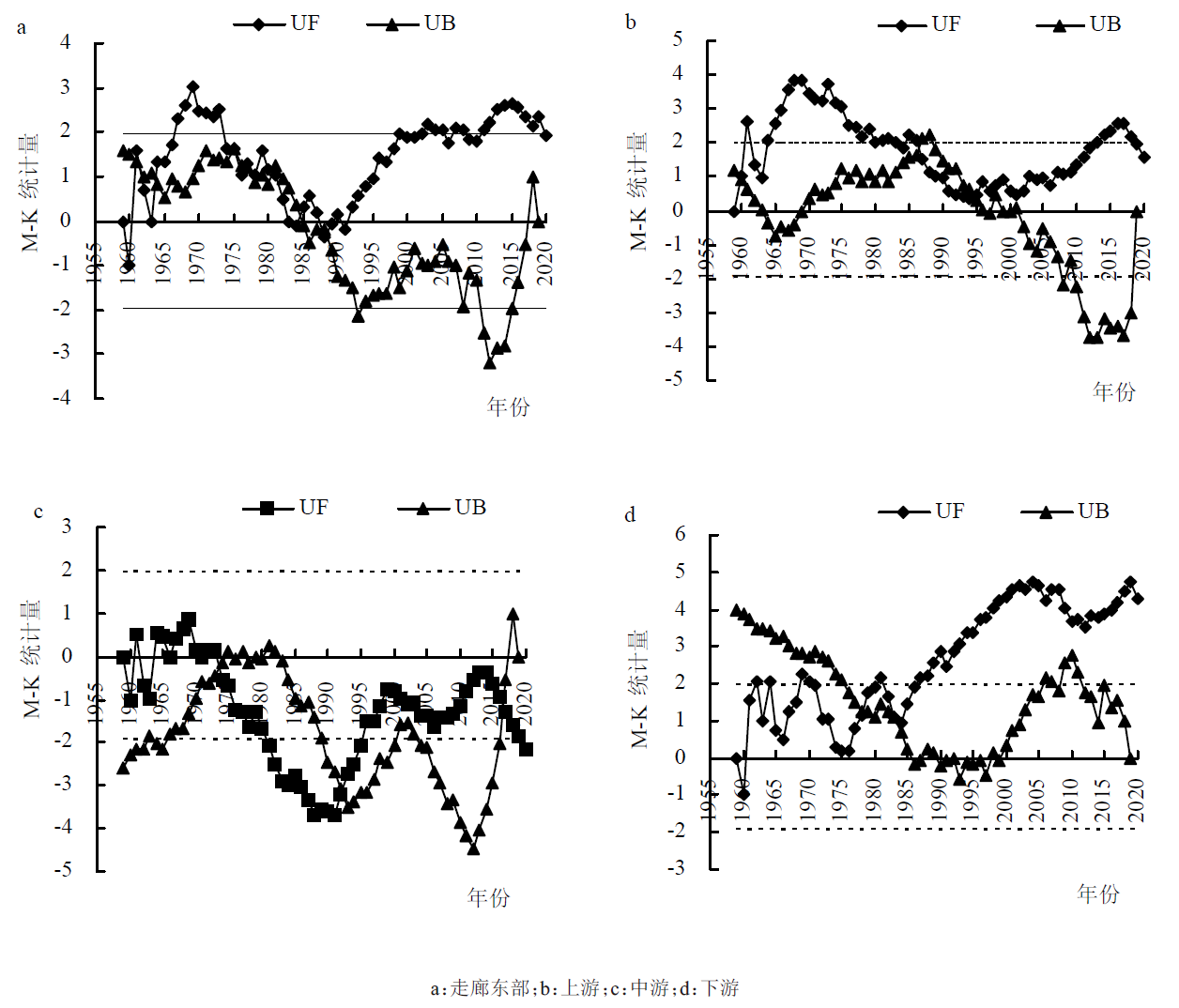
贾文雄, 何元庆, 李宗省, 等. 近50年来河西走廊平原区气候变化的区域特征及突变分析[J]. 地理科学, 2008, 28(4):525-531.
|
| [26] |
刘明春, 张强, 邓振镛, 等. 气候变化对石羊河流域农业生产的影响[J]. 地理科学, 2009, 29(5):727-732.
|
| [27] |
任国玉, 郭军, 徐铭志, 等. 近50年中国地面气候变化基本特征[J]. 气象学报, 2005, 63(6):942-956.
|
| [28] |
翁笃鸣. 试论总辐射的气候学计算方法[J]. 气象学报, 1964, 34(3):304-315.
|
| [29] |
殷代英, 马鹿, 屈建军, 等. 大型光伏电站对共和盆地荒漠区微气候的影响[J]. 水土保持通报, 2017, 37(3):15-21.
|
| [30] |
高晓清, 杨丽薇, 吕芳, 等. 光伏电站对格尔木荒漠地区土壤温度的影响研究[J]. 太阳能学报, 2016(6):1439-1445.
|
| [31] |
赵名彦, 李芳然, 崔利强, 等. 生态脆弱地区光伏电站建设的环境效应分析[J]. 科技创新与应用, 2015(26):22-23.
|
| [32] |
卢霞. 荒漠戈壁区光伏电站建设的环境效应分析[D]. 兰州: 兰州大学, 2013:29-36.
|
| [33] |
普宗朝, 张山清, 宾建华, 等. 新疆乌—昌地区太阳能资源精细化时空变化分析[J]. 干旱区资源与环境, 2012, 26(6):33-39.
|
 ), 任丽雯3, 杨华3, 李兴宇3, 刘明春3(