欢迎访问《中国农学通报》,

中国农学通报 ›› 2022, Vol. 38 ›› Issue (10): 106-111.doi: 10.11924/j.issn.1000-6850.casb2021-0411

所属专题: 现代农业发展与乡村振兴 农业气象

• 资源·环境·生态·土壤 • 上一篇    下一篇

中国农业干旱灾害特征及成因分析

倪深海1,2(), 王亨力2,3, 刘静楠1,2, 顾颖1,2   

  1. 1水文水资源与水利工程科学国家重点实验室,南京 210029
    2南京水利科学研究院,南京 210029
    3河海大学水文水资源学院,南京 210029
  • 收稿日期:2021-04-15 修回日期:2021-07-07 出版日期:2022-04-05 发布日期:2022-05-23
  • 作者简介:倪深海,男,1964年出生,安徽庐江人,教授级高工,博士,主要从事干旱灾害风险防控、水资源配置与管理方面的科学研究。通信地址:210029 江苏省南京市广州路225号,Tel:025-85828511,E-mail: shni@nhri.cn
  • 基金资助:
    国家重点研发计划“大范围长历时干旱灾害成灾机理及演变规律”(2017YFC1502401)

Characteristics and Causes of Agricultural Drought Disasters in China

NI Shenhai1,2(), WANG Hengli2,3, LIU Jingnan1,2, GU Ying1,2   

  1. 1State Key Laboratory of Hydrology-water Resources and Hydraulic Engineering, Nanjing 210029
    2Nanjing Hydraulic Research Institute, Nanjing 210029
    3College of Hydrology and Water Resources, Hohai University, Nanjing 210029
  • Received:2021-04-15 Revised:2021-07-07 Online:2022-04-05 Published:2022-05-23

摘要:

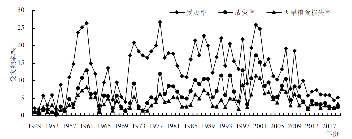
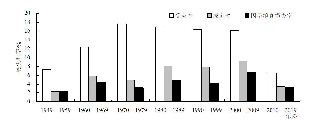
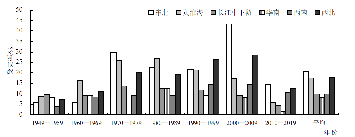
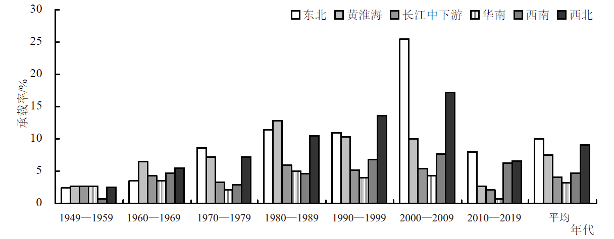
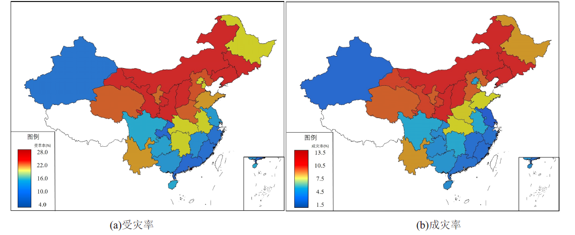
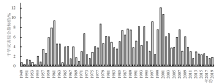
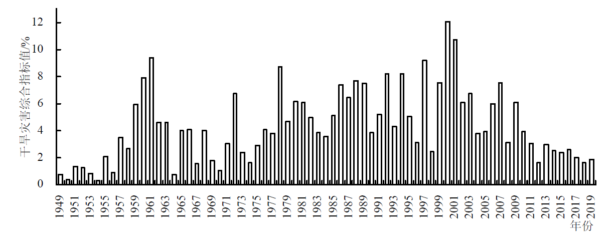
以1949—2019年受灾率、成灾率和因旱粮食损失率3个指标系列,分析了中国干旱灾害的时空分布特征及其变化趋势。统计结果表明,1949—2000年,中国农业受灾率、成灾率、因旱粮食损失率增加速率分别为1.72%/10 a、1.26%/10 a和0.61%/10 a,2001—2019年,农业干旱灾害呈逐步减缓的趋势;从代际间的变化过程来看,20世纪50年代的受灾率、成灾率和因旱粮食损失率分别为7.4%、2.4%和2.3%;到21世纪初分别增加到16.1%、9.3%和6.8%。空间分布上,东北、西北和黄淮海地区受旱成灾较为严重,受灾率和成灾率均超过15%和10%;华南、西南和长江中下游地区受旱成灾相对较缓,受灾率和成灾率低于10%和5%。其中,山西、陕西、辽宁、吉林、内蒙古、河北、甘肃和宁夏等是受旱成灾较为严重的省区。由农业综合干旱指数分析可得,1949—2019年全国发生重旱以上的年份为26年,发生特旱的年份有13年,反映出中国是一个农业干旱灾害频发的国家。气候变暖、水土资源不平衡及人类活动导致下垫面改变是农业干旱灾害加剧的主要原因。

关键词: 农业, 干旱灾害, 时空特征, 气候变暖, 人类活动

Abstract:

This paper analyzed the spatial-temporal distribution characteristics and the evolution of agricultural drought in China from 1949 to 2019 based on three indicators, namely the rate of drought area, disaster and grain loss. The results showed that rate of drought area, disaster and grain loss from 1949 to 2000 increased by 1.72%/10 a, 1.26%/10 a and 0.61%/10 a, respectively. The agricultural drought disaster decreased gradually from 2001 to 2019. From the perspective of decadal changes, the average rate of drought area, disaster and grain loss was 7.4%, 2.4% and 2.3%, respectively in 1950s, which increased to 16.1%, 9.3% and 6.8%, respectively in the early twenty-first century. In terms of spatial distribution, the agricultural drought disaster was more severe in the northeast, northwest and Huang-Huai-Hai region in China, where the rate of drought area and disaster was more than 15% and 10%, respectively. While the drought disaster rate was relatively slow in south China, southwest and the middle-lower reaches of the Yangtze River region, where the rate of drought area and disaster was lower than 10% and 5%, respectively. Shanxi, Shaanxi, Liaoning, Jilin, Inner Mongolia, Hebei, Gansu and Ningxia were the provinces with more severe agricultural drought disaster. According to agricultural comprehensive drought index, from 1949 to 2019, there were 26 years of severe drought and 13 years of extreme drought in China, indicating that China is a country with frequent agricultural drought disasters. This study also concluded that climate warming, the mismatch between water and soil resources, and human activities were the main drivers of the aggravation of agricultural drought in China.

Key words: agriculture, drought disaster, spatial-temporal characteristics, climate warming, human activities

中图分类号: