| [1] |
QUIQUAMPOIX H, MOUSAIN D. Enzymatic hydrolysis of organic phosphorus. In: Benjamin L T. Organic Phosphorus in the Environment[M]. Massachusetts: CABI publishing, 2004:90-112.
|
| [2] |
韩晓飞, 高明, 谢德体, 等. 减磷配施有机肥对紫色土旱坡地磷素流失的消减效应[J]. 环境科学, 2016, 37(7):2770-2778.
|
| [3] |
ZHAO Y J, XIN C, YI S, et al. Impact of Fertilization and Soil Phosphorus Status on Phosphorus Leaching from Soil in Vegetable Greenhouse[J]. Advanced materials research, 2013,610-613:2968-2973.
|
| [4] |
龚道孝. 中国城市饮用水安全监管研究[D]. 杭州: 浙江财经大学, 2020:2-4.
|
| [5] |
WANG J F, CHEN J G, JIN Z X, et al. Simultaneous removal of phosphate and ammonium nitrogen from agricultural runoff by amending soil in lakeside zone of Karst area, Southern China[J]. Agriculture, ecosystems and environment, 2020, 289:106745.
doi: 10.1016/j.agee.2019.106745
URL
|
| [6] |
ELSER J J, BRACKEN M E S, CLELAND E E, et al. Global analysis of nitrogen and phosphorus limitation of primary producers in freshwater, marine and terrestrial ecosystems[J]. Ecology letters, 2007, 10(12):1135-1142.
doi: 10.1111/j.1461-0248.2007.01113.x
pmid: 17922835
|
| [7] |
FICCO K K, THALER E, BRAHANA J V. Strength and Limitations of Karst Groundwater Vulnerability Mapping Methodologies. In: Younos T, Schreiber M, Ficco K K. Karst Water Environment[M]. Springer international publishing AG, 2019, 91-132.
|
| [8] |
张军以, 王腊春, 马小雪, 等. 西南岩溶地区地下水污染及防治途径[J]. 水土保持通报, 2014, 34(2):245-249.
|
| [9] |
PU J B, YUAN D X, ZHANG C, et al. Hydrogeochemistry and possible sulfate sources in karst groundwater in Chongqing, China[J]. Environmental earth sciences, 2013, 68(1):159-168.
doi: 10.1007/s12665-012-1726-8
URL
|
| [10] |
谷佳慧, 杨奇勇, 蒋忠诚, 等. 广南县幅岩溶区与非岩溶区土壤碳氮磷生态化学计量比空间变异分析[J]. 中国岩溶, 2018, 37(5):761-769.
|
| [11] |
罗广飞, 韩志伟, 田永著, 等. 岩溶流域不同水体氮磷分布、影响因素及富营养化评价[J]. 中国农村水利水电, 2020(10):94-99.
|
| [12] |
田永著. 岩溶山区农业面源磷素污染过程研究[D]. 贵阳: 贵州大学, 2020:14-17.
|
| [13] |
陈志诚, 于天仁. 土壤发生中的化学过程[M]. 北京: 科学出版社, 1990:51-57.
|
| [14] |
翟龙波, 章熙锋, 陈靖, 等. 施肥对坡地土壤团聚体与磷素赋存形态的影响[J]. 西南大学学报(自然科学版), 2019, 41(7):105-115.
|
| [15] |
李玮, 乔玉强, 陈欢, 等. 秸秆还田配施氮肥对砂姜黑土有机质组分与碳库管理指数的影响[J]. 生态与农村环境学报, 2014, 30(4):475-480.
|
| [16] |
朱永青, 崔云霞, 李伟迪, 等. 太滆运河流域不同用地方式下土壤pH值、有机质及氮磷含量特征分析[J]. 生态与农村环境学报, 2020, 36(2):171-178.
|
| [17] |
鲁如坤. 土壤农业化学分析方法[M]. 北京: 中国农业科技出版社, 2000:12-17.
|
| [18] |
文波龙, 刘兴土, 张乃明. 滇池大清河流域农田土壤磷素空间变异特征及对地表径流的影响[J]. 土壤学报, 2012, 49(1):173-178.
|
| [19] |
赵楚, 盛茂银, 白义鑫, 等. 喀斯特石漠化地区不同土地利用类型土壤氮磷有效性及其环境影响因子[J]. 应用生态学报, 2021, 32(4):1383-1392.
doi: 10.13287/j.1001-9332.202104.018
|
| [20] |
鲁如坤. 土壤磷素水平和水体环境保护[J]. 磷肥与复肥, 2003(1):4-8.
|
| [21] |
NIU M F, WEN L Q, ZHAO M Q, et al. Simulation of Relationship Between Dissoluble Phosphorus Loss and Runoff Time[J]. Environmental science, 2008, 29(9):2580-2585.
|
| [22] |
张瑜, 张黎明, 周碧青, 等. 基于GIS技术的耕地有效磷富集与生态风险评价——以福建省泰宁县为例[J]. 农业环境科学学报, 2015, 34(2):326-336.
|
| [23] |
蔡观, 胡亚军, 王婷婷, 等. 基于生物有效性的农田土壤磷素组分特征及其影响因素分析[J]. 环境科学, 2017, 38(4):1606-1612.
|
| [24] |
鲁艳红, 廖育林, 聂军, 等. 长期施肥红壤性水稻土磷素演变特征及对磷盈亏的响应[J]. 土壤学报, 2017, 54(6):1471-1485.
|
| [25] |
孙桂芳, 金继运, 石元亮. 土壤磷素形态及其生物有效性研究进展[J]. 中国土壤与肥料, 2011(2):1-9.
|
| [26] |
张素霞, 吕家珑, 杨瑜琪, 等. 黄土高原不同植被坡地土壤无机磷形态分布研究[J]. 干旱地区农业研究, 2008, 26(1):29-32.
|
| [27] |
成瑞喜, 贾平. 中酸性土壤无要磷形态及生物学有效性[J]. 热带亚热带土壤科学, 1998, 7(1):6-10.
|
| [28] |
陈刚才, 甘露, 王仕禄, 等. 土壤中元素磷的地球化学[J]. 地质地球化学, 2001, 29(2):78-81.
|
| [29] |
张倩, 韩贵琳, 柳满, 等. 贵州普定喀斯特关键带土壤磷分布特征及其控制因素[J]. 生态学杂志, 2019, 38(2):321-328.
|
| [30] |
胡宁, 袁红, 蓝家程, 等. 岩溶石漠化区不同植被恢复模式土壤无机磷形态特征及影响因素[J]. 生态学报, 2014, 34(24):7393-7402.
|
| [31] |
苗淑杰, 韩晓增, 乔云发, 等. 不同作物对黑土中磷素形态及有效性的影响[J]. 土壤通报, 2009, 40(1):105-109.
|
| [32] |
成瑞喜, 刘景福, 徐芳森. 磷肥对中酸性土壤无机磷形态转化及其有效性的影响[J]. 土壤, 1995, 1(5):225-268.
|
| [33] |
刘建玲, 张福锁. 小麦-玉米轮作长期肥料定位试验中土壤磷库的变化Ⅰ.磷肥产量效应及土壤总磷库、无机磷库的变化[J]. 应用生态学报, 2000, 11(3):360-364.
|
| [34] |
李建查, 张国盛, 倪振伟, 等. 退耕对滇池湖滨土壤理化性质与无机磷分布的影响[J]. 水土保持通报, 2015, 35(3):95-100.
|
| [35] |
FOX T R, COMERFORD N B, MCFEE W W. Phosphorus and Aluminum Release from a Spodic Horizon Mediated by Organic Acids[J]. Soil Science Society of America Journal, 1990, 54(6):1763-1767.
doi: 10.2136/sssaj1990.03615995005400060043x
URL
|
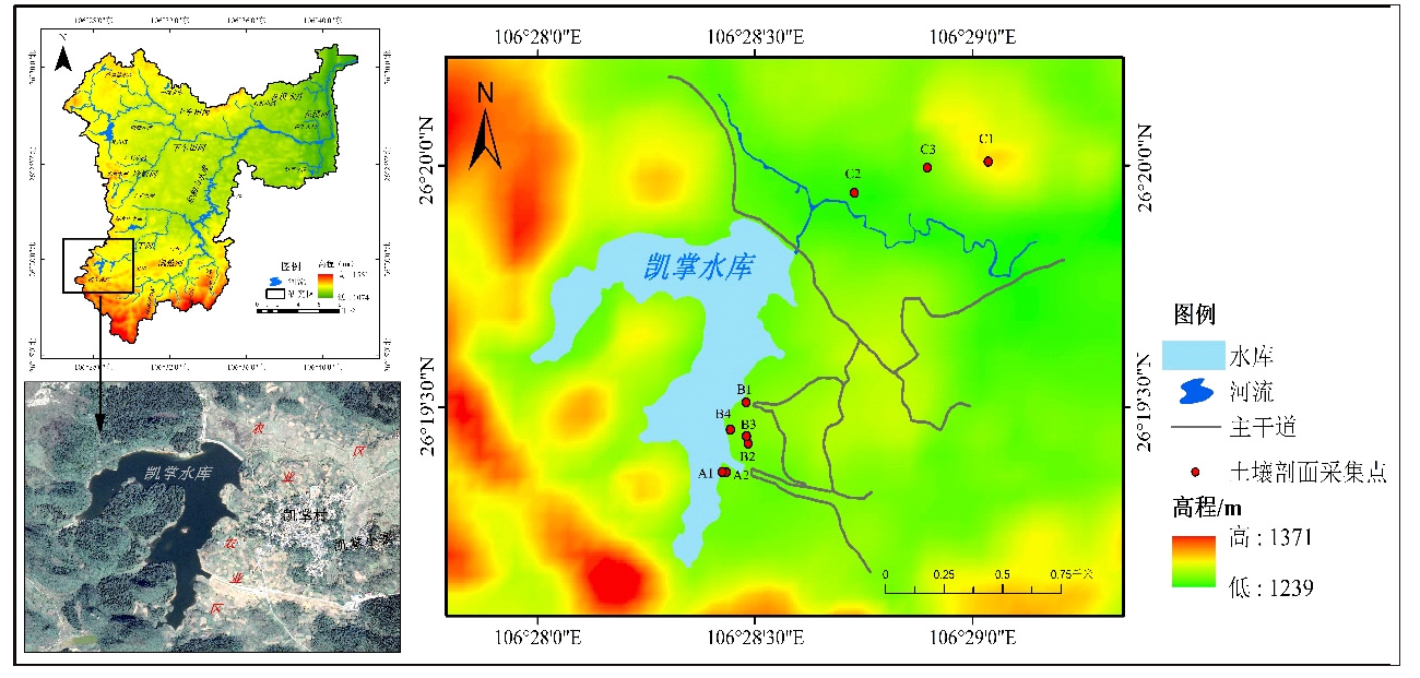
 ), 田永著2, 韩志伟1,3(