欢迎访问《中国农学通报》,

中国农学通报 ›› 2021, Vol. 37 ›› Issue (35): 73-77.doi: 10.11924/j.issn.1000-6850.casb2021-0092

所属专题: 资源与环境

• 资源·环境·生态·土壤·气象 • 上一篇    下一篇

北京市水土资源匹配时空模式研究

王妍1,2(), 雷晓辉1(), 张玉3(), 崔娜4   

  1. 1中国水利水电科学研究院 流域水循环模拟与调控国家重点实验室,北京 100038
    2北京市水利自动化研究所,北京 100036
    3中国测绘科学研究院,北京 100036
    4陕西省地质科技中心,西安 710054
  • 收稿日期:2021-01-25 修回日期:2021-03-18 出版日期:2021-12-15 发布日期:2022-01-07
  • 通讯作者: 雷晓辉,张玉
  • 作者简介:王妍,女,1983年出生,河北保定人,高级工程师,博士,研究方向为水务信息化、时空数据分析。通信地址:100036 北京市海淀区翠微路甲三号,Tel:010-56695864,E-mail: wangyan@lreis.ac.cn
  • 基金资助:
    青年科学基金“随机森林和智能体耦合的大区域高精度人口分布模拟方法”(71903183)

Space-temporal Matching Pattern of Agricultural Land and Water Resources in Beijing

Wang Yan1,2(), Lei Xiaohui1(), Zhang Yu3(), Cui Na4   

  1. 1China State Key Laboratory of Simulation and Regulation of Water Cycle in River Basin, China Institute of Water Resources and Hydropower Research, Beijing 100038
    2Beijing Research Institute of Water Affair Automation, Beijing 100036
    3Chinese Academy of Surveying & Mapping, Beijing 100036;
    4Shaanxi Geological Science and Technology Center, Xi’an 710054;
  • Received:2021-01-25 Revised:2021-03-18 Online:2021-12-15 Published:2022-01-07
  • Contact: Lei Xiaohui,Zhang Yu

摘要:

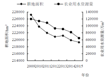
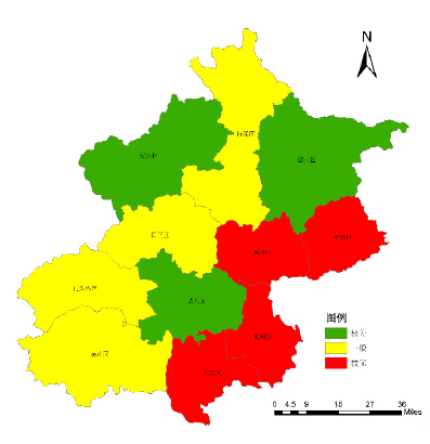
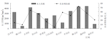
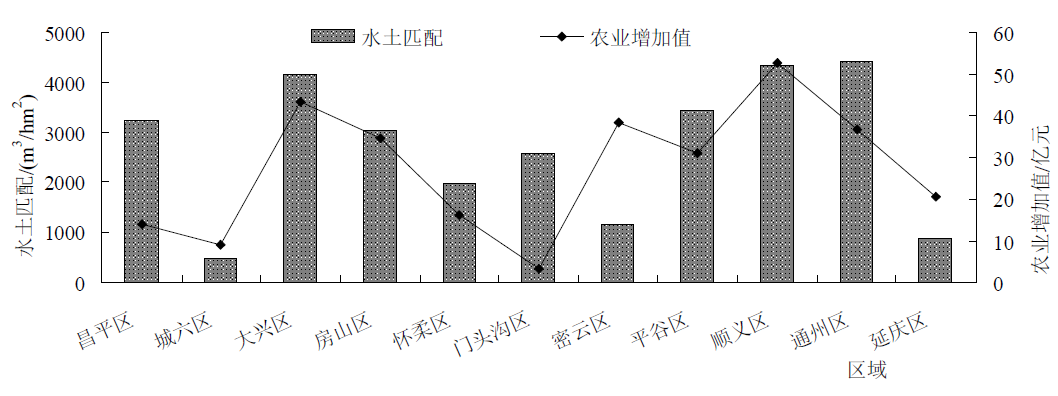
随着各地城市化进程的不断推进,自然资源及城市问题之间的矛盾也日益凸显。虽然各地农业发展仍保持增长态势,但是与农业息息相关的水资源和土地资源匹配程度略显不足。本研究利用全市16个市辖区2009—2015年的水资源与耕地资源、农业经济状况为指标变量,首先计算时空不同维度上的水土匹配程度,然后将各区的水土匹配情况与农业经济做相关性分析。结果显示:全市的水土匹配系数在2012年达到一个小高峰后逐年减小,总体呈现条带状分布,区际间的水土匹配系数也有明显差异,东部整体水平好于西部,南部好于北部地区,水土匹配状况较好的地区有大兴、顺义和通州,而城六区略差;并且水土匹配系数与农业经济呈现统计学意义上的正相关。本研究中给出的水土匹配情况的技术框架简单可行,并且其结果也可为各地农业未来发展的进一步优化调整提供科学依据。

关键词: 水资源, 耕地资源, 水土匹配, 时空模式, 时空分异性, 莫兰指数, 基尼系数

Abstract:

With the steady improvement of urbanization, the contradiction between resources and urban issues has become increasingly prominent. Agricultural development still maintains a steadily increasing momentum, but water resources and land resources that are closely related to agriculture are slightly insufficient. This study used the water resources, agricultural land and agricultural economic conditions of 16 districts of Beijing from 2009 to 2015 as index variables, firstly calculated the matching degree of agricultural land and water in time and space dimensions, and then made correlation analysis between the matching degree and agricultural economy at district level. The results showed that the matching degree of water and agricultural land in the whole city decreased year by year after reaching a small peak in 2012, it showed a strip distribution in whole, and the degree was also significantly different among those districts. The overall level of the eastern region was better than that of the western region, and the southern region was better than that of the northern region. The matching condition was better in Daxing, Shunyi and Tongzhou, while that of the six districts of the urban area were slightly worse. Moreover, the matching degree of water and agricultural land was positively correlated with agricultural economy. The technical framework of water and land resource matching given in this study is simple and feasible, and the results could also provide a scientific basis for further optimization and adjustment of agricultural development in the future.

Key words: water resources, cultivated land resource, soil and water matching, space-temporal pattern, space-temporal heterogeneity, Moran’s I index;, Gini coefficient

中图分类号: