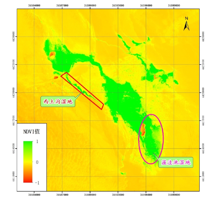
| [1] |
Thompson W. Past Global Changes and Their Significance for the Future[J]. Journal of Paleolimnology, 2001, 26(2).
|
| [2] |
Paul A, O'Gorman, Tapio S. et al. The Physical Basis for Increases in Precipitation Extremes in Simulations of 21st-Century Climate Change[J]. roceedings of the National Academy of Sciences of the United States of America, 2009, 106(35).
|
| [3] |
叶培龙, 张强, 王莺, 徐丽丽, 韩林君, 李蓉. 近40年黄河上游气候变化特征及其对生态植被和径流量的影响[J/OL]. 大气科学学报:1-21[2021-09-02]. http://kns.cnki.net/kcms/detail/32.1803.P.20201104.1723.004.html.
|
| [4] |
吕天宇, 曾晨, 刘泽瑾, 杨婧. 空间互动视角下CO2排放驱动因素及溢出效应——基于全球98个国家的数据分析[J]. 生态学报, 2020, 40(24):8974-8987.
|
| [5] |
张仲杰, 陈少勇, 杨鑫, 等. 中国西北东部降水量变化的空间分布及突变特征[J]. 农学学报, 2017, 7(10):84-89.
|
| [6] |
曹君, 张正栋, 陈宋佳, 等. 1996—2015年粤港澳大湾区生态系统服务对景观格局变化的响应[J]. 华南师范大学学报:自然科学版, 2020, 52(5):93-105.
|
| [7] |
孟阳阳, 何志斌, 刘冰, 等. 干旱区绿洲湿地空间分布及生态系统服务价值变化——以三大典型内陆河流域为例[J]. 资源科学, 2020, 42(10):2022-2034.
|
| [8] |
董雪, 李永华, 辛智鸣, 等. 敦煌西湖荒漠-湿地生态系统优势物种生态位研究[J]. 生态学报, 2020, 40(19):6841-6849.
|
| [9] |
马维伟. 尕海湿地生态系统土壤特征及温室气体排放研究[D]. 兰州:甘肃农业大学, 2014.
|
| [10] |
Song F, Su F L, Mi C X, et al. Analysis of driving forces on wetland ecosystem srvices value change: A case in Northeast China[J]. Science of the Total Environment, 2021: 751.
|
| [11] |
吴晓燕, 田昆. 全球气候变化对高原湿地植物的影响研究[J]. 绿技, 2016(10):125-127,132.
|
| [12] |
Virginia B, Jon K. Potential impacts and interactions in wetlands of the Unite States[J]. JAWRA Journal of the American Water Resources Association, 2000, 36(2).
|
| [13] |
党国锋, 纪树志. 基于GIS的秦巴山区土地生态敏感性评价──以陇南山区为例[J]. 中国农学通报, 2017, 33(7):118-127.
|
| [14] |
麻守仕. 甘肃敦煌阳关国家级自然保护区阳关湿地生态保护对策分析[J]. 甘肃农业, 2018(2):45-47.
|
| [15] |
代雪玲, 谢建平, 逯军峰, 等. 敦煌阳关保护区湿地植物群落优势种种间关系分析[J]. 中国农学通报, 2016, 32(13):118-124.
|
| [16] |
纪树志. 山区土地生态敏感性评价及空间分布特征研究[D]. 兰州:西北师范大学, 2017.
|
| [17] |
陈建军. 青藏高原高寒草地植被覆盖度变化及其环境影响因子研究[J]. 测绘学报, 2020, 49(4):533.
|
| [18] |
阿荣, 毕其格, 董振华. 基于MODIS/NDVI的锡林郭勒草原植被变化及其归因[J]. 资源科学, 2019, 41(7):1374-1386.
|
| [19] |
毛英, 原作强, 高清明, 等. 基于MODIS-NDVI的乐安湿地植被覆盖动态分析[J]. 四川林业科技, 2019, 40(3):42-46,70.
|
| [20] |
Pan F F, Xie J P, Lin J M, et al. Evaluation of Climate Change Impacts on Wetland Vegetation in the Dunhuang Yangguan National Nature Reserve in Northwest China Using Landsat Derived NDVI[J]. Remote Sensing, 2018, 10(5).
|
| [21] |
代雪玲, 谢建平, 王蒙, 等. 敦煌阳关国家级自然保护区湿地植物群落特征与物种多样性[J]. 湿地科学, 2015, 13(3):381-386.
|
 )
)