欢迎访问《中国农学通报》,
中国农学通报 ›› 2024, Vol. 40 ›› Issue (25): 155-164.doi: 10.11924/j.issn.1000-6850.casb2023-0760
• 农业信息·科技教育 • 上一篇
王锦杰1( ), 陈昊2(), 庞礴1, 周航1, 沈伟1, 颜雅琼1, 徐敏3
收稿日期:2023-11-08
修回日期:2024-06-18
出版日期:2024-09-05
发布日期:2024-08-27
通讯作者:
作者简介:王锦杰,男,1992年出生,工程师,硕士,主要从事农业遥感研究。通信地址:223800 江苏省宿迁市宿城区洪泽湖路722号,E-mail:wjjpro@foxmail.com。
基金资助:
WANG Jinjie1(), CHEN Hao2(), PANG Bo1, ZHOU Hang1, SHEN Wei1, YAN Yaqiong1, XU Min3
Received:2023-11-08
Revised:2024-06-18
Published:2024-09-05
Online:2024-08-27
摘要:
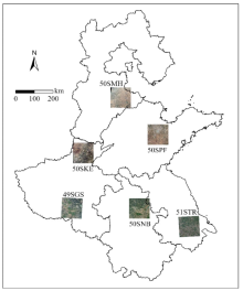
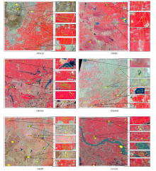
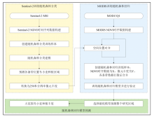
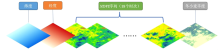
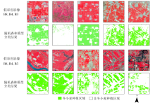
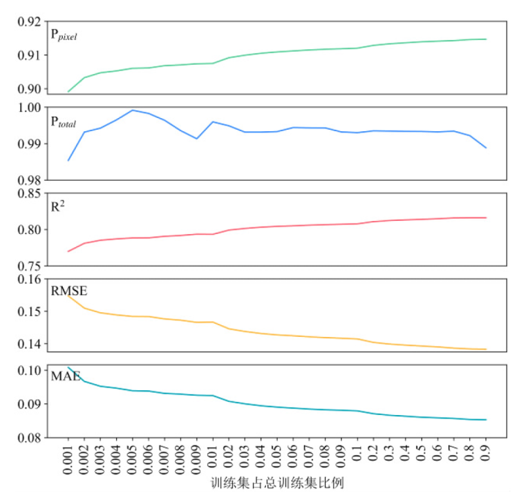
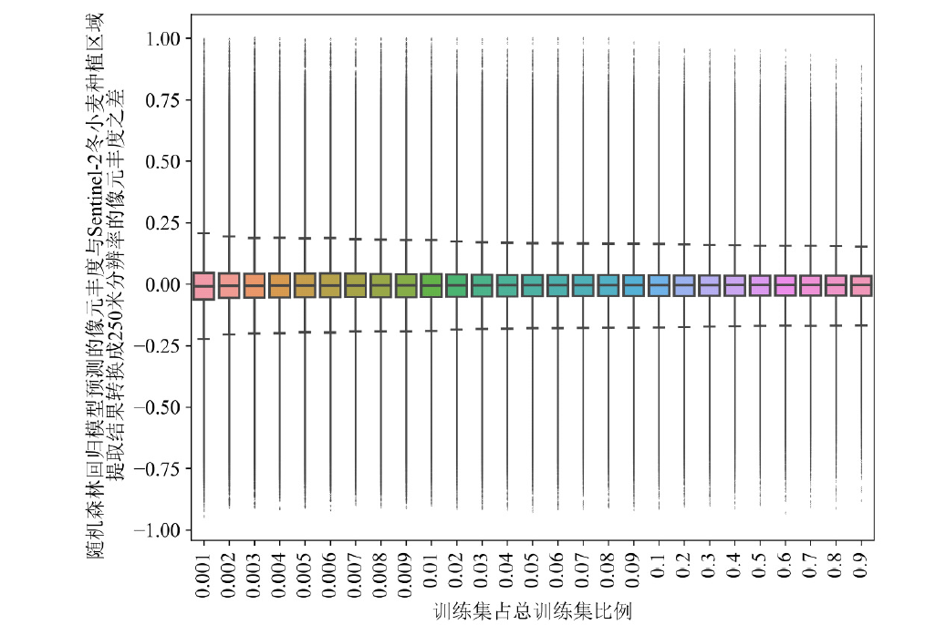
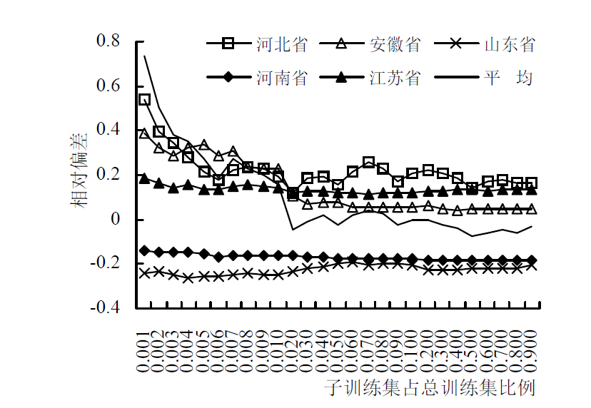
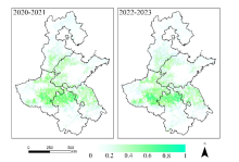
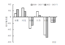
针对大范围冬小麦种植丰度定量评估和种植面积测量业务化中存在的,高分辨率影像覆盖能力较低难以在大空间范围内推广应用,与中分辨率影像提取精度较低之间相互制约的现实问题,选择均匀分布于黄淮海平原的6个Sentinel-2条带位置为试验区,通过分别构建随机森林分类模型提取Sentinel-2的冬小麦种植区域,并将Sentinel-2冬小麦种植区域合成为250 m空间分辨率的种植丰度,结合时序MODIS NDVI训练随机森林回归模型,预测得到黄淮海平原冬小麦种植丰度,从而实现大范围冬小麦种植丰度定量评估和种植面积测量。相比传统MODIS NDVI时序数据提取冬小麦种植区域,还需额外进行混合像元分解后才能得到种植丰度,本研究使用随机森林回归方法直接获得了每个像元的种植丰度,省去了混合像元分解步骤。训练的各条带位置随机森林分类模型,F1 score达0.9983以上,当训练集样本量占总样本量的2%以上时随机森林回归模型趋于稳定,当样本量占比达50%时模型最适宜使用,R2达0.8140,样本量占比达90%时,回归模型R2达到最大值为0.8162。使用模型测量冬小麦种植丰度和种植面积分别能够达到Sentinel-2精度的91%和99%以上,满足了大范围冬小麦种植丰度定量评估和种植面积测量的业务化精度要求。
王锦杰, 陈昊, 庞礴, 周航, 沈伟, 颜雅琼, 徐敏. 基于多源卫星的黄淮海平原冬小麦种植丰度定量评估[J]. 中国农学通报, 2024, 40(25): 155-164.
WANG Jinjie, CHEN Hao, PANG Bo, ZHOU Hang, SHEN Wei, YAN Yaqiong, XU Min. Quantitative Assessment of Winter Wheat Planting Abundance in Huang-Huai-Hai Plain Based on Multi-source Satellite Data[J]. Chinese Agricultural Science Bulletin, 2024, 40(25): 155-164.

| 条带号 | 过境日期(年-月-日) |
|---|---|
| 49SGS | 2021-11-08、2021-11-13、2021-11-18、2021-11-23、2021-12-03、2021-12-13、2021-12-18、2021-12-28、2022-02-01、 2022-03-03、2022-03-08、2022-03-28、2022-04-02、2022-04-07、2022-05-02、2022-05-07、2022-06-16 |
| 50SKE | 2021-10-24、2021-11-08、2021-11-13、2021-11-18、2021-11-23、2021-12-03、2021-12-13、2022-01-02、2022-01-17、 2022-02-01、2022-02-26、2022-03-08、2022-04-02、2022-04-07、2022-05-02、2022-05-17、2022-06-01 |
| 50SMH | 2021-10-11、2021-10-21、2021-11-10、2021-11-25、2021-11-30、2021-12-05、2021-12-20、2021-12-30、2022-01-29、2022-02-03、 2022-02-08、2022-02-23、2022-03-05、2022-03-10、2022-04-04、2022-040-9、2022-04-19、2022-06-03 |
| 50SNB | 2021-11-12、2021-11-22、2021-11-27、2021-12-02、2021-12-17、2021-12-27、2022-01-01、2022-02-20、2022-03-02、2022-03-07、 2022-04-06、2022-04-11、2022-04-21、2022-05-06、2022-05-16、2022-05-21、2022-06-15、2022-06-20、2022-06-25 |
| 50SPF | 2021-10-13、2021-10-23、2021-11-12、2021-11-27、2021-12-02、2022-01-01、2022-01-06、2022-01-11、2022-01-16、 2022-02-05、2022-02-10、2022-02-25、2022-03-02、2022-03-07、2022-03-27、2022-04-11、2022-06-20 |
| 51STR | 2021-10-05、2021-10-30、2021-11-09、2021-11-14、2021-11-24、2021-12-04、2021-12-19、2022-02-27、 2022-03-04、2022-03-24、2022-04-08、2022-05-03、2022-06-17 |


| 条带号 | 准确率 | 精准率 | 召回率 | F1 |
|---|---|---|---|---|
| 49SGS | 0.9997 | 0.9996 | 0.9989 | 0.9993 |
| 50SKE | 0.9999 | 0.9993 | 1.0000 | 0.9997 |
| 50SMH | 0.9998 | 0.9991 | 0.9991 | 0.9991 |
| 50SNB | 0.9998 | 1.0000 | 0.9998 | 0.9999 |
| 50SPF | 0.9999 | 1.0000 | 0.9910 | 0.9995 |
| 51STR | 0.9999 | 0.9965 | 1.0000 | 0.9983 |


| [1] |
陈水森, 柳钦火, 陈良富, 等. 粮食作物播种面积遥感监测研究进展[J]. 农业工程学报, 2005, 21(6):166-171.
|
| [2] |
邹金秋, 陈佑启,
|
| [3] |
许文波, 张国平, 范锦龙, 等. 利用MODIS遥感数据监测冬小麦种植面积[J]. 农业工程学报, 2007, 23(12):144-149.
|
| [4] |
李乐, 张锦水, 朱文泉, 等. 地块支持下MODIS-NDVI时间序列冬小麦种植面积测量研究[J]. 光谱学与光谱分析, 2011, 31(5):1379-1383.
|
| [5] |
黄珂, 刘忠, 杨丽芳. 基于多年MODIS-NDVI的黄淮海农区冬小麦生产力评价[J]. 农业工程学报, 2014, 30(2):153-161.
|
| [6] |
|
| [7] |
吴风华, 郎婷婷, 江东, 等. 京津冀地区冬小麦播种面积快速提取技术研究[J]. 江苏农业科学, 2019, 47(16):224-229.
|
| [8] |
杨欢, 邓帆, 张佳华, 等. 基于MODIS EVI的江汉平原油菜和冬小麦种植信息提取研究[J]. 国土资源遥感, 2020, 32(3):208-215.
|
| [9] |
郭新, 王乃江, 张玲玲, 等. 基于Google Earth Engine平台的关中冬小麦面积时空变化监测[J]. 干旱地区农业研究, 2020, 38(3):275-280.
|
| [10] |
|
| [11] |
谢登峰, 张锦水, 潘耀忠, 等. Landsat 8和MODIS融合构建高时空分辨率数据识别秋粮作物[J]. 遥感学报, 2015, 19(5):791-805.
|
| [12] |
陆俊, 黄进良, 王立辉, 等. 基于时空数据融合的江汉平原水稻种植信息提取[J]. 长江流域资源与环境, 2017, 26(6):874-881.
|
| [13] |
王连喜, 徐胜男, 李琪, 等. 基于决策树和混合像元分解的江苏省冬小麦种植面积提取[J]. 农业工程学报, 2016, 32(5):182-187.
|
| [14] |
顾晓鹤, 潘耀忠, 朱秀芳, 等. MODIS与TM冬小麦种植面积遥感测量一致性研究——小区域实验研究[J]. 遥感学报, 2007(3):350-358.
|
| [15] |
崔璐, 杜华强, 周国模, 等. 决策树结合混合像元分解的中国竹林遥感信息提取[J]. 遥感学报, 2019, 23(1):166-176.
|
| [16] |
李霞, 王飞, 徐德斌, 等. 基于混合像元分解提取大豆种植面积的应用探讨[J]. 农业工程学报, 2008, 24(1):213-217.
|
| [17] |
李根, 景元书, 王琳, 等. 基于MODIS时序植被指数和线性光谱混合模型的水稻面积提取[J]. 大气科学学报, 2014, 37(1):119-126.
|
| [18] |
FATCHURRACHMAN, RUDIYANTO,
|
| [19] |
潘力, 夏浩铭, 王瑞萌, 等. 基于Google Earth Engine的淮河流域越冬作物种植面积制图[J]. 农业工程学报, 2021, 37(18):211-218.
|
| [20] |
薛宇飞, 张军, 张萍, 等. 基于Sentinel-2遥感影像的烟草种植信息精准提取[J]. 中国烟草科学, 2022, 43(1):96-106.
|
| [21] |
牟昱璇, 邬明权, 牛铮, 等. 南方地区复杂条件下的耕地面积遥感提取方法[J]. 遥感技术与应用, 2020, 35(5):1127-1135.
doi: 10.11873/j.issn.1004-0323.2020.5.1127 |
| [22] |
陈彦四, 黄春林, 侯金亮, 等. 基于多时相Sentinel-2影像的黑河中游玉米种植面积提取研究[J]. 遥感技术与应用, 2021, 36(2):324-331.
doi: 10.11873/j.issn.1004-0323.2021.2.0324 |
| [23] |
|
| [24] |
|
| [25] |
张卫春. 基于Sentinel-2数据的低山丘陵区水稻种植面积监测[D]. 重庆: 西南大学, 2021.
|
| [1] | 丁豪, 高海涛, 毕香君, 李升东. 不同播种方式对冬小麦产量构成和旗叶光合特性的影响[J]. 中国农学通报, 2024, 40(9): 9-19. |
| [2] | 段国辉, 田文仲, 高海涛, 杨洪强, 张少澜, 董中东, 温红霞, 吕树作, 顾晶晶. 不同灌水对黄淮冬小麦茎秆、产量及水分利用效率的影响[J]. 中国农学通报, 2024, 40(5): 1-8. |
| [3] | 杨艳, 赵伟金, 谢益燕, 马骏洁, 彭仁, 杨德海, 郑仕方, 孙永华, 李晓婷, 李先才. 大理州植烟区‘KRK26’烟叶化学成分与感官质量特征和土壤养分的关系[J]. 中国农学通报, 2024, 40(25): 132-139. |
| [4] | 吴东丽, 刘聪, 郭超凡, 丁明明, 吴苏, 阙艳红, 姜明梁, 李雁. 基于多源遥感数据与模型对比的冬小麦土壤含水量区域监测研究[J]. 中国农学通报, 2024, 40(25): 147-154. |
| [5] | 尹逊栋, 吕广德, 亓晓蕾, 陈永军, 牟秋焕, 孙盈盈, 孙宪印, 米勇, 钱兆国, 崔兆韵, 邹俊丽. 播期对不同穗型冬小麦生长及产量的影响[J]. 中国农学通报, 2024, 40(24): 9-16. |
| [6] | 武术兰, 任频频, 侯术海, 王树森, 宋佰联, 黄峰. 鲁西平原冬小麦水分生产力时空格局及其变化分解[J]. 中国农学通报, 2024, 40(23): 7-15. |
| [7] | 韩明明, 牟群, 李文倩, 陈军, 吕连杰, 张海军, 安霞, 李晓宇, 常振凯. 秸秆还田条件下氮磷钾养分管理对冬小麦籽粒灌浆特性及产量的影响[J]. 中国农学通报, 2024, 40(23): 1-6. |
| [8] | 薛远赛, 彭科研, 陈希彦, 李秋芹, 张艳, 邹士国, 朱静行, 韩伟. 沟播对中轻度盐碱地小麦土壤养分、叶片荧光动力学参数及产量的影响研究[J]. 中国农学通报, 2024, 40(22): 1-7. |
| [9] | 陈英丽, 毕建杰. 灌溉和干旱及氮素水平对孕穗期冬小麦冠层光分布影响[J]. 中国农学通报, 2024, 40(21): 12-19. |
| [10] | 苏朝丞, 葛怡成, 谢葭颖, 许浩翊, 王啸天. 石河子棉花生长关键期与产量动态预报研究[J]. 中国农学通报, 2024, 40(2): 102-106. |
| [11] | 焦润安, 李旭华, 齐月, 雷俊, 苟志文, 臧亚军, 薛潇. 黄土高原半干旱雨养农业区冬小麦气候适宜度评价——以通渭县为例[J]. 中国农学通报, 2024, 40(17): 73-80. |
| [12] | 张红妮, 李祥科, 张洪芬, 张天峰, 周忠文, 车可. 陇东塬区春季气候变化对冬小麦产量的影响评估[J]. 中国农学通报, 2024, 40(11): 78-83. |
| [13] | 樊鹏, 王自威, 邵红旗, 杨青伟, 王磊, 杨喜会. 基于耕地资源质量分类监测的土壤条件变化对粮食产量的影响——以河南省兰考县为例[J]. 中国农学通报, 2024, 40(10): 83-88. |
| [14] | 刘雅娜, 俄胜哲, 王兰英, 马晓峰, 袁金华, 张鹏, 路港滨, 冶赓康, 赵天鑫, 王钰轩. 可应用于农林领域保水剂的研究进展[J]. 中国农学通报, 2023, 39(6): 82-89. |
| [15] | 叶彩红, 许窕孜, 张中瑞, 朱航勇, 张耕, 何茜, 丁晓纲. 北江流域5种林分类型土壤重金属含量变异性研究[J]. 中国农学通报, 2023, 39(34): 114-122. |
| 阅读次数 | ||||||
|
全文 |
|
|||||
|
摘要 |
|
|||||