欢迎访问《中国农学通报》,
中国农学通报 ›› 2025, Vol. 41 ›› Issue (36): 119-131.doi: 10.11924/j.issn.1000-6850.casb2025-0656
有思1( ), 姜湖园1(), 有维2, 林聪1
收稿日期:2025-08-06
修回日期:2025-10-08
出版日期:2025-12-25
发布日期:2025-12-25
通讯作者:
作者简介:有思,女,1996年出生,工程师,硕士,主要从事农牧林气象研究和服务。通信地址:021008 内蒙古自治区呼伦贝尔市海拉尔区根河路与哈萨尔大街交叉口附近 海拉尔区河东根河路、呼伦贝尔市气象局,Tel:0470-8244470,E-mail:736460981@qq.com。
基金资助:
YOU Si1(), JIANG Huyuan1(), YOU Wei2, LIN Cong1
Received:2025-08-06
Revised:2025-10-08
Published:2025-12-25
Online:2025-12-25
摘要:
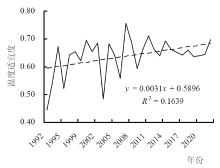
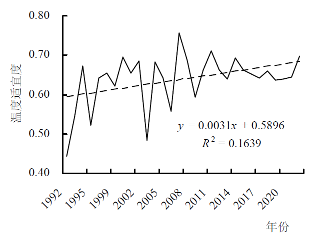
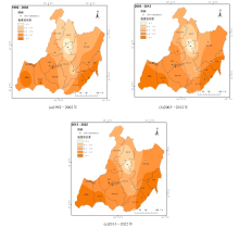
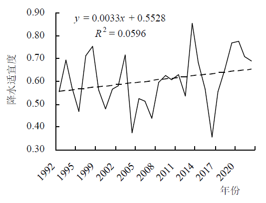
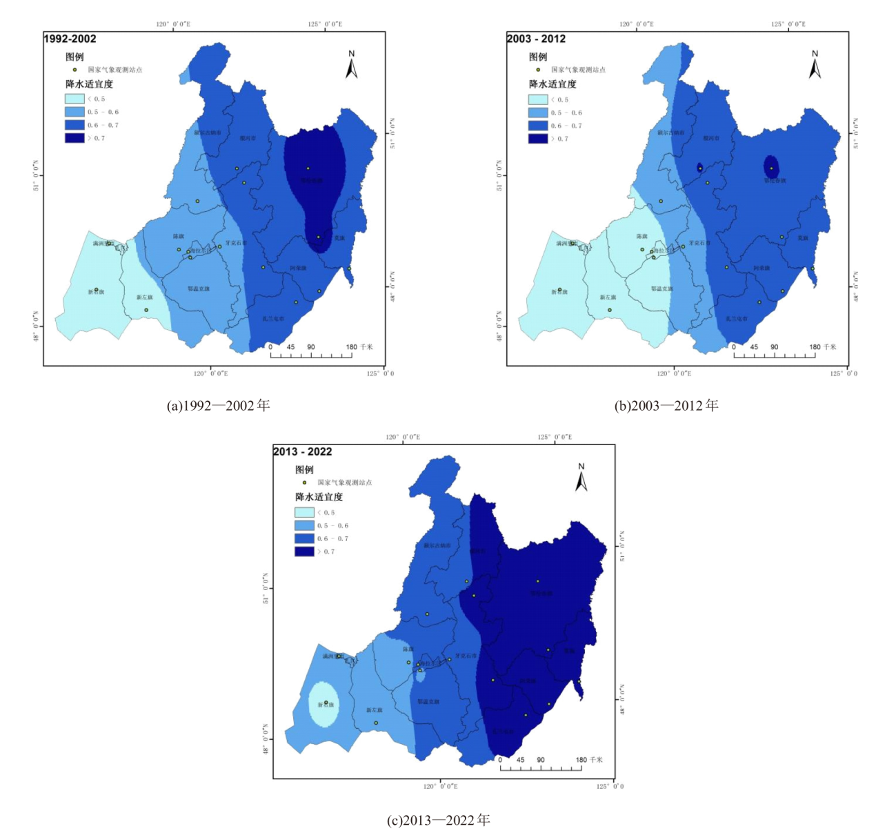
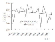
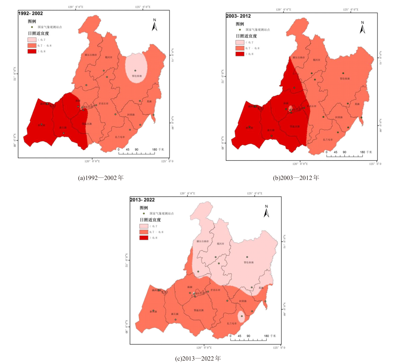
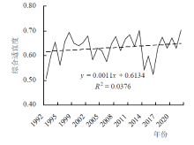
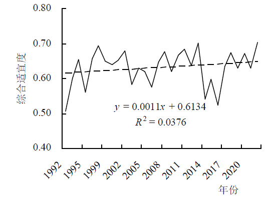
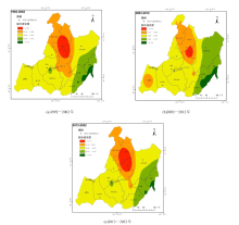
本研究基于1992—2022年气象资料和大豆生育期数据,构建气候适宜度模型,结合线性趋势分析、自然断点法及反距离权重插值等方法,分析呼伦贝尔地区大豆种植气候适宜性的时空变化特征,划分大豆种植适宜区。结果表明:在全球气候变化背景下,呼伦贝尔地区大豆种植综合适宜度呈波动性变化,总体呈前期平稳上升、后期略有下降;其中温度适宜度、降水适宜度均呈波动上升趋势,日照适度则前期波动上升、后期波动下降。空间分布上,日照、温度、降水及综合适宜度差异显著:综合适宜度高值区主要位于东部,其次为西部,中部综合适宜度最低;温度适宜度呈自东西两侧向中间递减分布;降水适宜呈自东向西递减分布;日照适宜度与降水适宜度空间分布呈相反趋势,为自东向西递增分布。总体而言,呼伦贝尔市东南部气候条件更适宜大豆种植,主要包括莫力达瓦达斡尔族自治旗、阿荣旗大部、扎兰屯市东部以及鄂伦春自治旗东南部。
有思, 姜湖园, 有维, 林聪. 呼伦贝尔地区1991—2022年大豆种植气候适宜性研究[J]. 中国农学通报, 2025, 41(36): 119-131.
YOU Si, JIANG Huyuan, YOU Wei, LIN Cong. Research on Climate Suitability for Soybean Cultivation in Hulunbuir Area from 1991 to 2022[J]. Chinese Agricultural Science Bulletin, 2025, 41(36): 119-131.
| 项目(j) | b(j) | b(jt) | b(jr) | b(js) |
|---|---|---|---|---|
| 播种—出苗 | 0.0825 | 0.0385 | 0.0385 | 0.0055 |
| 出苗—分枝 | 0.1427 | 0.0588 | 0.0714 | 0.0124 |
| 分枝—开花 | 0.2182 | 0.0264 | 0.1667 | 0.0251 |
| 开花—鼓粒 | 0.5018 | 0.1152 | 0.3093 | 0.0772 |
| 鼓粒—成熟 | 0.0549 | 0.0347 | 0.0143 | 0.0058 |
| 项目(j) | b(j) | b(jt) | b(jr) | b(js) |
|---|---|---|---|---|
| 播种—出苗 | 0.0825 | 0.0385 | 0.0385 | 0.0055 |
| 出苗—分枝 | 0.1427 | 0.0588 | 0.0714 | 0.0124 |
| 分枝—开花 | 0.2182 | 0.0264 | 0.1667 | 0.0251 |
| 开花—鼓粒 | 0.5018 | 0.1152 | 0.3093 | 0.0772 |
| 鼓粒—成熟 | 0.0549 | 0.0347 | 0.0143 | 0.0058 |
| 年份 | 1992—2002 | 2003—2012 | 2013—2022 | ||||||||||||||
|---|---|---|---|---|---|---|---|---|---|---|---|---|---|---|---|---|---|
| 台站适宜度 | <0.4 | 0.4~0.5 | 0.5~0.6 | 0.6~0.7 | >0.7 | <0.4 | 0.4~0.5 | 0.5~0.6 | 0.6~0.7 | >0.7 | <0.4 | 0.4~0.5 | 0.5~0.6 | 0.6~0.7 | >0.7 | ||
| 阿荣旗 | 0.01 | 0.10 | 0.45 | 0.55 | 0.06 | 0.2 | 0.68 | 0.05 | 0.21 | 0.85 | |||||||
| 陈旗 | 0.50 | 1.25 | 0.23 | 1.52 | 0.13 | 1.58 | 0.04 | ||||||||||
| 额尔古纳市 | 0.98 | 1.91 | 0.01 | 0.37 | 1.96 | 0.57 | 0.22 | 1.96 | 0.72 | ||||||||
| 鄂伦春旗 | 0.05 | 0.47 | 3.25 | 1.69 | 0.03 | 0.27 | 1.86 | 3.3 | 0.02 | 0.23 | 1.32 | 3.43 | 0.46 | ||||
| 鄂温克旗 | 0.83 | 1.04 | 0.14 | 1.73 | 0.02 | 1.85 | |||||||||||
| 根河市 | 0.27 | 1.57 | 0.16 | 0.15 | 1.23 | 0.62 | 0.03 | 1.09 | 0.88 | ||||||||
| 海拉尔区 | 0.03 | 0.10 | 0.01 | 0.12 | 0.13 | ||||||||||||
| 满洲里市 | 0.07 | 0.07 | 0.07 | ||||||||||||||
| 莫旗 | 0.60 | 0.43 | 0.25 | 0.78 | 0.01 | 1.02 | |||||||||||
| 新右旗 | 1.56 | 0.92 | 0.38 | 2.10 | 0.51 | 1.97 | |||||||||||
| 新左旗 | 1.89 | 0.12 | 1.32 | 0.69 | 1.26 | 0.75 | |||||||||||
| 牙克石市 | 0.43 | 0.83 | 1.46 | 0.06 | 0.35 | 0.49 | 1.69 | 0.25 | 0.26 | 0.48 | 1.63 | 0.41 | |||||
| 扎兰屯市 | 0.37 | 0.85 | 0.46 | 0.03 | 1.05 | 0.60 | 0.01 | 0.96 | 0.71 | ||||||||
| 总计 | 0.75 | 3.86 | 8.61 | 9.57 | 2.48 | 0.53 | 2.36 | 6.60 | 10.76 | 4.85 | 0.31 | 2.02 | 6.00 | 11.14 | 5.80 | ||
| 占比 | 3.0% | 15.3% | 34.1% | 37.8% | 9.8% | 2.1% | 9.4% | 26.3% | 42.9% | 19.3% | 1.2% | 8.0% | 23.7% | 44.1% | 23.0% | ||


| 年份 | 1992—2002 | 2003—2012 | 2013—2022 | |||||||||||
|---|---|---|---|---|---|---|---|---|---|---|---|---|---|---|
| 台站适宜度 | <0.5 | 0.5~0.6 | 0.6~0.7 | >0.7 | <0.5 | 0.5~0.6 | 0.6~0.7 | >0.7 | <0.5 | 0.5~0.6 | 0.6~0.7 | >0.7 | ||
| 阿荣旗 | 1.08 | 0.03 | 1.11 | 1.11 | ||||||||||
| 陈旗 | 1.75 | 1.31 | 0.44 | 0.84 | 0.91 | |||||||||
| 额尔古纳市 | 1.34 | 1.56 | 0.10 | 2.00 | 0.80 | 2.90 | ||||||||
| 鄂伦春旗 | 2.98 | 2.48 | 5.32 | 0.14 | 5.46 | |||||||||
| 鄂温克旗 | 1.87 | 0.93 | 0.94 | 0.32 | 1.55 | |||||||||
| 根河市 | 0.11 | 1.89 | 0.18 | 1.80 | 0.02 | 0.94 | 1.06 | |||||||
| 海拉尔区 | 0.13 | 0.10 | 0.03 | 0.01 | 0.12 | |||||||||
| 满洲里市 | 0.07 | 0.07 | 0.07 | |||||||||||
| 莫旗 | 0.92 | 0.11 | 1.03 | 1.03 | ||||||||||
| 新右旗 | 2.48 | 2.48 | 0.53 | 1.95 | ||||||||||
| 新左旗 | 1.18 | 0.83 | 1.97 | 0.04 | 1.65 | 0.36 | ||||||||
| 牙克石市 | 0.87 | 1.91 | 0.95 | 1.83 | 1.33 | 1.45 | ||||||||
| 扎兰屯市 | 0.31 | 1.37 | 0.47 | 1.21 | 0.52 | 1.16 | ||||||||
| 总计 | 3.73 | 7.21 | 11.71 | 2.62 | 6.96 | 5.05 | 13.1 | 0.16 | 0.53 | 4.84 | 8.63 | 11.27 | ||
| 占比 | 14.8% | 28.5% | 46.3% | 10.4% | 27.6% | 20.0% | 51.8% | 0.6% | 2.1% | 19.1% | 34.2% | 44.6% | ||

| 年份 | 1992—2002 | 2003—2012 | 2013—2022 | ||||||||
|---|---|---|---|---|---|---|---|---|---|---|---|
| 台站适宜度 | <0.7 | 0.7~0.8 | >0.8 | <0.7 | 0.7~0.8 | >0.8 | <0.7 | 0.7~0.8 | >0.8 | ||
| 阿荣旗 | 1.11 | 1.11 | 0.12 | 0.99 | |||||||
| 陈旗 | 0.86 | 0.89 | 0.07 | 1.68 | 0.09 | 1.66 | |||||
| 额尔古纳市 | 2.9 | 1.83 | 1.07 | 2.55 | 0.35 | ||||||
| 鄂伦春旗 | 1.37 | 4.09 | 5.46 | 5.16 | 0.29 | 0.01 | |||||
| 鄂温克旗 | 1.17 | 0.7 | 0.01 | 0.18 | 1.68 | 0.01 | 1.86 | ||||
| 根河市 | 2 | 1.96 | 0.04 | ||||||||
| 海拉尔区 | 0.11 | 0.02 | 0.02 | 0.11 | 0.12 | 0.01 | |||||
| 满洲里市 | 0.07 | 0.07 | 0.07 | ||||||||
| 莫旗 | 1.03 | 1.03 | 0.62 | 0.41 | |||||||
| 新右旗 | 2.48 | 2.48 | 2.48 | ||||||||
| 新左旗 | 0.11 | 1.9 | 2.01 | 2.01 | |||||||
| 牙克石市 | 2.78 | 2.53 | 0.25 | 1.06 | 1.72 | ||||||
| 扎兰屯市 | 1.68 | 1.68 | 0.17 | 1.51 | |||||||
| 总计 | 1.37 | 17.84 | 6.06 | 0.01 | 15.87 | 9.39 | 11.78 | 13.47 | 0.02 | ||
| 占比 | 5.4% | 70.6% | 24.0% | 0.0% | 62.8% | 37.2% | 46.6% | 53.3% | 0.1% | ||

| 年份 | 1992—2002 | 2003—2012 | 2013—2022 | ||||||||||||
|---|---|---|---|---|---|---|---|---|---|---|---|---|---|---|---|
| 台站适宜度 | <0.55 | 0.55~0.60 | 0.60~0.65 | 0.65~0.70 | >0.70 | <0.55 | 0.55~0.60 | 0.60-0.65 | 0.65~0.70 | >0.70 | <0.55 | 0.55-0.60 | 0.60~0.65 | 0.65~0.70 | >0.70 |
| 阿荣旗 | 0.02 | 0.17 | 0.7 | 0.22 | 0.11 | 0.63 | 0.37 | 0.21 | 0.83 | 0.07 | |||||
| 陈旗 | 0.14 | 1.61 | 0.01 | 1.74 | 0.04 | 1.69 | 0.02 | ||||||||
| 额尔古纳市 | 0.03 | 2.05 | 0.82 | 1.17 | 1.73 | 0.06 | 1.91 | 0.93 | |||||||
| 鄂伦春旗 | 0.15 | 0.76 | 3.47 | 1.08 | 0.04 | 0.32 | 1.46 | 3.64 | 0.18 | 0.58 | 3.55 | 1.15 | |||
| 鄂温克旗 | 0.04 | 1.75 | 0.08 | 1.87 | 1.81 | 0.06 | |||||||||
| 根河市 | 0.8 | 1.20 | 0.01 | 1.64 | 0.35 | 0.87 | 1.12 | 0.01 | |||||||
| 海拉尔区 | 0.09 | 0.04 | 0.13 | 0.09 | 0.04 | ||||||||||
| 满洲里市 | 0.07 | 0.07 | 0.07 | ||||||||||||
| 莫旗 | 0.75 | 0.28 | 0.74 | 0.29 | 0.83 | 0.20 | |||||||||
| 新右旗 | 2.48 | 0.76 | 1.72 | 2.48 | |||||||||||
| 新左旗 | 2.01 | 2.01 | 2.01 | ||||||||||||
| 牙克石市 | 0.59 | 1.52 | 0.66 | 0.01 | 0.39 | 0.65 | 1.7 | 0.04 | 0.59 | 0.8 | 1.38 | 0.01 | |||
| 扎兰屯市 | 0.9 | 0.76 | 0.02 | 0.71 | 0.7 | 0.27 | 0.91 | 0.77 | |||||||
| 总计 | 1.57 | 5.73 | 14.03 | 3.42 | 0.52 | 0.44 | 4.55 | 13.6 | 5.75 | 0.93 | 1.70 | 4.45 | 15.14 | 3.71 | 0.27 |
| 占比 | 6.2% | 22.7% | 55.5% | 13.5% | 2.1% | 1.7% | 18.0% | 53.8% | 22.8% | 3.7% | 6.7% | 17.6% | 59.9% | 14.7% | 1.1% |

| [1] |
doi: 10.4236/acs.2023.131007 URL |
| [2] |
高红霞, 孙荣宇, 李倩文. 内蒙古兴安盟水稻气候适宜度模型构建及检验[J]. 北方水稻, 2023, 53(6):20-24.
|
| [3] |
顾恒岳, 艾南山, 陈国祯. 中国农业气候的动态分析[J]. 兰州大学学报, 1983, 19(4):144-151.
|
| [4] |
徐建华, 艾南山, 蔡光柏. 农业生态环境适宜度及动态过程——以西北干旱地区为例[J]. 干旱区资源与环境, 1990, 4(2):96-104.
|
| [5] |
何亮, 毛留喜. 气候变化背景下东北大豆种植区气候适宜性变化[J]. 中国生态农业学报(中英文), 2023, 31(5):690-698.
|
| [6] |
马国涛, 余文梅, 景博, 等. 固原地区林草气候适宜性分析[J]. 农业科技与信息, 2022(8):70-73.
|
| [7] |
王志春. 内蒙古大田作物播种气象适宜度评价模型[J]. 北方农业学报, 2020, 48(4):121-125.
doi: 10.12190/j.issn.2096-1197.2020.04.20 |
| [8] |
doi: 10.1016/j.engappai.2024.109326 URL |
| [9] |
doi: 10.1007/s00382-012-1377-1 URL |
| [10] |
方锋, 王静, 贾建英, 等. 中国区域作物气象产量统计预报研究进展[J]. 干旱区研究, 2025, 42(4):730-753.
doi: 10.13866/j.azr.2025.04.14 |
| [11] |
齐尚红, 王冰洁, 武作书. 农业生产与温度的关系[J]. 河南科技学院学报(自然科学版), 2007(4):20-23.
|
| [12] |
doi: 10.1007/s10584-016-1652-y URL |
| [13] |
邱美娟, 刘布春, 刘园, 等. 中国北方苹果种植需水特征及降水适宜性[J]. 应用气象学报, 2021, 32(2):175-187.
|
| [14] |
李凯伟, 张继权, 魏思成, 等. 东北春大豆精细化气候区划[J]. 应用气象学报, 2021, 32(4):408-420.
|
| [15] |
朱婷艳, 武英娇, 李文琛, 等. 宁夏番茄气候适宜度变化特征分析[J]. 农学学报, 2022, 12(4):67-74.
doi: 10.11923/j.issn.2095-4050.cjas20200300083 |
| [16] |
李羚. 吉林省大豆气候适宜度及霜冻害研究[D]. 南京: 南京信息工程大学, 2021.
|
| [17] |
陆占东, 高培德. 磴口县华莱士蜜瓜气候适宜度分析[J]. 中国瓜菜, 2019, 32(8):129-133.
|
| [18] |
何生录, 王发科, 李海凤, 等. 柴达木盆地枸杞种植气候适宜度等级及区划研究[J]. 湖北农业科学, 2022, 61(9):56-61.
|
| [19] |
越昆, 武荣盛, 桑婧, 等. 内蒙古春玉米气候适宜度变化特征及评价指标[J]. 干旱地区农业研究, 2021, 39(3):209-217.
|
| [20] |
任义方, 王春乙, 张旭晖, 等. 气候变化背景下江苏春茶生长气候适宜性评价[J]. 中国农业气象, 2024, 45(10):1160-1173.
|
| [21] |
王彤, 颜亮东, 许学莲, 等. 格尔木种植区枸杞气候适宜度及其变化特征[J]. 青海草业, 2024, 33(3):66-73.
|
| [22] |
|
| [23] |
周欣. 气候变化对江苏省茶叶种植气候适宜性的影响[D]. 南京: 南京信息工程大学, 2023.
|
| [24] |
郭佳, 张宝林, 高聚林, 等. 气候变化对中国农业气候资源及农业生产影响的研究进展[J]. 北方农业学报, 2019, 47(1):105-113.
|
| [25] |
doi: 10.1007/s13351-013-0508-x URL |
| [26] |
王彦平, 阴秀霞, 张昉, 等. 内蒙古东北部大豆气候适宜度等级及种植区划研究[J]. 中国生态农业学报, 2018, 26(7):948-957.
|
| [1] | 田翠玲, 田家良. 不同生育期喷施海藻酸增效液对冬小麦光合特性及产量的影响[J]. 中国农学通报, 2025, 41(9): 25-31. |
| [2] | 王俊江, 尹媛红, 陆楚盛, 陆展华, 蔡昊炀, 叶群欢, 廖嘉晖, 卢钰升, 梁开明, 傅友强. 水稻关键生育期灌溉对干旱胁迫下稻谷产量和水分利用效率的影响[J]. 中国农学通报, 2025, 41(8): 1-10. |
| [3] | 王浩毅, 乔巍, 林玉莹, 杨昊博, 接伟光. 细菌降解大豆农药残留研究现状[J]. 中国农学通报, 2025, 41(6): 126-131. |
| [4] | 李相花, 范彩英, 徐芹, 侯剑, 王慧, 刘艳艳, 王恒, 刘光亚, 韩伟. 不同玉米大豆种植模式对作物产量、经济效益与土壤养分的影响[J]. 中国农学通报, 2025, 41(6): 22-28. |
| [5] | 汪扬媚, 刘言, 冯奎, 董红平, 刘绍文, 杨勇, 张荣, 何莲. 川西高原不同马铃薯品种农艺性状与产量的关系研究[J]. 中国农学通报, 2025, 41(6): 29-37. |
| [6] | 李云溪, 查养良, 陈木兰, 缑耀武, 刘泉. 咸阳阳光玫瑰葡萄种植气候条件分析及适宜性区划[J]. 中国农学通报, 2025, 41(5): 77-83. |
| [7] | 王秋京, 马国忠, 翟墨, 初征, 曲辉辉, 姜丽霞. 气候变化背景下黑龙江省主要农业气象灾害时序变化特征及影响差异[J]. 中国农学通报, 2025, 41(5): 110-118. |
| [8] | 王彦平, 王雅莹, 王志春, 曲学斌. 内蒙古东北部大豆食心虫发生气候风险区划研究[J]. 中国农学通报, 2025, 41(36): 142-148. |
| [9] | 张华英, 刘佳乐, 杨阳, 许鑫彤, 张硕, 时滢苑, 廖文佳, 董玉新. 干旱胁迫下施用不同保水剂对大豆苗期生长发育的影响[J]. 中国农学通报, 2025, 41(36): 28-34. |
| [10] | 方毅, 朱宝庆, 王童欣, 李福雪, 冯建行, 杨思怡, 于旭东. 大豆种子航天诱变一代(SP1)性状研究[J]. 中国农学通报, 2025, 41(36): 35-42. |
| [11] | 张蛟, 冯纯. 裸地和秸秆覆盖条件下气候因子对滨海中-重度盐土土壤盐分变化的影响[J]. 中国农学通报, 2025, 41(36): 100-107. |
| [12] | 陈木兰, 李云溪, 查养良, 缑耀武, 段昊, 武琼, 高芮. 咸阳北部地区苹果气候品质评价指标设计及区划研究[J]. 中国农学通报, 2025, 41(35): 88-96. |
| [13] | 李美瑜, 陈帆, 张天峰, 柳家祺, 周忠文, 王娟, 张雪姣. 甘肃省正宁县苹果始花期预报模型研究[J]. 中国农学通报, 2025, 41(35): 97-102. |
| [14] | 张海春, 刘文兵, 黄杰, 李金红. 基于热量积累驱动的高寒草原牧草返青期预测模型研究[J]. 中国农学通报, 2025, 41(34): 106-111. |
| [15] | 李安宁, 王炎, 马金慧, 王慧淼, 萨如拉, 邰继承, 姜珊, 赵廷超. 氮磷交互配施对玉米大豆复合种植土壤及幼苗生理特性影响[J]. 中国农学通报, 2025, 41(33): 81-87. |
| 阅读次数 | ||||||
|
全文 |
|
|||||
|
摘要 |
|
|||||