欢迎访问《中国农学通报》,

中国农学通报 ›› 2026, Vol. 42 ›› Issue (3): 125-132.doi: 10.11924/j.issn.1000-6850.casb2025-0746

• 资源·环境·生态·土壤·气象 • 上一篇    下一篇

基于卫星遥感的呼和浩特市人工种植苜蓿返青识别及估产研究

王盈1,2(), 李璐3, 朱嘉毅1,2, 贾媛媛3, 高琪4, 胡志超1,2()   

  1. 1 呼和浩特市气象局, 呼和浩特 010020
    2 呼和浩特国家气候观象台, 呼和浩特 010010
    3 呼和浩特市赛罕区气象局, 呼和浩特 010010
    4 土默特左旗气象局, 呼和浩特 010100
  • 收稿日期:2025-09-05 修回日期:2025-11-20 出版日期:2026-02-15 发布日期:2026-02-09
  • 通讯作者:
    胡志超,男,1988年出生,内蒙古呼和浩特人,高级工程师,硕士,主要从事生态遥感、环境气象相关研究。通信地址:010020 内蒙古呼和浩特市金桥开发区世纪西街金桥二路 呼和浩特市气象局,E-mail:
  • 作者简介:

    王盈,女,1990年出生,内蒙古呼和浩特人,中级工程师,硕士,主要从事生态遥感及农业气象研究。通信地址:010020 内蒙古呼和浩特市金桥开发区世纪西街金桥二路 呼和浩特市气象局,E-mail:

  • 基金资助:
    内蒙古自治区重点研发和成果转化计划项目“基于多源遥感数据融合的人工牧草监测-预报-预警技术研究与应用”(2025YFHH0122); 内蒙古自治区自然科学基金项目“基于无人机和卫星遥感的人工种植苜蓿生育期识别提取研究”(2025QN04013); 内蒙古自治区气象局科技创新项目“基于遥感技术的人工牧草全生育期气象服务应用”(nmqxkjcx202401); 内蒙古自治区气象局科技创新项目“基于多源数据融合的牧草图像识别方法应用”(nmqxkjcx202501); 内蒙古自治区气象局“揭榜挂帅”科技项目“航空气象集成预报产品开发”(nmqxjbgs202408)

Research on Identification and Yield Estimation of Artificial Alfalfa in Green-up Period in Hohhot Based on Satellite Remote Sensing

WANG Ying1,2(), LI Lu3, ZHU Jiayi1,2, JIA Yuanyuan3, GAO Qi4, HU Zhichao1,2()   

  1. 1 Hohhot Meteorological Bureau, Hohhot 010020
    2 Hohhot National Climate Observatory, Hohhot 010010
    3 Bureau of Meteorology of Saihan District, Hohhot 010010
    4 Tumd Left Banner Meteorological Bureau, Hohhot 010100
  • Received:2025-09-05 Revised:2025-11-20 Published:2026-02-15 Online:2026-02-09

摘要:

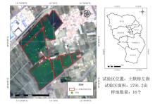
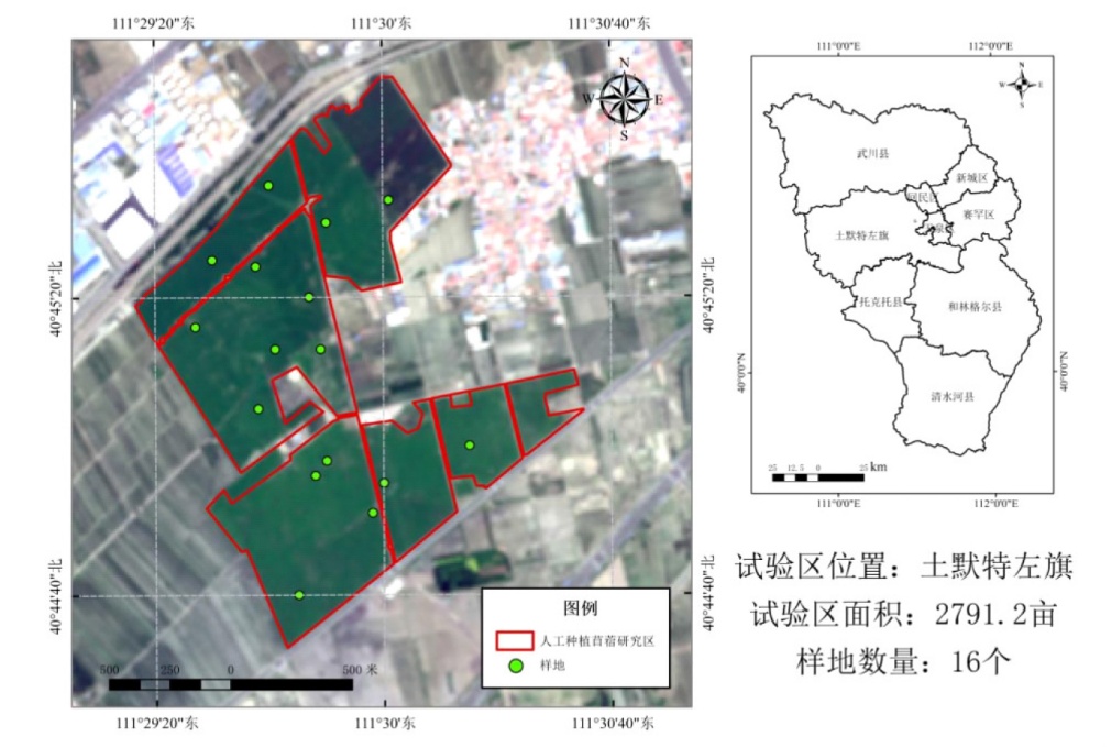
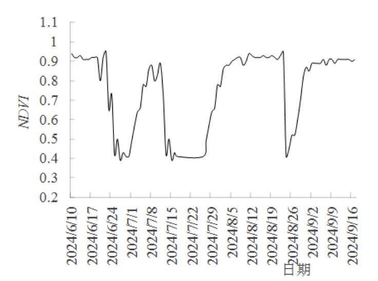
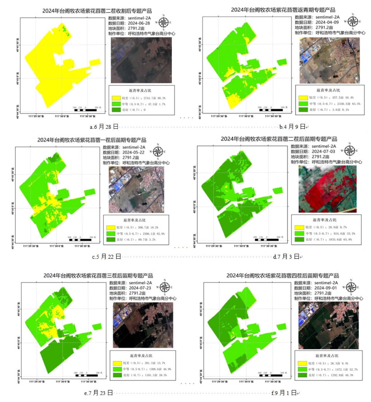
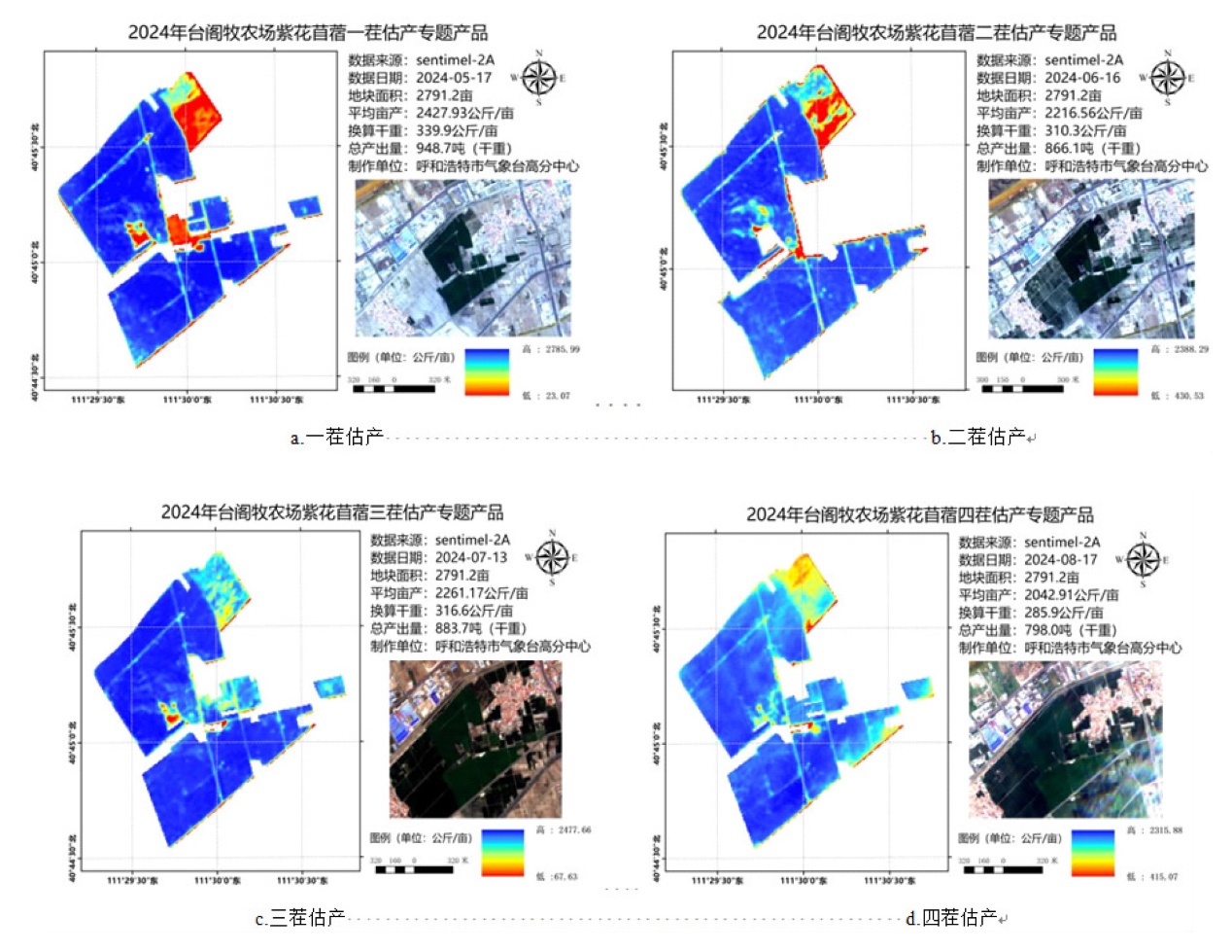
本研究旨在提升苜蓿返青期识别效率及产量估算的准确性,同时降低人工调查的成本。本研究以内蒙古土默特左旗台阁牧苜蓿种植基地为研究区,利用欧洲航天局哨兵二号卫星数据,结合人工观测数据,评估了卫星遥感技术在苜蓿返青识别及产量估算中的可用性和准确性。采用归一化植被指数(NDVI)差值加和法进行返青识别提取,利用NDVI幂函数模型进行苜蓿产量估算。结果表明:在2024年研究区5次返青期(含苗期)的遥感识别结果均符合农业气象观测规范中普遍返青期的标准,实现了准确预测;在4次刈割的产量估算中,遥感模型均能有效预测产量,且对全年总产的预测准确率显著高于单次刈割的预测值,高达88.4%。该研究证实,所提出的返青期识别和产量估算方法能够有效地应用于与试验区环境条件类似的人工种植苜蓿地块中,从而提高调查工作效率,更好地服务于相关企业与农户,并为政府部门及相关单位提供科学的决策依据。

关键词: 人工种植苜蓿, 返青期, 估产, 卫星遥感, 归一化植被指数, 呼和浩特市

Abstract:

To reduce the consumption of human and material resources, and to improve the efficiency of identifying the green-up period of alfalfa and the accuracy of yield estimation through satellite remote sensing, using the data from the European Space Agency Sentinel-2, and the Taigemu alfalfa planting base in Tumd Left Banner, Inner Mongolia was used as the research area to study the usability and accuracy of satellite remote sensing in identifying the green-up period and estimating yields on the basis of comparing the actual situation with manual observations. The identification and extraction of green-up was carried out by using the sum of the differences of the normalized vegetation index (NDVI). The yield estimation of alfalfa was carried out using the NDVI power function model. The results showed that the remote sensing methods for the five green-up periods (include seedling stage) in 2024 all met the common green-up period conditions stipulated in the observation norms and could make accurate predictions. In all four mowing yield estimates, the yield could be predicted efficiently, and the prediction accuracy rate for the total annual yield was higher than that of a single prediction, reaching as high as 88.4%. It indicates that the methods used in this study for identifying the green-up period and estimating the yield can be extended and applied to artificial alfalfa plots with an environment similar to that of the experimental area, improving the efficiency of the investigation work, better serving relevant enterprises and farmers, and providing decision-making basis for government departments and related units.

Key words: artificial alfalfa cultivation, the green-up period, yield estimation, satellite remote sensing, normalized difference vegetation index (NDVI), Hohhot