欢迎访问《中国农学通报》,
中国农学通报 ›› 2021, Vol. 37 ›› Issue (19): 134-142.doi: 10.11924/j.issn.1000-6850.casb2020-0229
所属专题: 油料作物
王军1( ), 姜芸2()
收稿日期:2020-07-01
修回日期:2020-09-09
出版日期:2021-07-05
发布日期:2021-07-29
通讯作者:
姜芸
作者简介:王军,男,1979年出生,山东人,高级工程师,硕士,主要从事GIS、遥感、无人机开发与应用研究。通信地址:150080 哈尔滨市南岗区测绘路32号,E-mail: 基金资助:
Wang Jun1(), Jiang Yun2()
Received:2020-07-01
Revised:2020-09-09
Online:2021-07-05
Published:2021-07-29
Contact:
Jiang Yun
摘要:
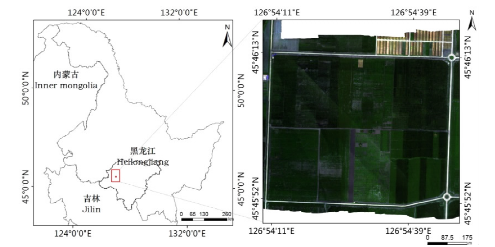
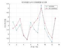
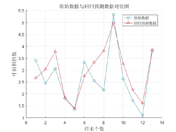
为给大豆科学管理提供基础数据,利用无人机多光谱遥感数据实现对大豆叶面积指数(LAI)的反演估值。从多种光谱植被指数中选出与LAI相关性较好的5种指数,分析探讨在田块尺度上,适用于东北地区的大豆叶面积指数的低空无人机遥感反演模型。结合田间实测LAI数据及模型精度及拟合效果,NDVI模型精度较好,但拟合效果较差,其余4种植被指数模型精度和拟合效果较好,拟合效果R2均达到了0.6以上;支持向量机模型决定系数R2达到0.688,均方根误差达0.016,具有更好的预测能力。2种模型均表明无人机多光谱遥感系统可以快速反演田间大豆叶面积指数,在指导精准农业生产方面具有实用意义。
中图分类号:
王军, 姜芸. 基于无人机多光谱遥感的大豆叶面积指数反演[J]. 中国农学通报, 2021, 37(19): 134-142.
Wang Jun, Jiang Yun. Inversion of Soybean Leaf Area Index Based on UAV Multispectral Remote Sensing[J]. Chinese Agricultural Science Bulletin, 2021, 37(19): 134-142.

| 参数 | 数值 |
|---|---|
| 质量 | 180 g |
| 尺寸 | 12.1 cm×6.6 cm×4.6 cm |
| 外部电源 | 5.0 V DC,4 W(8 W峰值) |
| 光谱波段 | 蓝色,绿色,红色,红色边缘,近红外(全球快门,窄带) |
| RGB颜色输出 | 3.6 MP(全局快门,与所有波段对齐 |
| 地面采样距离(GSD) | 每像素8 cm(每带)120 m AGL |
| 捕获速率 | 每秒捕获1次(所有波段),12位RAW |
| 接口 | 串行、以太网、WiFi、外部触发器、GPS |
| 视野 | 47.2°HFOV |
| 参数 | 数值 |
|---|---|
| 质量 | 180 g |
| 尺寸 | 12.1 cm×6.6 cm×4.6 cm |
| 外部电源 | 5.0 V DC,4 W(8 W峰值) |
| 光谱波段 | 蓝色,绿色,红色,红色边缘,近红外(全球快门,窄带) |
| RGB颜色输出 | 3.6 MP(全局快门,与所有波段对齐 |
| 地面采样距离(GSD) | 每像素8 cm(每带)120 m AGL |
| 捕获速率 | 每秒捕获1次(所有波段),12位RAW |
| 接口 | 串行、以太网、WiFi、外部触发器、GPS |
| 视野 | 47.2°HFOV |
| 参数 | 参数值 |
|---|---|
| 型号 | LI-COR LAI-2200C |
| 测量范围 | 0~2700 μmol/(m2·s) |
| 尺寸 | 63.8 cm (L)×2.9 cm (W)×2.9 cm (D) |
| 水平位置准确度 | 2.5 m CEP |
| 质量 | 0.845 kg |
| 植物叶面积指数测量仪 | 用于320~490 nm波段内的光合有效辐射测量 |
| 参数 | 参数值 |
|---|---|
| 型号 | LI-COR LAI-2200C |
| 测量范围 | 0~2700 μmol/(m2·s) |
| 尺寸 | 63.8 cm (L)×2.9 cm (W)×2.9 cm (D) |
| 水平位置准确度 | 2.5 m CEP |
| 质量 | 0.845 kg |
| 植物叶面积指数测量仪 | 用于320~490 nm波段内的光合有效辐射测量 |
| 参数 | 参数值 |
|---|---|
| 传感器输入 | 1个与主机相连的6针接口 |
| 内存 | 1 MB闪存(文件存储) |
| 电池持续时间 | 典型操作时间为180 h |
| 辐射阻隔率 | 在490~650 nm之间的辐射>99%被阻隔 |
| 感应波长范围 | 320~490 nm |
| 遮盖帽 | 方位角覆盖0°、10°、45°、90°、180°和270°象限 |
| 散射帽 | 在测量天空散射校正属性时遮盖镜头用 |
| 参数 | 参数值 |
|---|---|
| 传感器输入 | 1个与主机相连的6针接口 |
| 内存 | 1 MB闪存(文件存储) |
| 电池持续时间 | 典型操作时间为180 h |
| 辐射阻隔率 | 在490~650 nm之间的辐射>99%被阻隔 |
| 感应波长范围 | 320~490 nm |
| 遮盖帽 | 方位角覆盖0°、10°、45°、90°、180°和270°象限 |
| 散射帽 | 在测量天空散射校正属性时遮盖镜头用 |
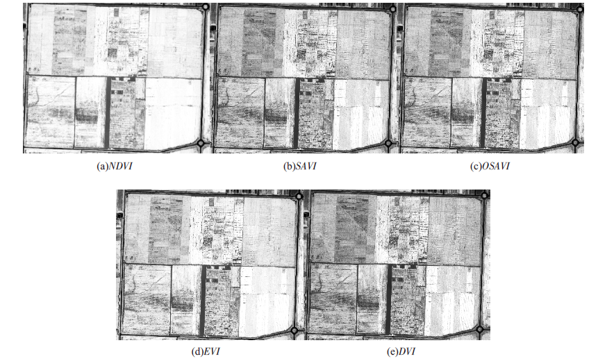
| 植被指数 | 计算公式 | 参考文献 |
|---|---|---|
| NDVI | (ρNIR-ρR)/(ρNIR+ρR) | Rouse等[ |
| DVI | (ρNIR-ρR) | Jordan [ |
| SAVI | (1+0.5)(ρNIR-ρR)/(ρNIR+ρR+0.5) | Huete [ |
| OSAVI | (1+0.16)(ρNIR-ρR)/(ρNIR+ρR+0.16) | Jordan等[ |
| EVI | 2.5(ρNIR-ρR)/(ρNIR+0.6ρB+1) | Huete等[ |
| 植被指数 | 计算公式 | 参考文献 |
|---|---|---|
| NDVI | (ρNIR-ρR)/(ρNIR+ρR) | Rouse等[ |
| DVI | (ρNIR-ρR) | Jordan [ |
| SAVI | (1+0.5)(ρNIR-ρR)/(ρNIR+ρR+0.5) | Huete [ |
| OSAVI | (1+0.16)(ρNIR-ρR)/(ρNIR+ρR+0.16) | Jordan等[ |
| EVI | 2.5(ρNIR-ρR)/(ρNIR+0.6ρB+1) | Huete等[ |

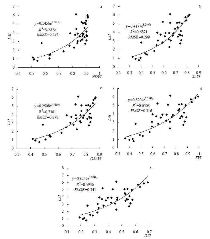
| 统计量 | NDVI | SAVI | OSAVI | EVI | DVI |
|---|---|---|---|---|---|
| R | 0.858** | 0.829** | 0.854** | 0.806** | 0.770** |
| R2 | 0.737 | 0.687 | 0.730 | 0.650 | 0.593 |
| RMSE | 0.274 | 0.299 | 0.278 | 0.316 | 0.341 |
| 统计量 | NDVI | SAVI | OSAVI | EVI | DVI |
|---|---|---|---|---|---|
| R | 0.858** | 0.829** | 0.854** | 0.806** | 0.770** |
| R2 | 0.737 | 0.687 | 0.730 | 0.650 | 0.593 |
| RMSE | 0.274 | 0.299 | 0.278 | 0.316 | 0.341 |


| [1] |
Chen J M, Cihlar J. Retrieving leaf area index of boreal conier forests using LandsatTM images[J]. Remote Sensing of Environment, 1996, 55(2):153-162.
doi: 10.1016/0034-4257(95)00195-6 URL |
| [2] | 李长春, 牛庆林, 杨贵军, 等. 基于无人机数码影像的大豆育种材料叶面积指数估测[J]. 农业机械学报, 2017, 48(8):147-158. |
| [3] | 张彩霞, 付桢. 国际背景下中国大豆的生产困境分析与对策[J]. 河北经贸大学学报:综合版, 2020, 20(4):73-78. |
| [4] | 阎广建, 胡容海, 罗京辉, 等. 叶面积指数间接测量方法[J]. 遥感学报, 2016, 20(5):958-978. |
| [5] |
Alonzo M, Bookhagen B, McFadden J P, et al. Mapping urban forest leaf area index with airborne lidar using penetration metrics and allometr[J]. Remote Sensing of Environment, 2015, 162(2):141-153.
doi: 10.1016/j.rse.2015.02.025 URL |
| [6] | 贺佳, 郭燕, 王利军, 等. 基于作物生长监测诊断仪的玉米LAI监测模型研究[J]. 农业机械学报, 2019, 50(12):187-194. |
| [7] |
Liu J, Pattey E, G Jégo. Assessment of vegetation indices for regional crop green LAI estimation from Landsat images over multiple growing seasons[J]. Remote Sensing of Environment, 2012, 123:347-358.
doi: 10.1016/j.rse.2012.04.002 URL |
| [8] | 阎广建, 胡容海, 罗京辉, 等. 叶面积指数间接测量方法[J]. 遥感学报, 2016, 20(5):958-978. |
| [9] | 蒙继华, 吴炳方, 李强子. 全国农作物叶面积指数遥感估算方法[J]. 农业工程学报, 2007, 23(2):160-167. |
| [10] | 陈雪洋, 蒙继华, 杜鑫, 等. 基于环境星CCD数据的冬小麦叶面积指数遥感监测模型研究[J]. 国土资源遥感, 2010(2):55-58,62. |
| [11] | 侯学会, 王猛, 梁守真, 等. 基于GF-1数据的冬小麦不同生育期叶面积指数反演[J]. 山东农业科学, 2018, 50(11):148-153. |
| [12] |
Yue J, Yang G, Li C, et al. Estimation of Winter Wheat Above-Ground Biomass Using Unmanned Aerial Vehicle-Based Snapshot Hyperspectral Sensor and Crop Height Improved Models[J]. Remote Sensing, 2017, 9(7):708.
doi: 10.3390/rs9070708 URL |
| [13] |
Feng W, Zhang H Y, Zhang Y S, et al. Remote detection of canopy leaf nitrogen concentration in winter wheat by using water resistance vegetation indices from in-situ hyperspectral data[J]. Field Crops Research, 2016, 198:238-246.
doi: 10.1016/j.fcr.2016.08.023 URL |
| [14] | 姚雄, 余坤勇, 杨玉洁, 等. 基于随机森林模型的林地叶面积指数遥感估算[J]. 农业机械学报, 2017, 48(5):159-166. |
| [15] |
Gray J, Song C. Mapping leaf area index using spatial, spectral, and temporal information from multiple sensors[J]. Remote Sensing of Environment, 2012, 119:173-183.
doi: 10.1016/j.rse.2011.12.016 URL |
| [16] | 孙诗睿, 赵艳玲, 王亚娟, 等. 基于无人机多光谱遥感的冬小麦叶面积指数反演[J]. 中国农业大学学报, 2019, 24(11):51-58. |
| [17] | 韩文霆, 彭星硕, 张立元, 等. 基于多时相无人机遥感植被指数的夏玉米产量估算[J]. 农业机械学报, 2020, 51(1):148-155. |
| [18] | 陶惠林, 冯海宽, 杨贵军, 等. 基于无人机成像高光谱影像的冬小麦LAI估测[J]. 农业机械学报, 2020, 51(1):176-187. |
| [19] | 林卉, 梁亮, 张连蓬, 等. 基于支持向量机回归算法的小麦叶面积指数高光谱遥感反演[J]. 农业工程学报, 2013, 29(11):139-146. |
| [20] |
Yue J, Feng H, Jin X, et al. A Comparison of Crop Parameters Estimation Using Images from UAV-Mounted Snapshot Hyperspectral Sensor and High-Definition Digital Camera[J]. Remote Sensing, 2018, 10(7):1138.
doi: 10.3390/rs10071138 URL |
| [21] | 高林, 杨贵军, 王宝山, 等. 基于无人机遥感影像的大豆叶面积指数反演研究[J]. 中国生态农业学报, 2015, 23(7):868-876. |
| [22] | 张东彦, Coburn C, 赵晋陵, 等. 基于多角度成像数据的大豆冠层叶绿素密度反演[J]. 农业机械学报, 2013, 44(2):205-213. |
| [23] | Rouse J W. Monitoring vegetation systems in the Great Plains with ERTS[C]. NASA. Goddard Space Flight Center 3 d ERTS-1 Symp, 1974. |
| [24] | Jordan C F. Derivation of leaf-area index from quality of light on the forest floor[J]. Ecology. 1969: 663-666. |
| [25] |
Huete A R. A soil-adjusted vegetation index (SAVI)[J]. Remote Sensing of Environment, 1988, 25(3):295-309.
doi: 10.1016/0034-4257(88)90106-X URL |
| [26] |
Huete A, Didan K, Miura T, et al. Overview of the radiometric and biophysical performance of the MODIS vegetation indices[J]. Remote Sensing of Environment, 2002, 83(1):195-213.
doi: 10.1016/S0034-4257(02)00096-2 URL |
| [27] | 陆国政, 李长春, 杨贵军, 等. 基于成像高光谱仪的大豆叶面积指数反演研究[J]. 大豆科学, 2016, 35(4):599-608. |
| [28] | 刘佳, 王利民, 滕飞, 等. 玉米大豆轮作遥感监测技术研究[J]. 中国农学通报, 2017, 33(8):144-153. |
| [29] | 牛庆林, 冯海宽, 杨贵军, 等. 基于无人机数码影像的玉米育种材料株高和LAI监测[J]. 农业工程学报, 2018, 34(5):73-82. |
| [30] | 高林, 杨贵军, 于海洋, 等. 基于无人机高光谱遥感的冬小麦叶面积指数反演[J]. 农业工程学报, 2016, 32(22):113-120. |
| [31] | 张漫, 苗艳龙, 仇瑞承, 等. 基于车载三维激光雷达的玉米叶面积指数测量[J]. 农业机械学报, 2019, 50(6):12-21. |
| [32] | Omar V D, Zaman-Allah M A, Benhildah M, et al. A Novel Remote Sensing Approach for Prediction of Maize Yield Under Different Conditions of Nitrogen Fertilization[J]. Frontiers in Plant Science, 2016, 7. |
| [1] | 孙瑜, 张永梅, 武玉军. 基于粒子群算法和支持向量机的黄花菜叶部病害识别[J]. 中国农学通报, 2022, 38(8): 135-140. |
| [2] | 周小红. 基于多元回归分析的农作物产量估测模型研究[J]. 中国农学通报, 2022, 38(8): 152-156. |
| [3] | 田艺心, 高凤菊, 曹鹏鹏, 高祺. 黄淮海夏大豆干物质积累、转运及产量对播期的响应特征[J]. 中国农学通报, 2022, 38(6): 20-25. |
| [4] | 余忠浩, 周伟, 李志刚, 李资文, 贾娟霞, 周亚星. 2002—2021年内蒙古自治区大豆主要性状变化分析及综合评价[J]. 中国农学通报, 2022, 38(34): 14-21. |
| [5] | 汪欢欢, 杨琴, 蒲红梅, 何进, 程华, 韩敏, 赵学春, 王志伟, 金宝成. 照片样线法大豆植被覆盖度测量精度分析[J]. 中国农学通报, 2022, 38(32): 111-118. |
| [6] | 胡馨月, 孙倩, 古丽古丽·灭迪力哈孜. 新疆布尔津县五年间归一化植被指数时空演变[J]. 中国农学通报, 2022, 38(32): 6-11. |
| [7] | 娄仲山. 高寒草原针茅牧草花期物候变化特征及其影响因子分析[J]. 中国农学通报, 2022, 38(29): 129-134. |
| [8] | 陈斌. 基于无人机影像的林地单株立木自动化提取研究——以丹霞山湿地保护区为例[J]. 中国农学通报, 2022, 38(29): 152-158. |
| [9] | 朱喜霞, 郑玉珍, 王海红, 黄保, 平西栓, 刘天学, 赵霞, 李毓珍. 机械化条件下“豆玉”不同行距配置和减肥对作物产量及大豆光合特性的影响[J]. 中国农学通报, 2022, 38(29): 16-21. |
| [10] | 崔燕华, 周婷婷, 沈煜洋, 陈利, 蔺国仓, 杨安沛, 张航, 雷钧杰, 李广阔, 高海峰. 小型植保无人机超低量喷雾对荒漠绿洲麦区小麦白粉病的防治效果[J]. 中国农学通报, 2022, 38(27): 147-150. |
| [11] | 郭文, 代希茜, 莫楠, 张应青, 余晨, 田江, 耿智德, 李露. 东盟国家大豆种植及其大豆产品进出口结构分析[J]. 中国农学通报, 2022, 38(23): 156-164. |
| [12] | 高中超, 孙磊, 王丽华, 杜春影, 张利国, 张久明, 王伟, 谷维. 土壤中不同含量Cd2+对大麻、大豆幼苗生育的影响[J]. 中国农学通报, 2022, 38(22): 89-92. |
| [13] | 王汝毅, 王秀娟, 高磊, 岳训. 多旋翼授粉无人机的作业航迹规划[J]. 中国农学通报, 2022, 38(18): 159-164. |
| [14] | 孙锡鹏, 李琪, 乔云发, 胡正华, 张徐莹, 刘园园. 增温及干旱对海伦地区大豆生长发育的影响[J]. 中国农学通报, 2022, 38(15): 27-33. |
| [15] | 马文舟, 陈妍妍, 吴洪生, 王晓云, 孙倩, 丁军, 李妍慧, 刘政, 蔡云彤, 徐金益, 张金福, 殷文, 张绪美, 许建华. 利用热镀锌厂锌尘生产液体有机锌肥的研究[J]. 中国农学通报, 2022, 38(15): 91-97. |
| 阅读次数 | ||||||
|
全文 |
|
|||||
|
摘要 |
|
|||||