| [1] |
Ren G Y, Ding Y H, Zhao Z C, et al.Recent Progress in Studies of Climate Change in China[J].Advances in Atmospheric Sciences,2012,29(05):958-977.
|
| [2] |
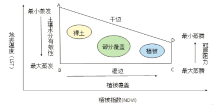
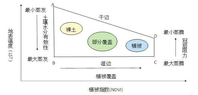
彭擎,王让会,蒋烨林,等. 植被-地温指数(NDVI-LST)在新疆干旱监测中的适应性[J/OL].生态学报,2018(13):1-9.
|
| [3] |
郭铌,管晓丹.植被状况指数的改进及在西北干旱监测中的应用[J].地球科学进展,2007(11):1160-1168.
|
| [4] |
龚艳冰,张继国,刘高峰,等.基于SPI指数与R/S分析的曲靖市干旱特征研究[J].干旱地区农业研究,2015,33(03):273-277.
|
| [5] |
Kogon F N.Remote sensing ofweather impact S on vegetation in non-homogeneous areas[J].International Joumal of Remote Sensing,1990,11:1405-1420.
|
| [6] |
Jackson R D, Idso S B, Reginato R J, et al.Canopy temperature as a crop water stress indicator[J].Water Resources Research,1981,17(4):1133-1138
|
| [7] |
Price J C.Using spatial context in satellite data to infer regional scale evapotranspiration[J].IEEE Transactions on Geoscience and Remote Sensing,1990,28:940-948.
|
| [8] |
Kimura R.Estimation ofmoisture availability over the Liudaogou river basin ofthe Loess Plateau using new indices with surface temperature[J].Journal of Environments,2007,10;10-16.
|
| [9] |
刘丽,周颖,杨凤,宋国强.用遥感植被供水指数监测贵州干旱[J].贵州气象,1998(06):17-21.
|
| [10] |
李坤. 基于RS和GIS的重庆伏旱研究[D].重庆:重庆师范大学,2010:8-12
|
| [11] |
曹言,王杰,李竹芬,等. 基于VSWI法的云南省土壤水分反演研究[J].中国农村水利水电,2017(04):22-27.
|
| [12] |
龙晓敏,王龙,杨蕊,等. 基于温度植被干旱指数的云南干旱遥感监测[J].中国农村水利水电,2012(11):136-139,144.
|
| [13] |
曹影,胡文庆,颜培东.基于温度植被干旱指数(TVDI)的云南干旱遥感监测[J].工程勘察,2016,44(01):69-73.
|
| [14] |
王琳. 基于SPEI和RDI的曲靖大型灌区干旱趋势研究[J].安徽农业科学,2018,46(07):165-169.
|
| [15] |
蒋先林,杨鲁生,丁云双,等.低纬高原马铃薯脱毒种薯标准化生产技术[J].安徽农业科学,2013,41(35):13506-13509.
|
| [16] |
赵敏,胡文英.综合干旱评价方法在云南省的适用性研究[J].云南师范大学学报:自然科学版,2016,36(06):69-75.
|
| [17] |
张学艺. 几种最新干旱监测模型在西北干旱遥感监测应用中的对比研究——以宁夏为例[A].中国气象学会农业气象与生态学委员会,南京信息工程大学,中国农学会农业气象分会,中国农科院环境与可持续发展研究所.第26届中国气象学会年会农业气象防灾减灾与粮食安全分会场论文集[C].中国气象学会农业气象与生态学委员会,南京信息工程大学,中国农学会农业气象分会,中国农科院环境与可持续发展研究所:中国气象学会,2009:12.
|
| [18] |
王君. 基于MODIS产品的青海省干旱监测[D].长沙:中南大学,2014:10-16.
|
| [19] |
魏杰. 青海省东部农业区干旱遥感监测及预警研究[D].陕西杨凌:西北农林科技大学,2016:36-37.
|
| [20] |
齐述华. 干旱监测遥感模型和中国干旱时空分析[D].北京:中国科学院研究生院遥感应用研究所,2004:80-90.
|
 ), 王晓飞1(