欢迎访问《中国农学通报》,
中国农学通报 ›› 2020, Vol. 36 ›› Issue (8): 111-118.doi: 10.11924/j.issn.1000-6850.casb19010104
任艳中1, 王弟2( ), 李轶涛2, 王晓军3
收稿日期:2019-01-18
修回日期:2019-03-12
出版日期:2020-03-15
发布日期:2020-03-10
通讯作者:
王弟
作者简介:任艳中,男,1994年出生,山西中阳人,在读硕士,研究方向:森林资源监测。通信地址:030006 山西省太原市坞城路 山西大学黄土高原研究所,Tel:0351-7010700,E-mail:15135478341@163.com。
基金资助:
Ren Yanzhong1, Wang Di2(), Li Yitao2, Wang Xiaojun3
Received:2019-01-18
Revised:2019-03-12
Online:2020-03-15
Published:2020-03-10
Contact:
Di Wang
摘要:
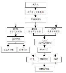
为了给森林资源监测中无人机遥感的应用研究提供依据,归纳了无人机遥感用于森林资源监测的技术流程,总结了在森林资源监测中常用的传感器类型,分析了无人机遥感在森林病虫害监测、林分树高测定、森林冠层结构与属性测定、树种组成识别、森林生物量测定中的应用和表现。得出通过无人机遥感搭载各种类型的传感器来收集森林信息,将是未来森林资源监测的一个重要方向;无人机遥感数字化、信息化、自动化提取森林结构参数将是无人机遥感用于森林资源监测中的发展趋势;此外,无人机遥感搭载多样化传感器以及传感器的小型化、商业化将进一步促进森林资源的精确监测。
中图分类号:
任艳中, 王弟, 李轶涛, 王晓军. 无人机遥感在森林资源监测中的应用研究进展[J]. 中国农学通报, 2020, 36(8): 111-118.
Ren Yanzhong, Wang Di, Li Yitao, Wang Xiaojun. Applications of Unmanned Aerial Vehicle-based Remote Sensing in Forest Resources Monitoring: A Review[J]. Chinese Agricultural Science Bulletin, 2020, 36(8): 111-118.

| 传感器 | 产出数据 | 应用 |
|---|---|---|
| 高光谱传感器 | 全波段光谱信息 | 森林病虫害监测[ |
| 可见光数码照相机 | 数字正射影像(DOM) 数字表面模型(DSM) | 森林病虫害监测[ |
| 多光谱传感器 | 多波段光谱信息 | 森林病虫害监测[ |
| 热红外相机 | 温度图谱 | 森林病虫害监测[ |
| 激光雷达 | 点云,数字表面模型(DSM), 数字地面模型(DTM) | 森林冠层结构与属性测定[ |
| 传感器 | 产出数据 | 应用 |
|---|---|---|
| 高光谱传感器 | 全波段光谱信息 | 森林病虫害监测[ |
| 可见光数码照相机 | 数字正射影像(DOM) 数字表面模型(DSM) | 森林病虫害监测[ |
| 多光谱传感器 | 多波段光谱信息 | 森林病虫害监测[ |
| 热红外相机 | 温度图谱 | 森林病虫害监测[ |
| 激光雷达 | 点云,数字表面模型(DSM), 数字地面模型(DTM) | 森林冠层结构与属性测定[ |
| [1] | Pajares G . Overview and Current Status of Remote Sensing Applications Based on Unmanned Aerial Vehicles (UAVs)[J]. Photogrammetric Engineering & Remote Sensing, 2015,81(4):281-330. |
| [2] | Boyd D S, Danson F M . Satellite Remote Sensing of Forest Resources:Three Decades of Research Development[J]. Progress in Physical Geography, 2005,29(1):1-26. |
| [3] | Casbeer D W, Kingston D B, Beard R W , et al. Cooperative Forest Fire Surveillance Using a Team of Small Unmanned Air Vehicles[J]. International Journal of Systems Science, 2006,37(6):351-360. |
| [4] | Mayaux P, Holmgren P, Achard F , et al. Tropical Forest Cover Change in the 1990s and Options for Future Monitoring[J]. Philosophical Transactions of the Royal Society of London B:Biological Sciences, 2005,360:373-384. |
| [5] | Sullivan J M . Evolution or Revolution? The Rise of UAVs[J]. IEEE Technology and Society Magazine, 2006,25(3):43-49. |
| [6] | Tang L, Shao G . Drone Remote Sensing for Forestry Research and Practices[J]. Journal of Forestry Research, 2015,26(4):791-797. |
| [7] | Matese A, Toscano P, Di Gennaro S F , et al. Intercomparison of UAV, Aircraft and Satellite Remote Sensing Platforms for Precision Viticulture[J]. Remote Sensing, 2015,7(3):2971-2990. |
| [8] | 臧克, 孙永华, 李京 , 等. 微型无人机遥感系统在汶川地震中的应用[J]. 自然灾害学报, 2010,19(3):162-166. |
| [9] | Hyyppä J, Hyyppä H, Leckie D , et al. Review of methods of small-footprint airborne laser scanning for extracting forest inventory data in boreal forests[J]. International Journal of Remote Sensing, 2008,29(5):1339-1366. |
| [10] | 谭炳香, 李增元, 陈尔学 , 等. 高光谱遥感森林信息提取研究进展[J]. 林业科学研究, 2008,21(S):105-111. |
| [11] | Näsi R, Honkavaara E, Lyytikäinen-Saarenmaa P , et al. Using UAV-based Photogrammetry and Hyperspectral Imaging for Mapping Bark Beetle Damage at Tree-Level[J]. Remote Sensing, 2015,7(11):15467-15493. |
| [12] | Kotsiantis S B, Zaharakis I, Pintelas P . Supervised Machine Learning: A Review of Classification Techniques[J]. Emerging artificial intelligence applications in computer engineering, 2007,160:3-24. |
| [13] | Soloviov O . Geospatial Assessment of Pest-induced Forest Damage Through the Use of UAV-based NIR Imaging and GI-technology[D]. Lisboa: Universidade Nova de Lisboa, 2014. |
| [14] | Yuan Y, Hu X . Random Forest and Objected-based Classification for Forest Pest Extraction from UAV Aerial Imagery[J]. ISPRS-International Archives of the Photogrammetry, Remote Sensing and Spatial Information Sciences, 2016, XLI-B1:1093-1098. |
| [15] | Dash J P, Watt M S, Pearse G D , et al. Assessing Very High Resolution UAV Imagery for Monitoring Forest Health During A Simulated Disease Outbreak[J]. ISPRS Journal of Photogrammetry and Remote Sensing, 2017,131:1-14. |
| [16] | Wen A, Zheng J, Chen M , et al. Spatial Distribution of Rodent Pests in Desert Forest Based on UAV Remote Sensing[C]. Piscataway,NJ:IEEE, 2016: 1804-1807. |
| [17] | Smigaj M, Gaulton R, Barr S L , et al. UAV-borne Thermal Imaging for Forest Health Monitoring: Detection of Disease-induced Canopy Temperature Increase[J]. The International Archives of the Photogrammetry, Remote Sensing and Spatial Information Sciences, 2015, XL-3/W3:349-354. |
| [18] | Chen B, Li Z, Pang Y , et al. Forest Height Estimation Based on UAV Lidar Simulated Waveform[C]. Piscataway,NJ:IEEE, 2017: 2859-2862. |
| [19] | 杨坤, 赵艳玲, 张建勇 , 等. 利用无人机高分辨率影像进行树木高度提取[J]. 北京林业大学学报, 2017,39(8):17-23. |
| [20] | 曹明兰, 张力小, 王强 . 无人机遥感影像中行道树信息快速提取[J]. 中南林业科技大学学报, 2016,36(10):89-93. |
| [21] | 张煜星, 王雪军, 刘明博 . 基于无人机遥感影像的DSM及遥感数据林分平均高提取[J]. 林业资源管理, 2017(2):23-27,52. |
| [22] | Birdal A C, Avdan U, Türk T . Estimating Tree Heights with Images from an Unmanned Aerial Vehicle[J]. Geomatics Natural Hazards and Risk, 2017,8(2):1144-1156. |
| [23] | Zarco-Tejada P J, Diaz-Varela R, Angileri V , et al. Tree Height Quantification Using Very High Resolution Imagery Acquired from an Unmanned Aerial Vehicle (UAV) and Automatic 3D Photo-reconstruction Methods[J]. European Journal of Agronomy, 2014,55:89-99. |
| [24] | 许子乾, 曹林, 阮宏华 , 等. 集成高分辨率UAV影像与激光雷达点云的亚热带森林林分特征反演[J]. 植物生态学报, 2015,39(7):694-703. |
| [25] | Chianucci F, Disperati L, Guzzi D , et al. Estimation of Canopy Attributes in Beech Forests Using True Colour Digital Images From a Small Fixed-wing UAV[J]. International Journal of Applied Earth Observation and Geoinformation, 2016,47:60-68. |
| [26] | Tian J, Wang L, Li X , et al. Comparison of UAV and WorldView-2 Imagery for Mapping Leaf Area Index of Mangrove Forest[J]. International Journal of Applied Earth Observation and Geoinformation, 2017,61:22-31. |
| [27] | Zhang J, Hu J, Lian J , et al. Seeing the Forest from Drones: Testing the Potential of Lightweight Drones as a tool for Long-term Forest Monitoring[J]. Biological Conservation, 2016,198:60-69. |
| [28] | 刘文萍, 仲亭玉, 宋以宁 . 基于无人机图像分析的树木胸径预测[J]. 农业工程学报, 2017,33(21):99-104. |
| [29] | 王枚梅, 林家元, 林沂 , 等. 基于无人机可见光影像的亚高山针叶林树冠参数信息自动提取[J]. 林业资源管理, 2017(4):82-88. |
| [30] | Zahawi R A, Dandois J P, Holl K D , et al. Using Lightweight Unmanned Aerial Vehicles to Monitor Tropical Forest Recovery[J]. Biological Conservation, 2015,186:287-295. |
| [31] | Mohan M, Silva C, Klauberg C , et al. Individual Tree Detection from Unmanned Aerial Vehicle (UAV) Derived Canopy Height Model in An Open Canopy Mixed Conifer Forest[J]. Forests, 2017,8(9):340. |
| [32] | 曾庆伟, 武红敢 . 基于高光谱遥感技术的森林树种识别研究进展[J]. 林业资源管理, 2009(5):109-114. |
| [33] | Sankey T, Donager J, McVay J , et al. UAV Lidar and Hyperspectral Fusion for Forest Monitoring in the Southwestern USA[J]. Remote Sensing of Environment, 2017,195:30-43. |
| [34] | Nevalainen O, Honkavaara E, Tuominen S , et al. Individual Tree Detection and Classification with UAV-based Photogrammetric Point Clouds and Hyperspectral Imaging[J]. Remote Sensing, 2017,9(3):185. |
| [35] | Samiappan S, Turnage G, Hathcock L , et al. Classifying Common Wetland Plants Using Hyperspectral Data to Identify Optimal Spectral Bands for Species Mapping Using a Small Unmanned Aerial Systems-A Case Study[C]. Piscataway,NJ:IEEE, 2017: 5924-5927. |
| [36] | Cao J, Leng W, Liu K , et al. Object-based Mangrove Species Classification Using Unmanned Aerial Vehicle Hyperspectral Images and Digital Surface Models[J]. Remote Sensing, 2018,10(1):89. |
| [37] | 刘峰, 谭畅, 雷丕锋 . 中亚热带森林单木地上生物量的机载激光雷达估测[J]. 应用生态学报, 2014,25(11):3229-3236. |
| [38] | Otero V, Van De Kerchove R, Satyanarayana B , et al. Managing Mangrove Forests from the Sky:Forest Inventory Using Field Data and Unmanned Aerial Vehicle(UAV) Imagery in the Matang Mangrove Forest Reserve, Peninsular Malaysia[J]. Forest Ecology and Management, 2018,411:35-45. |
| [39] | 何游云 . 无人机遥感估测林木地上生物量的研究[D]. 北京:北京林业大学, 2016. |
| [40] | 刘见礼 . 基于无人机立体影像数据的森林结构参数调查研究[D]. 北京:中国科学院大学, 2017. |
| [41] | Guerra-Hernández J, González-Ferreiro E, Monleón V J , et al. Use of Multi-Temporal UAV-Derived Imagery for Estimating Individual Tree Growth in Pinus pinea Stands[J]. Forests, 2017,8(8):300. |
| [42] | Muchiri N, Kimathi S . A Review of Applications and Potential Applications of UAV[C]. Nairobi:Proceedings of Sustainable Research and Innovation Conference, 2016: 280-283. |
| [43] | Salamí E, Barrado C, Pastor E . UAV Flight Experiments Applied to the Remote Sensing of Vegetated Areas[J]. Remote Sensing, 2014,6(11):11051-11081. |
| [44] | 李德仁, 李明 . 无人机遥感系统的研究进展与应用前景[J]. 武汉大学学报:信息科学版, 2014,39(5):505-513. |
| [45] | Pádua L, Vanko J, Hruška J , et al. UAS, Sensors, and Data Processing in Agroforestry: A Review towards Practical Applications[J]. International journal of remote sensing, 2017,38(8-10):2349-2391. |
| [46] | 李祥, 郑淯文, 戴楚彦 , 等. 基于无人机影像的森林信息获取研究进展[J]. 世界林业研究, 2017,30(4):41-46. |
| [47] | Klemas V V . Coastal and Environmental Remote Sensing from Unmanned Aerial Vehicles: An Overview[J]. Journal of Coastal Research, 2015,31(5):1260-1267. |
| [48] | Otsu K, Pla M, Vayreda J , et al. Calibrating the Severity of Forest Defoliation by Pine Processionary Moth with Landsat and UAV Imagery[J]. Sensors, 2018,18(10):3278. |
| [49] | Ota T, Ogawa M, Mizoue N , et al. Forest Structure Estimation from a UAV-based Photogrammetric Point Cloud in Managed Temperate Coniferous Forests[J]. Forests, 2017,8(9):343. |
| [50] | Lehmann J, Nieberding F, Prinz T , et al. Analysis of Unmanned Aerial System-based CIR Images in Forestry-A New Perspective to Monitor Pest Infestation Levels[J]. Forests, 2015,6(12):594-612. |
| [51] | Blaschke T . Object Based Image Analysis for Remote Sensing[J]. ISPRS Journal of Photogrammetry and Remote Sensing, 2010,65(1):2-16. |
| [52] | Torresan C, Berton A, Carotenuto F , et al. Forestry Applications of UAVs in Europe: A Review[J]. International Journal of Remote Sensing, 2017,38(8-10):2427-2447. |
| [53] | Selkowitz D J, Green G, Peterson B , et al. A Multi-sensor Lidar, Multi-spectral and Multi-angular Approach for Mapping Canopy Height in Boreal Forest Regions[J]. Remote Sensing of Environment, 2012,121:458-471. |
| [54] | Fraser B, Congalton R . Issues in Unmanned Aerial Systems (UAS) Data Collection of Complex Forest Environments[J]. Remote Sensing, 2018,10(6):908. |
| [55] | Sanchez-Azofeifa A, Antonio Guzmán J, Campos C A , et al. Twenty-first Century Remote Sensing Technologies Are Revolutionizing the Study of Tropical Forests[J]. Biotropica, 2017,49(5):604-619. |
| [56] | Paneque-Gálvez J, McCall M K, Napoletano B M , et al. Small Drones for Community-based Forest Monitoring:An Assessment of Their Feasibility and Potential in Tropical Areas[J]. Forests, 2014,5(6):1481-1507. |
| [57] | 杨龙, 孙中宇, 唐光良 , 等. 基于微型无人机遥感的亚热带林冠物种识别[J]. 热带地理, 2016,36(5):833-839. |
| [58] | Lisein J, Michez A, Claessens H , et al. Discrimination of Deciduous Tree Species from Time Series of Unmanned Aerial System Imagery[J]. PLOS ONE, 2015,10(11):e141006. |
| [59] | 朱雄斌, 汪小钦, 周小成 . 一种利用可见光波段无人机遥感的林下植被覆盖识别方法[J]. 福州大学学报:自然科学版, 2018,46(6):814-820,838. |
| [60] | Calders K, Newnham G, Burt A , et al. Nondestructive Estimates of Above-ground Biomass Using Terrestrial Laser Scanning[J]. Methods in Ecology and Evolution, 2015,6(2):198-208. |
| [61] | Calderón R, Navas-Cortés J A, Zarco-Tejada P J . Early Detection and Quantification of Verticillium Wilt in Olive Using Hyperspectral and Thermal Imagery Over Large Areas[J]. Remote Sensing, 2015,7(5):5584-5610. |
| [62] | Bareth G, Bendig J, Tilly N , et al. A Comparison of UAV-and TLS-derived Plant Height for Crop Monitoring: Using Polygon Grids for the Analysis of Crop Surface Models (CSMs)[J]. Photogrammetrie-Fernerkundung-Geoinformation, 2016,2016(2):85-94. |
| [63] | Panagiotidis D, Abdollahnejad A, Surový P , et al. Determining Tree Height and Crown Diameter from High-Resolution UAV Imagery[J]. International journal of remote sensing, 2017,38(8-10):2392-2410. |
| [64] | Iizuka K, Yonehara T, Itoh M , et al. Estimating Tree Height and Diameter at Breast Height (DBH) from Digital Surface Models and Orthophotos Obtained with an Unmanned Aerial System for a Japanese Cypress (Chamaecyparis Obtusa) Forest[J]. Remote Sensing, 2017,10(1):13. |
| [65] | Getzin S, Nuske R S, Wiegand K . Using Unmanned Aerial Vehicles (UAV) to Quantify Spatial Gap Patterns in Forests[J]. Remote Sensing, 2014,6(8):6988-7004. |
| [66] | Fritz A, Kattenborn T, Koch B . UAV-based Photogrammetric Point Clouds-Tree Stem Mapping in Open Stands in Comparison to Terrestrial Laser Scanner Point Clouds[J]. International Archives of the Photogrammetry, Remote Sensing and Spatial Information Sciences, 2013, XL-1/W2:141-146. |
| [67] | Wang C, Du H Q, Zhou G M , et al. Retrieval of Crown Closure of Moso Bamboo Forest Using Unmanned Aerial Vehicle (UAV) Remotely Sensed Imagery Based on Geometric-optical Model[J]. Chinese Journal of Applied Ecology, 2015,26(5):1501-1509. |
| [68] | Chisholm R A, Cui J, Lum S K Y , et al. UAV LiDAR for Below-canopy Forest Surveys[J]. Journal of Unmanned Vehicle Systems, 2013,1(1):61-68. |
| [69] | Dandois J P, Ellis E C . High Spatial Resolution Three-dimensional Mapping of Vegetation Spectral Dynamics Using Computer Vision[J]. Remote Sensing of Environment, 2013,136:259-276. |
| [70] | Roşca S, Suomalainen J, Bartholomeus H , et al. Comparing Terrestrial Laser Scanning and Unmanned Aerial Vehicle Structure from Motion to Assess Top of Canopy Structure in Tropical Forests[J]. Interface focus, 2018,8(2):20170038. |
| [71] | Goodbody T R H, Coops N C, Hermosilla T , et al. Assessing the Status of Forest Regeneration Using Digital Aerial Photogrammetry and Unmanned Aerial Systems[J]. International Journal of Remote Sensing, 2018,39(15-16):5246-5264. |
| [72] | Huang H, Li X, Chen C . Individual Tree Crown Detection and Delineation from Very-High-Resolution UAV Images Based on Bias Field and Marker-controlled Watershed Segmentation Algorithms[J]. IEEE Journal of Selected Topics in Applied Earth Observations and Remote Sensing, 2018,11(7):2253-2262. |
| [73] | Inoue T, Nagai S, Yamashita S , et al. Unmanned Aerial Survey of Fallen Trees in a Deciduous Broadleaved Forest in Eastern Japan[J]. PLOS ONE, 2014,9(10):e109881. |
| [74] | Cruzan M B, Weinstein B G, Grasty M R , et al. Small Unmannedaerial Vehicles (Micro-UAVs, Drones) in Plant Ecology[J]. Applications in plant sciences, 2016,4(9):1600041. |
| [75] | Baena S, Moat J, Whaley O , et al. Identifying Species from the Air:UAVs and the Very High Resolution Challenge for Plant Conservation[J]. PLOS ONE, 2017,12(11):e0188714. |
| [76] | Perroy R L, Sullivan T, Stephenson N . Assessing the Impacts of Canopy Openness and Flight Parameters on Detecting a Sub-canopy Tropical Invasive Plant Using a Small Unmanned Aerial System[J]. ISPRS Journal of Photogrammetry and Remote Sensing, 2017,125:174-183. |
| [77] | Tuominen S, Näsi R, Honkavaara E , et al. Tree Species Recognition in Species Rich Area Using Uav-borne Hyperspectral Imagery and Stereo-Photogrammetric Point Cloud[J]. ISPRS-International Archives of the Photogrammetry, Remote Sensing and Spatial Information Sciences, 2017, XLII-3/W3:185-194. |
| [78] | Michez A, Piégay H, Lisein J , et al. Classification of Riparian Forest Species and Health Condition Using Multi-Temporal and Hyperspatial Imagery from Unmanned Aerial System[J]. Environmental monitoring and assessment, 2016,188(3):146. |
| [79] | Garciaruiz F, Sankaran S, Maja J M , et al. Comparison of Two Aerial Imaging Platforms for Identification of Huanglongbing-Infected Citrus Trees[J]. Computers and Electronics in Agriculture, 2013,91:106-115. |
| [80] | Johansen K, Raharjo T, McCabe M . Using Multi-Spectral UAV Imagery to Extract Tree Crop Structural Properties and Assess Pruning Effects[J]. Remote Sensing, 2018,10(6):854 |
| [81] | Smigaj M, Gaulton R, Suarez J C , et al. Use of Miniature Thermal Cameras for Detection of Physiological Stress in Conifers[J]. Remote Sensing, 2017,9(9):957. |
| [82] | Chisholmryan A, Cui J Q, Lumshawn K Y , et al. UAV LiDAR for Below-Canopy Forest Surveys[J]. Journal of Unmanned Vehicle Systems, 2013,1(1):61-68. |
| [83] | Torresan C, Corona P, Scrinzi G , et al. Using Classification Trees to Predict Forest Structure Types from LiDAR Data[J]. Annals of Forest Research, 2016,59(2):281-298. |
| [84] | Guo Q, Su Y, Hu T , et al. An Integrated UAV-borne Lidar System for 3D Habitat Mapping in Three Forest Ecosystems Across China[J]. International journal of remote sensing, 2017,38(8-10):2954-2972. |
| [85] | Morsdorf F, Eck C, Zgraggen C , et al. UAV-based LiDAR Acquisition for the Derivation of High-Resolution Forest and Ground Information[J]. The Leading Edge, 2017,36(7):566-570. |
| [86] | Adão T, Hruška J, Pádua L , et al. Hyperspectral Imaging: A Review on UAV-based Sensors, Data Processing and Applications for Agriculture and Forestry[J]. Remote Sensing, 2017,9(9):1110. |
| [87] | Aasen H, Honkavaara E, Lucieer A , et al. Quantitative Remote Sensing at Ultra-high Resolution with Uav Spectroscopy: A Review of Sensor Technology, Measurement Procedures, and Data Correction Workflows[J]. Remote Sensing, 2018,10(7):1091. |
| [88] | 冯仲科, 张晓勤 . 发展我国的数字林业体系[J]. 北京林业大学学报, 2000,22(5):102-103. |
| [1] | 白玛仁增, 顿玉多吉, 德例归吉, 德吉央宗, 益西多吉, 边巴次仁. 星-地结合对水稻高温热害监测模型的研究[J]. 中国农学通报, 2023, 39(1): 133-141. |
| [2] | 薛文瑞, 杨自辉, 张永, 郭树江, 王强强, 张剑挥. 民勤荒漠绿洲植被覆盖对地下水和降水变化的响应[J]. 中国农学通报, 2022, 38(8): 102-109. |
| [3] | 陈斌. 基于无人机影像的林地单株立木自动化提取研究——以丹霞山湿地保护区为例[J]. 中国农学通报, 2022, 38(29): 152-158. |
| [4] | 崔燕华, 周婷婷, 沈煜洋, 陈利, 蔺国仓, 杨安沛, 张航, 雷钧杰, 李广阔, 高海峰. 小型植保无人机超低量喷雾对荒漠绿洲麦区小麦白粉病的防治效果[J]. 中国农学通报, 2022, 38(27): 147-150. |
| [5] | 麻磊, 黄晓君, Ganbat Dashzebegd, Mungunkhuyag Ariunaad, Tsagaantsooj Nanzadd, Altanchimeg Dorjsuren, 包刚, 佟斯琴, 包玉海, Enkhnasan Davaadorj. 不同遥感传感器监测森林虫害研究进展与展望[J]. 中国农学通报, 2022, 38(26): 91-99. |
| [6] | 王汝毅, 王秀娟, 高磊, 岳训. 多旋翼授粉无人机的作业航迹规划[J]. 中国农学通报, 2022, 38(18): 159-164. |
| [7] | 陈亚军, 安学武, 杨玉辉. 新型自动土壤水分传感器与传统FDR法传感器性能对比分析[J]. 中国农学通报, 2022, 38(11): 123-128. |
| [8] | 郑广智, 张珊, 郭海涛, 仕文凤, 陆启升, 王魏. 物联网和PLC技术在鱼菜共生系统中的应用[J]. 中国农学通报, 2021, 37(30): 133-138. |
| [9] | 魏玉涛, 刘明欢, 刘可, 普薇如. 多尺度土壤水监测研究进展[J]. 中国农学通报, 2021, 37(26): 140-145. |
| [10] | 王利民, 刘佳, 季富华. 中国农业遥感技术应用现状及发展趋势[J]. 中国农学通报, 2021, 37(25): 138-143. |
| [11] | 纪伟帅, 陈红艳, 王淑婷, 张玉婷. 基于无人机多光谱的华北平原花铃期棉花叶片SPAD建模方法研究[J]. 中国农学通报, 2021, 37(22): 143-150. |
| [12] | 白玛仁增, 德吉央宗, 索朗央金, 拉巴, 张鑫磊, 顿玉多吉, 扎西欧珠. 基于卫星遥感和自动气象站数据反演稻田气温——以安徽省为例[J]. 中国农学通报, 2021, 37(2): 88-95. |
| [13] | 王军, 姜芸. 基于无人机多光谱遥感的大豆叶面积指数反演[J]. 中国农学通报, 2021, 37(19): 134-142. |
| [14] | 高雅, 王晓飞, 高懋芳, 黄硕, 李石磊, 冷佩. 基于温度植被干旱指数的曲靖市干旱监测研究[J]. 中国农学通报, 2020, 36(9): 37-45. |
| [15] | 马金龙, 陈吟. 直播稻田无人机全程防治病虫草害初探[J]. 中国农学通报, 2020, 36(27): 135-141. |
| 阅读次数 | ||||||
|
全文 |
|
|||||
|
摘要 |
|
|||||