欢迎访问《中国农学通报》,
中国农学通报 ›› 2021, Vol. 37 ›› Issue (16): 108-118.doi: 10.11924/j.issn.1000-6850.casb2020-0432
所属专题: 资源与环境
姜蓝齐1,2( ), 王萍1,2, 姜丽霞1,2, 宫丽娟1,2, 于成龙1,2, 李秀芬1,2()
收稿日期:2020-09-07
修回日期:2020-10-10
出版日期:2021-06-05
发布日期:2021-06-16
通讯作者:
李秀芬
作者简介:姜蓝齐,女,1988年出生,黑龙江哈尔滨人,博士,主要从事陆面过程监测与变化研究。通信地址:150030 哈尔滨市香坊区电碳路71号,Tel:0451-55112109,E-mail: 基金资助:
Jiang Lanqi1,2(), Wang Ping1,2, Jiang Lixia1,2, Gong Lijuan1,2, Yu Chenglong1,2, Li Xiufen1,2()
Received:2020-09-07
Revised:2020-10-10
Online:2021-06-05
Published:2021-06-16
Contact:
Li Xiufen
摘要:
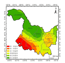
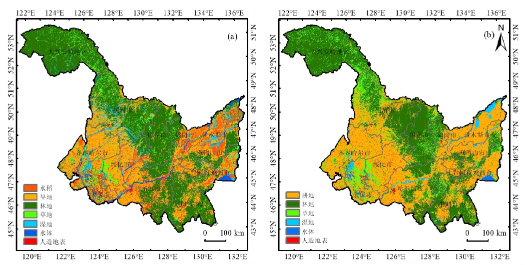
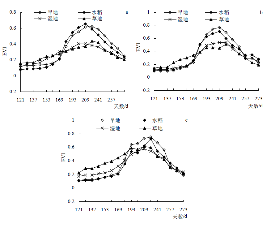
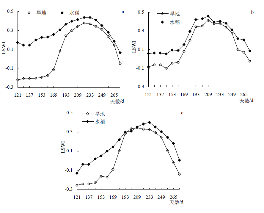
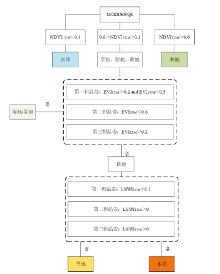
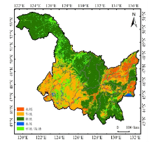
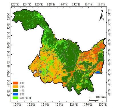
针对农业信息服务中大范围水田、旱田种植面积信息调查业务的现状与需求,以黑龙江省为研究区,通过分析水田、旱田作物发育期特征、MODIS数据植被指数(NDVI、EVI、LSWI)时序特征,引入积温条件分区构建决策规则,提取检测农田与其他、水田与旱田作物种植的空间分布。以实地调查地面验证点对分类结果进行验证,结果表明,分类结果达到了较高的识别精度,分类结果的总体精度为90.68%,Kappa系数为0.81,其中水稻制图精度为81.13%,用户精度为97.73%;旱地制图精度为98.46%,用户精度为87.07%;与不考虑积温条件相比,分类结果总体精度提高了12.77%,水稻制图精度提高了22.57%,旱地制图精度提高了5.94%。本研究通过引入积温条件,提高了大范围水稻、旱地作物提取精度,具有自动化程度高、分类结果稳定的特点。
中图分类号:
姜蓝齐, 王萍, 姜丽霞, 宫丽娟, 于成龙, 李秀芬. 基于多时相MODIS数据监测水、旱作物种植面积及空间分布[J]. 中国农学通报, 2021, 37(16): 108-118.
Jiang Lanqi, Wang Ping, Jiang Lixia, Gong Lijuan, Yu Chenglong, Li Xiufen. Estimation of Crop Planting Area and Spatial Distribution Based on MODIS NDVI Time-series Data of Rice and Dry Farmland Crops[J]. Chinese Agricultural Science Bulletin, 2021, 37(16): 108-118.


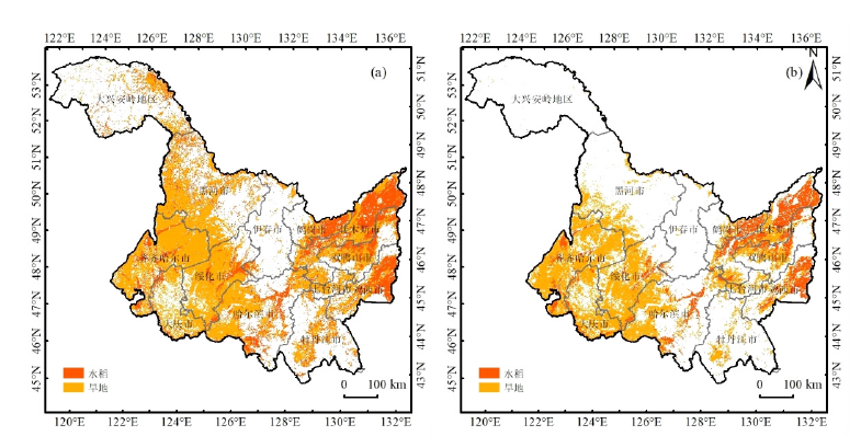
| 所辖地 | 黑龙江省统计年鉴 | 土地利用 | 本研究提取结果 | |||||
|---|---|---|---|---|---|---|---|---|
| 水稻面积 | 旱地面积 | 水稻面积 | 旱地面积 | 水稻面积 | 旱地面积 | |||
| 哈尔滨 | 5422.09 | 13735.86 | 5642.44 | 18209.57 | 5058.55 | 16588.07 | ||
| 齐齐哈尔 | 3531.32 | 18884.95 | 3400.46 | 27257.59 | 3286.36 | 27330.52 | ||
| 鸡西 | 1717.18 | 2604.82 | 2963.30 | 7785.82 | 2660.75 | 3393.75 | ||
| 鹤岗 | 998.54 | 884.30 | 2934.16 | 3687.32 | 3040.25 | 2331.2 | ||
| 双鸭山 | 867.43 | 3153.78 | 4027.74 | 7655.24 | 3517.85 | 4975.33 | ||
| 大庆 | 1106.11 | 6086.49 | 646.70 | 8467.43 | 1328.97 | 12408.91 | ||
| 伊春 | 391.84 | 1763.91 | 474.919 | 2366.15 | 316.12 | 1897.796 | ||
| 佳木斯 | 5192.3 | 6900.64 | 8014.39 | 11180.44 | 7698.75 | 8858.33 | ||
| 七台河 | 196.16 | 891.38 | 190.21 | 2782.64 | 218.33 | 1998.49 | ||
| 牡丹江 | 401.53 | 6146.9 | 942.90 | 8569.90 | 963.77 | 6444.14 | ||
| 黑河 | 140.51 | 10980.93 | 2.17 | 16417.09 | 80.90 | 10602.97 | ||
| 绥化 | 3480.43 | 15006.74 | 2791.81 | 18777.33 | 3212.25 | 17891.51 | ||
| 大兴安岭 | 0.04 | 1550.53 | 3.00 | 789.27 | 56.85 | 731.37 | ||
| 农垦总局 | 1527.4 | 27023.67 | — | — | — | — | ||
| 总计 | 24972.88 | 115614.90 | 32034.19 | 133945.79 | 31439.70 | 115452.39 | ||


| [1] | 陈仲新, 任建强, 唐华俊, 等. 农业遥感研究应用进展与展望[J]. 遥感学报, 2016,20(5):748-767. |
| [2] |
Vaudour E, Noirot-Cosson P E, Membrive O. Early-season mapping of crops and cultural operations using very high spatial resolution Pléiades images[J]. International Journal of Applied Earth Observation and Geoinformation, 2015,42:128-141.
doi: 10.1016/j.jag.2015.06.003 URL |
| [3] |
Atzberger C. Advances in remote sensing of agriculture: context description, existing operational monitoring systems and major information needs[J]. Remote Sensing, 2013,5(2):949-981.
doi: 10.3390/rs5020949 URL |
| [4] | 胡琼, 吴文斌, 宋茜, 等. 农作物种植结构遥感提取研究进展[J]. 中国农业科学, 2015,48(10):1900-1914. |
| [5] | 李明, 甄善继, 高祺, 等. 黑龙江省作物种植结构演变特点与调整对策研究[J]. 中国农业资源与区划, 2018,39(5):46-53. |
| [6] | 石延英, 郭尔静, 张镇涛, 等. 东北三省水稻生长季农业气候资源及障碍型冷害的时空特征[J]. 应用生态学报, 2020,31(5):203-213. |
| [7] |
Mariotto I, Thenkabail P S, Huete A, et al. Hyperspectral versus multispectral crop-productivity modeling and type discrimination for the HyspIRI mission[J]. Remote Sensing of Environment, 2013,139:291-305.
doi: 10.1016/j.rse.2013.08.002 URL |
| [8] |
Turker M, Ozdarici A. Field-based crop classification using SPOT4, SPOT5, IKONOS and QuickBird imagery for agricultural areas: a comparison study[J]. International Journal of Remote Sensing, 2011,32(24):9735-9768.
doi: 10.1080/01431161.2011.576710 URL |
| [9] |
Debats S R, Luo D, Estes L D, et al. A generalized computer vision approach to mapping crop fields in heterogeneous agricultural landscapes[J]. Remote Sensing of Environment, 2016,179:210-221.
doi: 10.1016/j.rse.2016.03.010 URL |
| [10] |
Durgun Y, Gobin A, Ruben V D K, et al. Crop area mapping using 100-m proba-V time series[J]. Remote Sensing, 2016,8(7):585.
doi: 10.3390/rs8070585 URL |
| [11] |
Mulianga B, Bégué A, Clouvel P, et al. Mapping cropping practices of a sugarcane based cropping system in kenya using remote sensing[J]. Remote Sensing, 2011,7(11):14428-14444.
doi: 10.3390/rs71114428 URL |
| [12] |
Siachalou S, Mallinis G, Tsakiristrati M. A hidden markov models approach for crop classification: linking crop phenology to time series of multi-sensor remote sensing data[J]. Remote Sensing, 2015,7(4):3633-3650.
doi: 10.3390/rs70403633 URL |
| [13] | 朱爽, 张锦水. 农作物遥感变化检测识别研究进展[J]. 中国农业资源与区划, 2015,36(7):159-168. |
| [14] | 姚成, 赵晋陵. 基于时序HJ-CCD影像的区域尺度水稻提取方法研究[J]. 南京农业大学学报, 2015,38(6):1023-1029. |
| [15] | 杨闫君, 占玉林, 田庆久, 等. 基于GF-1/WFV NDVI时间序列数据的作物分类[J]. 农业工程学报, 2015,(24):155-161. |
| [16] | 王利民, 刘佳, 杨玲波, 等. 基于NDVI加权指数的冬小麦种植面积遥感监测[J]. 农业工程学报, 2016,32(17):127-135. |
| [17] | 谢登峰, 张锦水, 潘耀忠, 等. Landsat 8和MODIS融合构建高时空分辨率数据识别秋粮作物[J]. 遥感学报, 2015,19(5):791-805. |
| [18] |
Lobell D B, Asner G P. Cropland distributions from temporal unmixing of MODIS data[J]. Remote Sensing of Environment, 2004,93(3):412-422.
doi: 10.1016/j.rse.2004.08.002 URL |
| [19] | 林文鹏, 王长耀, 黄敬峰, 等. 基于MODIS数据和模糊ARTMAP的冬小麦遥感识别方法[J]. 农业工程学报, 2008,24(3):173-178. |
| [20] | 熊勤学, 黄敬峰. 利用NDVI指数时序特征监测秋收作物种植面积[J]. 农业工程学报, 2009,25(1):144-148. |
| [21] | 闫峰, 王艳姣, 武建军, 等. 基于Ts-EVI时间序列谱的冬小麦面积种植[J]. 农业工程学报, 2009,25(4):135-140. |
| [22] | 刘珺, 田庆久. 夏玉米最佳时序谱段组合识别模式研究[J]. 遥感信息, 2015(2):105-110. |
| [23] | 平跃鹏, 臧淑英. 基于MODIS时间序列及物候特征的农作物分类[J]. 自然资源学报, 2016,31(3):503-513. |
| [24] |
Xiao X, Boles S, Frolking S, et al. Mapping paddy rice agriculture in South and Southeast Asia using multi-temporal MODIS images[J]. Remote Sensing of Environment, 2006,100(1):95-113.
doi: 10.1016/j.rse.2005.10.004 URL |
| [25] |
Xiao X, Boles S, Liu J, et al. Mapping paddy rice agriculture in southern China using multi-temporal MODIS images[J]. Remote Sensing of Environment, 2005,95(4):480-492.
doi: 10.1016/j.rse.2004.12.009 URL |
| [26] | Zhang G, Xiao X, Dong J, et al. Mapping paddy rice planting areas through time series analysis of MODIS land surface temperature and vegetation index data[J]. ISPRS Journal of Photogrammetry & Remote Sensing, 2015,106:157-171. |
| [27] |
Wardlow B D, Egbert S L. Large-area crop mapping using time-series MODIS 250m NDVI data: An assessment for the U.S. Central Great Plains[J]. Remote Sensing of Environment, 2008,112(3):1096-1116.
doi: 10.1016/j.rse.2007.07.019 URL |
| [28] | Zhong L, Hu L, Yu L, et al. Automated mapping of soybean and corn using phenology[J]. ISPRS Journal of Photogrammetry & Remote Sensing, 2016,119:151-164. |
| [29] | Wang C, Fan Q, Li Q, et al. Energy crop mapping with enhanced TM/MODIS time series in the BCAP agricultural lands[J]. ISPRS Journal of Photogrammetry & Remote Sensing, 2017,124:133-143. |
| [30] | 黑龙江省统计局, 国家统计局黑龙江分队. 黑龙江统计年鉴[M]. 北京: 中国统计出版社, 2018. |
| [1] | 白玛仁增, 顿玉多吉, 德例归吉, 德吉央宗, 益西多吉, 边巴次仁. 星-地结合对水稻高温热害监测模型的研究[J]. 中国农学通报, 2023, 39(1): 133-141. |
| [2] | 罗先富, 刘文强, 潘孝武, 董铮, 刘三雄, 刘利成, 阳标仁, 盛新年, 李小湘. 应用剩余杂合体衍生的近等基因系定位水稻株高QTL[J]. 中国农学通报, 2022, 38(9): 1-5. |
| [3] | 黄钰, 陈斌, 肖关丽. 云南哈尼族地方水稻‘月亮谷’对褐飞虱取食危害的生理反应[J]. 中国农学通报, 2022, 38(9): 123-129. |
| [4] | 李兴华, 王欢, 张盛, 蔡星星, 周强, 周楠. 氮肥用量与运筹方式对晚籼稻产量及花后干物质积累与转运的影响[J]. 中国农学通报, 2022, 38(9): 6-13. |
| [5] | 王一凡, 劳晓璨, 余丽萍, 叶海龙. 水稻‘甬优15’分期播种的气象条件适宜性试验研究[J]. 中国农学通报, 2022, 38(7): 106-109. |
| [6] | 李雪枫, 王坚, 叶晓园, 张秀婷, 王丽学. 苦瓜植株水浸提液对水稻种子萌发和秧苗生长的影响[J]. 中国农学通报, 2022, 38(6): 1-7. |
| [7] | 闫蕴韬, 何兮, 张海清, 贺记外. 水稻种子耐贮性研究进展[J]. 中国农学通报, 2022, 38(5): 1-8. |
| [8] | 翟彩娇, 张蛟, 崔士友, 陈澎军. 盐逆境对耐盐水稻穗部性状及产量构成因素的影响[J]. 中国农学通报, 2022, 38(4): 1-9. |
| [9] | 李荣田, 时柳, 黄丽莹, 刘长华. 利用分子选择培育水稻‘吉粳88’(hd2/hd4)导入系[J]. 中国农学通报, 2022, 38(33): 1-9. |
| [10] | 伊嘉雯, 冯棣, 朱崴, 亓娜, 滕奉魁, 卢小引. 不同品种水稻发芽阶段耐盐性对比研究[J]. 中国农学通报, 2022, 38(33): 10-14. |
| [11] | 张博, 石峰, 宋福强. AMF复合菌剂对寒地水稻光合作用和生长效应的影响[J]. 中国农学通报, 2022, 38(33): 15-22. |
| [12] | 胡馨月, 孙倩, 古丽古丽·灭迪力哈孜. 新疆布尔津县五年间归一化植被指数时空演变[J]. 中国农学通报, 2022, 38(32): 6-11. |
| [13] | 许丹阳, 李虹颖, 孙义祥, 邬刚, 王家宝, 袁嫚嫚, 王佩旋, 张祥明, 束孝海. 不同比例有机无机肥配施对水稻产量与氮素利用率的影响[J]. 中国农学通报, 2022, 38(31): 1-5. |
| [14] | 王洋, 张瑞, 周雨晴, 刘永昊, 刘高生, 戴其根. 基于文献计量的国内水稻耐盐性研究态势分析[J]. 中国农学通报, 2022, 38(31): 147-153. |
| [15] | 李舟, 杨雅云, 戴陆园, 张斐斐, 阿新祥, 董超, 王斌, 汤翠凤. 水稻白叶枯病抗性基因和相关因子研究利用进展[J]. 中国农学通报, 2022, 38(30): 91-99. |
| 阅读次数 | ||||||
|
全文 |
|
|||||
|
摘要 |
|
|||||