欢迎访问《中国农学通报》,
中国农学通报 ›› 2020, Vol. 36 ›› Issue (31): 77-85.doi: 10.11924/j.issn.1000-6850.casb20190900690
吴铭婉( ), 臧传富(), 傅家仪
收稿日期:2019-09-27
修回日期:2020-04-13
出版日期:2020-11-05
发布日期:2020-11-20
通讯作者:
臧传富
作者简介:吴铭婉,女,1998年出生,广东汕头人,本科,主要从事地理信息科学研究。通信地址:510631 广东广州中山大道西55号 华南师范大学地理科学学院,Tel:020-85211380,E-mail:基金资助:
Wu Mingwan(), Zang Chuanfu(), Fu Jiayi
Received:2019-09-27
Revised:2020-04-13
Online:2020-11-05
Published:2020-11-20
Contact:
Zang Chuanfu
摘要:
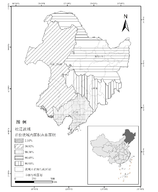
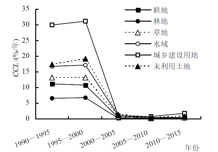
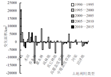
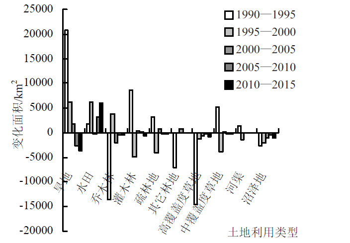
为探索整个松辽流域片区1990—2015年的土地利用时空变化特征及驱动机制,通过ArcGIS空间分析、土地利用转移矩阵、SPSS相关分析和因子分析等方法,分析社会经济统计数据和气候数据。结果表明,松辽流域1990—2015年的土地利用变化差异显著。土地类型占地面积为林地>耕地>草地>未利用土地>水域>城乡建设用地,土地变化面积为耕地>草地>林地>未利用土地>水域>城乡建设用地。1990—2000年耕地、林地、草地和未利用土地相互转化明显,建设用地迅速扩张。乔木林、高覆盖草地分别减少了1.26万、1.74万km2,旱地增加了2.25万km2。松辽流域片区的土地利用变化主要驱动因子是经济发展和人口增长。本研究从流域片区尺度上为松辽流域片区的土地资源管理和规划提供理论参考。
中图分类号:
吴铭婉, 臧传富, 傅家仪. 松辽流域片区1990—2015年土地利用变化及驱动机制研究[J]. 中国农学通报, 2020, 36(31): 77-85.
Wu Mingwan, Zang Chuanfu, Fu Jiayi. Spatial and Temporal Variability Characteristics and Driving Mechanism of Land-use in Songliao River Basin from 1990 to 2015[J]. Chinese Agricultural Science Bulletin, 2020, 36(31): 77-85.

| 因素 | 因子 | 指标符号 | 指标名称 | 单位 |
|---|---|---|---|---|
| 人类活动 | 人口数量 及结构 | X1 | 人口数量 | 万人 |
| X2 | 人口密度 | 人/km2 | ||
| 经济发展 | X3 | 全社会固定资产投资总额 | 亿元 | |
| X4 | GDP | 亿元 | ||
| X5 | 人均GDP | 元/人 | ||
| X6 | 工业总产值 | 亿元 | ||
| X7 | 农业总产值 | 亿元 | ||
| X8 | 林业总产值 | 亿元 | ||
| X9 | 牧业总产值 | 亿元 | ||
| X10 | 全社会消费品零售总额 | 亿元 | ||
| 政治 | X11 | 财政收入 | 亿元 | |
| X12 | 财政支出 | 亿元 | ||
| 自然环境 | 气候 | X13 | 降水量 | mm |
| X14 | 气温 | ℃ |
| 年份 | 耕地 | 林地 | 草地 | 水域 | 城乡建设用地 | 未利用土地 | |||||||||||
|---|---|---|---|---|---|---|---|---|---|---|---|---|---|---|---|---|---|
| 面积/ km2 | 占比/ % | 面积/ km2 | 占比/ % | 面积/ km2 | 占比/ % | 面积/ km2 | 占比/ % | 面积/ km2 | 占比/ % | 面积/ km2 | 占比/ % | ||||||
| 1990 | 339250 | 27.44 | 521689 | 42.20 | 246879 | 19.97 | 30683 | 2.48 | 24412 | 1.97 | 73316 | 5.93 | |||||
| 1995 | 362064 | 29.29 | 512267 | 41.44 | 238041 | 19.25 | 30220 | 2.44 | 25463 | 2.06 | 68238 | 5.52 | |||||
| 2000 | 374931 | 30.32 | 507136 | 41.02 | 231988 | 18.76 | 29208 | 2.36 | 24754 | 2.00 | 68371 | 5.53 | |||||
| 2005 | 376744 | 30.47 | 506990 | 41.01 | 231418 | 18.72 | 28597 | 2.31 | 25159 | 2.03 | 67496 | 5.46 | |||||
| 2010 | 377197 | 30.51 | 506487 | 40.96 | 231099 | 18.69 | 28851 | 2.33 | 25545 | 2.07 | 67228 | 5.44 | |||||
| 2015 | 380154 | 30.75 | 505147 | 40.86 | 229787 | 18.59 | 28741 | 2.32 | 26813 | 2.17 | 65762 | 5.32 | |||||
| 1995年 | ||||||||||
|---|---|---|---|---|---|---|---|---|---|---|
| 耕地 | 林地 | 草地 | 水域 | 城镇用地 | 农村居民点 | 其他建设用地 | 未利用土地 | 减少量 | ||
| 1990年 | 耕地 | 254919 | 34391 | 23938 | 4171 | 934 | 12140 | 308 | 8247 | 84129 |
| 林地 | 42389 | 431301 | 36892 | 2252 | 204 | 1781 | 136 | 6372 | 90026 | |
| 草地 | 33384 | 35740 | 161270 | 2321 | 128 | 1556 | 66 | 12285 | 85480 | |
| 水域 | 5476 | 2885 | 2187 | 17304 | 56 | 345 | 228 | 1895 | 13073 | |
| 城镇用地 | 850 | 183 | 104 | 46 | 2685 | 164 | 30 | 34 | 1411 | |
| 农村居民点 | 12093 | 1591 | 1341 | 326 | 32 | 3171 | 32 | 541 | 15956 | |
| 其他建设用地 | 251 | 100 | 42 | 10 | 14 | 34 | 691 | 12 | 462 | |
| 未利用土地 | 12519 | 5710 | 12027 | 3591 | 31 | 591 | 49 | 38751 | 34519 | |
| 增加量 | 106963 | 80600 | 76530 | 12717 | 1400 | 16611 | 848 | 29388 | —— | |
| 2000年 | ||||||||||
|---|---|---|---|---|---|---|---|---|---|---|
| 耕地 | 林地 | 草地 | 水域 | 城镇用地 | 农村居民点 | 其他建设用地 | 未利用土地 | 减少量 | ||
| 1995年 | 耕地 | 269850 | 38692 | 24066 | 4965 | 1061 | 12756 | 298 | 10169 | 92007 |
| 林地 | 43539 | 421479 | 35892 | 2858 | 252 | 1822 | 106 | 5896 | 90364 | |
| 草地 | 29867 | 35600 | 156134 | 2078 | 135 | 1675 | 53 | 12278 | 81686 | |
| 水域 | 4756 | 2436 | 2344 | 16406 | 82 | 326 | 19 | 3656 | 13617 | |
| 城镇用地 | 886 | 187 | 112 | 87 | 2710 | 51 | 18 | 33 | 1373 | |
| 农村居民点 | 13403 | 1794 | 1436 | 401 | 206 | 1762 | 41 | 733 | 18014 | |
| 其他建设用地 | 310 | 119 | 56 | 207 | 38 | 46 | 708 | 47 | 824 | |
| 未利用土地 | 12113 | 6405 | 11786 | 1829 | 36 | 497 | 19 | 35502 | 32684 | |
| 增加量 | 104874 | 85233 | 75692 | 12426 | 1808 | 17172 | 552 | 32812 | —— | |
| 2005年 | ||||||||||
|---|---|---|---|---|---|---|---|---|---|---|
| 耕地 | 林地 | 草地 | 水域 | 城镇用地 | 农村居民点 | 其他建设用地 | 未利用土地 | 减少量 | ||
| 2000年 | 耕地 | 371680 | 924 | 1246 | 152 | 148 | 332 | 107 | 340 | 3248 |
| 林地 | 1276 | 504072 | 1456 | 38 | 18 | 19 | 22 | 228 | 3056 | |
| 草地 | 1798 | 1787 | 227436 | 72 | 5 | 24 | 28 | 832 | 4546 | |
| 水域 | 390 | 30 | 112 | 28142 | 5 | 3 | 3 | 520 | 1063 | |
| 城镇用地 | 31 | 1 | 2 | 0 | 4483 | 5 | 6 | 1 | 45 | |
| 农村居民点 | 258 | 9 | 16 | 0 | 22 | 18642 | 5 | 5 | 316 | |
| 其他建设用地 | 1 | 1 | 0 | 2 | 3 | 0 | 1260 | 0 | 7 | |
| 未利用土地 | 1305 | 157 | 1147 | 181 | 6 | 7 | 1 | 65566 | 2803 | |
| 增加量 | 5059 | 2909 | 3978 | 444 | 207 | 389 | 173 | 1925 | —— | |
| 2010年 | ||||||||||
|---|---|---|---|---|---|---|---|---|---|---|
| 耕地 | 林地 | 草地 | 水域 | 城镇用地 | 农村居民点 | 其他建设用地 | 未利用土地 | 减少量 | ||
| 2005年 | 耕地 | 374759 | 729 | 358 | 203 | 262 | 164 | 69 | 199 | 1983 |
| 林地 | 992 | 505526 | 312 | 55 | 24 | 7 | 23 | 50 | 1463 | |
| 草地 | 597 | 188 | 230350 | 76 | 17 | 5 | 10 | 175 | 1067 | |
| 水域 | 77 | 3 | 1 | 28490 | 6 | 0 | 2 | 18 | 106 | |
| 城镇用地 | 26 | 2 | 1 | 0 | 4659 | 0 | 2 | 0 | 31 | |
| 农村居民点 | 166 | 4 | 4 | 11 | 51 | 18784 | 7 | 3 | 247 | |
| 其他建设用地 | 4 | 0 | 0 | 0 | 7 | 0 | 1426 | 0 | 11 | |
| 未利用土地 | 573 | 32 | 73 | 15 | 8 | 1 | 7 | 66785 | 710 | |
| 增加量 | 2436 | 958 | 748 | 361 | 375 | 177 | 120 | 443 | —— | |
| 2015年 | ||||||||||
|---|---|---|---|---|---|---|---|---|---|---|
| 耕地 | 林地 | 草地 | 水域 | 城镇用地 | 农村居民点 | 其他建设用地 | 未利用土地 | 减少量 | ||
| 2010年 | 耕地 | 373960 | 1134 | 511 | 126 | 496 | 298 | 391 | 273 | 3229 |
| 林地 | 2388 | 503605 | 277 | 16 | 25 | 21 | 83 | 70 | 2879 | |
| 草地 | 1732 | 299 | 228651 | 28 | 33 | 49 | 142 | 163 | 2447 | |
| 水域 | 264 | 11 | 25 | 28484 | 7 | 3 | 13 | 41 | 364 | |
| 城镇用地 | 55 | 4 | 1 | 0 | 4952 | 3 | 20 | 1 | 85 | |
| 农村居民点 | 304 | 7 | 12 | 2 | 40 | 18576 | 21 | 0 | 385 | |
| 其他建设用地 | 19 | 5 | 2 | 0 | 9 | 2 | 1507 | 0 | 37 | |
| 未利用土地 | 1428 | 79 | 306 | 83 | 33 | 16 | 70 | 65211 | 2015 | |
| 增加量 | 6190 | 1539 | 1134 | 254 | 643 | 391 | 741 | 549 | —— | |


| 土地类型 | 主成分 | 特征值 | 贡献率/% | 累计贡献率/% |
|---|---|---|---|---|
| 旱地 | 1 | 11.326 | 80.900 | 80.900 |
| 2 | 1.733 | 12.382 | 93.282 | |
| 乔木林 | 1 | 6.686 | 74.286 | 74.286 |
| 2 | 1.575 | 17.502 | 91.789 | |
| 高覆盖草地 | 1 | 9.327 | 84.787 | 84.787 |
| 2 | 1.057 | 9.609 | 94.396 | |
| 滩涂 | 1 | 4.891 | 69.868 | 69.868 |
| 2 | 1.353 | 19.323 | 89.192 | |
| 其他建设用地 | 1 | 11.326 | 80.900 | 80.900 |
| 2 | 1.733 | 12.382 | 93.282 |
| 主成分 | 旱地 | 乔木林 | 高覆盖草地 | 滩涂 | 其他建设用地 | |||||||||
|---|---|---|---|---|---|---|---|---|---|---|---|---|---|---|
| 1 | 2 | 1 | 2 | 1 | 2 | 1 | 2 | 1 | 2 | |||||
| X1 | 0.807 | -0.552 | 0.866 | -0.472 | 0.808 | -0.531 | 0.925 | -0.340 | 0.807 | -0.552 | ||||
| X2 | 0.807 | -0.552 | 0.866 | -0.472 | 0.808 | -0.532 | 0.925 | -0.340 | 0.807 | -0.552 | ||||
| X3 | 0.979 | 0.116 | — | — | 0.972 | 0.185 | 0.901 | 0.317 | 0.979 | 0.116 | ||||
| X4 | 0.991 | 0.132 | 0.968 | 0.215 | 0.990 | 0.140 | — | — | 0.991 | 0.132 | ||||
| X5 | 0.990 | 0.140 | 0.967 | 0.223 | 0.990 | 0.143 | — | — | 0.990 | 0.140 | ||||
| X6 | 0.965 | -0.082 | — | — | 0.954 | 0.051 | — | — | 0.965 | -0.082 | ||||
| X7 | 0.970 | 0.229 | 0.949 | 0.315 | 0.974 | 0.168 | 0.891 | 0.449 | 0.970 | 0.229 | ||||
| X8 | 0.971 | 0.215 | 0.948 | 0.299 | 0.974 | 0.192 | — | — | 0.971 | 0.215 | ||||
| X9 | 0.987 | 0.151 | 0.966 | 0.236 | 0.988 | 0.144 | 0.917 | 0.367 | 0.987 | 0.151 | ||||
| X10 | 0.966 | 0.247 | — | — | 0.970 | 0.200 | — | — | 0.966 | 0.247 | ||||
| X11 | 0.979 | -0.001 | — | — | — | — | — | — | 0.979 | -0.001 | ||||
| X12 | 0.979 | 0.192 | — | — | — | — | — | — | 0.979 | 0.192 | ||||
| X13 | -0.605 | 0.232 | -0.673 | 0.154 | -0.626 | 0.538 | -0.709 | -0.005 | -0.605 | 0.232 | ||||
| X14 | -0.312 | 0.891 | -0.359 | 0.875 | — | — | -0.481 | 0.827 | -0.312 | 0.891 | ||||
| [1] | 徐小明, 戴子扬, 闫瑾, 等. 基于RDA的县域土地利用/覆被变化驱动力研究[J]. 山西大学学报:自然科学版, 2017(4):226-232. |
| [2] | 张冠华, 张平仓, 张晓峰. 三峡库区土地利用/覆被变化及其驱动力研究进展[J]. 中国水土保持, 2017,(5):47-51. |
| [3] | Wei B, Xie Y, Jia X, et al. Land use/land cover change and it's impacts on diurnal temperature range over the agricultural pastoral ecotone of Northern China[J]. Land degradation & development, 2018,29(9):3009-3020. |
| [4] | Zhao De-Ming, Wu Jian. Evaluating the impacts of land use and land cover changes on surface air temperature using the WRF-mosaic approach[J]. Atmospheric and Oceanic Science Letters, 2018,(3):262-269. |
| [5] |
Sewnet A, Abebe G . Land use and land cover change and implication to watershed degradation by using GIS and remote sensing in the Koga watershed, North Western Ethiopia[J]. Earth Science Informatics, 2018,11(1):99-108.
doi: 10.1007/s12145-017-0323-5 URL |
| [6] | 韩云环, 郑子彦, 肖宇, 等. 基于统计年鉴和MODIS的中国区域土地利用/覆盖变化特征研究[J]. 气候与环境研究, 2017,22(6):733-746. |
| [7] | 黄志基, 贺灿飞, 王伟凯. 土地利用变化与中国城市经济增长研究[J]. 城市发展研究, 2013,20(7):35-43. |
| [8] | 宋乃平, 张凤荣, 杨洋. 国内土地利用/覆被变化研究的回顾与展望[A]. 中国西部科技进步与经济社会发展专家论坛[C]. 2009. |
| [9] | 刘纪远, 匡文慧, 张增祥, 等. 20世纪80年代以来中国土地利用变化的基本特征与空间格局[J]. 地理学报:英文版, 2014,24(2):195-210. |
| [10] |
Quintero-Gallego M E, Quintero-Angel M, Vila-Ortega J J. Exploring land use/ land cover change and drivers in Andean mountains in Colombia: A case in rural Quindío[J]. Science of The Total Environment, 2018,634:1288-1299.
doi: 10.1016/j.scitotenv.2018.03.359 URL |
| [11] |
Yang Y, Liu Y, Xu D, et al. Use of intensity analysis to measure land use changes from 1932 to 2005 in Zhenlai County, Northeast China[J]. Chinese Geographical Science, 2017,27(3):441-455.
doi: 10.1007/s11769-017-0876-8 URL |
| [12] | Maimaiti A, Wang L M, Yan F, et al. Quantitative analysis of land use and land cover changes from the multi-temporal remote sensing data in the Bosten Lake Basin, Chinese Tian Shan[A]. //IOP Conference Series: Earth and Environmental Science[C]. IOP Publishing, 2017: 12011. |
| [13] |
Wang R, Kalin L, Kuang W, et al. Individual and combined effects of land use/cover and climate change on Wolf Bay watershed streamflow in southern Alabama[J]. Hydrological Processes, 2014,28(22):5530-5546.
doi: 10.1002/hyp.10057 URL |
| [14] |
Yang L, Feng Q, Yin Z, et al. Identifying separate impacts of climate and land use/cover change on hydrological processes in upper stream of Heihe River, Northwest China[J]. Hydrological Processes, 2017,31(5):1100-1112.
doi: 10.1002/hyp.v31.5 URL |
| [15] |
Li J, Wang Z, Lai C, et al. Response of net primary production to land use and land cover change in mainland China since the late 1980s[J]. Science of the Total Environment, 2018,639:237-247.
doi: 10.1016/j.scitotenv.2018.05.155 URL |
| [16] |
高歌, 许崇育. 1961—2010年中国十大流域水分盈亏量时空变化特征[J]. 地理学报, 2015,70(3):380-391.
doi: 10.11821/dlxb201503003 URL |
| [17] | 方国华, 戚核帅, 闻昕, 等. 气候变化条件下21世纪中国九大流域极端月降水量时空演变分析[J]. 自然灾害学报, 2016,25(02):015-25. |
| [18] | 袁磊, 杨昆, 赵俊三. 云南省土地利用变化特征及耕地变化驱动因素分析[J]. 国土资源科技管理, 2015,32(3):1-10. |
| [19] | 白含之, 姜琦刚. 近20年来长春市土地利用变化及其影响因素探讨[J]. 江西农业学报, 2017(9). |
| [20] | 高凤杰, 马泉来, 单培明, 等. 黑龙江省穆棱市土地利用/覆被变化及热点分析[J]. 地域研究与开发, 2016,35(4):126-130. |
| [21] | 何俊仕, 王志新, 付玉娟, 等. 西辽河平原土地利用/覆被变化特征分析[J]. 中国农村水利水电, 2016(11):66-69. |
| [22] | 吴迪, 张冬有. 1990—2015年东北三省土地利用/覆被时空变化特征及其驱动力分析[J]. 江苏农业科学, 2018(8):68. |
| [23] | 王秀娟, 刘瑞民, 何孟常. 土地利用及其变化对松辽流域非点源污染影响研究[J]. 地理科学, 2009,29(4):555-560. |
| [24] |
杜国明, 孙晓兵, 王介勇. 东北地区土地利用多功能性演化的时空格局[J]. 地理科学进展, 2016,35(2):232-244.
doi: 10.18306/dlkxjz.2016.02.010 URL |
| [25] | 辽宁省统计局, 国家统计局辽宁调查总队. 辽宁统计年鉴[M]. 北京: 中国统计出版社, 1991-2016. |
| [26] | 吉林省统计局, 国家统计局吉林调查总队. 吉林统计年鉴[M]. 北京: 中国统计出版社, 1991-2016. |
| [27] | 黑龙江省统计局, 国家统计局黑龙江调查总队. 黑龙江统计年鉴[M]. 北京: 中国统计出版社, 1991-2016. |
| [28] | 内蒙古自治区统计局. 内蒙古统计年鉴[M]. 北京: 中国统计出版社, 1991-2016. |
| [29] | 国家统计局城市社会经济调查司. 中国城市统计年鉴[M]. 北京: 中国统计出版社, 1991-2016. |
| [30] |
陈百明, 周小萍. 《土地利用现状分类》国家标准的解读[J]. 自然资源学报, 2007,22(6):994-1003.
doi: 10.11849/zrzyxb.2007.06.017 URL |
| [31] |
Fan Y, Yu G, He Z, et al. Entropies of the Chinese land use/cover change from 1990 to 2010 at a county level[J]. Entropy, 2017,19(2):51.
doi: 10.3390/e19020051 URL |
| [32] |
刘盛和, 何书金. 土地利用动态变化的空间分析测算模型[J]. 自然资源学报, 2002,17(5):533-540.
doi: 10.11849/zrzyxb.2002.05.002 URL |
| [33] | 吴滢滢, 吴绍华, 周生路, 等. 昆山市土地生态质量空间分异及其对土地利用程度的响应[J]. 水土保持研究, 2015(4):201-205. |
| [34] |
Li Z, Ren Y, Li J, et al. Land-Use/Cover Change and Driving Mechanism on the West Bank of Lake Baikal from 2005 to 2015- A Case Study of Irkutsk City[J]. Sustainability, 2018,10(8):2904.
doi: 10.3390/su10082904 URL |
| [1] | 刘翠兰, 王开芳, 吴德军, 燕丽萍, 李善文, 王芳, 任飞, 王因花. 滨海盐碱胁迫下白蜡无性系生长及生理特性的响应[J]. 中国农学通报, 2022, 38(35): 7-16. |
| [2] | 韩伟, 徐珊. 松嫩平原土地利用变化特征及生态系统服务价值研究——以哈尔滨市为例[J]. 中国农学通报, 2022, 38(26): 82-90. |
| [3] | 马苏, 崔国屹, 赵玉, 赵莹, 刘雪珍, 张承栋. 植被NPP时空变化特征及驱动因子分析——以延安地区为例[J]. 中国农学通报, 2022, 38(19): 93-98. |
| [4] | 单建军, 管崇武, 宋红桥, 刘世晶, 洪扬, 庄保陆. 基于主成分分析的吸鱼泵对鱼类损伤评价方法[J]. 中国农学通报, 2021, 37(29): 140-145. |
| [5] | 韩丽萍, 郭卫卫, 韩晓凡, 李夕梅, 王会芳, 张玉梅, 仇宏伟. 利用SOM聚类分析及主成分分析方法鉴定小麦品种萌发期耐盐性[J]. 中国农学通报, 2021, 37(24): 6-17. |
| [6] | 李保莲,申圣洁,焦俊党,李华超. 村域土地生态状况动态评估[J]. 中国农学通报, 2019, 35(4): 62-68. |
| [7] | 王莎莎,张贵友. 基于主成分分析法的国家农业科技园区综合效益的实证研究[J]. 中国农学通报, 2018, 34(27): 159-164. |
| [8] | 春 兰,秦福莹,包玉海. 3个时期达里诺尔国家级湿地自然保护区土地利用动态研究[J]. 中国农学通报, 2018, 34(13): 100-105. |
| [9] | 张俊平,李净. 基于CA-Markov模型的甘州区土地利用变化预测分析[J]. 中国农学通报, 2017, 33(4): 105-110. |
| [10] | 孙栋元,金彦兆,柴薇薇,胡想全,卢书超,宋增芳,曾建军. 石羊河流域土地利用变化分形特征研究[J]. 中国农学通报, 2016, 32(35): 80-87. |
| [11] | 李富程,赵 丽,王 青,樊 敏,王海茳. 岷江上游聚落生态位内部土地利用变化特征[J]. 中国农学通报, 2016, 32(20): 85-91. |
| [12] | 张中旺,周萍. 基于主成分分析的襄阳市水资源短缺风险评价[J]. 中国农学通报, 2016, 32(2): 92-98. |
| [13] | 牛乐德. 昆明市耕地变化特征及驱动机制研究[J]. 中国农学通报, 2015, 31(7): 251-255. |
| [14] | 郭义强,陈朝峰,陈朝锋,韩 赜,刘 琳. 河北省柏乡县土地整理项目的碳排放效应研究[J]. 中国农学通报, 2015, 31(36): 205-210. |
| [15] | 艾晓艳,赵源,王大川. 基于碳效应的荥经县土地系统脆弱性分析[J]. 中国农学通报, 2015, 31(29): 113-122. |
| 阅读次数 | ||||||
|
全文 |
|
|||||
|
摘要 |
|
|||||