欢迎访问《中国农学通报》,

中国农学通报 ›› 2021, Vol. 37 ›› Issue (14): 106-115.doi: 10.11924/j.issn.1000-6850.casb2020-0461

所属专题: 农业气象

• 资源·环境·生态·土壤·气象 • 上一篇    下一篇

极端气候事件对1978—2017年广西农作物的灾损影响

王奥枫(), 陈世恒, 唐湘玲()   

  1. 桂林理工大学地球科学学院,广西桂林 541004
  • 收稿日期:2020-09-14 修回日期:2020-11-18 出版日期:2021-05-15 发布日期:2021-05-19
  • 通讯作者: 唐湘玲
  • 作者简介:王奥枫,男,1999年出生,湖北黄石人,本科,主要从事土地利用变化与农作物灾害研究。通信地址:435200 湖北省黄石市阳新县, E-mail: waafeng@foxmail.com
  • 基金资助:
    国家自然科学基金“岩溶灌区多尺度氮磷运移规律及其对变化环境的响应机制”(51979046);广西自然基金项目“未来气候变化背景下广西持续性暴雨事件对漓江流域洪水危险性的影响”(2018GXNSFAA050009);广西自然科学基金“西南岩溶灌区氮磷迁移转化对变化环境的响应机理”(2018GXNSFAA294087);国家级大学生创新创业项目“漓江流域潜在土地利用冲突动态演变研究”(202010596005)

The Effects of Extreme Weather Events on Crops in Guangxi from 1978 to 2017

Wang Aofeng(), Chen Shiheng, Tang Xiangling()   

  1. Earth Science College, Guilin University of Technology Institute, Guangxi 541004
  • Received:2020-09-14 Revised:2020-11-18 Online:2021-05-15 Published:2021-05-19
  • Contact: Tang Xiangling

摘要:

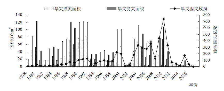
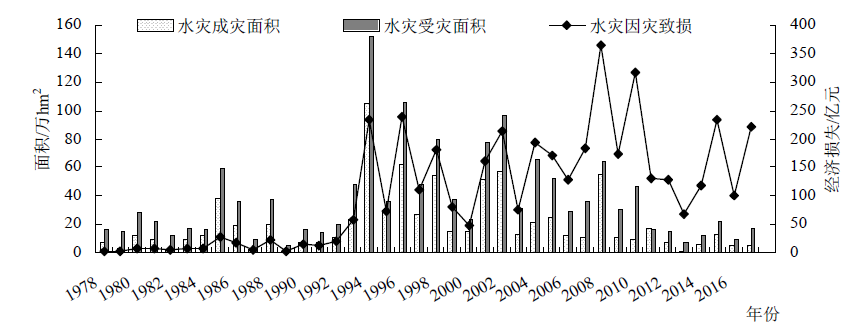
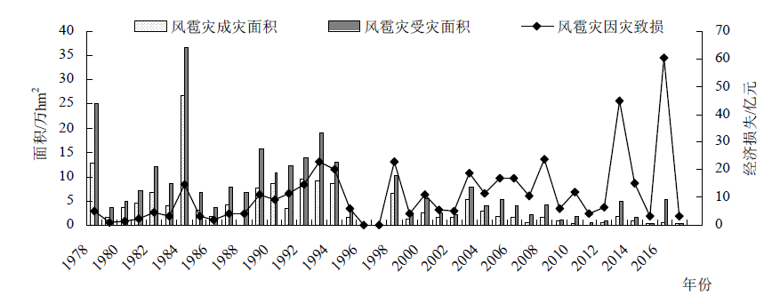
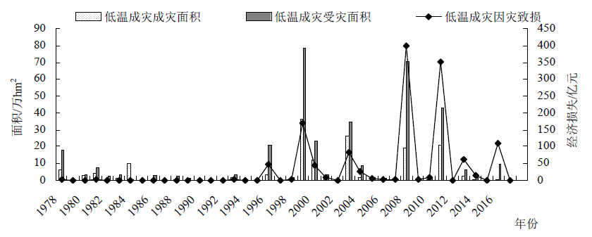
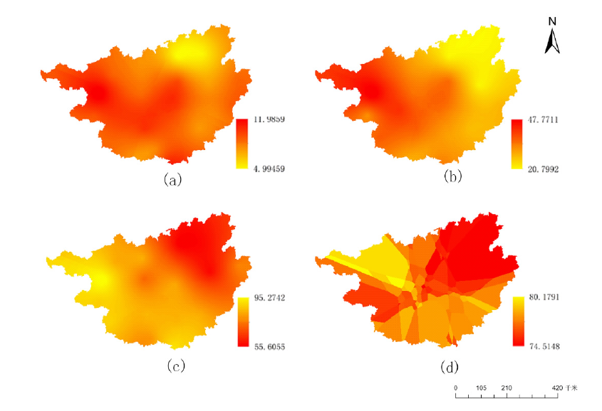
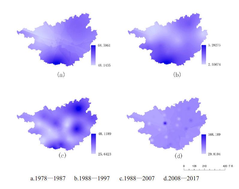
为了降低极端气候事件对农作物产量与经济的损失,本文基于灾害学理论,运用数理统计的趋势分析等方法,分析了1978—2017年旱灾、水灾、风雹灾与低温成灾4种极端气候事件对广西区农作物成灾、受灾面积的影响。并用极端气候事件的气候因素响应频率来近似代替一定区域极端气候发生的概率,结合1978—2017年4种极端气候事件灾损评估,对广西区旱灾、水灾、风雹灾与低温成灾进行时空分析,揭示其时空变化趋势。结果表明:(1)研究期内,广西区农作物因灾致损程度为:旱灾>水灾>低温成灾>风雹灾;(2)广西区由旱灾引起的农作物受灾面积与成灾面积呈下降趋势,因灾致损严重区域由中部与西部逐步变化至西南部与东北部;(3)广西区由水灾引起的农作物受灾面积与成灾面积变化呈上升趋势,因灾致损严重区域由南部向中西部逐渐变化;(4)广西区由风雹灾引起的农作物受灾面积与成灾面积变化呈下降趋势,因灾致损严重区域由北部与南部向中部与南部逐渐变化;(5)广西区由低温成灾引起的农作物受灾面积与成灾面积变化呈上升趋势,因灾致损严重区域主要集中在北部。

关键词: 农作物, 极端气候事件, 灾情, 灾损评估, 时空分析, 广西

Abstract:

Based on the disaster theory, this study is designed to research the effects of four extreme weather events (drought, flood, wind & hail and low temperature) on crops in Guangxi from 1978 to 2017 through the trend analysis method of mathematical statistics, so as to reduce the loss of crop yield and economy caused by extreme weather events. In this study, the response frequency of climate factors of extreme weather events was used to approximate the probability of extreme weather occurrence in a certain region. Then, through the damage assessment of the extreme weather events from 1978 to 2017, the temporal and spatial analysis of drought, flood, wind & hail and low temperature disasters in Guangxi was carried out to reveal their temporal and spatial variation trend. The results showed that: (1) in terms of the damage degree to crops, the four disasters were in the order of drought > floods > low temperature > wind & hail; (2) the affected areas and disaster areas of crops caused by drought in Guangxi showed a downward trend, and the severely damaged areas gradually shifted from the central and western regions to the southwest and northeast regions; (3) the affected areas and disaster areas of crops caused by floods showed an increasing trend, and the severely damaged areas gradually shifted from the south to the central and western regions; (4) the damage areas and disaster areas of crops caused by wind & hail disaster showed a downward trend, and the damage areas gradually shifted from the north and south to the central and more south regions; (5) the affected areas and disaster areas of crops caused by low temperature disaster showed an increasing trend, and the damage areas were mainly in the north of Guangxi.

Key words: crops, extreme weather events, disaster situation, damage assessment, temporal spatial analysis, Guangxi

中图分类号: