欢迎访问《中国农学通报》,
中国农学通报 ›› 2023, Vol. 39 ›› Issue (25): 94-101.doi: 10.11924/j.issn.1000-6850.casb2022-0730
李佳欣1( ), 盖伟玲2(), 孙显旻1, 赵昕1, 张晓光1, 崔德杰1
收稿日期:2022-08-23
修回日期:2022-12-05
出版日期:2023-09-05
发布日期:2023-08-28
通讯作者:
盖伟玲,女,1971年出生,山东莱阳人,副教授,硕士,主要从事农业产业及农业园区规划研究。通信地址:266109 山东青岛城阳区长城路700号 青岛农业大学,E-mail:作者简介:基金资助:
LI Jiaxin1(), GAI Weiling2(), SUN Xianmin1, ZHAO Xin1, ZHANG Xiaoguang1, CUI Dejie1
Received:2022-08-23
Revised:2022-12-05
Online:2023-09-05
Published:2023-08-28
摘要:
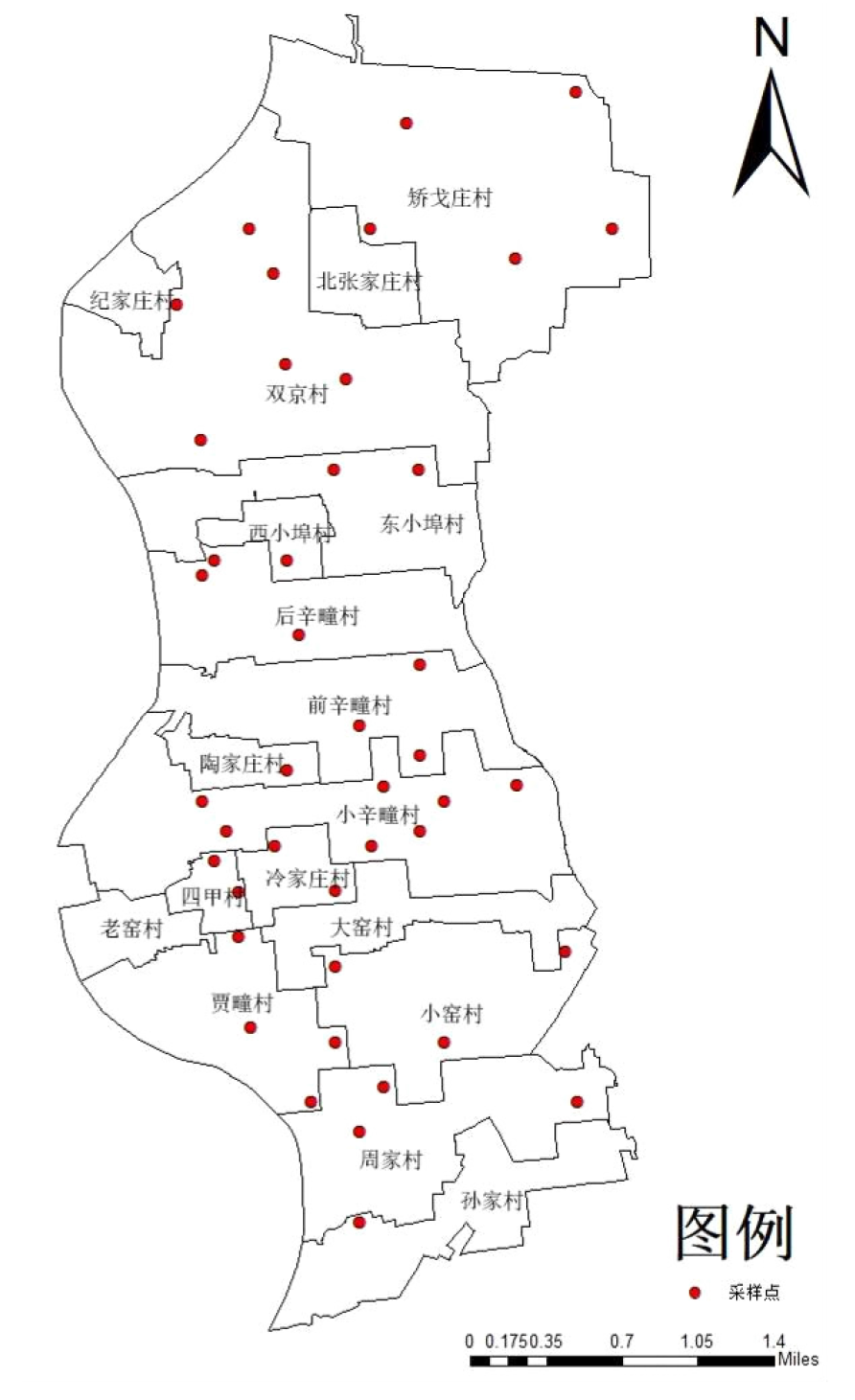
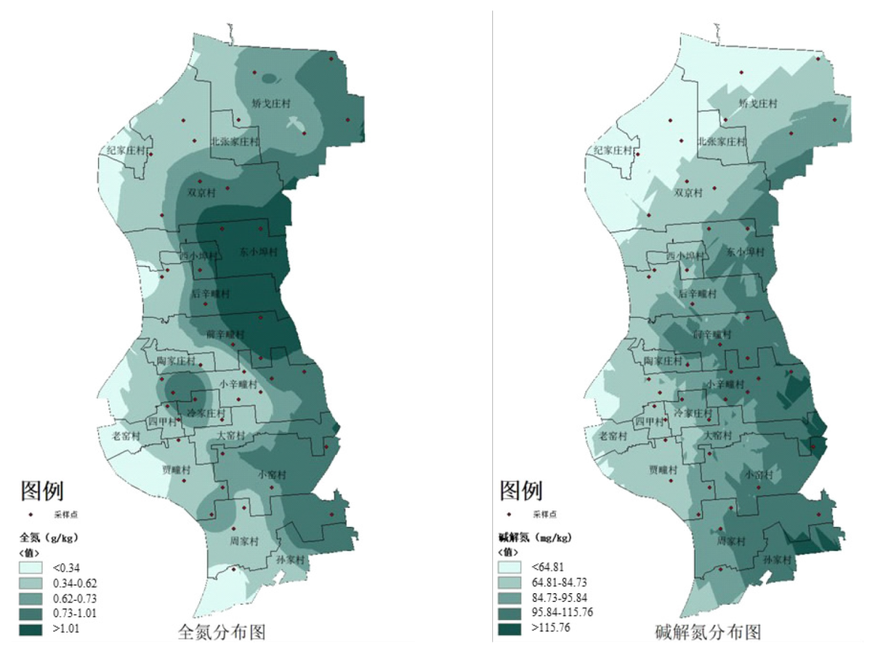
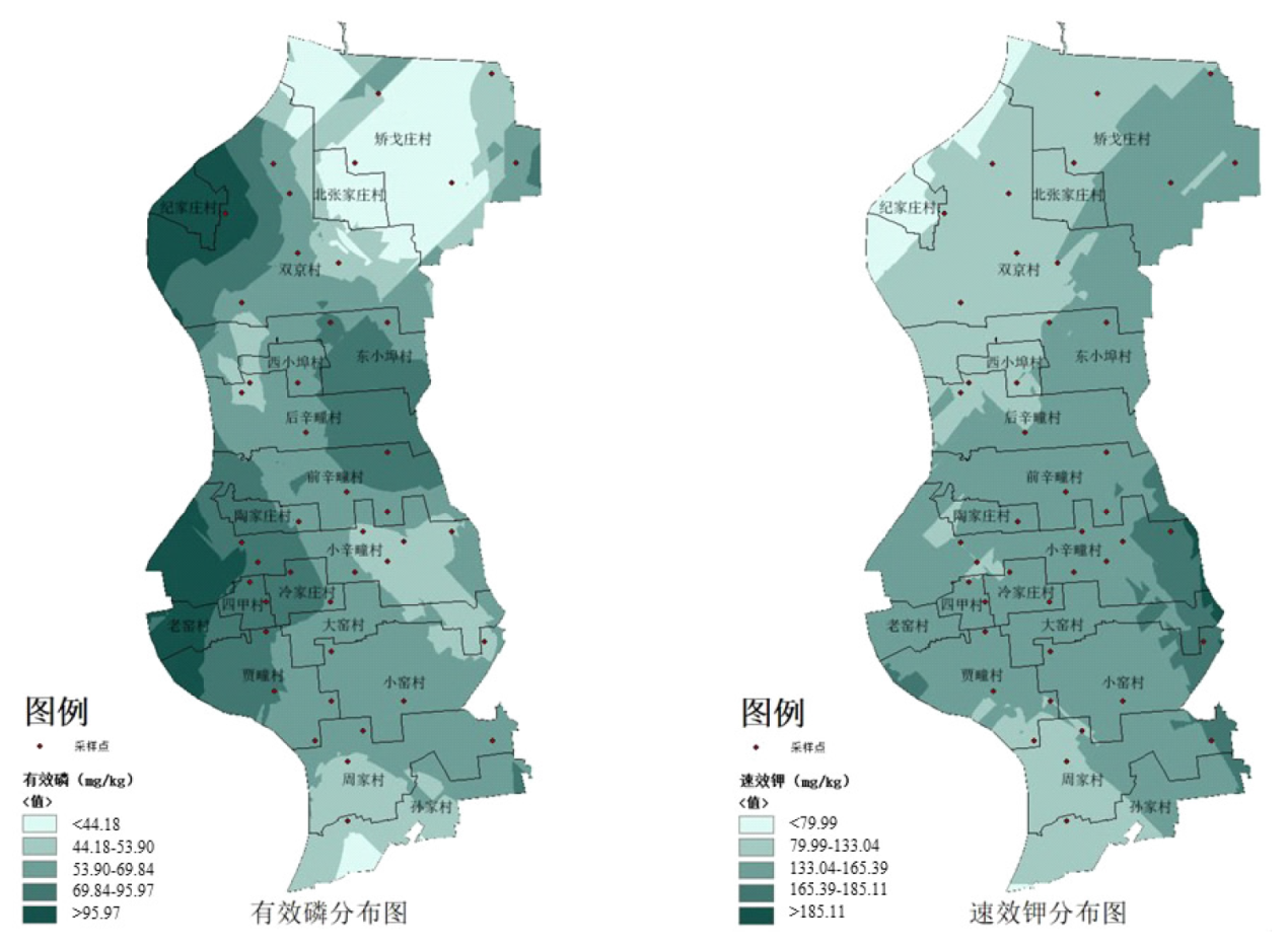
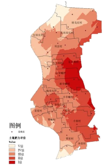
了解胶州市李哥庄镇北部18个村耕地土壤养分状况,为科学设置施肥方式和高标准农田建设中土壤改良工作提供参考依据。对研究区进行土壤养分含量检测,共设置43个采样点,测定土壤pH、有机质、全氮、碱解氮、有效磷、速效钾的含量。运用ArcGIS的普通克里金插值法分析研究区土壤养分空间分布特征,通过主成分分析法确定指标权重,通过指数和法划分土壤肥力等级并将结果可视化。结果表明:(1)研究区土壤主要呈酸性和中性;有机质、全氮、碱解氮含量缺乏,有效磷含量丰富,速效钾含量中等。(2)从空间分布特征看,pH呈南北低中部高,东侧低西侧高;有机质、全氮、碱解氮含量分布呈东侧高西侧低,表明三者具有显著相关性;有效磷分布呈东侧低西侧高;速效钾分布呈东侧高西侧低的特点。(3)Ⅰ、Ⅱ、Ⅲ、Ⅳ、Ⅴ级土地面积分别为365.11、545.80、803.71、547.93、390.85 hm2,占研究区总面积的13.76%、20.57%、30.29%、20.65%、14.73%。胶州市李哥庄镇北部18个村整体土壤肥力处于中等水平,土壤肥力呈现东侧丰富、西侧缺乏的特点。治理土壤酸化并提高有机质、全氮、碱解氮含量,对下一步建设高标准农田具有重要意义。
李佳欣, 盖伟玲, 孙显旻, 赵昕, 张晓光, 崔德杰. 基于GIS的土壤养分空间分布特征及肥力评价[J]. 中国农学通报, 2023, 39(25): 94-101.
LI Jiaxin, GAI Weiling, SUN Xianmin, ZHAO Xin, ZHANG Xiaoguang, CUI Dejie. Spatial Distribution Characteristics and Fertility Evaluation of Soil Nutrients Based on GIS[J]. Chinese Agricultural Science Bulletin, 2023, 39(25): 94-101.

| 丰缺状况 | 有机质/(g/kg) | 全氮/(g/kg) | 碱解氮/(mg/kg) | 有效磷/(mg/kg) | 速效钾/(mg/kg) |
|---|---|---|---|---|---|
| 极丰富 | > 40.00 | > 2.00 | > 150.00 | > 40.00 | > 200.00 |
| 丰富 | 30.00~40.00 | 1.50~2.00 | 120.00~150.00 | 20.00~40.00 | 150.00~200.00 |
| 中等 | 10.00~30.00 | 0.75~1.50 | 60.00~120.00 | 5.00~20.00 | 50.00~150.00 |
| 缺乏 | 6.00~10.00 | 0.50~0.75 | 30.00~60.00 | 3.00~5.00 | 30.00~50.00 |
| 极缺乏 | < 6.00 | < 0.50 | < 30.00 | < 3.00 | < 30.00 |
| 养分指标 | 范围 | 平均值 | 变异系数/% | 样品分布/% | ||||
|---|---|---|---|---|---|---|---|---|
| 极缺乏 | 缺乏 | 中等 | 丰富 | 极丰富 | ||||
| 有机质 | 1.45~24.72 g/kg | (9.63±4.30) g/kg | 44.67 | 23.26 | 32.56 | 44.19 | — | — |
| 全氮 | 0.27~1.85 g/kg | (0.71±0.30) g/kg | 42.71 | 18.60 | 39.53 | 39.54 | 2.33 | — |
| 碱解氮 | 29.13~227.40 mg/kg | (93.47±46.14) mg/kg | 49.37 | 2.33 | 25.58 | 48.84 | 11.63 | 11.63 |
| 有效磷 | 5.70~193.50 mg/kg | (63.42±34.96) mg/kg | 55.13 | — | — | 4.66 | 20.93 | 74.42 |
| 速效钾 | 52.76~305.70 mg/kg | (137.99±47.23) mg/kg | 34.23 | — | — | 67.44 | 23.26 | 9.30 |


| 养分指标 | 权重 | 极丰富(强碱性) | 丰富(碱性) | 中等(中性) | 缺乏(酸性) | 极缺乏(强酸性) |
|---|---|---|---|---|---|---|
| pH | 0.0131 | — | — | 100 | 70 | 40 |
| 有机质 | 0.1923 | 100 | 80 | 60 | 40 | 20 |
| 全氮 | 0.2073 | 100 | 80 | 60 | 40 | 20 |
| 碱解氮 | 0.1810 | 100 | 80 | 60 | 40 | 20 |
| 有效磷 | 0.1892 | 100 | 80 | 60 | 40 | 20 |
| 速效钾 | 0.2160 | 100 | 80 | 60 | 40 | 20 |

| [1] |
徐明岗, 卢昌艾, 张文菊, 等. 我国耕地质量状况与提升对策[J]. 中国农业资源与区划, 2016, 37(7):8-14.
|
| [2] |
郭安廷, 崔锦霞, 许鑫, 等. 基于GIS与地统计的土壤养分空间变异研究[J]. 中国农学通报, 2018, 34(23):72-79.
doi: 10.11924/j.issn.1000-6850.casb17070049 |
| [3] |
doi: 10.2136/sssaj2011.0206 URL |
| [4] |
厉雅华, 张向前, 安祺, 等. 耕地地力评价方法及实践应用研究进展[J]. 中国农学通报, 2022, 38(15):60-68.
doi: 10.11924/j.issn.1000-6850.casb2021-0610 |
| [5] |
耿庆龙, 李娜, 赖宁, 等. 基于修正内梅罗指数法的果园土壤肥力评价[J]. 新疆农业科学, 2019, 56(11):2104.
|
| [6] |
|
| [7] |
|
| [8] |
赖宁, 陈署晃, 付彦博, 等. 基于GIS的南疆果园土壤肥力评价[J]. 新疆农业科学, 2019, 56(8):1476-1486.
doi: 10.6048/j.issn.1001-4330.2019.08.012 |
| [9] |
孟博, 周一帆, 杨林生, 等. 勐海县甘蔗土壤养分空间分布特征及肥力评价[J]. 土壤, 2022, 54(2):277-284.
|
| [10] |
孙宇, 高明, 王丹, 等. 基于GIS和改进灰色关联模型的岩溶区土壤肥力评价——以重庆市丰都县岩溶区为例[J]. 中国岩溶, 2014, 33(3):347-355.
|
| [11] |
王珊珊. 山东省青岛市胶州市李哥庄镇特色小镇建设纪实——空港小镇生态新城[J]. 小城镇建设, 2016(11):83-86.
|
| [12] |
楼晨. 新中国农田建设历程刍议[J]. 农村工作通讯, 2021(20):4.
|
| [13] |
邓亚中. 《全国高标准农田建设规划(2021—2030年)》解读——提高国家粮食综合生产能力[J]. 河北农机, 2022(6):157-159.
|
| [14] |
鲍士旦. 土壤农化分析(3版)[M]. 北京: 中国农业出版社, 2000.
|
| [15] |
石媛媛, 郑党斌, 岑祖明, 等. 广西雅长林场林地养分空间分布及肥力评价[J]. 福建林业科技, 2022, 49(1):21-29.
|
| [16] |
冯卓亚. 基于GIS的耕地质量评价研究[D]. 北京: 华北水利水电大学, 2021.
|
| [17] |
赵秀红. 基于主成分分析的特征提取的研究[D]. 西安: 西安电子科技大学, 2016.
|
| [18] |
聂群海. 基于GIS技术和主成分分析的苏州土地适宜性评价与应用[D]. 苏州: 苏州大学, 2017.
|
| [19] |
赵慧琴, 石立, 刘金山, 等. SPSS软件计算主成分分析的缺陷与纠正[J]. 统计与决策, 2020, 36(15):56-59.
|
| [20] |
曹文涛. 基于野外实测光谱监测的潍北地区土壤盐分含量研究[D]. 济南: 山东师范大学, 2017.
|
| [21] |
doi: 10.1080/00103629409369010 URL |
| [22] |
肖特, 崔阔澍, 黄文娟, 等. 玉米/大豆不同种植模式对土壤有机质和全氮空间分布的影响[J]. 草地学报, 2022, 30(7):1801-1810.
doi: 10.11733/j.issn.1007-0435.2022.07.022 |
| [23] |
王风芹, 田丽青, 宋安东, 等. 华北刺槐林与自然恢复植被土壤微生物量碳、氮含量四季动态[J]. 林业科学, 2015(3):16-24.
|
| [24] |
doi: 10.1016/j.geoderma.2009.11.020 URL |
| [25] |
崔帅, 刘烁然, 王寅, 等. 吉林省旱地土壤有效硫含量及其与土壤有机质和全氮的关系[J]. 中国农业科学, 2022, 55(12):12.
|
| [26] |
王慧, 刘金山, 惠晓丽, 等. 旱地土壤有机碳氮和供氮能力对长期不同氮肥用量的响应[J]. 中国农业科学, 2016, 49(15):2988-2998.
doi: 10.3864/j.issn.0578-1752.2016.15.013 |
| [27] |
朱梓弘, 朱同彬, 杨霖, 等. 中国土壤碱解氮含量与影响因子的空间关系研究[J]. 生态环境学报, 2019, 28(11):2199-2207.
doi: 10.16258/j.cnki.1674-5906.2019.11.008 |
| [28] |
尹嘉德, 侯慧芝, 张绪成, 等. 化肥与有机肥结合对旱地覆膜春小麦产量形成和土壤碱解氮累积影响[J]. 水土保持学报, 2021, 35(2):279-287.
|
| [29] |
潘根兴, 丁元君, 陈硕桐, 等. 从土壤腐殖质分组到分子有机质组学认识土壤有机质本质[J]. 地球科学进展, 2019, 34(5):451-470.
doi: 10.11867/j.issn.1001-8166.2019.05.0451 |
| [30] |
江叶枫, 叶英聪, 郭熙, 等. 南方红壤区不同侵蚀程度下耕地土壤有效磷空间分布特征及其驱动因素[J]. 土壤, 2018, 50(5):1013-1021.
|
| [31] |
曹婧, 陈怡平, 江瑶, 等. 陕西省农田土壤速效钾时空变化及其影响因素[J]. 水土保持学报, 2021, 35(5):296-302,311.
|
| [32] |
赵秀东, 陈晓芳, 袁自然, 等. 有机肥替代对土壤养分的影响[J]. 中国农学通报, 2022, 38(16):74-80.
doi: 10.11924/j.issn.1000-6850.casb2021-0611 |
| [33] |
郭军玲, 王永亮, 郭彩霞, 等. 基于GIS和测土配方数据的晋北县域春玉米专用肥配方筛选[J]. 农业工程学报, 2016, 34(7):158-164.
|
| [1] | 吴楚鹏, 盛建东, 胡雨彤, 成志慧, 杨鹏飞. 新疆沙雅县绿洲棉田土壤质量评价[J]. 中国农学通报, 2023, 39(9): 71-78. |
| [2] | 沈建国, 粟贵俊, 楼玲, 何林海, 胡康赢. 洗盐方式对设施土壤盐分、养分含量及蔬菜生长的影响[J]. 中国农学通报, 2023, 39(8): 69-73. |
| [3] | 杨明霞, 刁珊, 崔克强, 赵士粤, 任瑞, 何美美, 纪薇. 基于主成分分析的山楂果实贮藏性能研究[J]. 中国农学通报, 2023, 39(7): 135-139. |
| [4] | 贾晓昀, 赵红霞, 朱继杰, 王国印, 李妙, 王士杰. 陆地棉资源主要产量和纤维品质性状的遗传多样性分析研究[J]. 中国农学通报, 2023, 39(6): 35-40. |
| [5] | 谢坤豪, 石奡坤, 狄清华, 陈茹, 李衍素, 于贤昌, 陈双臣, 贺超兴. 蔬菜残株堆肥还田对生姜产量及根区土壤环境的影响[J]. 中国农学通报, 2023, 39(5): 87-91. |
| [6] | 陈桢禄, 潘晓英, 卢钰升, 黄振瑞, 顾文杰, 郭俊杰, 魏彬, 曾瑜玲, 刘意旋, 何经纬, 李集勤. 有机无机复配调理剂对酸化土壤性状和烟叶产质量的影响[J]. 中国农学通报, 2023, 39(3): 28-34. |
| [7] | 刘小婷, 王京文, 杨文叶, 张奇春. 配施有机替代肥及缓控肥对稻田土壤肥力的影响[J]. 中国农学通报, 2023, 39(25): 77-83. |
| [8] | 陈检锋, 尹梅, 陈华, 王志远, 王伟, 王应学, 杨艳鲜, 付利波. 云南莴笋高产养分临界值施肥模型研究[J]. 中国农学通报, 2023, 39(25): 89-93. |
| [9] | 韩晓飞, 李潇然, 王俊伟. 沼液替代化肥对露地萝卜产量、品质和土壤理化性质的影响[J]. 中国农学通报, 2023, 39(22): 34-39. |
| [10] | 陈睿, 鲜小林, 李世峰. 14种高山杜鹃夏季生长量的比较研究[J]. 中国农学通报, 2023, 39(22): 65-71. |
| [11] | 袁文彬, 黄浩, 关罗浩, 李超, 王文辉, 谢丹凤, 杨天旭, 王维. 会理烟区烤烟质量特征的区域归类研究[J]. 中国农学通报, 2023, 39(22): 96-103. |
| [12] | 李婷, 朱立安, 林梓, 邵社刚, 倪栋, 林兰稳. 土壤改良剂(CMC)在新垦耕地土壤改良中的应用[J]. 中国农学通报, 2023, 39(21): 88-93. |
| [13] | 杜健, 潘雪, 武均, 蔡立群. 地块尺度下青海省都兰县耕地土壤养分的空间自相关分析[J]. 中国农学通报, 2023, 39(21): 94-102. |
| [14] | 罗毅, 张雪, 佘新松, 庄敏, 苏敏, 胡长玉, 田原. 香榧林下复合种植模式对皖南山区土壤养分保持的影响[J]. 中国农学通报, 2023, 39(20): 51-59. |
| [15] | 姜冰, 王松涛, 孙增兵, 张海瑞, 王建, 刘阳. 基于隶属度函数和主成分分析的耕地土壤肥力评价[J]. 中国农学通报, 2023, 39(2): 22-27. |
| 阅读次数 | ||||||
|
全文 |
|
|||||
|
摘要 |
|
|||||