欢迎访问《中国农学通报》,
中国农学通报 ›› 2023, Vol. 39 ›› Issue (31): 96-105.doi: 10.11924/j.issn.1000-6850.casb2022-0832
丁吉达( ), 蒲智(), 唐芳, 田永强
收稿日期:2022-10-06
修回日期:2023-05-10
出版日期:2023-11-05
发布日期:2023-10-31
通讯作者:
蒲智,男,1975年出生,甘肃天水人,副教授,博士,主要从事环境生态遥感研究。通信地址:830052 新疆乌鲁木齐市沙依巴克区农大东路311号 新疆农业大学,E-mail:869831699@qq.com。
作者简介:丁吉达,男,1997年出生,山东临沂人,硕士研究生,主要从事遥感土地利用研究。通信地址:830052 新疆乌鲁木齐市沙依巴克区农大东路311号 新疆农业大学,E-mail:1051460577@qq.com。
基金资助:
DING Jida(), PU Zhi(), TANG Fang, TIAN Yongqiang
Received:2022-10-06
Revised:2023-05-10
Published-:2023-11-05
Online:2023-10-31
摘要:
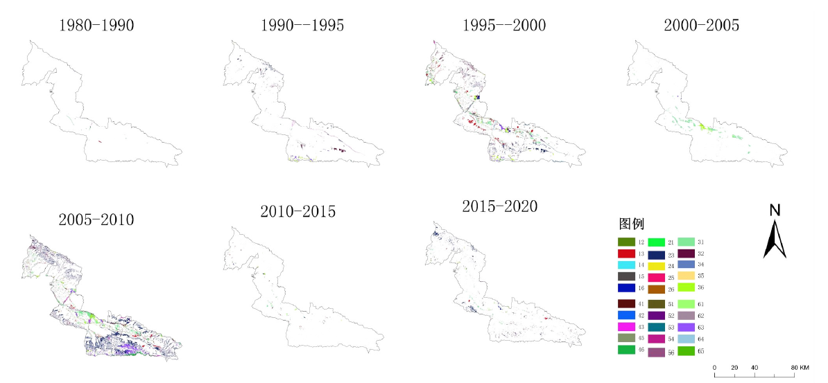
为研究天山野果林分布区域的土地利用变化问题,基于天山野果林分布区1980—2020年8期土地利用数据,构建7个时序的土地利用地学信息图谱体系,分析天山野果林分布区土地利用变化时空特征。结果表明:(1)天山野果林分布区土地利用结构以草地和耕地为主,占总面积的80%左右。(2)土地利用变化图谱以林地、草地之间的相互转变及耕地增加为主,其他地类总体变化较小。(3)土地利用涨落势图谱中草地净增长最大,其次为耕地;林地萎缩最为严重,后期呈断崖式下降。(4)土地利用变化模式图谱以稳定不变型为主,其次为后期变化型,全期变化型占比最小;土地利用后期变化相比前期更为频繁。(5)土地利用变化频率图谱以稳定不变区域为主,其次为低频区域,两者占比大于98%,故土地利用结构总体较为稳定。研究分析天山野果林分布区土地利用时空演变的特征,揭示研究区土地利用变化规律,可为天山野果林资源优化调度提供依据。
丁吉达, 蒲智, 唐芳, 田永强. 天山野果林分布区土地利用时空演变图谱研究[J]. 中国农学通报, 2023, 39(31): 96-105.
DING Jida, PU Zhi, TANG Fang, TIAN Yongqiang. Spatial and Temporal Evolution of Land Use in the Distribution Area of Tianshan Wild Fruit Forest[J]. Chinese Agricultural Science Bulletin, 2023, 39(31): 96-105.
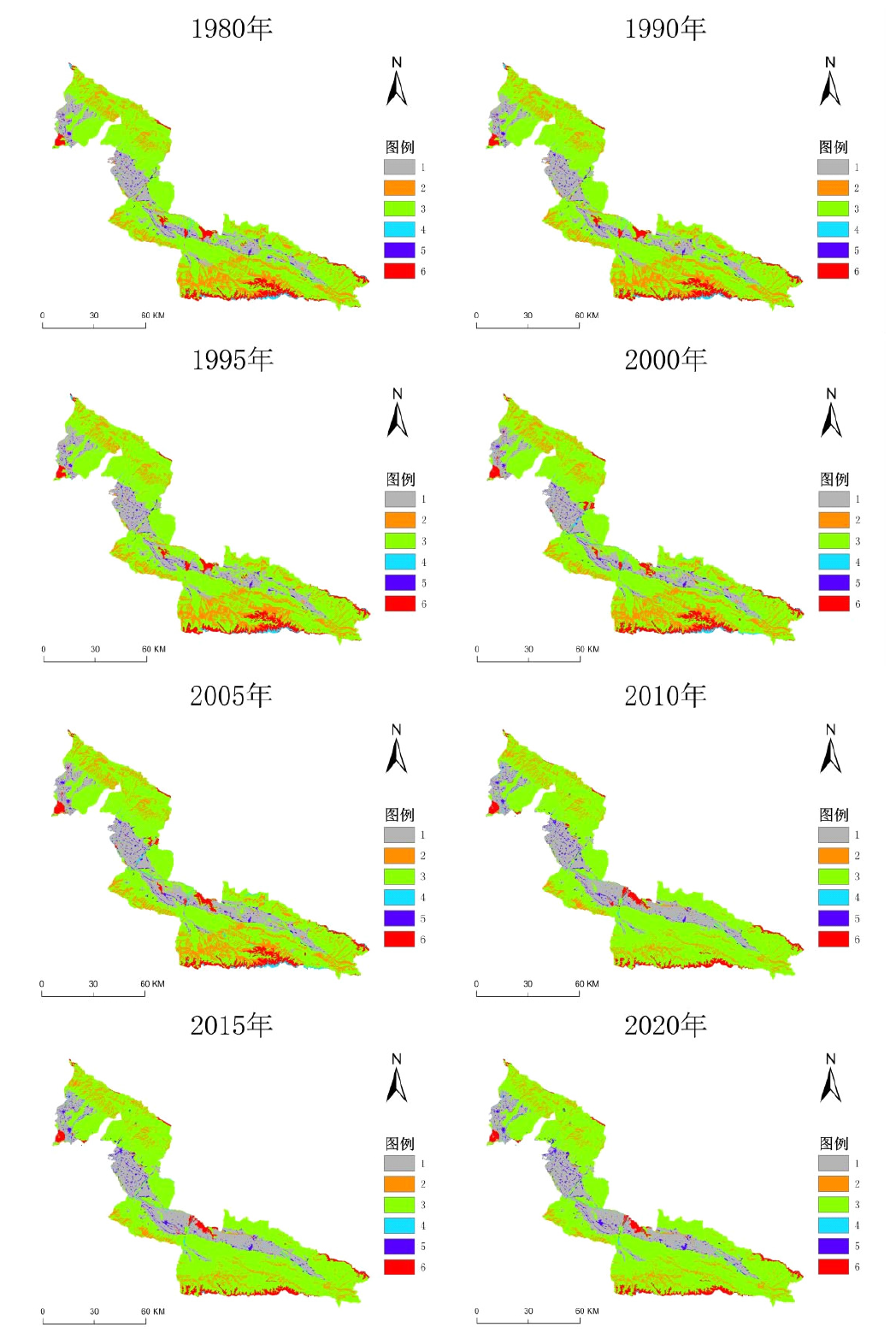
| 利用类型 | 1980年 | 1990年 | 1995年 | 2000年 | 2005年 | 2010年 | 2015年 | 2020年 |
|---|---|---|---|---|---|---|---|---|
| 草地 | 61.38 | 61.34 | 61.61 | 61.06 | 59.11 | 66.18 | 65.94 | 66.32 |
| 耕地 | 16.39 | 16.47 | 16.47 | 16.20 | 17.99 | 19.61 | 19.65 | 19.94 |
| 建设用地 | 1.56 | 1.56 | 1.56 | 1.63 | 1.64 | 1.91 | 2.13 | 2.26 |
| 林地 | 14.44 | 14.46 | 14.50 | 14.20 | 14.23 | 7.59 | 7.56 | 6.90 |
| 水域 | 1.04 | 0.97 | 0.71 | 1.54 | 1.55 | 0.73 | 0.76 | 0.73 |
| 未利用地 | 5.20 | 5.21 | 5.15 | 5.37 | 5.48 | 3.99 | 3.96 | 3.86 |
| 编码 | 土地利用变化 | 1980—1990 | 1990—1995 | 1995—2000 | 2000—2005 | 2005—2010 | 2010—2015 | 2015—2020 |
|---|---|---|---|---|---|---|---|---|
| 31 | 草地→耕地 | 43.20 | 0.48 | 15.44 | 65.94 | 12.01 | 23.03 | 14.47 |
| 35 | 草地→建设用地 | 0.07 | 0.05 | 0.56 | 0.24 | 0.98 | 6.19 | 2.49 |
| 32 | 草地→林地 | 2.66 | 26.78 | 13.97 | 4.32 | 8.42 | 9.95 | 17.04 |
| 34 | 草地→水域 | 0.12 | 0.03 | 5.95 | 0.37 | 0.85 | 3.05 | 0.66 |
| 36 | 草地→未利用地 | 1.10 | 11.84 | 7.34 | 13.73 | 3.11 | 3.73 | 0.71 |
| 13 | 耕地→草地 | 11.44 | 0.56 | 15.95 | 0.49 | 5.12 | 10.81 | 6.06 |
| 15 | 耕地→建设用地 | 2.09 | 1.36 | 4.54 | 0.59 | 2.83 | 12.74 | 4.98 |
| 16 | 耕地→未利用地 | 0.03 | 0.04 | 2.75 | 0.07 | 0.15 | 2.76 | 2.07 |
| 51 | 建设用地→耕地 | 1.11 | 1.26 | 3.52 | 0.24 | 2.22 | 1.69 | 2.92 |
| 23 | 林地→草地 | 3.08 | 25.91 | 15.06 | 3.08 | 40.81 | 11.18 | 36.92 |
| 21 | 林地→耕地 | 0.04 | 0.37 | 1.79 | 0.27 | 1.12 | 0.37 | 0.14 |
| 43 | 水域→草地 | 12.09 | 10.43 | 0.39 | 0.18 | 2.41 | 1.02 | 1.01 |
| 45 | 水域→建设用地 | 6.39 | 0.09 | 0.00 | 0.00 | 0.04 | 0.07 | 0.09 |
| 42 | 水域→林地 | 8.08 | 1.54 | 0.09 | 0.09 | 0.35 | 0.32 | 0.29 |
| 63 | 未利用地→草地 | 4.47 | 15.85 | 5.34 | 1.65 | 12.22 | 1.00 | 1.16 |
| 61 | 未利用地→耕地 | 0.15 | 0.03 | 1.10 | 7.42 | 1.38 | 5.88 | 3.66 |

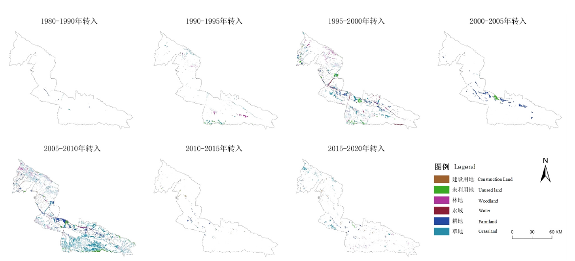
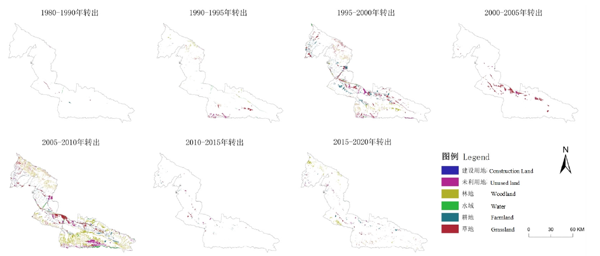
| 时段 | 项目 | 耕地 | 林地 | 草地 | 水域 | 建设用地 | 未利用地 |
|---|---|---|---|---|---|---|---|
| 1980—1990 | 转出量 | 8.63 | 1.67 | 24.44 | 13.78 | 0.67 | 2.67 |
| 转入量 | 23.09 | 1.60 | 16.15 | 6.27 | 1.13 | 4.81 | |
| 1990—1995 | 转出量 | 8.22 | 102.23 | 148.43 | 51.05 | 7.66 | 61.27 |
| 转入量 | 8.17 | 109.98 | 200.85 | 0.32 | 8.83 | 50.71 | |
| 1995—2000 | 转出量 | 451.92 | 332.42 | 790.98 | 17.78 | 83.48 | 152.07 |
| 转入量 | 401.54 | 276.21 | 685.95 | 175.76 | 95.74 | 193.44 | |
| 2000—2005 | 转出量 | 6.00 | 17.11 | 396.78 | 2.55 | 1.58 | 44.99 |
| 转入量 | 346.63 | 21.63 | 25.60 | 4.75 | 4.04 | 66.35 | |
| 2005—2010 | 转出量 | 337.68 | 1609.17 | 955.85 | 231.06 | 105.25 | 527.85 |
| 转入量 | 644.90 | 347.33 | 2300.23 | 74.82 | 156.42 | 243.18 | |
| 2010—2015 | 转出量 | 60.67 | 26.52 | 99.21 | 5.32 | 4.42 | 19.83 |
| 转入量 | 68.13 | 22.53 | 52.46 | 11.94 | 45.80 | 15.11 | |
| 2015—2020 | 转出量 | 86.82 | 237.90 | 225.54 | 16.09 | 31.58 | 39.73 |
| 转入量 | 141.58 | 111.82 | 299.19 | 9.53 | 55.77 | 19.75 | |
| 统计 | 总转出量 | 959.95 | 2327.02 | 2641.24 | 337.63 | 234.64 | 848.41 |
| 总转入量 | 1634.05 | 891.11 | 3580.42 | 283.40 | 367.73 | 593.35 | |
| 总净转入量 | 674.10 | -1435.91 | 939.19 | -54.23 | 133.09 | -255.06 |

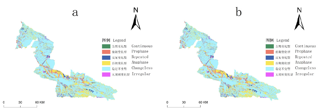
| 模式图谱 | 面积/km2 | 比例/% | 最大变化 | ||
|---|---|---|---|---|---|
| 最大图谱单元类型 | 面积/km2 | 比例/% | |||
| 稳定不变型 | 13506.0887 | 71.089981 | 草地 | 9665.1448 | 50.87297 |
| 全期变化型 | 0.0012 | 0.000006 | 建设用地-草地-建设用地-草地-耕地-草地-未利用地-草地 | 0.0009 | 0.000005 |
| 反复变化型 | 992.3761 | 5.223422 | 草地-草地-草地-草地-草地-林地-林地-草地 | 92.0568 | 0.484546 |
| 后期变化型 | 3629.3041 | 19.103026 | 林地-林地-林地-林地-林地-草地-草地-草地 | 1303.7297 | 6.862247 |
| 前期变化型 | 943.1667 | 4.964406 | 草地-草地-草地-耕地-耕地-耕地-耕地-耕地 | 207.3130 | 1.091202 |
| 无规则变化型 | 382.6690 | 2.014153 | 林地-林地-草地-林地-林地-草地-草地-草地 | 51.8052 | 0.272673 |
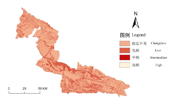
| 频率图谱 | 变化次数 | 面积/km2 | 最大变化 | ||
|---|---|---|---|---|---|
| 最大图谱单元类型 | 面积/km2 | 比例/% | |||
| 稳定不变 | 0 | 13511.61 | 草地 | 9665.14 | 50.8730 |
| 低频 | 1~2 | 5184.75 | 林地-林地-林地-林地-林地-草地-草地-草地 | 1303.73 | 6.8622 |
| 中频 | 3~4 | 297.71 | 未利用地-未利用地-草地-未利用地-未利用地-草地-草地-草地 | 29.34 | 0.1544 |
| 高频 | 5~7 | 1.69 | 水域-水域-草地-水域-水域-草地-水域-草地 | 0.40 | 0.0021 |
| [1] |
李秀彬. 全球环境变化研究的核心领域——土地利用/土地覆被变化的国际研究动向[J]. 地理学报, 1996, 51(6):553-558.
doi: 10.11821/xb199606009 |
| [2] |
郭荣中, 申海建, 杨敏华. 基于GM(1,1)模型的长株潭地区土地覆被变化分析及趋势预测[J]. 湖北农业科学, 2020, 59(16):54-60.
|
| [3] |
|
| [4] |
段宝玲, 卜玉山. 山西省土地利用动态特征及驱动因素分析[J]. 山西农业大学学报(自然科学版), 2018(3):43-51
|
| [5] |
徐国印, 王忠静, 胡智丹, 等. 柴达木盆地土地利用/覆被综合指数评价[J]. 水力发电学报, 2019(9):44-55
|
| [6] |
李娟, 李振林. 基于GIS空间分析的县域国土空间开发适宜性评价[J]. 地理空间信息, 2021, 19(9):57-60.
|
| [7] |
华琳, 黄志霖, 马良, 等. 三峡库区低山丘陵区多尺度景观指数响应及适宜粒度[J]. 生态学报, 2022, 42(11):4703-4717.
|
| [8] |
|
| [9] |
|
| [10] |
赵静. 基于地学信息图谱的龙口市土地利用动态变化研究[J]. 山东国土资源, 2011, 27(1):29-32.
|
| [11] |
关昕昕. 专家支招, 破解新疆天山野果林保护与修复难题[J]. 新疆林业, 2019(1):29,33.
|
| [12] |
张道远, 张元明, 管开云. 野果林的最后避难所[J]. 人与生物圈, 2020(5):14-15.
|
| [13] |
许正. 新疆伊犁野果林野生果树与近缘种资源及其分布[A].// 中国园艺学会.全国首届野生果树资源与开发利用学术研讨会论文汇编[C]. 2004:150-156.
|
| [14] |
李建伟, 罗志娜, 张生楹, 等. 2016年-2020年新源县不同草地类草原载畜量的变化及经济效益分析[J]. 草食家畜, 2021(3):30-38.
|
| [15] |
徐新良, 刘纪远, 张树文, 等. 中国多时期土地利用土地覆被遥感监测数据集(CNLUCC)[Z]. 中国科学院资源环境科学数据中心数据注册与出版系统.
|
| [16] |
张红, 马丽. 1972—2018年策勒绿洲耕地时空演变及驱动力分析[J]. 河北环境工程学院学报, 2021, 31(6):37-41.
|
| [17] |
张文慧, 吕晓, 史洋洋, 等. 黄河流域土地利用转型图谱特征[J]. 中国土地科学, 2020, 34(8):80-88.
|
| [18] |
刘欣, 朱苏加, 赵艳霞, 等. 河北浅山区土地利用时空演变图谱特征及地形效应[J]. 地理与地理信息科学, 2020, 36(4):94-101.
|
| [19] |
田立鑫, 韩美, 王敏, 等. 莱州湾南岸海岸带土地利用时空演变及稳定性研究[J]. 水土保持研究, 2021, 28(4):259-265,274.
|
| [20] |
邓振华, 张晶, 于明洋, 等. 济南南部山区土地利用的时空变化分析[J]. 首都师范大学学报(自然科学版), 2010, 31(1):69-73,79.
|
| [21] |
于元赫, 李子君, 林锦阔, 等. 沂河流域土地利用时空变化图谱特征分析[J]. 自然资源学报, 2019, 34(5):975-988.
doi: 10.31497/zrzyxb.20190506 |
| [22] |
刘月阳, 杜崇, 龚文峰, 等. 基于地学图谱的县级尺度土地利用时空变化特征研究——以酉阳土家族苗族自治县为例[J]. 中国农学通报, 2021, 37(14):123-135.
doi: 10.11924/j.issn.1000-6850.casb2020-0241 |
| [23] |
张韵, 彭建东, 王晶晶, 等. 基于地学信息图谱的江汉平原土地利用时空变化分析[J]. 水土保持研究, 2020, 27(4):85-92.
|
| [24] |
杜崇, 刘月阳, 郭显锋, 等. 基于地学信息图谱肇州县土地利用时空变化分析研究[J]. 水利科学与寒区工程, 2020, 3(2):11-15.
|
| [25] |
孙丕苓, 许月卿, 王数. 环京津贫困带土地利用变化的地形梯度效应分析[J]. 农业工程学报, 2014, 30(14):277-288.
|
| [26] |
吕晓, 史洋洋, 黄贤金, 等. 江苏省土地利用变化的图谱特征[J]. 生态学杂志, 2016, 27(4):1077-1084.
|
| [27] |
杨爱民, 朱磊, 陈署晃, 等. 1975—2015年玛纳斯河流域土地利用变化的地学信息图谱分析[J]. 应用生态学报, 2019, 30(11):3863-3874.
doi: 10.13287/j.1001-9332.201911.017 |
| [1] | 田婷, 张青, 徐雯. 基于无人机多光谱影像的水稻冠层SPAD值预测研究[J]. 中国农学通报, 2023, 39(4): 149-153. |
| [2] | 李雪梅, 舒英格. 不同土地利用类型下土壤养分变化及生态化学计量特征分析[J]. 中国农学通报, 2023, 39(28): 62-69. |
| [3] | 张金峰, 陈农, 闫敏慧, 徐占胜, 杨宁, 高玲, 吕欣陆. 基于DEM的黑龙江省10℃界限温度时空变化特征分析[J]. 中国农学通报, 2023, 39(27): 81-85. |
| [4] | 刘佳宁, 孙丽娜. 1980—2020年黑龙江省土地利用碳排放时空分异研究[J]. 中国农学通报, 2023, 39(26): 86-97. |
| [5] | 王嘉浩, 肖洋, 张瑞豪, 王艳, 牛羽萱, 贺旭杨. 克东县2000—2020年植被覆盖变化分析[J]. 中国农学通报, 2023, 39(24): 77-83. |
| [6] | 李煜婧, 夏紫祎, 申桐, 王斐, 郑磊, 周建利, 张强, 孙楠, 徐明岗. 烟台市典型县域土壤pH时空变化特征及影响因素[J]. 中国农学通报, 2023, 39(21): 103-108. |
| [7] | 管雅芳, 焦阳, 臧传富. 韩江流域土地利用时空变化特征及其生态安全评估[J]. 中国农学通报, 2023, 39(20): 91-99. |
| [8] | 张娟, 廖菊阳, 刘艳, 王玲, 李巧云, 吴林世, 黄雅奇. 多源遥感数据在森林资源监测上的应用现状与发展趋势[J]. 中国农学通报, 2023, 39(19): 159-164. |
| [9] | 汤萌萌, 江文娟, 丁琪洵, 王强, 马友华. 基于高分辨率遥感的耕地质量指标与评价进展[J]. 中国农学通报, 2023, 39(16): 131-136. |
| [10] | 刘兆旭, 刘晶, 郑国宏, 李建刚. 博尔塔拉蒙古自治州土地/植被覆盖变化及驱动力分析[J]. 中国农学通报, 2023, 39(16): 68-76. |
| [11] | 白玛仁增, 顿玉多吉, 德例归吉, 德吉央宗, 益西多吉, 边巴次仁. 星-地结合对水稻高温热害监测模型的研究[J]. 中国农学通报, 2023, 39(1): 133-141. |
| [12] | 薛文瑞, 杨自辉, 张永, 郭树江, 王强强, 张剑挥. 民勤荒漠绿洲植被覆盖对地下水和降水变化的响应[J]. 中国农学通报, 2022, 38(8): 102-109. |
| [13] | 孙喜军, 邓睿, 吕爽, 高莹, 蔡苗, 缑巧红, 赵娟. 西安市农用地土壤有机质空间变异特征[J]. 中国农学通报, 2022, 38(35): 43-53. |
| [14] | 田雨桐, 韩志伟, 赵然, 田永著, 罗广飞, 杨淼. 西南岩溶农业区典型土地利用对土壤氮素特征的影响[J]. 中国农学通报, 2022, 38(33): 89-96. |
| [15] | 高琳, 胡晋豪, 汪志超, 林昌华, 冯慧敏. 粤北山区县域土地利用对生态服务价值的影响[J]. 中国农学通报, 2022, 38(32): 69-77. |
| 阅读次数 | ||||||
|
全文 |
|
|||||
|
摘要 |
|
|||||