欢迎访问《中国农学通报》,
中国农学通报 ›› 2023, Vol. 39 ›› Issue (16): 68-76.doi: 10.11924/j.issn.1000-6850.casb2022-0914
刘兆旭1( ), 刘晶2, 郑国宏1(), 李建刚2
收稿日期:2022-11-01
修回日期:2023-04-04
出版日期:2023-06-05
发布日期:2023-05-22
通讯作者:
郑国宏,男,1973年出生,新疆乌鲁木齐人,高级工程师,硕士研究生,主要从事环境遥感研究。通信地址:830002 新疆乌鲁木齐建国路327号 新疆气象局,Tel:0991-2663996,E-mail:作者简介:刘兆旭,男,1983年出生,新疆乌鲁木齐人,工程师,本科,主要从事环境遥感以及防灾减灾工作。通信地址:830002 新疆乌鲁木齐建国路327号 新疆气象局,Tel:0991-2634055,E-mail:847592455@qq.com。
基金资助:
LIU Zhaoxu1(), LIU Jing2, ZHENG Guohong1(), LI Jiangang2
Received:2022-11-01
Revised:2023-04-04
Online:2023-06-05
Published:2023-05-22
摘要:
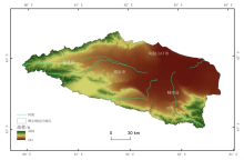
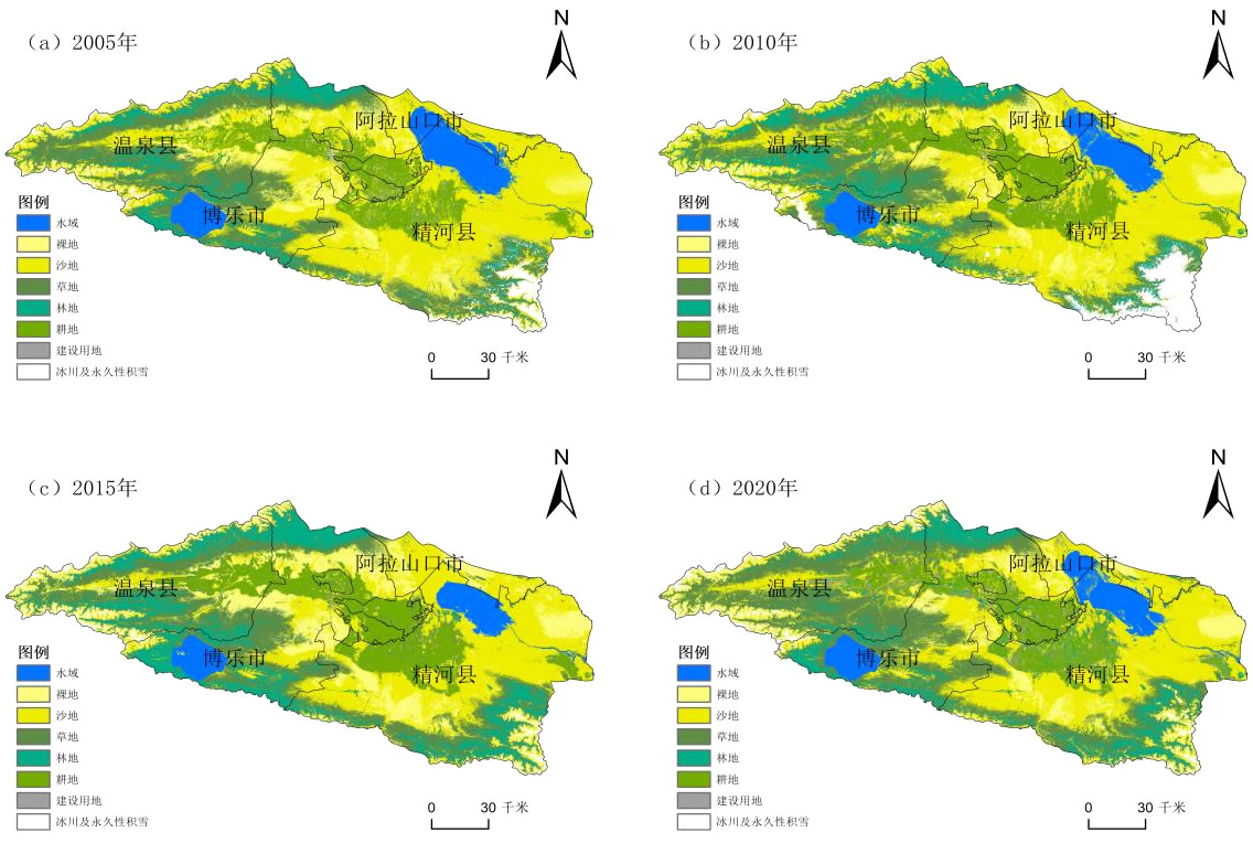
博尔塔拉蒙古自治州(简称博州地区)处于准噶尔盆地西南边缘,是西北荒漠区的典型代表,是大风的主风道,是重要的风沙策源地,生态比较脆弱。本研究基于30 m空间分辨率的Landsat数据,结合土地利用矩阵转移,分析2005—2020年博州地区土地利用变化特征、植被覆盖度及驱动力因素。结果表明:(1)2005—2020年,博州地区的主要地类是沙地、草地、裸地和耕地。沙地面积增加1447 km2,增长率为18%;草地面积减少最多,减少了1638 km2。2000—2015年博州地区有大量的沙地、林地、耕地转为草地,建设用地也在微弱增加。(2)2005—2020年博州地区低植被覆盖度面积占比相当高,超过了60%,较低植被覆盖度的实际比例均在10%,中覆盖度植被呈现增长的趋势,而较高和高覆盖度的植被呈现出先大幅增加后缓慢减少的趋势,植被的覆盖度伴随坡度的提高先降后升再降。(3)由驱动力的研究发现,土地利用变化是引起植被覆盖度变化的首要影响因子,其次是道路和GDP,再次是降水和温度,最后是人口密度、水系和坡度。
刘兆旭, 刘晶, 郑国宏, 李建刚. 博尔塔拉蒙古自治州土地/植被覆盖变化及驱动力分析[J]. 中国农学通报, 2023, 39(16): 68-76.
LIU Zhaoxu, LIU Jing, ZHENG Guohong, LI Jiangang. Analysis of Vegetation Cover Change and Driving Forces in Bortala Mongolian Autonomous Prefecture[J]. Chinese Agricultural Science Bulletin, 2023, 39(16): 68-76.

| 土地利用/覆盖类型 | 说明 | 比例/% |
|---|---|---|
| 水域 | 陆地水域和水利设备用地 | 7.05 |
| 裸地 | 表层为土质,基本无植被覆盖的土地 | 10.15 |
| 沙地 | 表层为沙覆盖,基本无植被的土地,不包括滩涂中的沙地 | 37.99 |
| 草地 | 以草本植物生长为主的土地 | 22.19 |
| 林地 | 种植树木或其他经济作物的坡地 | 7.53 |
| 耕地 | 包括水田和坡地,可以种植作物 | 10.71 |
| 建设用地 | 城乡居民用地及工矿、交通等用地 | 1.19 |
| 冰川及永久性积雪 | 表层被冰雪常年覆盖的土地 | 3.19 |
| 地类 | 2005年 | 2010年 | 2015年 | 2020年 | |||||||
|---|---|---|---|---|---|---|---|---|---|---|---|
| 面积/km2 | 比例/% | 面积/km2 | 比例/% | 面积/km2 | 比例/% | 面积/km2 | 比例/% | ||||
| 水域 | 1499 | 6 | 1157 | 4.6 | 1517 | 6 | 1755 | 7 | |||
| 裸地 | 2478 | 10 | 4156 | 16.7 | 2143 | 8.6 | 2527 | 10.1 | |||
| 沙地 | 8016 | 32.3 | 6870 | 27.6 | 9362 | 37.6 | 9463 | 38 | |||
| 草地 | 7165 | 28.7 | 6041 | 24.3 | 5072 | 20.4 | 5527 | 22.2 | |||
| 林地 | 2193 | 8.8 | 3267 | 13.1 | 2438 | 9.8 | 1875 | 7.5 | |||
| 耕地 | 2413 | 9.7 | 2967 | 11.9 | 2611 | 10.5 | 2667 | 10.7 | |||
| 建设用地 | 589 | 2.3 | 112 | 1 | 237 | 1 | 297 | 1.3 | |||
| 冰川及永久性积雪 | 554 | 2.2 | 336 | 1.3 | 1527 | 6.1 | 795 | 3.2 | |||
| 总计 | 24907 | 100 | 24907 | 100 | 24907 | 100 | 24907 | 100 | |||

| 地类 | 2005—2010年 | 2010—2015年 | 2015—2020年 | |||||
|---|---|---|---|---|---|---|---|---|
| 变化面积/km2 | 变化率/% | 变化面积/km2 | 变化率/% | 变化面积/km2 | 变化率/% | |||
| 水域 | -341.9 | -1.37 | 360 | 1.45 | 238.4 | 0.96 | ||
| 裸地 | 1678.2 | 6.74 | -2012.5 | -8.08 | 383.6 | 1.54 | ||
| 沙地 | -1145.4 | -4.60 | 2491.5 | 10.00 | 100.8 | 0.40 | ||
| 冰川及永久性积雪 | -218.4 | -0.88 | 1191.3 | 4.78 | -732.3 | -2.94 | ||
| 建设用地 | -476.9 | -1.91 | 124.1 | 0.50 | 60.8 | 0.24 | ||
| 草地 | -1123.4 | -4.51 | -969.7 | -3.89 | 455.8 | 1.83 | ||
| 林地 | 1073.7 | 4.31 | -829 | -3.33 | -563.2 | -2.26 | ||
| 耕地 | 554.2 | 2.22 | -355.6 | -1.43 | 56.2 | 0.23 | ||
| 2005年地类 | 2010年地类 | ||||||||
|---|---|---|---|---|---|---|---|---|---|
| 冰川及永久性积雪 | 草地 | 耕地 | 建设用地 | 林地 | 裸地 | 沙地 | 水域 | 总计 | |
| 冰川及永久性积雪 | — | 17.5 | 0.09 | 0.03 | 20.6 | 0.6 | 43.2 | 1.5 | 83.55 |
| 草地 | 347.4 | — | 2.6 | 0.68 | 877 | 93.8 | 580.1 | 3.5 | 1905 |
| 耕地 | 0.01 | 180.5 | — | 104.7 | 13.7 | 9.5 | 251.49 | 8.1 | 567.94 |
| 建设用地 | — | 22.2 | 179.3 | — | 0.7 | 0.7 | 35.3 | 0.7 | 238.81 |
| 林地 | 126.1 | 216.5 | 0.01 | 0 | — | 0.3 | 43.8 | 2 | 388.69 |
| 裸地 | 32.2 | 291.8 | 40.6 | 2.93 | 3.2 | — | 825.6 | 0.08 | 1196.49 |
| 沙地 | 310.1 | 716.2 | 283 | 68.4 | 34.8 | 708 | — | 15.49 | 2135.99 |
| 水域 | 0.1 | 4.5 | 6.2 | 1.3 | 2 | 0.06 | 255.8 | — | 269.84 |
| 总计 | 815.9 | 1449.2 | 511.77 | 177.98 | 951.93 | 812.85 | 2035.23 | 31.45 | 6786.31 |
| 2010 年地类 | 2015年地类 | ||||||||
|---|---|---|---|---|---|---|---|---|---|
| 冰川及永久性积雪 | 草地 | 耕地 | 建设用地 | 林地 | 裸地 | 沙地 | 水域 | 总计 | |
| 冰川及永久性积雪 | — | 311.3 | 0.0009 | 0.002 | 413.4 | 283 | 233 | 1.2 | 1241.9 |
| 草地 | 1.2 | — | 188.7 | 15 | 760.3 | 241 | 251.1 | 7.5 | 1464.8 |
| 耕地 | — | 189.9 | — | 40.3 | 17.3 | 8 | 41.5 | 2.9 | 299.9 |
| 建设用地 | — | 67.9 | 105.7 | — | 0.7 | 2.1 | 37.1 | 0.7 | 214.2 |
| 林地 | 0.1 | 397.6 | 35.3 | 0.6 | — | 2 | 5.6 | 6.9 | 448.1 |
| 裸地 | 5.8 | 173.8 | 36.3 | 1 | 1 | — | 266.9 | 0.1 | 484.9 |
| 沙地 | 43 | 1285.9 | 286.4 | 32.2 | 80.3 | 1948 | — | 45.3 | 3721.1 |
| 水域 | 0.7 | 8.0 | 3.1 | 1.1 | 4.1 | 13.1 | 394.4 | — | 424.5 |
| 总计 | 50.8 | 2434.4 | 655.5 | 90.2 | 1277.1 | 2497.2 | 1229.6 | 64.6 | 8299.4 |
| 2015 年地类 | 2020年地类 | ||||||||
|---|---|---|---|---|---|---|---|---|---|
| 冰川及永久性积雪 | 草地 | 耕地 | 建设用地 | 林地 | 裸地 | 沙地 | 水域 | 总计 | |
| 冰川及永久性积雪 | — | 4.7 | 0.003 | 2.1 | 17 | 29.5 | 0.7 | 54.0 | |
| 草地 | 26 | — | 209.4 | 114.1 | 217.5 | 211.2 | 676.2 | 9.7 | 1464.1 |
| 耕地 | — | 146.2 | — | 369.9 | 205 | 12.9 | 151.8 | 2 | 887.8 |
| 建设用地 | — | 22.2 | 31.6 | — | 5.1 | 0.3 | 21.5 | 1 | 81.7 |
| 林地 | 18.6 | 1458.2 | 6.1 | 3.1 | — | 4 | 40.8 | 4.1 | 1534.9 |
| 裸地 | 139.7 | 457.4 | 31.6 | 5.2 | 6.3 | — | 1541.6 | 4.1 | 2185.9 |
| 沙地 | 88.8 | 491.7 | 54.4 | 63.6 | 19.3 | 262 | — | 386.3 | 1366.1 |
| 水域 | 0.01 | 7.2 | 0.7 | 2.7 | 5.8 | 0.2 | 50 | — | 66.6 |
| 总计 | 273.1 | 2587.6 | 333.8 | 558.6 | 461.1 | 507.6 | 2511.4 | 407.9 | 7641.1 |
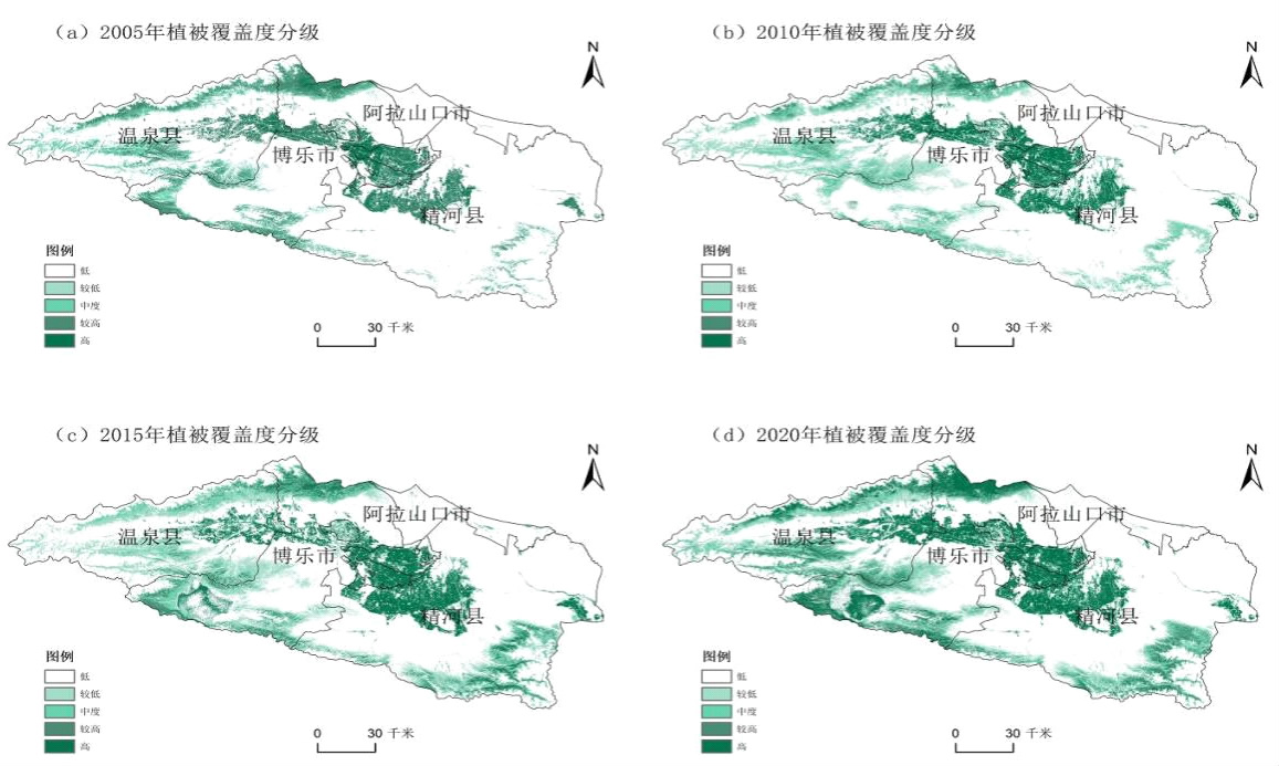
| 植被覆盖度等级 | 2005年 | 2010年 | 2015年 | 2020年 | |||||||
|---|---|---|---|---|---|---|---|---|---|---|---|
| 面积/km2 | 比例/% | 面积/km2 | 比例/% | 面积/km2 | 比例/% | 面积/km2 | 比例/% | ||||
| 低 | 19348.0 | 77.68 | 17477.2 | 70.17 | 14917.2 | 59.89 | 15868.5 | 63.71 | |||
| 较低 | 2683.4 | 10.77 | 2961.7 | 11.89 | 2647.3 | 10.63 | 3236.0 | 12.99 | |||
| 中度 | 1693.5 | 6.8 | 1809.4 | 7.26 | 2060.5 | 8.27 | 2010.7 | 8.07 | |||
| 较高 | 725.8 | 2.91 | 1062.7 | 4.27 | 2067.6 | 8.30 | 1536.8 | 6.17 | |||
| 高 | 456 | 1.83 | 1595.8 | 6.41 | 3214.1 | 12.90 | 2254.7 | 9.05 | |||

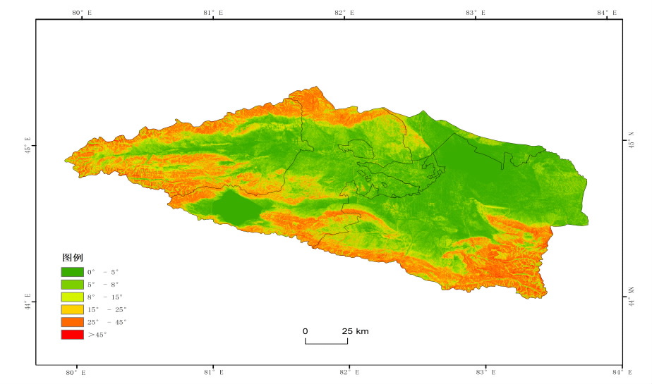
| 坡度范围 | 植被覆盖度均值 | 面积占比/% | |||
|---|---|---|---|---|---|
| 2005年 | 2010年 | 2015年 | 2020年 | ||
| 0°—5° | 0.10 | 0.18 | 0.26 | 0.23 | 38.48 |
| 5°—8° | 0.10 | 0.17 | 0.23 | 0.21 | 15.43 |
| 8°—15° | 0.11 | 0.16 | 0.24 | 0.20 | 16.12 |
| 15°—25° | 0.15 | 0.20 | 0.32 | 0.24 | 12.93 |
| 25°—45° | 0.15 | 0.19 | 0.33 | 0.26 | 16.06 |
| >45° | 0.09 | 0.13 | 0.23 | 0.21 | 0.99 |
| 项目 | 坡度 | GDP | 降水 | 道路 | 人口密度 | 温度 | 水系 | 土地利用 |
|---|---|---|---|---|---|---|---|---|
| q统计量 | 0.0086 | 0.0582 | 0.0579 | 0.1112 | 0.0573 | 0.0575 | 0.0521 | 0.7828 |
| P值 | 0.02 | 0.00 | 0.00 | 0.01 | 0.00 | 0.00 | 0.03 | 0.00 |
| 项目 | 坡度 | GDP | 降水 | 道路 | 人口密度 | 温度 | 水系 | 土地利用 |
|---|---|---|---|---|---|---|---|---|
| q统计量 | 0.0086 | 0.0582 | 0.0579 | 0.1112 | 0.0573 | 0.0575 | 0.0521 | 0.7828 |
| P值 | 0.02 | 0.00 | 0.00 | 0.01 | 0.00 | 0.00 | 0.03 | 0.00 |
| 坡度 | GDP | 降水 | 道路 | 人口密度 | 温度 | 水系 | 土地利用 | |
|---|---|---|---|---|---|---|---|---|
| 坡度 | 0.009 | |||||||
| GDP | 0.082* | 0.057 | ||||||
| 降水 | 0.082* | 0.061 | 0.057 | |||||
| 道路 | 0.171* | 0.174 | 0.174 | 0.111 | ||||
| 人口密度 | 0.082* | 0.061 | 0.061 | 0.174 | 0.057 | |||
| 温度 | 0.082* | 0.061 | 0.061 | 0.174 | 0.061 | 0.057 | ||
| 水系 | 0.109* | 0.216* | 0.216* | 0.263* | 0.216* | 0.216* | 0.052 | |
| 土地利用 | 0.817*+ | 0.806+ | 0.086+ | 0.794+ | 0.086+ | 0.086+ | 0.809+ | 0.783+ |
| [1] |
杨爽, 冯晓明, 陈利顶. 土地利用变化的时空分异特征及驱动机制——以北京市海淀区、延庆县为例[J]. 生态学报, 2009, 29(8):4501-4511.
|
| [2] |
王鹏, 吴炳方, 张磊, 等. 三峡水库建设期秭归县土地利用时空变化特征分析[J]. 农业工程学报, 2010, 26(6):302-309.
|
| [3] |
宋开山, 刘殿伟, 王宗明, 等. 1954年以来三江平原土地利用变化及驱动力[J]. 地理学报, 2008, 63(1):93-104.
|
| [4] |
冯异星, 罗格平, 周德成, 等. 近50a土地利用变化对干旱区典型流域景观格局的影响——以新疆玛纳斯河流域为例[J]. 生态学报, 2010, 30(16):4295-4305.
|
| [5] |
刘纪远, 张增祥, 庄大方, 等. 20世纪90年代中国土地利用变化时空特征及其成因分析[J]. 地理研究, 2003, 22(1):1-12.
|
| [6] |
刘聪颖. 西南山地城市生态基础理论及案例研究——西南山地城市生态景观形态研究[D]. 重庆: 重庆大学, 2012.
|
| [7] |
马明国, 曹宇, 程国栋. 干旱区绿洲廊道景观研究——以金塔绿洲为例[J]. 应用生态学报, 2002, 13(12):1624-1628.
|
| [8] |
卢响军, 周益民, 侯秀玲, 等. 基于土地利用/覆盖的干旱绿洲区植被覆盖度变化——以新疆生产建设兵团第八师为例[J]. 中国生态农业学报(中英文), 2015, 23(2):246-256.
|
| [9] |
张慧. 基于景观安全格局的济南市南部山区生态用地研究[D]. 济南: 山东师范大学, 2012.
|
| [10] |
符静, 秦建新, 张猛, 等. 2001—2013年洞庭湖流域植被覆盖度时空变化特征[J]. 地球信息科学学报, 2016, 18(9):1209-1216.
doi: 10.3724/SP.J.1047.2016.01209 |
| [11] |
王磊, 王杰, 付林, 等. 南充市辖区近15年植被覆盖度变化特征[J]. 生态科学, 2019, 38(1):159-167.
|
| [12] |
李慧, 陈健飞, 余明. 线性光谱混合模型的ASTER影像植被应用分析[J]. 地球信息科学, 2005, 7(1):103-106.
|
| [13] |
吴昌广, 周志翔, 肖文发, 等. 基于MODIS NDVI的三峡库区植被覆盖度动态监测[J]. 林业科学, 2012, 48(1):22-28.
|
| [14] |
牛宝茹, 刘俊蓉, 王政伟. 干旱半干旱地区植被覆盖度遥感信息提取研究[J]. 武汉大学学报(信息科学版), 2005, 30(1):27-30.
|
| [15] |
李向婷, 白洁, 李光录, 等. 新疆荒漠稀疏植被覆盖度信息遥感提取方法比较[J]. 干旱区地理, 2013, 36(3):502-511.
|
| [16] |
张东海, 任志远. 基于MODIS的陕西黄土高原植被覆盖度变化特征及其驱动分析[J]. 生态与农村环境学报, 2013, 29(1):29-35.
|
| [17] |
王智, 师庆三, 王涛, 等. 1982―2006年新疆山地绿洲荒漠系统植被覆盖变化时空特征[J]. 自然资源学报, 2011, 26(4):609-618.
|
| [18] |
潘学平. 呼伦贝尔草原植被覆盖度与地上生物量时空格局研究[D]. 石家庄: 河北师范大学, 2015.
|
| [19] |
张玲, 邓良基. 四川盆地西缘中低山地区耕地时空变化的研究——以雅安市雨城区为例[J]. 四川农业大学学报, 2005, 23(2):218-222.
|
| [20] |
程红芳, 章文波, 陈锋. 植被覆盖度遥感估算方法研究进展[J]. 国土资源遥感, 2008(1):13-18.
|
| [21] |
张世文, 唐南奇. 土地利用/土地覆被变化(LUCC)研究现状与展望[J]. 亚热带农业研究, 2006, 2(3):221-225.
|
| [22] |
王劲峰, 徐成东. 地理探测器:原理与展望[J]. 地理学报, 2017, 72(1):116-134.
doi: 10.11821/dlxb201701010 |
| [23] |
任立清. 艾比湖流域植被时空变化及驱动力分析[J]. 干旱区地理, 2022, 45(2):467-477.
|
| [24] |
高鹏文, 阿里木江·卡斯木, 赵永玉, 等. 1988—2018年哈密绿洲植被覆盖度时空变化及其驱动力[J]. 水土保持通报, 2020, 40(6):273-280.
|
| [1] | 薛文瑞, 杨自辉, 张永, 郭树江, 王强强, 张剑挥. 民勤荒漠绿洲植被覆盖对地下水和降水变化的响应[J]. 中国农学通报, 2022, 38(8): 102-109. |
| [2] | 孙喜军, 邓睿, 吕爽, 高莹, 蔡苗, 缑巧红, 赵娟. 西安市农用地土壤有机质空间变异特征[J]. 中国农学通报, 2022, 38(35): 43-53. |
| [3] | 田雨桐, 韩志伟, 赵然, 田永著, 罗广飞, 杨淼. 西南岩溶农业区典型土地利用对土壤氮素特征的影响[J]. 中国农学通报, 2022, 38(33): 89-96. |
| [4] | 高琳, 胡晋豪, 汪志超, 林昌华, 冯慧敏. 粤北山区县域土地利用对生态服务价值的影响[J]. 中国农学通报, 2022, 38(32): 69-77. |
| [5] | 汪欢欢, 杨琴, 蒲红梅, 何进, 程华, 韩敏, 赵学春, 王志伟, 金宝成. 照片样线法大豆植被覆盖度测量精度分析[J]. 中国农学通报, 2022, 38(32): 111-118. |
| [6] | 韩伟, 徐珊. 松嫩平原土地利用变化特征及生态系统服务价值研究——以哈尔滨市为例[J]. 中国农学通报, 2022, 38(26): 82-90. |
| [7] | 马苏, 崔国屹, 赵玉, 赵莹, 刘雪珍, 张承栋. 植被NPP时空变化特征及驱动因子分析——以延安地区为例[J]. 中国农学通报, 2022, 38(19): 93-98. |
| [8] | 吴松, 刘永志, 杨立宾, 江云兵, 周甜. 森林温室气体排放的研究态势分析[J]. 中国农学通报, 2022, 38(19): 99-108. |
| [9] | 解林晓, 段艺芳, 肖超菲, 李金龙. 山东省土地利用生态-社会-经济系统耦合协调度时空演变及障碍因子分析[J]. 中国农学通报, 2022, 38(12): 61-68. |
| [10] | 卜祥, 张永福, 梁田田, 王建国. 基于MODIS数据2001—2019年NDVI时空变化及驱动力分析——以阿克苏地区为例[J]. 中国农学通报, 2022, 38(11): 75-83. |
| [11] | 张莹, 叶宝鉴, 朱志鹏, 姚雄. 福建省土地利用格局的地形梯度效应分析[J]. 中国农学通报, 2022, 38(11): 96-105. |
| [12] | 鲁韦坤, 逄涛, 余凌翔, 张加云. 市场经济对云南规划烟区耕地资源的影响分析[J]. 中国农学通报, 2021, 37(5): 137-142. |
| [13] | 纪树志. 极旱荒漠区湿地植被动态变化监测——以甘肃敦煌阳关国家级自然保护区为例[J]. 中国农学通报, 2021, 37(26): 105-109. |
| [14] | 田长丰, 牛雄, 杨秋生. 中国农业土地利用的生态智慧及启示[J]. 中国农学通报, 2021, 37(26): 146-152. |
| [15] | 马和平, 屈兴乐, 王建科, 宋小广. 西藏尼洋河中上游流域不同土地利用方式土壤养分含量差异分析[J]. 中国农学通报, 2021, 37(25): 103-108. |
| 阅读次数 | ||||||
|
全文 |
|
|||||
|
摘要 |
|
|||||