欢迎访问《中国农学通报》,
中国农学通报 ›› 2023, Vol. 39 ›› Issue (24): 77-83.doi: 10.11924/j.issn.1000-6850.casb2022-0750
王嘉浩( ), 肖洋(), 张瑞豪, 王艳, 牛羽萱, 贺旭杨
收稿日期:2022-08-29
修回日期:2022-11-02
出版日期:2023-08-25
发布日期:2023-08-23
通讯作者:
肖洋,男,1978年出生,黑龙江哈尔滨人,副教授,博士,主要从事农业水土保持方面的研究。通信地址:150080 黑龙江省哈尔滨市南岗区学府路74号 黑龙江大学184信箱,Tel:0451-86609487,E-mail:作者简介:王嘉浩,男,1998年出生,陕西宝鸡人,硕士,主要从事农业水土保持方面的研究。通信地址:150080 黑龙江省哈尔滨市南岗区学府路74号 黑龙江大学现代农业与生态环境学院,Tel:0451-86609487,E-mail:1103976889@qq.com。
基金资助:
WANG Jiahao(), XIAO Yang(), ZHANG Ruihao, WANG Yan, NIU Yuxuan, HE Xuyang
Received:2022-08-29
Revised:2022-11-02
Online:2023-08-25
Published:2023-08-23
摘要:
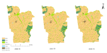
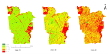
植被覆盖度既是量化植物群落覆盖地表状况的指标参数,也是开展遥感物理模型定量研究的基本参数,植被覆盖度的变化状况反映了地区生态环境变化情况。本研究将克东县作为研究区域,基于2000—2020年GlobeLand30及Landsat遥感数据集,利用遥感影像解译、叠加分析等方法,对植被覆盖度的演化趋势进行研究。结果表明:(1)研究区以耕地为主要土地利用类型,类型从耕地>草地>林地>水域>建设用地>其他土地>特殊用地向着耕地>草地>林地>建设用地>特殊用地>水域>其他土地进行发展;(2)植被覆盖类型从以较低覆盖度为主导向着较高覆盖度推进,整体上呈现从低到高的发展趋势;(3)各土地利用类型中,耕地、草地、水域、建设用地、其他土地的植被覆盖度呈增长态势,林地保持不变,特殊用地呈下降趋势。总体上,克东县2000—2020年植被生长状况良好,植被覆盖类型从低覆盖度向着高覆盖度发展,在保持稳定的基础上,呈发展态势。
王嘉浩, 肖洋, 张瑞豪, 王艳, 牛羽萱, 贺旭杨. 克东县2000—2020年植被覆盖变化分析[J]. 中国农学通报, 2023, 39(24): 77-83.
WANG Jiahao, XIAO Yang, ZHANG Ruihao, WANG Yan, NIU Yuxuan, HE Xuyang. Analysis of Vegetation Coverage Change in Kedong County in 2000-2020[J]. Chinese Agricultural Science Bulletin, 2023, 39(24): 77-83.


| 土地利用类型 | 2000 | 2010 | 2020 | ||||||||
|---|---|---|---|---|---|---|---|---|---|---|---|
| count | 面积/km2 | 占比/% | count | 面积/km2 | 占比/% | count | 面积/km2 | 占比/% | |||
| 耕地 | 1877365 | 1691.35 | 81.18 | 1870887 | 1685.54 | 80.90 | 1865606 | 1680.88 | 80.68 | ||
| 林地 | 149491 | 136.49 | 6.47 | 148152 | 133.38 | 6.41 | 148286 | 133.58 | 6.41 | ||
| 草地 | 193666 | 173.30 | 8.38 | 188737 | 168.71 | 8.16 | 190772 | 170.29 | 8.25 | ||
| 特殊用地 | 158 | 0.14 | 0.01 | 65 | 0.05 | 0.01 | 4226 | 3.78 | 0.18 | ||
| 水域 | 8629 | 7.68 | 0.37 | 9494 | 8.47 | 0.41 | 3423 | 3.02 | 0.15 | ||
| 建设用地 | 82498 | 73.63 | 3.57 | 94540 | 84.50 | 4.09 | 99556 | 89.12 | 4.31 | ||
| 其他土地 | 388 | 0.32 | 0.02 | 372 | 0.30 | 0.02 | 373 | 0.30 | 0.02 | ||
| 植被覆盖度类型 | 2000 | 2010 | 2020 | |||||||||
|---|---|---|---|---|---|---|---|---|---|---|---|---|
| count | 面积/km2 | 占比/% | count | 面积/km2 | 占比/% | count | 面积/km2 | 占比/% | ||||
| 0~0.1 | 低覆盖度 | 20531 | 18.58 | 0.89 | 10050 | 9.09 | 0.44 | 5680 | 5.14 | 0.25 | ||
| 0.1~0.3 | 较低覆盖度 | 1507527 | 1364.42 | 65.51 | 563768 | 509.81 | 24.50 | 82008 | 74.16 | 3.56 | ||
| 0.3~0.5 | 中等覆盖度 | 359074 | 324.99 | 15.60 | 1096423 | 991.49 | 47.65 | 674471 | 609.91 | 29.31 | ||
| 0.5~0.7 | 较高覆盖度 | 169165 | 153.11 | 7.35 | 304516 | 275.37 | 13.23 | 1023744 | 925.75 | 44.49 | ||
| 0.7~1 | 高覆盖度 | 245087 | 221.82 | 10.65 | 326420 | 295.18 | 14.18 | 515325 | 466.00 | 22.39 | ||
| 土地利用类型 | 植被覆盖类型 | 2000 | 2010 | 2020 | ||||||||
|---|---|---|---|---|---|---|---|---|---|---|---|---|
| count | 面积/km2 | 占比/% | count | 面积/km2 | 占比/% | count | 面积/km2 | 占比/% | ||||
| 耕地 | 低覆盖度 | 10300 | 9.27 | 0.55 | 4305 | 3.88 | 0.23 | 2312 | 2.01 | 0.12 | ||
| 较低覆盖度 | 1425779 | 1283.57 | 75.89 | 507895 | 457.72 | 27.16 | 59619 | 51.93 | 3.09 | |||
| 中等覆盖度 | 296238 | 266.69 | 15.77 | 1025919 | 924.59 | 54.85 | 597623 | 520.56 | 30.97 | |||
| 较高覆盖度 | 98997 | 89.12 | 5.27 | 240615 | 216.85 | 12.87 | 963357 | 839.13 | 49.92 | |||
| 高覆盖度 | 47461 | 42.73 | 2.53 | 91534 | 82.49 | 4.89 | 306822 | 267.26 | 15.90 | |||
| 林地 | 低覆盖度 | 38 | 0.03 | 0.03 | 35 | 0.35 | 0.02 | 71 | 0.06 | 0.05 | ||
| 较低覆盖度 | 433 | 0.40 | 0.29 | 297 | 0.27 | 0.20 | 777 | 0.70 | 0.52 | |||
| 中等覆盖度 | 1677 | 1.54 | 1.12 | 1533 | 1.38 | 1.04 | 3555 | 3.21 | 2.40 | |||
| 较高覆盖度 | 6076 | 5.56 | 4.08 | 6625 | 5.97 | 4.48 | 7326 | 6.61 | 4.95 | |||
| 高覆盖度 | 140853 | 128.96 | 94.48 | 139540 | 125.73 | 94.26 | 136385 | 123.00 | 92.08 | |||
| 草地 | 低覆盖度 | 1130 | 1.14 | 0.59 | 806 | 0.73 | 0.43 | 489 | 0.45 | 0.26 | ||
| 较低覆盖度 | 26749 | 27.00 | 13.97 | 9872 | 8.94 | 5.30 | 7059 | 6.44 | 3.78 | |||
| 中等覆盖度 | 45855 | 46.28 | 23.94 | 30553 | 27.67 | 16.40 | 39963 | 36.78 | 21.42 | |||
| 较高覆盖度 | 60521 | 61.08 | 31.60 | 46620 | 42.23 | 25.03 | 51837 | 47.31 | 27.78 | |||
| 高覆盖度 | 57277 | 57.81 | 29.90 | 98412 | 89.14 | 52.83 | 87219 | 79.61 | 46.75 | |||
| 特殊用地 | 低覆盖度 | 1 | 0.00 | 0.69 | 14 | 0.02 | 41.18 | 77 | 0.43 | 11.41 | ||
| 较低覆盖度 | 48 | 0.05 | 33.33 | 15 | 0.02 | 44.12 | 240 | 1.34 | 35.56 | |||
| 中等覆盖度 | 74 | 0.07 | 51.39 | 5 | 0.01 | 14.71 | 232 | 1.30 | 34.37 | |||
| 较高覆盖度 | 16 | 0.02 | 11.11 | 0 | 0.00 | 0.00 | 109 | 0.61 | 16.15 | |||
| 高覆盖度 | 5 | 0.00 | 3.47 | 0 | 0.00 | 0.00 | 17 | 0.10 | 2.52 | |||
| 水域 | 低覆盖度 | 444 | 1.56 | 20.35 | 998 | 2.17 | 25.66 | 125 | 0.29 | 9.75 | ||
| 较低覆盖度 | 997 | 3.51 | 45.69 | 1438 | 3.13 | 36.97 | 242 | 0.57 | 18.88 | |||
| 中等覆盖度 | 585 | 2.06 | 26.81 | 879 | 1.91 | 22.60 | 352 | 0.83 | 27.46 | |||
| 较高覆盖度 | 141 | 0.50 | 6.46 | 422 | 0.92 | 10.85 | 361 | 0.85 | 28.16 | |||
| 高覆盖度 | 15 | 0.05 | 0.69 | 153 | 0.33 | 3.93 | 202 | 0.48 | 15.76 | |||
| 建设用地 | 低覆盖度 | 8248 | 7.78 | 10.56 | 3894 | 3.61 | 4.27 | 3445 | 3.16 | 3.54 | ||
| 较低覆盖度 | 50651 | 47.76 | 64.87 | 41451 | 38.44 | 45.49 | 17547 | 16.08 | 18.05 | |||
| 中等覆盖度 | 15094 | 14.23 | 19.33 | 36413 | 33.77 | 39.96 | 41529 | 38.06 | 42.71 | |||
| 较高覆盖度 | 3577 | 3.37 | 4.58 | 8248 | 7.65 | 9.05 | 26304 | 24.11 | 27.05 | |||
| 高覆盖度 | 516 | 0.49 | 0.66 | 1120 | 1.04 | 1.23 | 8413 | 7.71 | 8.65 | |||
| 其他土地 | 低覆盖度 | 1 | 0.00 | 0.31 | 2 | 0.00 | 0.66 | 6 | 0.01 | 1.79 | ||
| 较低覆盖度 | 43 | 0.04 | 13.31 | 3 | 0.00 | 0.99 | 17 | 0.02 | 5.06 | |||
| 中等覆盖度 | 70 | 0.07 | 21.67 | 25 | 0.02 | 8.22 | 53 | 0.05 | 15.77 | |||
| 较高覆盖度 | 103 | 0.10 | 31.89 | 22 | 0.02 | 7.24 | 53 | 0.05 | 15.77 | |||
| 高覆盖度 | 106 | 0.11 | 32.82 | 252 | 0.25 | 82.89 | 207 | 0.18 | 61.61 | |||


| [1] |
毛盛林, 上官周平. 近20年黄土高原土地利用/植被覆盖变化特征及其成因[J]. 水土保持研究, 2022, 29(5):213-219.
|
| [2] |
阿妮克孜·肉孜, 张岩, 何远梅, 李镇, 杨松. 基于QuickBird影像的黄土高原植被恢复差异[J]. 干旱区研究, 2016, 33(3):554-559.
|
| [3] |
徐焕. 黄土高原植被覆盖时空变化的遥感监测及其驱动力分析[D]. 北京: 中国科学院大学(中国科学院遥感与数字地球研究所), 2017.
|
| [4] |
万红梅, 李霞, 董道瑞. 基于多源遥感数据的荒漠植被覆盖度估测[J]. 应用生态学报, 2012, 23(12):3331-3337.
|
| [5] |
贾坤, 姚云军, 魏香琴, 等. 植被覆盖度遥感估算研究进展[J]. 地球科学进展, 2013, 28(7):774-782.
doi: 10.11867/j.issn.1001-8166.2013.07.0774 |
| [6] |
刘琳, 郑兴明, 姜涛, 等. 无人机遥感植被覆盖度提取方法研究综述[J]. 东北师大学报:自然科学版, 2021, 53(4):151-160.
|
| [7] |
赵春玲, 李志刚, 吕海军, 等. 中德合作宁夏贺兰山封山育林育草项目区植被覆盖度监测[J]. 宁夏农林科技, 2000(S1):6-14.
|
| [8] |
钱娅. 2006-2015年江苏省植被覆盖度的演变趋势与预测研究[D]. 南京: 南京信息工程大学, 2021.
|
| [9] |
王思, 张路路, 林伟彪, 等. 基于MODIS-归一化植被指数的广东省植被覆盖与土地利用变化研究[J]. 生态学报, 2022, 42(6):2149-2163.
|
| [10] |
赫英明, 刘向培, 王汉杰. 基于EVI的中国最近10a植被覆盖变化特征分析[J]. 气象科学, 2017, 37(1):51-59.
|
| [11] |
孙斌, 李增元, 郭中, 等. 高分一号与Landsat TM数据估算稀疏植被信息对比[J]. 遥感信息, 2015, 30(5):48-56.
|
| [12] |
杜英坤, 燕琴, 骆成凤, 等. 石家庄1995—2015年植被覆盖变化监测及预测[J]. 遥感信息, 2016, 31(4):101-107.
|
| [13] |
李国亮. 2000—2012年黑河流域上游植被覆盖变化遥感监测与分析[D]. 兰州: 西北师范大学, 2015.
|
| [14] |
徐焕. 黄土高原植被覆盖时空变化的遥感监测及其驱动力分析[D]. 北京: 中国科学院大学(中国科学院遥感与数字地球研究所), 2017.
|
| [15] |
严登明, 翁白莎, 于志磊, 等. 淮河流域土地利用时空格局动态及其植被覆盖变化分析[J]. 中国农村水利水电, 2016(11):52-57.
|
| [16] |
苏丛鹏. 克东县水土流失现状调查与治理措施[J]. 黑龙江水利科技, 2009, 37(3):199-200.
|
| [17] |
王亭月. 2012—2018年黑龙江省植被覆盖度动态变化分析[J]. 国土与自然资源研究, 2020(4):16-21.
|
| [18] |
方利, 王文杰, 蒋卫国, 等. 2000—2014年黑龙江流域(中国)植被覆盖时空变化及其对气候变化的响应[J]. 地理科学, 2017, 37(11):1745-1754.
doi: 10.13249/j.cnki.sgs.2017.11.017 |
| [19] |
张慧, 邱凯玉, 王宇瑶, 等. 农业主产区土地生态安全格局构建——以克东县为例[J]. 水土保持研究, 2021, 28(6):274-282.
|
| [20] |
张波. 基于RS和GIS的小流域生态环境质量综合评价[D]. 石家庄: 河北师范大学, 2007.
|
| [21] |
李周. 高分辨率遥感影像土地利用信息提取技术研究[D]. 西安: 西安科技大学, 2018.
|
| [22] |
GB/T 21010-2017, 土地利用现状分类[S].
|
| [23] |
高燕, 张延玲, 何小雷. 东北黑土区耕地分布解译的遥感数据源对比[J]. 中国水土保持, 2016(7):61-65.
|
| [24] |
杨春霞, 姚文艺, 肖培青, 等. 植被覆盖结构对坡面产流产沙的影响及调控机制分析[J]. 水利学报, 2019, 50(9):1078-1085.
|
| [25] |
初庆伟, 张洪群, 吴业炜, 等. Landsat-8卫星数据应用探讨[J]. 遥感信息, 2013, 28(4):110-114.
|
| [26] |
张超. 基于“3S”技术的大熊猫潜在栖息地研究[D]. 成都: 成都理工大学, 2016.
|
| [27] |
李苗苗. 植被覆盖度的遥感估算方法研究[D]. 北京: 中国科学院研究生院(遥感应用研究所), 2003.
|
| [28] |
王瑾, 闫庆武, 谭学玲, 等. 内蒙古地区植被覆盖动态及驱动因素分析[J]. 林业资源管理, 2019(4):159-167.
|
| [29] |
王国重, 李中原, 田颖超, 等. 雨强和土地利用类型对豫西南山区产流产沙的影响[J]. 武汉大学学报:工学版, 2017, 50(2):182-186.
|
| [30] |
高倩倩, 陈灿, 刘贺娜, 等. 闽江流域植被覆盖度时空变化及地形分异特征[J]. 林业资源管理, 2022(2):91-99.
|
| [31] |
何利平, 简季. 四川省2009—2020年植被覆盖度时空变化遥感动态监测[J]. 水土保持通报, 2022, 42(2):203-209.
|
| [32] |
薛东剑. RS与GIS在区域地质灾害风险评价中的应用[D]. 成都: 成都理工大学, 2010.
|
| [1] | 管雅芳, 焦阳, 臧传富. 韩江流域土地利用时空变化特征及其生态安全评估[J]. 中国农学通报, 2023, 39(20): 91-99. |
| [2] | 刘兆旭, 刘晶, 郑国宏, 李建刚. 博尔塔拉蒙古自治州土地/植被覆盖变化及驱动力分析[J]. 中国农学通报, 2023, 39(16): 68-76. |
| [3] | 薛文瑞, 杨自辉, 张永, 郭树江, 王强强, 张剑挥. 民勤荒漠绿洲植被覆盖对地下水和降水变化的响应[J]. 中国农学通报, 2022, 38(8): 102-109. |
| [4] | 孙喜军, 邓睿, 吕爽, 高莹, 蔡苗, 缑巧红, 赵娟. 西安市农用地土壤有机质空间变异特征[J]. 中国农学通报, 2022, 38(35): 43-53. |
| [5] | 田雨桐, 韩志伟, 赵然, 田永著, 罗广飞, 杨淼. 西南岩溶农业区典型土地利用对土壤氮素特征的影响[J]. 中国农学通报, 2022, 38(33): 89-96. |
| [6] | 汪欢欢, 杨琴, 蒲红梅, 何进, 程华, 韩敏, 赵学春, 王志伟, 金宝成. 照片样线法大豆植被覆盖度测量精度分析[J]. 中国农学通报, 2022, 38(32): 111-118. |
| [7] | 高琳, 胡晋豪, 汪志超, 林昌华, 冯慧敏. 粤北山区县域土地利用对生态服务价值的影响[J]. 中国农学通报, 2022, 38(32): 69-77. |
| [8] | 韩伟, 徐珊. 松嫩平原土地利用变化特征及生态系统服务价值研究——以哈尔滨市为例[J]. 中国农学通报, 2022, 38(26): 82-90. |
| [9] | 吴松, 刘永志, 杨立宾, 江云兵, 周甜. 森林温室气体排放的研究态势分析[J]. 中国农学通报, 2022, 38(19): 99-108. |
| [10] | 解林晓, 段艺芳, 肖超菲, 李金龙. 山东省土地利用生态-社会-经济系统耦合协调度时空演变及障碍因子分析[J]. 中国农学通报, 2022, 38(12): 61-68. |
| [11] | 张莹, 叶宝鉴, 朱志鹏, 姚雄. 福建省土地利用格局的地形梯度效应分析[J]. 中国农学通报, 2022, 38(11): 96-105. |
| [12] | 鲁韦坤, 逄涛, 余凌翔, 张加云. 市场经济对云南规划烟区耕地资源的影响分析[J]. 中国农学通报, 2021, 37(5): 137-142. |
| [13] | 纪树志. 极旱荒漠区湿地植被动态变化监测——以甘肃敦煌阳关国家级自然保护区为例[J]. 中国农学通报, 2021, 37(26): 105-109. |
| [14] | 田长丰, 牛雄, 杨秋生. 中国农业土地利用的生态智慧及启示[J]. 中国农学通报, 2021, 37(26): 146-152. |
| [15] | 马和平, 屈兴乐, 王建科, 宋小广. 西藏尼洋河中上游流域不同土地利用方式土壤养分含量差异分析[J]. 中国农学通报, 2021, 37(25): 103-108. |
| 阅读次数 | ||||||
|
全文 |
|
|||||
|
摘要 |
|
|||||