欢迎访问《中国农学通报》,

中国农学通报 ›› 2024, Vol. 40 ›› Issue (32): 135-142.doi: 10.11924/j.issn.1000-6850.casb2024-0068

• 资源·环境·生态·土壤·气象 • 上一篇    下一篇

新疆巴州地区小麦干热风时空变化特征及风险区划

霍锦(), 余惠乔, 张仕明(), 黄玖君   

  1. 巴州气象局,新疆库尔勒 841000
  • 收稿日期:2024-01-15 修回日期:2024-06-24 出版日期:2024-11-15 发布日期:2024-11-12
  • 通讯作者:
    张仕明,男,1975年出生,高级工程师,大专,主要从事农业气象服务及应用气象等方面的研究。通信地址:841000 新疆库尔勒市人民西路102号,Tel:0996-2161992,E-mail:
  • 作者简介:

    霍锦,女,1982年出生,高级工程师,本科,主要从事农业气象服务及气象灾害防御等方面的研究。通信地址:841000 新疆库尔勒市人民西路102号,Tel:0996-2161992,E-mail:

  • 基金资助:
    新疆巴州气象局气象科研基金项目“基于GIS的巴州小麦干热风风险区划”(202302); 新疆气象局面上基金项目“新疆小麦干热风精细化监测与预测技术研究”(MS202215)

Spatiotemporal Change Characteristics and Risk Zoning of Wheat Dry Hot Wind in Bazhou of Xinjiang

HUO Jin(), YU Huiqiao, ZHANG Shiming(), HUANG Jiujun   

  1. Bazhou Meteorological Bureau, Korla, Xinjiang 841000
  • Received:2024-01-15 Revised:2024-06-24 Published:2024-11-15 Online:2024-11-12

摘要:

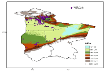
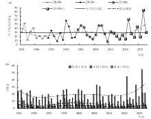
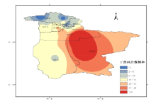
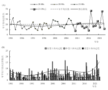
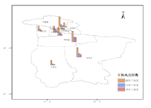
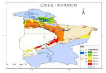
掌握巴州地区小麦干热风灾害的发生发展规律,有针对性地采取防御措施,对于保障当地粮食安全具有重要意义。选取若羌县、轮台县和焉耆县作为代表地,根据不同地区干热风对小麦的影响,参照小麦干热风气象行业标准,利用1981—2023年5—6月巴州地区9个国家级气象站及农区114区域自动站逐日气象观测数据、农业气象观测站小麦发育期数据及地理基础信息等资料,结合ArcGIS10.8作图,分析巴州地区小麦干热风日数和过程的时空变化特征,并进行风险区划与评估。结果表明,近43 a来巴州地区干热风整体呈波动上升趋势,趋势倾向率分别为2.2 d/10a、1.2次/10a。20世纪80年代减少较为明显,20世纪90年代、21世纪10年代呈增多趋势,2011年后明显增多,具有时间阶段性特征,其中2017、2022年为干热风高发年份。从3种不同等级的干热风占比来看,轻型>中型>重型。研究发现,巴州地区小麦干热风高风险区主要分布在塔里木盆地南缘且末、若羌沿车尔臣河以南小麦种植区域,塔里木盆地东南部的若羌、铁干里克一带以及尉犁县沿塔里木河北部的部分地区,低风险区主要分布在焉耆盆地平原农区大部,库尔勒东部、轮台县西部等地,其余区域为较重及中度风险区。根据不同风险区,可因地制宜采取不同的灾害防御措施。

关键词: 小麦, 干热风, 风险区划, 巴州地区, 气象灾害, 气候变化

Abstract:

It is of great significance to grasp the occurrence and development law of wheat dry hot wind disaster and take targeted defensive measures to ensure food security. According to the meteorological industry standard of wheat dry-hot wind, using the daily meteorological observation data of 9 national meteorological stations and 114 regional automatic stations in agricultural areas in Bazhou from May to June from 1981 to 2023, the data of wheat development period and geographical basic information of agricultural meteorological observation stations, combined with ArcGIS10.8 technical mapping, the spatial and temporal variation characteristics of wheat dry-hot wind days and processes in Bazhou were analyzed, and the risk zoning and evaluation were carried out. The results showed that the number of dry hot wind days and weather process showed a trend of decreasing first and then increasing slowly, and then increasing obviously after decreasing slowly. The trend tendency rate was 2.2 d/10a and 1.2 meta/10 a, respectively in recent 43 years. In the 1980s, the decrease was more obvious, in the 1990s and 2010s, it showed an increasing trend, and after 2011, it increased significantly, which had the characteristics of time stages, and 2017 and 2022 were the years of high dry hot wind. From the proportion of three different degrees of dry-hot wind, the number of days and processes of light dry-hot wind are the most, and the trend of light process is significant; the number and process of medium and heavy dry-hot wind days did not change significantly. The number of dry hot wind days and the number of dry hot wind weather processes are similar in spatial distribution, that is, the desert oasis area in the southeast margin of the Taklimakan Desert is frequent and high occurrence area, the Bosten Lake waters and Yanqi Basin are less occurrence area, and other areas are secondary occurrence area, showing the spatial distribution characteristics of ‘more in the southeast and less in the northeast’ with obvious regionalism. The risk zoning results are divided into four levels of dry hot wind risk areas: heavy, heavier, moderate and mild (no), which can provide reference for disaster prevention in different risk planting areas.

Key words: wheat, dry hot wind, risk zoning, Bazhou Region, meteorological disaster, climate change