欢迎访问《中国农学通报》,
中国农学通报 ›› 2025, Vol. 41 ›› Issue (23): 64-73.doi: 10.11924/j.issn.1000-6850.casb2024-0610
杨洋1( ), 柯莉萍1(), 朱君2, 胡妍妍3, 衮毅3
收稿日期:2024-09-27
修回日期:2025-06-24
出版日期:2025-08-19
发布日期:2025-08-19
通讯作者:
作者简介:杨洋,女,1995年出生,工程师,贵州金沙人,本科,主要研究方向:气象灾害防御。通信地址:551700 贵州省毕节市七星关区开行路171号 毕节市气象局,Tel:0857-8303926,E-mail:1035007816@qq.com。
基金资助:
YANG Yang1(), KE Liping1(), ZHU Jun2, HU Yanyan3, GUN Yi3
Received:2024-09-27
Revised:2025-06-24
Published:2025-08-19
Online:2025-08-19
摘要:
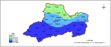
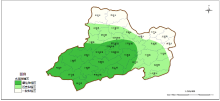
本研究旨在揭示织金县复杂山地地形下水稻种植的农业气象条件,并进行气候适宜性区划。通过数理统计法分析水稻气象产量与气象要素的相关性,识别出影响水稻生长发育的关键气象因子,采用多元线性回归方法构建了适用于织金县的水稻气象产量预报模型,并验证了其预报精度。同时,结合气象和灾害资料,以及灾害指标体系,运用GIS空间分析技术进行气候适宜性区划,绘制了织金县水稻种植气候适宜性区划图。结果表明,5月下旬的平均气温和日照时数,6月下旬的降水量,7月中旬的降水量和日照时数,8月上旬的平均气温和降水量,以及9月上旬的降水量,是影响织金县水稻生长发育的显著气象因子。构建的预报模型验证结果显示,平均预报准确率高于90%,表明该模型具有较高的可信度和区域适用性。气候适宜性区划图显示,织金县中部偏南偏西的乡镇最适宜种植水稻,而北部及东部乡镇的适宜性较差。本研究所建预报模型对织金县水稻产量具有较好的预测能力,生成的气候适宜性区划图清晰揭示了区域差异,可为优化当地水稻种植布局、规避气象灾害风险、提升单产水平提供直观的决策依据。
杨洋, 柯莉萍, 朱君, 胡妍妍, 衮毅. 织金县水稻气象产量动态预报模型及适宜性区划研究[J]. 中国农学通报, 2025, 41(23): 64-73.
YANG Yang, KE Liping, ZHU Jun, HU Yanyan, GUN Yi. Research on Dynamic Forecasting Model and Suitability Zoning of Rice Meteorological Yield in Zhijin County[J]. Chinese Agricultural Science Bulletin, 2025, 41(23): 64-73.
| 预报时间 | a0 | b1 | b2 | b3 | b4 | b5 | b6 | b7 | b8 |
|---|---|---|---|---|---|---|---|---|---|
| 6月1日 | -187.675 | 5.812 | 0.627 | - | - | - | - | - | - |
| 7月1日 | -179.102 | 7.114 | 0.423 | -0.373 | - | - | - | - | - |
| 7月21日 | -168.452 | 9.245 | 0.314 | -0.382 | 0.445 | 0.533 | - | - | - |
| 8月11日 | 422.541 | 0.432 | 0.431 | -0.328 | 0.438 | 0.524 | -20.057 | -0.214 | - |
| 9月11日 | 443.415 | 0.688 | 0.782 | -1.903 | 0.412 | 0.515 | -20.004 | -0.086 | -0.48 |
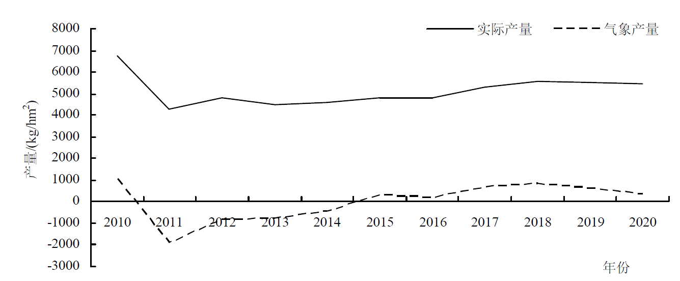
| 年份 | 2010 | 2011 | 2012 | 2013 | 2014 | 2015 | 2016 | 2017 | 2018 | 2019 | 2020 |
|---|---|---|---|---|---|---|---|---|---|---|---|
| 实际产量 | 6750 | 4253 | 4822 | 4510 | 4600 | 4812 | 4825 | 4982 | 5600 | 5502 | 5483 |
| 趋势产量 | 5714 | 6181 | 5275 | 5275 | 6793 | 4528 | 4644 | 4641 | 4747 | 4873 | 5137 |
| 气象产量 | 1036 | -1928 | -453 | -765 | -442 | 284 | 181 | 688 | 853 | 629 | 346 |
| 日期 | 6月1日 | 7月1日 | 7月21日 | 8月11日 | 9月11日 |
|---|---|---|---|---|---|
| 准确率高于95%的比例 | 53% | 54% | 60% | 62% | 54% |
| 准确率90%~95%的比例 | 38% | 36% | 34% | 31% | 39% |
| 准确率低于90%的比例 | 9% | 10% | 6% | 7% | 7% |
| 日期 | 6月1日 | 7月1日 | 7月21日 | 8月11日 | 9月11日 |
|---|---|---|---|---|---|
| 准确率高于95%的比例 | 53% | 54% | 60% | 62% | 54% |
| 准确率90%~95%的比例 | 38% | 36% | 34% | 31% | 39% |
| 准确率低于90%的比例 | 9% | 10% | 6% | 7% | 7% |
| 日期 | 6月1日 | 7月1日 | 7月21日 | 8月11日 | 9月11日 | |
|---|---|---|---|---|---|---|
| 2018年 | 实际产量/(g/m2) | - | - | - | - | 560.0 |
| 预报产量/(g/m2) | 532.2 | 543.1 | 537.8 | 548.8 | 521.3 | |
| 准确率/% | 95 | 97 | 96 | 98 | 93 | |
| 2019年 | 实际产量/(g/m2) | - | - | - | - | 550.2 |
| 预报产量/(g/m2) | 539.4 | 506.3 | 512.3 | 523.4 | 540.4 | |
| 准确率/% | 98 | 92 | 93 | 95 | 98 | |
| 2020年 | 实际产量/(g/m2) | - | - | - | - | 548.3 |
| 预报产量/(g/m2) | 526.8 | 499.8 | 521.4 | 532.5 | 516.2 | |
| 准确率/% | 96 | 91 | 95 | 97 | 94 | |
| 关键期影响因子 | 5月下旬平均 气温/℃ | 5月下旬日照时数/h | 6月下旬降水量/mm | 7月中旬降水量/mm | 7月中旬 日照时数/h | 8月上旬平均 气温/℃ | 8月上旬降水量/mm | 9月上旬降水量/mm |
|---|---|---|---|---|---|---|---|---|
| 适宜性指标 | 18~25 | 38~46 | 107~128 | 150~168 | 41~52 | 20~27℃ | 142~185 | 64~86 |
| 关键期影响因子 | 5月下旬平均 气温/℃ | 5月下旬日照时数/h | 6月下旬降水量/mm | 7月中旬降水量/mm | 7月中旬 日照时数/h | 8月上旬平均 气温/℃ | 8月上旬降水量/mm | 9月上旬降水量/mm |
|---|---|---|---|---|---|---|---|---|
| 适宜性指标 | 18~25 | 38~46 | 107~128 | 150~168 | 41~52 | 20~27℃ | 142~185 | 64~86 |


| 种植区类型 | 5月下旬平均 气温/℃ | 5月下旬日照 时数/h | 6月下旬 降水量/mm | 7月中旬 降水量/mm | 7月中旬日照 时数/h | 8月上旬平均 气温/℃ | 8月上旬降水量/mm | 9月上旬降水量/mm |
|---|---|---|---|---|---|---|---|---|
| 最佳种植区 | 22~25 | 43~46 | 118~128 | 158~168 | 46~52 | 24~27 | 170~185 | 79~86 |
| 适宜种植区 | 18~21.9 | 38~42.9 | 107~117.9 | 150~157.9 | 41~45.9 | 20~23.9 | 142~166.9 | 64~78.9 |
| 一般种植区 | <18 | <38 | <107 | <150 | <41 | <20 | <142 | <64 |

| 种植区类型 | 推荐主导品种类型 | 适宜播期范围 | 重点防范灾害 | 针对性应对措施 |
|---|---|---|---|---|
| 最佳种植区 | 优质高产型(如‘宜香优2115’、‘泰优808’) | 3月下旬—4月上旬 | 偶发倒春寒、 局地暴雨 | 覆膜育苗抗低温;稻田周边开挖排水沟 (深度≥30 cm);扬花期遇雨人工辅助授粉 |
| 适宜种植区 | 中早熟耐寒型(如‘黔两优58’、‘金珍优早’) | 4月中旬—4月25日 | 倒春寒、阶段性 高温干旱 | 推迟播种避低温;蓄水塘坝建设、节水灌溉; 高温时段(>35℃)午后田间循环水降温 |
| 一般种植区 | 特早熟抗逆型 (如‘安粳优1号’、 ‘滇禾优615’) | 4月25日—5月5日 | 倒春寒、暴雨洪涝、 积温不足 | 温室集中育苗、移栽;梯田修筑石坎防洪; 覆盖保温材料延长生长期 |
| [1] |
张静, 张朝, 张亮亮, 等. 基于作物模型与机器学习的水稻障碍型冷害脆弱性研究[J]. 中国农业气象, 2024, 45(9):1053-1066.
|
| [2] |
王秀珍, 张亚杰, 钟文婷, 等. 基于30m网格的海口市暴雨灾害风险评估与区划[J]. 热带农业科学, 2025, 45(5):104-113.
|
| [3] |
吴新娟, 杨思慧, 陈林, 等. 气象因子对水稻灌浆速率及千粒重的影响分析[J]. 安徽农学通报, 2024, 30(16):22-25.
doi: 10.16377/j.cnki.issn1007-7731.2024.16.005 |
| [4] |
陈东东, 栗晓玮, 张璐阳, 等. 西南地区水稻高温热害时空特征及危险性[J]. 中国农业气象, 2024, 45(8):860-871.
|
| [5] |
王芬, 亢强, 李辉, 等. 成都市两系杂交水稻制种气候适宜性区划[J]. 中国农学通报, 2019, 35(1):95-103.
doi: 10.11924/j.issn.1000-6850.casb17090115 |
| [6] |
秦鹏程, 万素琴, 邓环, 等. 湖北省水稻种植布局精细化气候区划[J]. 湖北农业科学, 2016, 55(16):4150-4153.
|
| [7] |
汪进欣, 马力文, 南学军, 等. 基于GIS的宁夏裸燕麦NLY17-05种植气候适宜性精细化区划[J]. 江苏农业科学, 2021, 49(8):102-107.
|
| [8] |
李丽纯, 陈福梓, 王加义, 等. 基于GIS的台湾青枣在福建引扩种的气候适宜性区划[N]. 中国生态农业学报, 2017, 25(1):47-54.
|
| [9] |
雷蕾, 袁媛, 胡晓黎, 等. 商洛市烤烟生长期内主要气象灾害区划及建议[J]. 陕西农业科学, 2019, 65(3):88-90.
|
| [10] |
阚雨萌, 崔修来, 田伟忠, 等. 大石桥市富硒水稻生育期气候特征研究[J]. 现代农业科技, 2024(15):106-108,119.
|
| [11] |
王德燕, 张辉, 等. 天长市气候资源分析与水稻生长期气候区划[J]. 现代农业科技, 2020(17):185-187.
|
| [12] |
任义方, 高苹, 等. 水稻高温热害气象风险区划和评估[N]. 自然灾害学报, 2017, 26(5):62-70.
|
| [13] |
刘洪英, 鲜铁军, 李睿, 等. 基于气象因子的水稻产量预报模型[J]. 陕西气象, 2020(5):45-47.
|
| [14] |
霍军军, 高泰来, 李佳迪, 等. 湖北省极端干湿事件时空变化规律及对水稻长势的影响[J]. 长江科学院院报, 2024(8):63-72.
doi: 10.11988/ckyyb.20230441 |
| [15] |
杨波. 基于气象环境条件和LSSVM的水稻病虫害预测研究[J]. 农业与技术, 2024(9):177-180.
|
| [16] |
梁泽, 曹姗姗, 孔繁涛, 等. 基于CNN-BiLSTM和残差注意力的县域水稻产量预测模型[J]. 湖北农业科学, 2024(8):109-115.
|
| [17] |
张文龙, 时红, 才硕, 等. 水稻干旱时空演变规律及其补偿效应研究进展[J]. 江苏农业科学, 2024(12):8-17.
|
| [18] |
韩静静, 王浩源, 赵吉, 等. 气候变化对我国主产区水稻产量的影响及其机制分析[J]. 南方农业, 2024(15):232-241.
|
| [19] |
张萧楠, 沈彦军, 李红军, 等. 基于METRIC模型的巴基斯坦农业区蒸散量估算[J]. 中国生态农业学报(中英文), 2024, 32(11):1927-1939.
|
| [20] |
席闻阳, 何建军, 王智麟, 等. 基于多层感知机模型的长三角水稻种植区净生态系统碳通量模拟[J]. 高原气象, 2025, 44(1):191-200.
doi: 10.7522/j.issn.1000-0534.2024.00056 |
| [21] |
胡丽琴, 肖正午, 方升亮, 等. 种植季节对高直链淀粉水稻品种淀粉消化特性的影响[J]. 作物学报, 2024(9):2347-2357.
doi: 10.3724/SP.J.1006.2024.42006 |
| [22] |
刘博, 徐涛, 徐强强, 等. 基于叶绿素荧光遥感的江西省稻田总初级生产力估算及其气象驱动因素研究[J]. 农业机械学报, 2024(8):391-400.
|
| [23] |
周浩, 胡凌, 陈藜藜, 等. 衡邵干旱走廊耕地种植结构水分供需评估及其优化[J]. 资源科学, 2024(5):1032-1044.
doi: 10.18402/resci.2024.05.14 |
| [24] |
徐敏, 徐经纬, 徐萌, 等. 水稻高温热害强度时空变化特征与预报模型构建[J]. 农业工程学报, 2024(10):97-106.
|
| [25] |
袁荣. 气候变化下黑龙江省水稻产量与需水量研究[D]. 哈尔滨: 黑龙江大学, 2024.
|
| [26] |
李世刚, 王东仙, 刘可群, 等. 基于灾害风险理论的湖北水稻高温热害风险分析及区划[J]. 气象科技, 2024(2):288-296.
|
| [27] |
董磊明, 张洁新, 刘倩. 基于关键气象因子的曹妃甸区水稻产量动态预报模型技术研究[J]. 黑龙江粮食, 2023(3):48-50.
|
| [1] | 李云溪, 查养良, 陈木兰, 缑耀武, 刘泉. 咸阳阳光玫瑰葡萄种植气候条件分析及适宜性区划[J]. 中国农学通报, 2025, 41(5): 77-83. |
| [2] | 孟庆霞, 白宇轩, 张旭, 金瑞萌, 王文婧. 基于GIS技术内蒙古自治区科右中旗水稻种植气候区划研究[J]. 中国农学通报, 2025, 41(18): 138-142. |
| [3] | 王亚婷, 吴志岐, 张连花, 王鲜丽. 气候变化背景下宁夏马铃薯气候适宜性分析[J]. 中国农学通报, 2025, 41(18): 150-157. |
| [4] | 努尔帕提曼·买买提热依木, 古丽米热·托乎提. 喀什石榴越冬冻害气象指标分析[J]. 中国农学通报, 2025, 41(15): 102-109. |
| [5] | 陈芳, 左晋, 刘宇鹏, 杨世琼, 李慧璇, 刘轩铭, 古书鸿. 贵州铁皮石斛生长气象条件分析与气候品质认证——以安龙为例[J]. 中国农学通报, 2025, 41(1): 112-118. |
| [6] | 许金萍, 蒋晓梅, 胡波, 胡越, 李云, 程仡锴. 基于GIS的安吉县茶树栽培农业气候区划研究[J]. 中国农学通报, 2025, 41(1): 119-125. |
| [7] | 侯梦媛. 基于关键气象因子的山东省棉花产量预报[J]. 中国农学通报, 2024, 40(9): 37-41. |
| [8] | 张小瑞, 闵庆文, 谭凯炎. 潮州凤凰单丛生长气候适宜性分析与品质气候评价[J]. 中国农学通报, 2024, 40(4): 111-117. |
| [9] | 普布多吉, 罗珍, 扎西拉姆, 周刊社, 张东东. 气候变化背景下西藏隆子县黑青稞气候适宜性分析[J]. 中国农学通报, 2024, 40(29): 96-102. |
| [10] | 尹佳琪, 张梅, 罗箭宇, 陈玉光, 杨欣虹, 董雨鑫. 像元尺度上薏米植被指数与气象因子的关系研究[J]. 中国农学通报, 2024, 40(26): 66-72. |
| [11] | 刘璐, 刘静, 任永建, 成丹. 中式雪茄烟生育期气候影响因子分析——以湖北来凤为例[J]. 中国农学通报, 2024, 40(26): 73-79. |
| [12] | 王甜, 杨联安, 张凯然, 陈韩玲, 徐蔚薰, 尚小清. 基于AHP-EWM-TOPSIS的秦岭北麓西安段冰酒葡萄生态适宜性评价[J]. 中国农学通报, 2024, 40(20): 115-121. |
| [13] | 刘娟霞, 任迎萍, 吴海英. 盐池县黄花菜始花期与气象因子的相关分析及预报模型[J]. 中国农学通报, 2024, 40(11): 92-96. |
| [14] | 陈芳, 刘宇鹏, 曾晓珊, 于飞, 胡家敏. 移栽期对辣椒产量、光合特性及气象因子的响应[J]. 中国农学通报, 2024, 40(10): 109-119. |
| [15] | 韩小英, 张蕾, 杨三维, 芦艳珍, 李文婷. 基于GIS的山西高粱种植气候适宜性精细区划[J]. 中国农学通报, 2023, 39(9): 92-99. |
| 阅读次数 | ||||||
|
全文 |
|
|||||
|
摘要 |
|
|||||