欢迎访问《中国农学通报》,
中国农学通报 ›› 2023, Vol. 39 ›› Issue (30): 94-100.doi: 10.11924/j.issn.1000-6850.casb2022-0880
徐永清( ), 刘赫男(), 刘春生, 张洪玲, 蒋慧亮
收稿日期:2022-10-17
修回日期:2023-01-25
出版日期:2023-10-25
发布日期:2023-10-19
通讯作者:
刘赫男,女,1983年出生,黑龙江双鸭山人,高级工程师,硕士,主要从事应用气候研究。通信地址:150030 黑龙江哈尔滨香坊区电碳路71号 黑龙江省气候中心,Tel:0451-55105880,E-mail:104547296@qq.com。
作者简介:徐永清,男,1975年出生,黑龙江甘南人,高级工程师,硕士,主要从事应用气候研究。通信地址:150030 黑龙江哈尔滨香坊区电碳路71号 黑龙江省气候中心,Tel:0451-55105880,E-mail:xtong05@163.com。
基金资助:
XU Yongqing(), LIU Henan(), LIU Chunsheng, ZHANG Hongling, JIANG Huiliang
Received:2022-10-17
Revised:2023-01-25
Published-:2023-10-25
Online:2023-10-19
摘要:
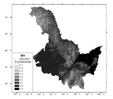
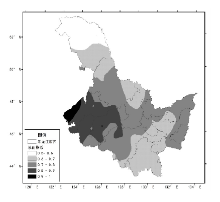
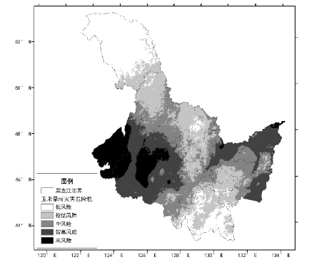
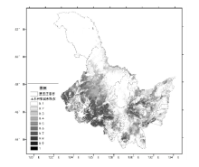
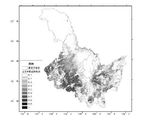
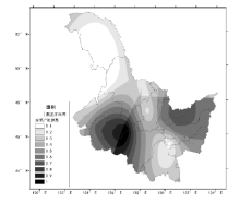
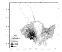
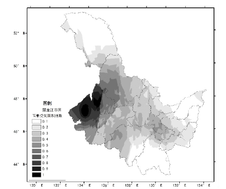
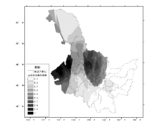
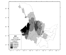
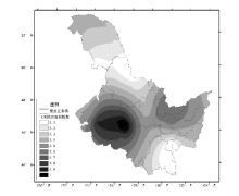
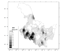
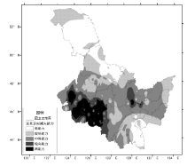
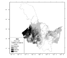
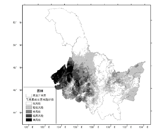
本文采用GIS空间分析技术,以致灾危险性、承灾体暴露性、脆弱性和防灾减灾能力评估为理论基础,进行黑龙江省玉米暴雨洪涝风险评估研究。玉米暴雨危险性评估指标包括孕灾环境影响和暴雨洪涝指数;玉米暴露性评估指标包括玉米单位面积产量和玉米耕种密度;玉米脆弱性评估指标包括受灾玉米面积占比和玉米直接经济损失占比;玉米防灾减灾能力包括除涝面积和人均GDP。评估过程中针对各因子量纲不同,采用均一化方法进行了处理。权重采用层次分析法和专家打分法确定。结果表明:黑龙江省暴雨洪涝高风险区分布在松嫩平原的西部和东部,大兴安岭北部和张广才岭南部地区为低风险区;暴露性较高区域主要集中在松嫩平原的西部,低易损区主要分布在大、兴安岭和张广才岭西部地区;松嫩平原西部为高敏感区,大兴安岭、张广才岭和三江平原地区为低敏感区;松嫩平原南部,具有高或较高的防灾减灾能力,大、兴安岭和张广才岭地区防灾减灾能力较低;黑龙江省玉米暴雨灾害高风险区主要分布在松嫩平原的西部和西北部地区,较高风险区主要分布在松嫩平原北部和东部,大、兴安岭和张广才岭地区为低风险区,较低风险区主要集中在松嫩平原与小兴安岭过度地区和三江平原。
徐永清, 刘赫男, 刘春生, 张洪玲, 蒋慧亮. 黑龙江省玉米暴雨洪涝灾害风险评估研究[J]. 中国农学通报, 2023, 39(30): 94-100.
XU Yongqing, LIU Henan, LIU Chunsheng, ZHANG Hongling, JIANG Huiliang. Study on Risk Assessment of Maize Rainstorm and Flood Disaster in Heilongjiang Province[J]. Chinese Agricultural Science Bulletin, 2023, 39(30): 94-100.

| 一级指标 | 一级指标权重 | 三级指标 | 三级指标权重 |
|---|---|---|---|
| 玉米致灾危险性 指数H | 0.35 | 1 h最大降雨量 | 0.060 |
| 日最大降雨量 | 0.088 | ||
| 过程累计降雨量 | 0.046 | ||
| 暴雨持续日数 | 0.028 | ||
| 地形系数 | 0.077 | ||
| 水系系数 | 0.053 | ||
| 玉米暴露性 指数E | 0.22 | 单位面积产量 | 0.079 |
| 玉米耕种密度 | 0.141 | ||
| 玉米脆弱性 指数V | 0.26 | 经济损失占比 | 0.114 |
| 受灾面积占比 | 0.146 | ||
| 玉米防灾减灾 能力R | 0.17 | 除涝面积 | 0.105 |
| 人均GDP | 0.065 |


| [1] |
张养才, 河维勋, 李世奎. 中国农业气象灾害概论[M]. 北京: 气象出版社, 1991:272-282.
|
| [2] |
杜鹏, 李世奎. 中国农业气象风险评估模型及应用[J]. 气象学报, 1997, 55(1):95-102.
|
| [3] |
陈晓艺, 马哓群, 孙秀邦. 安徽省冬小麦发育期农业干旱发生风险分析[J]. 中国农业气象, 2008, 29(4):472-476.
|
| [4] |
杜尧东, 毛慧勤, 刘锦銮. 华南地区寒害概率分布模型研究[J]. 自然灾害学报, 2003, 12(2):103-107.
|
| [5] |
胡雪琼, 吉文娟, 张茂松, 等. 云南省冬小麦干旱灾损风险区划[J]. 大气科学学报, 2011, 34(3):356-362.
|
| [6] |
王春乙, 王石立, 霍治国, 等. 近10年来中国主要农业气象灾害监测预警与评估技术研究进展[J]. 气象学报, 2005, 63(5):659-671.
|
| [7] |
李娜, 霍治国, 贺楠, 等. 华南地区香蕉、荔枝寒害的气候风险区划[J]. 应用生态学报, 2010, 21(5):1244-1251.
|
| [8] |
刘荣花, 朱自玺, 方文松, 等. 华北平原冬小麦干旱灾损风险区划[J]. 生态学杂志, 2006, 25(9):1068-1072.
|
| [9] |
庞西磊, 黄崇福, 艾福利, 等. 基于信息扩散理论的东北三省农业洪灾风险评估[J]. 中国农学通报, 2012, 28(8):271-275.
|
| [10] |
刘玉英, 石大明, 胡铁鑫, 等. 吉林省农业气象干旱灾害的风险分析及区划[J]. 生态学杂志, 2013, 32(6):1518-1524.
|
| [11] |
任义方, 赵艳霞, 王春乙, 等. 河南省冬小麦干旱保险风险评估与区划[J]. 应用气象学报, 2011, 22(5):537-548.
|
| [12] |
盛绍学, 石磊, 张玉龙, 等. 江淮地区冬小麦渍害指标与风险评估模型研究[J]. 中国农学通报, 2009, 25(19):263-268.
|
| [13] |
王春乙, 张继权, 霍治国, 等. 农业气象灾害风险评估研究进展及展望[J]. 气象学报, 2015, 73(1):1-19.
|
| [14] |
杨舒畅, 申双和. 水稻高温热害及其风险评估的研究进展[J]. 农学学报, 2016, 6(2):122-125.
doi: 10.11923/j.issn.2095-4050.cjas15080004 |
| [15] |
刘佳, 卿清涛, 陈超, 等. 基于热害累计指数的四川单季稻高温热害综合风险评价[J]. 中国生态农业学报(中英文), 2019, 27(9):1440-1452.
|
| [16] |
王祥, 淮建军. 基于三级分层框架的农业气象灾害多风险评估[J]. 自然资源学报, 2020, 35(6):1460-1471.
doi: 10.31497/zrzyxb.20200617 |
| [17] |
United Nations Development Programme. Reducing disaster risk: a challenge for development[J]. John S Swift Co.,USA, 2004:2-4.
|
| [18] |
|
| [19] |
张继权, 冈田宪夫, 多多纳裕一. 综合自然灾害风险管理—全面整合的模式与中国的战略选择[J]. 自然灾害学报, 2006, 15(1):29-37.
|
| [20] |
张继权, 李宁. 主要气象灾害风险评价与管理的数量化方法及其应用[M]. 北京: 北京师范大学出版社, 2013:32-34
|
| [21] |
国家统计局. 中国统计年鉴(2021)[M]. 北京: 中国统计出版社, 2021:235-413.
|
| [22] |
李帅, 陈丽, 王晾晾, 等. 1980年以来黑龙江省玉米低温冷害风险变化研究[J]. 灾害学, 2013, 8(4):100-103.
|
| [23] |
李帅, 王晾晾, 陈莉, 等. 黑龙江省玉米低温冷害风险综合评估模型研究[J]. 自然灾害学报, 2013, 28(4):635-645.
|
| [24] |
杨若子, 周广胜. 东北三省玉米主要农业气象灾害综合危险性评估[J]. 气象学报, 2015, 73(6):1141-1153.
|
| [25] |
王春乙, 蔡菁菁, 张继权, 等. 基于自然灾害风险理论的东北地区玉米干旱、冷害风险评价[J]. 农业工程学报, 2015, 31(6):238-245.
|
| [26] |
高晓容, 王春乙, 张继权, 等. 东北地区玉米主要气象灾害风险评价模型研究[J]. 中国农业科学, 2014, 47(21):4257-4268.
doi: 10.3864/j.issn.0578-1752.2014.21.011 |
| [27] |
黑龙江省统计局. 黑龙江统计年鉴(2021)[M]. 北京: 中国统计出版社, 2021:67-324.
|
| [28] |
章国材. 自然灾害风险评估与区划原理和方法[M]. 北京: 气象出版社, 2013:180-187.
|
| [29] |
徐永清, 陈莉, 刘艳华, 等. 基于不同空间尺度资料的自然灾害风险评估对比分析-以暴雨洪涝灾害为例[J]. 灾害学, 2022, 37(3):61-68.
|
| [1] | 杨苔, 于慧颖, 卢立明, 付海燕, 李国良, 代文龙, 刘春光, 杨峰山, 马玉堃. 促生潜力玉米种子内生细菌分离鉴定及发酵条件优化[J]. 中国农学通报, 2023, 39(9): 16-23. |
| [2] | 钱双宏, 蔡世昆, 朱汉勇, 王绍斌, 李正润, 王应梅, 李绍云. 不同玉米品种(系)在云南省不同生态区丰产、稳产及适应性分析[J]. 中国农学通报, 2023, 39(9): 7-15. |
| [3] | 韩小英, 张蕾, 杨三维, 芦艳珍, 李文婷. 基于GIS的山西高粱种植气候适宜性精细区划[J]. 中国农学通报, 2023, 39(9): 92-99. |
| [4] | 孙梅婷, 李良涛, 王倩, 张晓华, 赵艳丽. 青崖寨国家级自然保护区森林资源及重点保护野生植物空间格局分析[J]. 中国农学通报, 2023, 39(8): 27-36. |
| [5] | 张可心, 鱼潇, 张谋草. 播期对陇东春玉米生长发育进程及产量的影响[J]. 中国农学通报, 2023, 39(6): 6-12. |
| [6] | 杨海峰, 洪德峰, 马俊峰, 王群, 卫晓轶. DTOPSIS法在分析不同基因型玉米间混作效应中的应用[J]. 中国农学通报, 2023, 39(6): 13-17. |
| [7] | 于冲, 张凤云, 黄浩, 路运才. 玉米F2群体轴部相关性状的数量遗传分析[J]. 中国农学通报, 2023, 39(5): 13-20. |
| [8] | 黄浩, 路运才. 外源硅对低温胁迫下玉米和大刍草幼苗的影响[J]. 中国农学通报, 2023, 39(5): 21-27. |
| [9] | 孟战赢, 蔡海峡, 杨浩哲, 王跃卿, 郭党, 李丽峰. 豫西地区青贮玉米光合和产量方面品种适应性研究[J]. 中国农学通报, 2023, 39(5): 28-32. |
| [10] | 付瑜华, 蒙秋伊, 尚昆, 李秀诗, 刘凡值, 李祥栋. 玉米和高粱SSR标记在薏苡中的通用性研究[J]. 中国农学通报, 2023, 39(5): 33-38. |
| [11] | 闫彩霞, 苗婷婷, 刘俊龙, 吴中能, 苏晓华, 丁昌俊, 曹志华, 孙慧. 杨树杂交F1代扦插无性系苗期生长节律及遗传变异分析[J]. 中国农学通报, 2023, 39(5): 39-48. |
| [12] | 严旖旎, 单海勇, 刘旭杰, 石晓旭, 杨美英, 刘建. 大豆-玉米带状复合种植及其在江苏沿江地区的应用进展[J]. 中国农学通报, 2023, 39(30): 1-5. |
| [13] | 杨华, 蒋菊芳, 丁文魁, 程倩, 张金丹, 徐玉凤. 河西地区高温对春玉米生长的影响[J]. 中国农学通报, 2023, 39(3): 1-10. |
| [14] | 孙喜军, 吕爽, 高莹, 蔡苗, 孟菁, 李荃. 西安市耕地土壤pH空间变异及主控因素分析[J]. 中国农学通报, 2023, 39(29): 59-67. |
| [15] | 杨陶阳, 萨如拉, 晔薷罕, 杨恒山, 韩烽, 吴清云. 秸秆降解菌系对玉米秸秆发酵的影响[J]. 中国农学通报, 2023, 39(27): 45-51. |
| 阅读次数 | ||||||
|
全文 |
|
|||||
|
摘要 |
|
|||||