| [1] |
中国气象局. 地面气象观测规范[M]. 北京: 气象出版社,2003:132.
|
| [2] |
赵柠, 张礼宝, 王承伟. 黑龙江极端罕见大风天气气象服务浅析[J]. 黑龙江气象, 2021, 38(3):24-26.
|
| [3] |
LYNCH A H, CASSANO E N, CASSANO J J. Case studies of high wind events in Barrow, Alaska: Climatological con-text and development processes[J]. Monthly weather review, 2003, 131(4):719-732.
|
| [4] |
KHANDURI A C, Morrow G C. Vulnerability of buildings to wind storms and insurance loss estimation[J]. Journal of wind engineering and industrial aerodynamics, 2003(91):455-467.
|
| [5] |
LI Y, ELLINGWOOD B R. Hurricane damage to residential construction in the US: Importance of uncertainty modeling in risk assessment[J]. Engineering structure, 2006, 28(7):1009-1018.
|
| [6] |
KATZ R W. Stochastic modeling of hurricane damage[J]. Journal of applied meteorology, 2002, 41(7):754-762.
|
| [7] |
ADRIANTO L, MATSUDA Y. Developing economic vulnerability indices of environmental disasters in small island regions[J]. Environmental Impact assessment review, 2002, 22(4):381-401.
|
| [8] |
ZENG H C, TALKKARI A, PELTOLA H, et al. A GIS-based decision support system for risk assessment of wind damage in forest management[J]. Environmental modelling & software, 2007, 22(9):1240-1249.
|
| [9] |
刘海涛, 刘海红, 韩春光, 等. 南疆大风气候特征分析[J]. 干旱区资源与环境, 2014, 28(3):148-154.
|
| [10] |
姚正毅, 王涛, 周俐, 等. 近40年阿拉善高原大风天气时空分布特征[J]. 干旱区地理, 2006, 29(2):207-212.
|
| [11] |
金巍, 周广胜, 曲岩. 1971—2000年营口地区大风特征及其变化分析[J]. 气候变化研究进展, 2009, 5(4):237-240.
|
| [12] |
李兰, 周月华, 陈波. 湖北省大风灾害及其风险度[J]. 气象科技, 2009, 37(2):205-208.
|
| [13] |
称丛兰, 李青春, 扈海波, 等. 北京地区奥运会间大风灾害的定量评估[J]. 气象科技, 2008, 36(6):806-810.
|
| [14] |
王秋香, 李红军. 新疆近20 a风灾研究[J]. 中国沙漠, 2003, 23(5):546-548.
|
| [15] |
缪霄龙, 缪启龙, 宋健, 等. 杭州地区雷雨大风灾害风险区划[J]. 气象与减灾研究, 2012, 35(3):45-50.
|
| [16] |
张核真. 西藏大风分布特征及风灾区域的初步划分[J]. 西藏科技, 2006(6):40-41.
|
| [17] |
于扬, 倪长健, 沈秋宇, 等. 十二运期间辽宁大风灾害风险评估分析[J]. 中国农学通报, 2014, 30(26):260-265.
|
| [18] |
徐海量, 陈亚宁, 李卫红, 等. 风灾危险性评价—以塔里木盆地为例[J]. 干旱区地理, 2003(3):250-253.
|
| [19] |
张丽娟, 陈红, 高玉宏, 等. 黑龙江省大风分布特征及风险区划研究[J]. 地理科学进展, 2011, 30(7):899-905.
|
| [20] |
任鲁川. 区域自然灾害风险分析研究进展[J]. 地球科学进展, 1999, 14(3):242-246.
|
| [21] |
黄崇福. 自然灾害风险评价理论与实践[M]. 北京: 科学出版社,2005:5-15.
|
| [22] |
章国材. 自然灾害风险评估与区划原理和方法[M]. 北京: 气象出版社,2013:180-187.
|
| [23] |
统计局. 黑龙江统计年鉴-2020[M]. 北京: 中国统计出版社,2020:11-15.
|
| [24] |
亢兴, 梅杰, 王华. 基于数值模式的苏北浅滩海域单站最大风速和极大风速预报方程建立[J]. 海洋预报, 2022, 39(2):34-39.
|
| [25] |
吴素良, 王琦, 张侠, 等. 陕西黄土高原地区日极大风速的统计推算方法[J]. 陕西气象, 2020(2):48-51.
|
| [26] |
陆逸, 朱伟军, 任福民, 等. 1980—2014年中国台风大风和台风极端大风的变化[J]. 气候变化研究进展, 2016, 12(5):413-421.
|
| [27] |
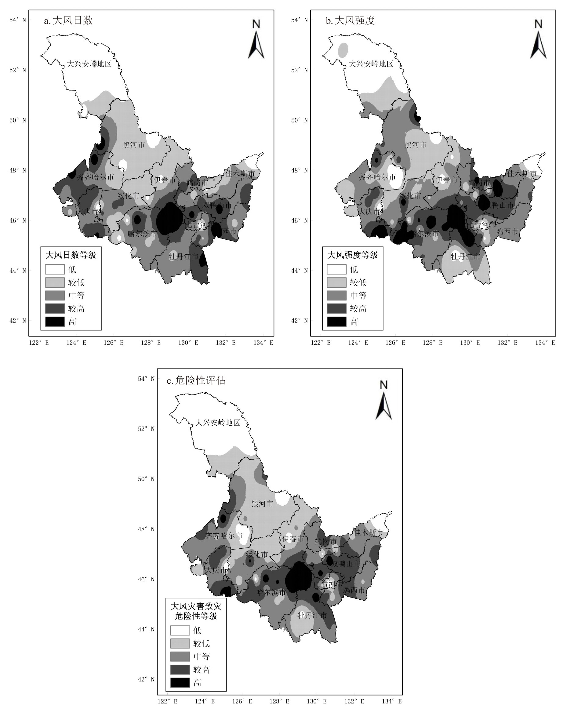
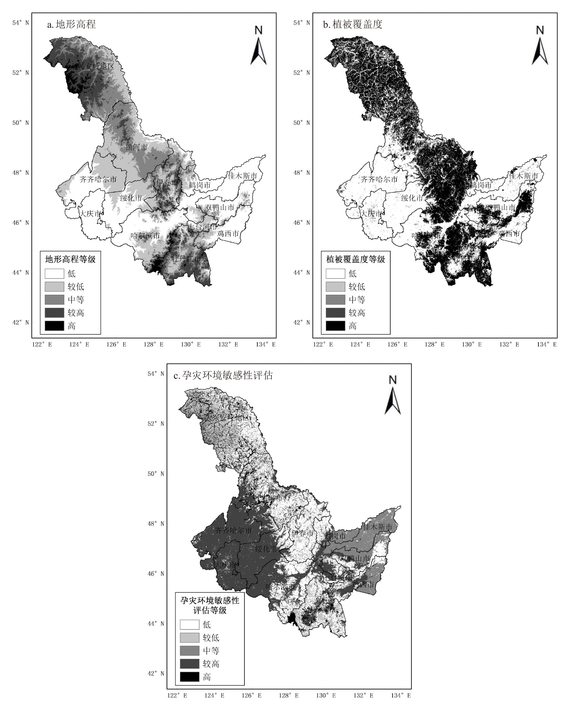
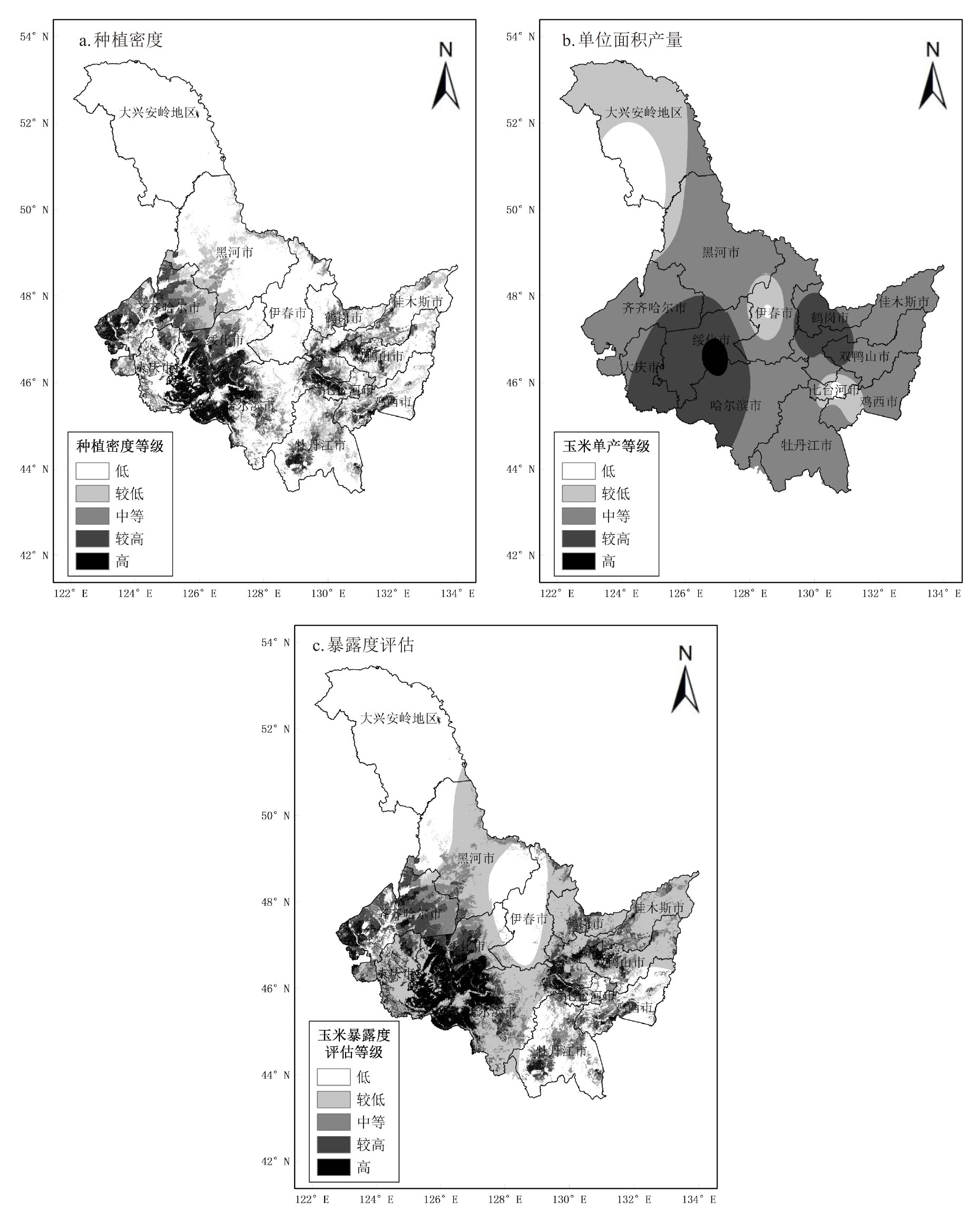
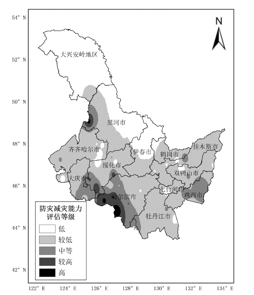
刘赫男, 张洪玲, 朱红蕊, 等. 黑龙江省大风气候特征分析以及致灾危险性区划[J]. 黑龙江气象, 2023, 40(3):6-8.
|
| [28] |
徐永清, 刘赫男, 刘春生, 等. 黑龙江省玉米暴雨洪涝灾害风险评估研究[J]. 中国农学通报, 2023, 39(30):94-100.
doi: 10.11924/j.issn.1000-6850.casb2022-0880
|
| [29] |
任照环, 许伟, 余蜀豫, 等. 重庆市雷电灾害区划[J]. 中国农业资源与区划, 2020, 41(4):317-324.
|
 ), 张洪玲, 徐永清, 朱红蕊(