Welcome to Chinese Agricultural Science Bulletin,
Chinese Agricultural Science Bulletin ›› 2024, Vol. 40 ›› Issue (6): 84-90.doi: 10.11924/j.issn.1000-6850.casb2023-0233
Previous Articles Next Articles
GONG Hengrui( ), ZHENG Yuping(), MIAO Yunling
Received:2023-03-16
Revised:2023-06-03
Online:2024-02-22
Published:2024-02-22
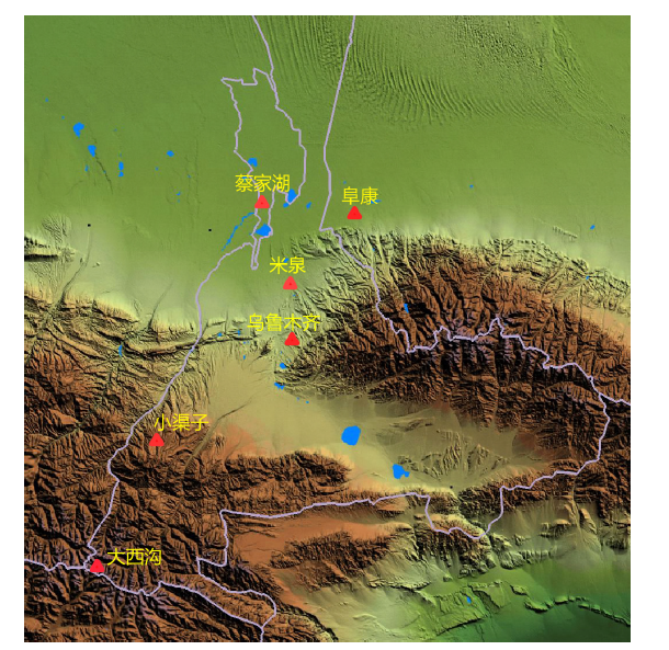
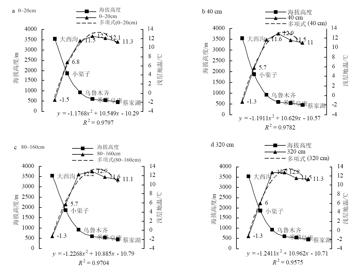
GONG Hengrui, ZHENG Yuping, MIAO Yunling. The Distribution Characteristics of Soil Temperature at Different Altitudes in Northern Slope Fault Zone of the Middle Tianshan Mountain in Xinjiang[J]. Chinese Agricultural Science Bulletin, 2024, 40(6): 84-90.
Add to citation manager EndNote|Ris|BibTeX
URL: https://www.casb.org.cn/EN/10.11924/j.issn.1000-6850.casb2023-0233


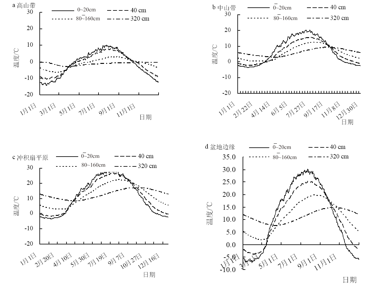
| 土壤层次 | 土壤温度的垂直变化率 | ||
|---|---|---|---|
| 3539~600 m | 600~441 m | ||
| 0~20 cm | 春季(3—5月) | -0.51 | 1.06 |
| 夏季(6—8月) | -0.73 | 1.13 | |
| 秋季(9—11月) | -0.42 | 0.38 | |
| 冬季(12—翌年2月) | -0.25 | 0.63 | |
| 年 | -0.48 | 0.75 | |
| 40 cm | 春季(3—5月) | -0.47 | 1.44 |
| 夏季(6—8月) | -0.70 | 1.88 | |
| 秋季(9—11月) | -0.47 | 0.63 | |
| 冬季(12—翌年2月) | -0.26 | 0.56 | |
| 年 | -0.48 | 1.25 | |
| 80~160 cm | 春季(3—5月) | -0.41 | 1.19 |
| 夏季(6—8月) | -0.66 | 2.19 | |
| 秋季(9—11月) | -0.56 | 1.19 | |
| 冬季(12—翌年2月) | -0.31 | -0.06 | |
| 年 | -0.48 | 1.13 | |
| 320 cm | 春季(3—5月) | -0.38 | 0.44 |
| 夏季(6—8月) | -0.52 | 1.56 | |
| 秋季(9—11月) | -0.59 | 1.50 | |
| 冬季(12—翌年2月) | -0.42 | 0.13 | |
| 年 | -0.48 | 0.88 | |
| [1] |
doi: 10.1016/S0378-1127(99)00290-X URL |
| [2] |
王洋, 刘景双, 王全英. 冻融作用对土壤团聚体及有机碳组分的影响[J]. 生态环境学报, 2013, 22(7):1269-1274.
|
| [3] |
王根绪, 程国栋, 沈永平. 青藏高原草地土壤有机碳库及其全球意义[J]. 冰川冻土, 2002, 24(6):693-700.
|
| [4] |
李英年, 张法伟, 刘安花, 等. 矮嵩草草甸土壤温湿度对植被盖度变化的响应[J]. 中国农业气象, 2006, 27(4):265-268,272.
|
| [5] |
|
| [6] |
宋长春, 王毅勇. 湿地生态系统土壤温度对气温的响应特征及对CO2排放的影响[J]. 应用生态学报, 2006, 17(4):4625-4629.
|
| [7] |
doi: 10.1046/j.1365-2486.1998.00128.x URL |
| [8] |
李卫朋, 范继辉, 沙玉坤, 等. 藏北高寒草原土壤温度变化与冻融特征[J]. 山地学报, 2014, 32(4):407-416.
|
| [9] |
杨梅学, 姚檀栋, 小池俊雄. 藏北高原土壤温度分布的纬向效应和高度效应[J]. 山地学报, 1999, 17(4):329-332.
|
| [10] |
doi: 10.2307/1929010 URL |
| [11] |
杨梅学, 姚檀栋, 丁永建, 等. 藏北高原D110点不同季节土壤温度的日变化特征[J]. 地理科学, 1999, 19(6):570-574.
|
| [12] |
赵逸舟, 马耀明, 马伟强, 等. 藏北高原土壤温湿变化特征分析[J]. 冰川冻土, 2007, 29(4):578-583.
|
| [13] |
doi: 10.1007/s11629-012-2147-6 URL |
| [14] |
王雪姣, 王森, 吉春容, 等. 1961-2015年新疆 0cm地温的时空分布特征及突变分析[J]. 干旱区资源与环境, 2018, 32(4):165-169.
|
| [15] |
平措次旺, 索南才吉, 桑旦平措, 等. 珠峰地区浅层地温的变化特征—以定日县为例[J]. 高原山地气象研究, 2021, 41(1):35-40.
|
| [16] |
巩俐, 李路华, 王发科, 等. 五道梁地区浅层地温变化特征及其对冻土的影响[J]. 现代农业科技, 2020(20):159-164.
|
| [17] |
赵舒曼, 左洪超, 卫翔谦, 等. 干旱区地膜覆盖农田下垫面对东亚气候效应的数值模拟[J]. 干旱区研究, 2018, 35(2):143-153.
|
| [18] |
杨梅学, 姚檀栋,
|
| [19] |
|
| [20] |
高红贝, 邵明安. 干旱区降雨过程对土壤水分与温度变化影响研究[J]. 灌溉排水学报, 2011, 30(1):41-45.
|
| [21] |
郑伟, 刘娅楠, 孙怀琴, 等. 塔克拉玛干沙漠腹地浅层地温特征及其影响因子研究[J]. 内蒙古气象, 2019(3):27-31.
|
| [22] |
罗凤敏, 高君亮, 辛智鸣. 乌兰布和沙漠东北缘地温变化特征及其影响因子[J]. 中国沙漠, 2019, 39(1):179-186.
doi: 10.7522/j.issn.1000-694X.2018.00020 |
| [23] |
强玉柱, 蒲金涌, 刘扬, 等. 天水市近50年浅层地温变化特征分析[J]. 中国农学通报 2013, 29(35):317-322.
|
| [24] |
管延龙, 王让会, 李成, 等. 天山北麓1963-2010年0cm最高与最低地表温度变化特征[J]. 干旱气象, 2015, 33(4):587-594.
doi: 10.11755/j.issn.1006-7639(2015)-04-0587 |
| [25] |
缑倩倩, 李乔乔, 屈建军, 等. 荒漠-绿洲过渡带土壤温度变化分析[J]. 干旱区研究, 2019, 36(4):809-815.
|
| [1] | CAI Zhe, DUAN Licheng, GUO Ruige, LIU Dongmei. Characteristics of Soil Temperature Variation in Jiangxi Province and Its Relationship with Meteorological Elements [J]. Chinese Agricultural Science Bulletin, 2024, 40(4): 118-125. |
| [2] | NIU Xianqian, JIANG Li, LIN Qiujin, LIN Xiuxiang, LI Yongyu, SHI Qing. Division of Planting Areas for Superior Quality Passion Fruits in Fujian [J]. Chinese Agricultural Science Bulletin, 2023, 39(7): 40-45. |
| [3] | LI Jiaxin, GAI Weiling, SUN Xianmin, ZHAO Xin, ZHANG Xiaoguang, CUI Dejie. Spatial Distribution Characteristics and Fertility Evaluation of Soil Nutrients Based on GIS [J]. Chinese Agricultural Science Bulletin, 2023, 39(25): 94-101. |
| [4] | YU Haiyue, LIU Xinyu, ZHANG Yuxiang. The Variation Characteristics of Shallow Soil Temperature in Gansu from 1980 to 2021 [J]. Chinese Agricultural Science Bulletin, 2023, 39(13): 95-101. |
| [5] | ZHANG Junli, SUO Long, WANG Rui, LIANG Jianhong, DONG Xiaomei, JIAO Xueli, ZHANG Xiaofei, LIU Hui, HE Wei. Effects of Whole Biodegradable Film on Soil Temperature, Soil Moisture, and Sweet Potato Yield in Field [J]. Chinese Agricultural Science Bulletin, 2023, 39(12): 69-74. |
| [6] | CHEN Ruiying, ZHAO Peirong, LIU Hongjin, ZHANG Lei, GUO Xiaoyu. The Application Effect of Degradable Film in Potato Production [J]. Chinese Agricultural Science Bulletin, 2022, 38(6): 37-41. |
| [7] | YANG Miao, TIAN Yongzhu, HAN Zhiwei, LUO Guangfei, ZHAO Ran, TIAN Yutong, XIAO Han. Spatial Distribution and Formation of Phosphorus in Typical Land-use Soils in Karst Agricultural Areas [J]. Chinese Agricultural Science Bulletin, 2022, 38(29): 108-117. |
| [8] | LIU Wanling, WANG Junjie, LIN Zijun, ZENG Ting, CHEN Yimin, SUI Yueyu, JIAO Xiaoguang. Variation Characteristics of Organic Carbon in Arable Black Soil in Suihua City [J]. Chinese Agricultural Science Bulletin, 2022, 38(20): 67-72. |
| [9] | LI Yingying, ZHENG Yunke, WANG Zhunian. National Key Protected Plant Resources and Their Distribution Characteristics in Ledong County of Hainan Province [J]. Chinese Agricultural Science Bulletin, 2022, 38(19): 86-92. |
| [10] | GUO Jia, JIN Shaofei, WANG Ku. Spatial Distribution Characteristics and the Impact Factors of Heavy Metals in Peri-urban Soils Under the Background of Fast Urbanization [J]. Chinese Agricultural Science Bulletin, 2022, 38(17): 103-109. |
| [11] | Chai Chunrong, Ni Hongwei, Liu Yingnan, Zhang Rongtao, Yang Jixian. Dynamic Response of the Soil Physical and Chemical Properties Under Simulated Snow Cover in the Sanjiang Plain [J]. Chinese Agricultural Science Bulletin, 2021, 37(5): 31-37. |
| [12] | Zhao Caixia, Ciren Baizhen, Tang Lin, Yuan Yuting. The Yield and Quality of Rapeseed ( Brassica napus L.) at Different Altitudes [J]. Chinese Agricultural Science Bulletin, 2021, 37(32): 51-56. |
| [13] | Liu Wu, Mo Jiayao, Li Zheng, Wang Jiandong, Zheng Chuanwei, Zhang Lei. Climate Suitability Model of Citrus in Guangxi [J]. Chinese Agricultural Science Bulletin, 2021, 37(25): 109-114. |
| [14] | Duan Pengwei, Ma Xiaojian, Shi Haiqiang, Du Jizhuang, Qin Lizhe, Xu Guoliang, Yang Sumiao. Correlation Analysis of Fruit Quality of ‘Fuji’ Apple and Altitude [J]. Chinese Agricultural Science Bulletin, 2021, 37(22): 49-56. |
| [15] | Yang Xiang, Su Xuede, Li Pengcheng, Guo Shaojie, Li Ming. Effects of Different Mulch on Soil Temperature and Soil Water Potential in Key Growth Stages of Summer Black Grape [J]. Chinese Agricultural Science Bulletin, 2021, 37(20): 59-65. |
| Viewed | ||||||
|
Full text |
|
|||||
|
Abstract |
|
|||||