Welcome to Chinese Agricultural Science Bulletin,
Chinese Agricultural Science Bulletin ›› 2024, Vol. 40 ›› Issue (32): 135-142.doi: 10.11924/j.issn.1000-6850.casb2024-0068
Previous Articles Next Articles
HUO Jin( ), YU Huiqiao, ZHANG Shiming(), HUANG Jiujun
Received:2024-01-15
Revised:2024-06-24
Online:2024-11-15
Published:2024-11-12
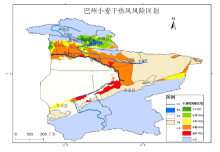
HUO Jin, YU Huiqiao, ZHANG Shiming, HUANG Jiujun. Spatiotemporal Change Characteristics and Risk Zoning of Wheat Dry Hot Wind in Bazhou of Xinjiang[J]. Chinese Agricultural Science Bulletin, 2024, 40(32): 135-142.
Add to citation manager EndNote|Ris|BibTeX
URL: https://www.casb.org.cn/EN/10.11924/j.issn.1000-6850.casb2024-0068


| [1] |
霍治国, 尚莹, 邬定荣, 等. 中国小麦干热风灾害研究进展[J]. 应用气象学报, 2019, 30(2):129-141.
|
| [2] |
王建林. 现代农业气象业务[M]. 北京: 气象出版社, 2010:168-169.
|
| [3] |
候启, 张勃, 何航, 等. 近50多年河西地区干热风事件时空变化特征[J]. 干旱区研究, 2019, 36(2):403-411.
|
| [4] |
张志红, 成林, 李书岭, 等. 干热风天气对冬小麦生理的影响[J]. 生态学杂志, 2015, 34(3):712-717.
|
| [5] |
时凤云, 徐文国, 吴建河, 等. 濮阳近40年干热风特征和成因分析及防御[J]. 中国农学通报, 2009, 25(3):251-254.
|
| [6] |
马雅丽, 栾青, 李伟伟, 等. 山西冬小麦干热风分布特征及对产量的影响[J]. 山西农业科学, 2017, 45(7):1134-1138.
|
| [7] |
成林, 张志红, 常军. 近47年来河南省冬小麦干热风灾害的变化分析[J]. 中国农业气象, 2011, 32(3):456-460,465.
|
| [8] |
喇永昌, 李丽平, 张磊. 宁夏灌区春小麦干热风灾害的时空特征[J]. 麦类作物学报, 2016, 36(4):516-522.
|
| [9] |
李洁, 张杜鹃, 李世平. 晋南冬麦区干热风发生特点及其对产量影响分析[J]. 中国农学通报, 2018, 34(6):14-18.
doi: 10.11924/j.issn.1000-6850.casb17030026 |
| [10] |
王艳云, 檀宁, 王颜海. 小麦干热风气象因素分析及应对措施[J]. 中国农技推广, 2023, 39(4):95-97.
|
| [11] |
李树军, 李楠. 近39年山东省冬小麦干热风时空规律研究[J]. 气象与环境科学, 2023, 46(2):1-8.
|
| [12] |
屈振江, 郑小华, 李星敏. 陕西省冬小麦干热风分布特征及预测研究[J]. 中国农学通报, 2013, 29(18):50-56.
|
| [13] |
宋晓辉, 薛敏, 杜亮亮, 等. 邯郸冬小麦干热风发生规律及风险预报[J]. 中国农学通报, 2017, 33(25):105-109.
doi: 10.11924/j.issn.1000-6850.casb16070134 |
| [14] |
杨晓晗. 基于机器学习的小麦干热风灾害预测研究[D]. 郑州: 河南农业大学, 2024.
|
| [15] |
李香颜, 张金平, 陈敏. 基于GIS的河南省冬小麦干热风风险评估及区划[J]. 自然灾害学报, 2017, 26(3):63-70.
|
| [16] |
王风云, 封文杰, 刘淑云, 等. 山东省小麦气象灾害风险评估模型群研发[J]. 中国农学通报, 2013, 29(20):197-204.
|
| [17] |
杨志捷, 金林雪, 武荣盛, 等. 基于GIS的内蒙古春小麦干热风风险精细化区划[J]. 干旱气象, 2019, 37(5):866-872.
|
| [18] |
冯永新, 宋玉玲, 郑玉江, 等. 准噶尔盆地西南缘干热风灾害的特征分析[J]. 农村科技, 2005(10):25.
|
| [19] |
张祖莲, 毛炜峄, 姚艳丽, 等. 2020年新疆南部区域干热风精细化特征分析[J]. 干旱区研究, 2022, 39(1):84-93.
doi: 10.13866/j.azr.2022.01.09 |
| [20] |
张学文, 张家宝. 新疆气象手册[M]. 北京: 气象出版社, 2016:208-210.
|
| [21] |
陈娟. 甘青新春麦区干热风时空变化特征及风险区划[D]. 兰州: 西北师范大学, 2020.
|
| [22] |
霍治国, 尚莹, 王纯枝, 等. QX/T 82—2019小麦干热风灾害等级[S]. 北京: 气象出版社, 2019.
|
| [23] |
邓振镛, 张强, 倾继祖, 等. 气候暖干化对中国北方干热风的影响[J]. 冰川冻土, 2009, 31(4):664-671.
|
| [24] |
小麦干热风科研协作组. 北方小麦干热风气候区划[J]. 气象, 1981(5):11-15.
|
| [25] |
马兰花, 吕新, 塔依尔. 古尔班通古特沙漠南缘增温效应研究[J]. 干旱区研究, 2007(1):108-112.
|
| [1] | YAO Jinbao, YANG Xueming, ZHANG Peng, FAN Xiangyun, YU Guihong, HE Yi, WANG Huadun. Analysis of Yield and Quality Traits of New Weak-Gluten Wheat Cultivar ‘Ningmai 36’ [J]. Chinese Agricultural Science Bulletin, 2024, 40(9): 20-24. |
| [2] | LI Qian, ZHANG Yangli, YAN Miaomiao, HAO Shuangkui, NIE Song, SUN Jie, CAO Sanchao, WANG Na. Effect of Sowing Date, Planting Density and Nitrogen Application on Population Structure and Grain Quality of ‘Weimai 9’ [J]. Chinese Agricultural Science Bulletin, 2024, 40(9): 25-29. |
| [3] | DING Hao, GAO Haitao, BI Xiangjun, LI Shengdong. Effects of Different Sowing Methods on Yield Components and Flag Leaf Photosynthetic Characteristics of Winter Wheat [J]. Chinese Agricultural Science Bulletin, 2024, 40(9): 9-19. |
| [4] | QIU Meijuan, LIU Buchun, LIU Yuan, WANG Yizhou. Spatial-temporal Variation Characteristics of Chill Accumulation in Two Major Apple Production Areas in China [J]. Chinese Agricultural Science Bulletin, 2024, 40(9): 106-116. |
| [5] | YANG Xiaolin, XUE Minfeng, ZHANG Shu, LI Jinbo, LV Liang, CHANG Xiangqian, ZHANG Youhong, GONG Yan. Analysis of Abnormal Growing Phenomena Occurred in Xiangyang District, Hubei Province: Grain-Dropping in Advance and Pole-Withered [J]. Chinese Agricultural Science Bulletin, 2024, 40(8): 112-118. |
| [6] | MA Aiping, JING Hua, KANG Xiuli, ZHAO Yukun, CUI Huanhu, HUANG Xuefang, XI Jilong. Effects of Soil Fertility Gradient and Its Indicators on Wheat Yield and Quality Traits in Hilly Areas [J]. Chinese Agricultural Science Bulletin, 2024, 40(7): 101-107. |
| [7] | ZHANG Shan, WANG Peiying, JIANG Xiaodong, CAI Chunhao, ZHENG Jianjie, YANG Zaiqiang. Study on Grain Filling Characteristics of Different Wheat Crops [J]. Chinese Agricultural Science Bulletin, 2024, 40(6): 16-21. |
| [8] | SHAO Wenqi, DONG Qingjun, DONG Yubing, ZHONG Ping, JI Li, CHEN Chuan, ZHANG Ankang. Effect of Chemical Seed Dressing on Seedling Strength and Yield of Late-sowing Wheat in Huaihe River Region [J]. Chinese Agricultural Science Bulletin, 2024, 40(6): 22-28. |
| [9] | DUAN Guohui, TIAN Wenzhong, GAO Haitao, YANG Hongqiang, ZHANG Shaolan, DONG Zhongdong, WEN Hongxia, LV Shuzuo, GU Jingjing. Effect of Different Irrigation Patterns on Stem Structure, Yield Composition and Water Use Efficiency of Winter Wheat in Huanghuai Region [J]. Chinese Agricultural Science Bulletin, 2024, 40(5): 1-8. |
| [10] | WU Yingjie, ZHU Yongchao, KONG Xiangning. Soil Moisture Inversion in Farmland Based on Landsat-8 Imagery [J]. Chinese Agricultural Science Bulletin, 2024, 40(32): 129-134. |
| [11] | XUE Zhiwei, GAO Feng, HUANG Qingqing, YANG Chunling. Migration Characteristics and Risk Assessment of Heavy Metals in Farmland Soil-Wheat System [J]. Chinese Agricultural Science Bulletin, 2024, 40(30): 48-54. |
| [12] | ZHAO Kaili, GUO Ning, LI Quanhui, LI Ping, WANG Yanping, CHEN Juan, YAN Fang, WANG Weirui. Technology and Application of Fast Fertilizing and High Yield Fertilization in Low Fertility Grain Fields in Suburbs of Beijing [J]. Chinese Agricultural Science Bulletin, 2024, 40(30): 61-65. |
| [13] | ZHANG Keyi, XIAO Hui, TIAN Xiuping, ZHANG Hui, CHENG Wenjuan, PAN Jie, DONG Yuchen. Effects of Combined Application of Cow Manure and Desulfurized Gypsum on Coastal Saline Soil and Growth of Wheat [J]. Chinese Agricultural Science Bulletin, 2024, 40(30): 66-74. |
| [14] | LI Yongli, CHEN Lei, ZHOU Zhou, GENG Shubao, QIAO Li, ZHANG Fangmei, CHEN Lijun, WANG Lijuan. Research on Control Effect of Streptomyces costaricanus Strain A-m1 on Wheat Scab [J]. Chinese Agricultural Science Bulletin, 2024, 40(30): 128-134. |
| [15] | JU Yawen, XU Peng, CHEN Yali, FU Yousheng, CAO Kaige. Effects on Wheat Seed Germination and Seedling Growth under Salt Treatment: Endophytic Fungi Fermentation Broth [J]. Chinese Agricultural Science Bulletin, 2024, 40(3): 26-32. |
| Viewed | ||||||
|
Full text |
|
|||||
|
Abstract |
|
|||||