Welcome to Chinese Agricultural Science Bulletin,
Chinese Agricultural Science Bulletin ›› 2026, Vol. 42 ›› Issue (12): 94-102.doi: 10.11924/j.issn.1000-6850.casb2025-0950
Previous Articles Next Articles
AN Yunru1,2( ), JIA Hongru1(), ZHANG Meimei3, JIN Hui’an1,4
Received:2025-11-26
Revised:2026-04-29
Online:2026-06-25
Published:2026-06-23
CLC Number:
AN Yunru, JIA Hongru, ZHANG Meimei, JIN Hui’an. Spatio-temporal Variation of Vegetation Coverage and Driving Mechanism During 2000-2022 in Shule River Basin[J]. Chinese Agricultural Science Bulletin, 2026, 42(12): 94-102.
Add to citation manager EndNote|Ris|BibTeX
URL: https://www.casb.org.cn/EN/10.11924/j.issn.1000-6850.casb2025-0950
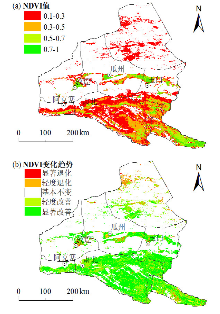
| SNDVI | Z值 | NDVI趋势变化 | 面积百分比/% |
|---|---|---|---|
| <-0.05 | <-1.96 | 显著退化 | 0.3 |
| <-0.05 | -1.96~1.96 | 轻度退化 | 2.0 |
| -0.05~0.05 | -1.96~1.96 | 基本不变 | 0.7 |
| ≥0.05 | -1.96~1.96 | 轻度改善 | 11.6 |
| ≥0.05 | ≥1.96 | 显著改善 | 21.1 |
| SNDVI | Z值 | NDVI趋势变化 | 面积百分比/% |
|---|---|---|---|
| <-0.05 | <-1.96 | 显著退化 | 0.3 |
| <-0.05 | -1.96~1.96 | 轻度退化 | 2.0 |
| -0.05~0.05 | -1.96~1.96 | 基本不变 | 0.7 |
| ≥0.05 | -1.96~1.96 | 轻度改善 | 11.6 |
| ≥0.05 | ≥1.96 | 显著改善 | 21.1 |
| 因子 | 气温 | 坡向 | 坡度 | 海拔 | 降水 | 土壤类型 | 土地利用 |
|---|---|---|---|---|---|---|---|
| 气温 | 0.333 | ||||||
| 坡向 | 0.370 | 0.029 | |||||
| 坡度 | 0.380 | 0.204 | 0.163 | ||||
| 海拔 | 0.496 | 0.377 | 0.382 | 0.339 | |||
| 降水 | 0.538 | 0.427 | 0.415 | 0.516 | 0.388 | ||
| 土壤类型 | 0.306 | 0.287 | 0.363 | 0.319 | 0.399 | 0.152 | |
| 土地利用 | 0.473 | 0.351 | 0.384 | 0.425 | 0.478 | 0.247 | 0.289 |
| 2000—2020年 | 耕地 | 林地 | 草地 | 水域 | 建设用地 | 未利用地 | 合计 |
|---|---|---|---|---|---|---|---|
| 耕地 | 1343.00 | 20.00 | 2.00 | 2.00 | 9.00 | 5.00 | 1381.00 |
| 林地 | 0.00 | 633.00 | 1.00 | 0.00 | 0.00 | 1.00 | 635.00 |
| 草地 | 140.00 | 5.00 | 26678.00 | 4.00 | 7.00 | 23.00 | 26857.00 |
| 水域 | 1.00 | 0.00 | 1.00 | 1161.00 | 0.00 | 108.00 | 1271.00 |
| 建设用地 | 0.00 | 0.00 | 0.00 | 0.00 | 234.00 | 0.00 | 234.00 |
| 未利用地 | 319.00 | 10.00 | 207.00 | 15.00 | 128.00 | 93390.00 | 94069.00 |
| 合计 | 1803.00 | 668.00 | 26889.00 | 1182.00 | 378.00 | 93527.00 | 124447.00 |
| [1] |
|
| [2] |
doi: 10.1016/S0034-4257(01)00289-9 URL |
| [3] |
陈宽, 杨晨晨, 白力嘎, 等. 基于地理探测器的内蒙古自然和人为因素对植被NDVI变化的影响[J]. 生态学报, 2021, 41(12):4963-4975.
|
| [4] |
唐荣林, 王晟力, 姜亚珍, 等. 基于地表温度—植被指数三角/梯形特征空间的地表蒸散发遥感反演综述[J]. 遥感学报, 2021, 25(1):65-82.
|
| [5] |
张翀, 雷田旺, 宋佃星. 黄土高原植被覆盖与土壤湿度的时滞关联及时空特征分析[J]. 生态学报, 2018, 38(6):2128-2138.
|
| [6] |
杨树青, 白玉川, 徐海珏, 等. 河岸植被覆盖影响下的河流演化动力特性分析[J]. 水利学报, 2018, 49(8):995-1006.
|
| [7] |
高江波, 焦珂伟, 吴绍洪. 1982—2013年中国植被NDVI空间异质性的气候影响分析[J]. 地理学报, 2019, 74(3):534-543.
doi: 10.11821/dlxb201903010 |
| [8] |
李茂华, 都金康, 李皖彤, 等. 1982—2015年全球植被变化及其与温度和降水的关系[J]. 地理科学, 2020, 40(5):823-832.
doi: 10.13249/j.cnki.sgs.2020.05.017 |
| [9] |
郑艺, 张丽, 周宇, 等. 1982—2012年全球干旱区植被变化及驱动因子分析[J]. 干旱区研究, 2017, 34(1):59-66.
|
| [10] |
冯飞, 杨鑫, 贾宝全, 等. 中国328个城市的植被覆盖度长期变化特征及其驱动因子[J]. 中国科学:地球科学, 2024, 54(2):486-502.
|
| [11] |
余涛, 庞勇, 蒙诗栎, 等. 天然林资源保护工程区植被覆盖度遥感估算及变化分析[J]. 北京林业大学学报, 2023, 45(5):1-13.
|
| [12] |
doi: 10.1016/j.rse.2013.09.011 URL |
| [13] |
冯李, 胡文英, 李应鑫, 等. Google Earth Engine在四川省多年植被覆盖度动态监测中的应用[J]. 林业资源管理, 2019(4):124-131.
|
| [14] |
靳紫含, 赵安周, 相恺政, 等. 基于GEE的关中平原城市群植被时空演变及影响因素[J]. 水土保持通报, 2023, 43(2):164-172.
|
| [15] |
黄仲良, 何敬, 刘刚, 等. 面向GEE平台的遥感影像分析与应用研究进展[J]. 遥感技术与应用, 2023, 38(3):527-534.
doi: 10.11873/j.issn.1004-0323.2023.3.0527 |
| [16] |
李晶, 闫星光, 闫萧萧, 等. 基于GEE云平台的黄河流域植被覆盖度时空变化特征[J]. 煤炭学报, 2021, 46(5):1439-1450.
|
| [17] |
郭永强, 王乃江, 褚晓升, 等. 基于Google Earth Engine分析黄土高原植被覆盖变化及原因[J]. 中国环境科学, 2019, 39(11):4804-4811.
|
| [18] |
张华, 安慧敏. 基于GEE的1987—2019年民勤绿洲NDVI变化特征及趋势分析[J]. 中国沙漠, 2021, 41(1):28-36.
doi: 10.7522/j.issn.1000-694X.2020.00094 |
| [19] |
方春爽, 朱睿, 卢睿, 等. 基于GEE的石羊河流域植被覆盖变化特征及其影响因素分析[J]. 遥感技术与应用, 2023, 38(5):1167-1179.
doi: 10.11873/j.issn.1004-0323.2023.5.1167 |
| [20] |
张军, 娄和震, 杨胜天, 等. 河道流量对疏勒河中下游河岸带植被变化的影响评价[J]. 干旱区资源与环境, 2022, 36(2):123-129.
|
| [21] |
孙栋元, 胡想全, 金彦兆, 等. 疏勒河中游绿洲天然植被生态需水量估算与预测研究[J]. 干旱区地理, 2016, 39(1):154-161.
|
| [22] |
郑续. 疏勒河流域生态系统服务评估及优化研究[D]. 兰州: 兰州大学,2021:8-11.
|
| [23] |
郭晓娟. 疏勒河流域净初级生产力与土壤含水量耦合关系研究[D]. 兰州: 兰州大学,2019:11-14.
|
| [24] |
郭廷辅. SL 190—2007,土壤侵蚀分类分级标准[S]. 北京: 中国水利水电出版社,2008:8-9.
|
| [25] |
doi: 10.1080/01431168608948945 URL |
| [26] |
doi: 10.1080/01621459.1968.10480934 URL |
| [27] |
doi: 10.1061/TACEAT.0006517 URL |
| [28] |
王劲峰, 徐成东. 地理探测器:原理与展望[J]. 地理学报, 2017, 72(1):116-134.
doi: 10.11821/dlxb201701010 |
| [29] |
戴声佩, 张勃, 王海军, 等. 基于SPOTNDVI的祁连山草地植被覆盖时空变化趋势分析[J]. 地理科学进展, 2010, 29(9):1075-1080.
|
| [30] |
齐敬辉, 牛叔文, 马利邦, 等. 2000—2014年疏勒河流域植被覆盖时空变化[J]. 生态与农村环境学报, 2016, 32(5):757-766.
|
| [31] |
doi: 10.1016/j.scitotenv.2020.142419 URL |
| [32] |
doi: 10.1016/j.ecolind.2022.108745 URL |
| [33] |
doi: 10.3390/f15071147 URL |
| [34] |
doi: 10.3390/atmos15040459 URL |
| [35] |
doi: 10.1080/10807039.2018.1528437 URL |
| [36] |
朱建海. 立足省情实际创新体制机制以“两手发力”推动甘肃水利高质量发展[J]. 水利发展研究, 2022, 22(12):52-55.
|
| [37] |
韦红钢, 周仲魁, 孙占学, 等. 疏勒河地表水水化学特征及保护措施[J]. 人民黄河, 2010, 32(11):70-71,73.
|
| [1] | XU En, SHEN Wei, ZHOU Hang, WANG Jinjie, YAN Yaqiong, YAO Haitao. NDVI Variation and Its Response to Extreme Climate in Jiangsu During 2001-2022 [J]. Chinese Agricultural Science Bulletin, 2026, 42(6): 150-163. |
| [2] | PUBU Duoji, LUOSANG Wangmu, DANZEN Yiga, ZHOU Kanshe, SHI Jiqing, ZHANG Dongdong, DANZEN Weise. Characteristics of Climate Change in Xigazê from 1992 to 2022 and Its Impact on Growth and Development of Spring Highland Barley [J]. Chinese Agricultural Science Bulletin, 2026, 42(5): 170-177. |
| [3] | WANG Ying, LI Lu, ZHU Jiayi, JIA Yuanyuan, GAO Qi, HU Zhichao. Research on Identification and Yield Estimation of Artificial Alfalfa in Green-up Period in Hohhot Based on Satellite Remote Sensing [J]. Chinese Agricultural Science Bulletin, 2026, 42(3): 125-132. |
| [4] | ZHANG Xingang. The Impact of Climate Warming on Growth, Development, and Yield of Winter Wheat in Northern Henan Province-Taking Qinyang City as an Example [J]. Chinese Agricultural Science Bulletin, 2025, 41(3): 98-106. |
| [5] | HU Qirui, JI Chunrong, GAO Jian. Analysis of Growth Meteorological Conditions and Main Meteorological Disasters of Korla Fragrant Pear [J]. Chinese Agricultural Science Bulletin, 2025, 41(3): 91-97. |
| [6] | WANG Yue, FEI Wenli, CHENG Jun, SHEN Lidu, ZOU Xiuming, ADIL Alim. Meteorological Elements Variation Trends and Meteorological Yield Prediction Model for Maize at Different Growth Stages in Shenyang [J]. Chinese Agricultural Science Bulletin, 2025, 41(15): 95-101. |
| [7] | WANG Miaomiao, WANG Beibei, LI Mingfang, ZHANG Zhihong, YAN Xue. Research Progress on Winter Wheat Growth Period Recognition Methods [J]. Chinese Agricultural Science Bulletin, 2025, 41(1): 1-7. |
| [8] | FAN Peng, YANG Qingwei, GAO Chao, LI Di, WANG Lei, YANG Xihui. Correlation Analysis Between Soil Organic Matter Content and Grain Yield: A Case Study of Lankao County in Henan [J]. Chinese Agricultural Science Bulletin, 2024, 40(32): 77-84. |
| [9] | CHEN Chang, LIU Xingli, JIANG Lixia, LOU Dejun, WANG Yongchao, ZHU Yumei, LI Yi, LI Wenjing. Study on Relationship Between Meteorological Factors and Grain Crops in Drought-Prone Areas of Songnen Plain from 1971 to 2020 [J]. Chinese Agricultural Science Bulletin, 2024, 40(29): 103-112. |
| [10] | YIN Jiaqi, ZHANG Mei, LUO Jianyu, CHEN Yuguang, YANG Xinhong, DONG Yuxin. Study on Relationship Between Coix Seed Vegetation Index and Meteorological Factors at Pixel Scale [J]. Chinese Agricultural Science Bulletin, 2024, 40(26): 66-72. |
| [11] | ZHANG Huijing, ZHOU Xiuhua, QIN Chuan. Variation Characteristics and Trend Prediction of Winter Agroclimatic Resources in Baise City [J]. Chinese Agricultural Science Bulletin, 2024, 40(17): 81-88. |
| [12] | SHANG Junlin, LEI Jun, YAO Yubi, YAO Rui, LU Guoyang, LUAN Zhenbin, CHANG Jinhui. Variation Characteristics of Sunshine Duration from 1961 to 2020 in Dingxi [J]. Chinese Agricultural Science Bulletin, 2023, 39(5): 116-123. |
| [13] | ZHU Shengcui, LI Guoting, WEI Yonglin, MA Fulin, JIN Xianling, CAO Yingmin. Study on Predicting Models of Grass Yield in North Shore of Qinghai Lake [J]. Chinese Agricultural Science Bulletin, 2023, 39(25): 109-115. |
| [14] | MA Su, CUI Guoyi, ZHAO Yu, ZHAO Ying, LIU Xuezhen, ZHANG Chengdong. Spatial-temporal Variation Characteristics of NPP and the Driving Factors: A Case Study of Yan’an [J]. Chinese Agricultural Science Bulletin, 2022, 38(19): 93-98. |
| [15] | Wu Wenyan, Cheng Zhichao, Li Mengsha, Sui Xin, Zeng Xiannan. Development of Rhizobium Based on Web of Science [J]. Chinese Agricultural Science Bulletin, 2021, 37(9): 109-117. |
| Viewed | ||||||
|
Full text |
|
|||||
|
Abstract |
|
|||||