| [1] |
刘康, 欧阳志云, 王效科, 等. 甘肃省生态环境敏感性评价及其空间分布[J]. 生态学报, 2003(12):2711-2718.
|
| [2] |
黄心怡, 赵小敏, 郭熙, 等. 基于生态系统服务功能和生态敏感性的自然生态空间管制分区研究[J]. 生态学报, 2020, 40(3):1065-1076.
|
| [3] |
潘竟虎, 董晓峰. 基于GIS的黑河流域生态环境敏感性评价与分区[J]. 自然资源学报, 2006(2):267-273.
|
| [4] |
宋晓龙, 李晓文, 白军红, 等. 黄河三角洲国家级自然保护区生态敏感性评价[J]. 生态学报, 2009, 29(9):4836-4846.
|
| [5] |
赵杨. 城市生态环境敏感性评价——以瓦房店市为例[J]. 环境科学导刊, 2019, 38(3):66-69.
|
| [6] |
李阳兵, 邵景安, 王世杰, 等. 基于岩溶生态系统特性的水土流失敏感性评价[J]. 山地学报, 2007(6):671-677.
|
| [7] |
赵明月, 赵文武, 靳婷, 等. 青海湖流域土地沙漠化敏感性评价[J]. 中国农学通报, 2012(32):237-242.
|
| [8] |
王宏, 塔西甫拉提·特依拜, 谢霞, 等. 新疆艾比湖地区不同土地利用类型的土壤盐渍化敏感性评价[J]. 地理科学进展, 2011, 30(5):593-599.
|
| [9] |
贺秋华, 张丹, 陈朝猛, 等. GIS支持下的黔中地区生态环境敏感性评估[J]. 生态学杂志, 2007, 26(3):413-417.
|
| [10] |
管青春, 郝晋珉, 王宏亮, 等. 经济转型视角下矿产资源城市生态敏感性评价[J]. 农业工程学报, 2018, 34(21):253-262.
|
| [11] |
李龙, 吴大放, 王芳, 等. 中国快速城市化区域生态系统服务价值预测及权衡研究——以佛山市为例[J]. 生态学报, 2020(24):1-14.
|
| [12] |
欧阳志云, 王效科, 苗鸿. 中国生态环境敏感性及其区域差异规律研究[J]. 生态学报, 2000(1):10-13.
|
| [13] |
武鹏达, 鲁学军, 侯伟, 等. GIS支持下土地生态环境敏感性评价—以金坛市为例[J]. 测绘科学, 2016, 41(2):81-86.
|
| [14] |
裴晶莹, 王英伟, 裴林红. 基于3S技术的林业县生态环境敏感性研究—以萝北县为例[J]. 环境科学与管理, 2020, 45(7):175-179.
|
| [15] |
李磊, 贾磊, 赵晓雪, 等. 层次分析—熵值定权法在城市水环境承载力评价中的应用[J]. 长江流域资源与环境, 2014, 23(4):456-460.
|
| [16] |
刘春霞, 李月臣, 杨华, 等. 三峡库区重庆段生态与环境敏感性综合评价[J]. 地理学报, 2011, 66(5):631-642.
|
| [17] |
熊善高, 秦昌波, 于雷, 等. 基于生态系统服务功能和生态敏感性的生态空间划定研究——以南宁市为例[J]. 生态学报, 2018, 38(22):7899-7911.
|
| [18] |
GOVAERT L, PANTEL J H, De MEESTER L. Eco-evolutionary partitioning metrics: assessing the importance of ecological and evolutionary contributions to population and community change[J]. Ecology letters, 2016, 19(8).
|
| [19] |
孙艳玲, 郭鹏. 1982—2006年华北植被覆盖变化及其与气候变化的关系[J]. 生态环境学报, 2012, 21(1):7-12.
|
| [20] |
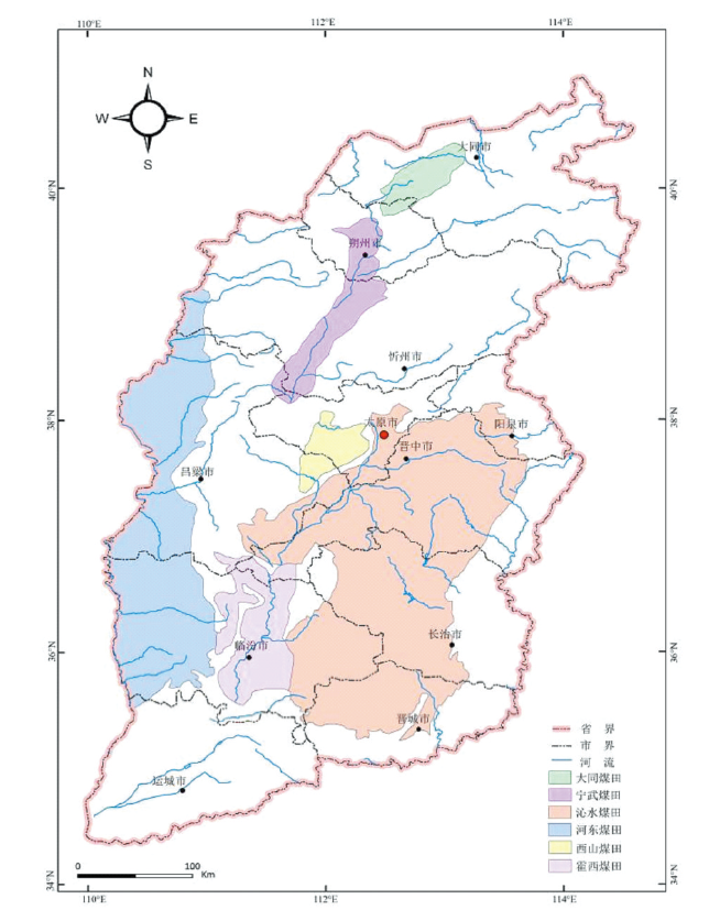
时红. 山西煤矿的生态环境问题及其对策[J]. 重庆环境科学, 2002(2):11-13.
|
| [21] |
郑子豪, 陈颖彪, 千庆兰, 等. 基于三维模型的城市局地微气候模拟[J]. 地球信息科学学报, 2016, 18(9):1199-1208.
doi: 10.3724/SP.J.1047.2016.01199
|
| [22] |
张立伟, 傅伯杰, 吕一河, 等. 基于综合指标法的中国生态系统服务保护有效性评价研究[J]. 地理学报, 2016, 71(5):768-780.
doi: 10.11821/dlxb201605006
|
| [23] |
李粉玲, 常庆瑞, 申健, 等. 黄土高原沟壑区生态环境状况遥感动态监测——以陕西省富县为例[J]. 应用生态学报, 2015, 26(12):3811-3817.
|
| [24] |
简卿, 张立强, 崔海宁, 等. 青龙满族自治县生态敏感性评价及区划[J]. 中国农业资源与区划, 2017, 38(11):171-178.
|
| [25] |
刘军会, 高吉喜, 马苏, 等. 内蒙古生态环境敏感性综合评价[J]. 中国环境科学, 2015, 35(2):591-598.
|
| [26] |
刘连友, 王建华, 李小雁, 等. 耕作土壤可蚀性颗粒的风洞模拟测定[J]. 科学通报, 1998(15):3-5.
|
| [27] |
汪邦稳, 杨勤科, 刘志红, 等. 延河流域退耕前后土壤侵蚀强度的变化[J]. 中国水土保持科学, 2007(4):27-33.
|
| [28] |
杨维, 刘云国, 曾光明, 等. 定量遥感支持下的红壤丘陵区土壤侵蚀敏感性评价—以长沙市为例[J]. 环境科学与管理, 2007(1):120-125.
|
| [29] |
余文昌. 湖北省生态保护红线与生态空间管治研究[D]. 武汉:华中师范大学, 2018.
|
| [30] |
王天宇, 惠怡安, 师莹, 等. 人为干扰度视角下黄土丘陵沟壑区延河流域景观格局演变预测及优化—以陕西省延长县为例[J]. 水土保持通报, 2020, 40(5):1-8.
|
| [31] |
梁发超, 刘黎明. 景观格局的人类干扰强度定量分析与生态功能区优化初探——以福建省闽清县为例[J]. 资源科学, 2011, 33(6):1138-1144.
|
| [32] |
陈爱莲, 朱博勤, 陈利顶, 等. 双台河口湿地景观及生态干扰度的动态变化[J]. 应用生态学报, 2010, 21(5):1120-1128.
|
| [33] |
康秀亮, 刘艳红. 生态系统敏感性评价方法研究[J]. 安徽农业科学, 2007(33):10569-10571.
|
 ), 潘换换2, 吴树荣2, 杜自强2(