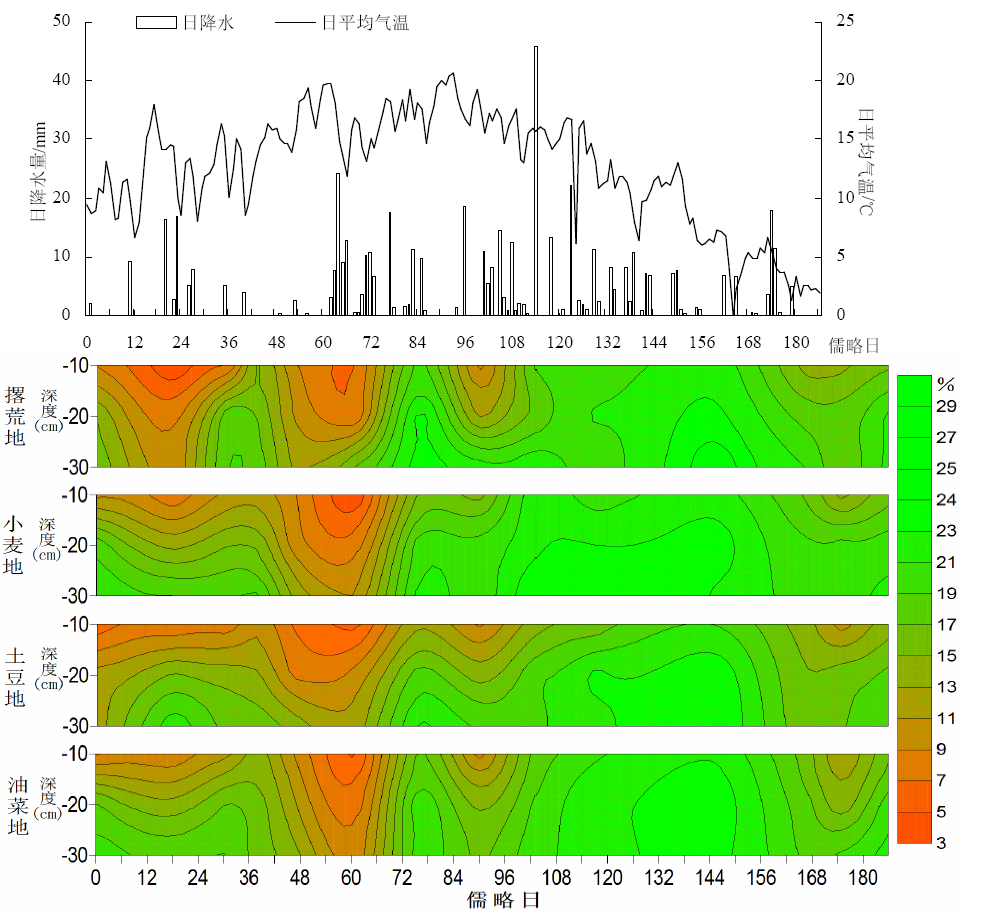
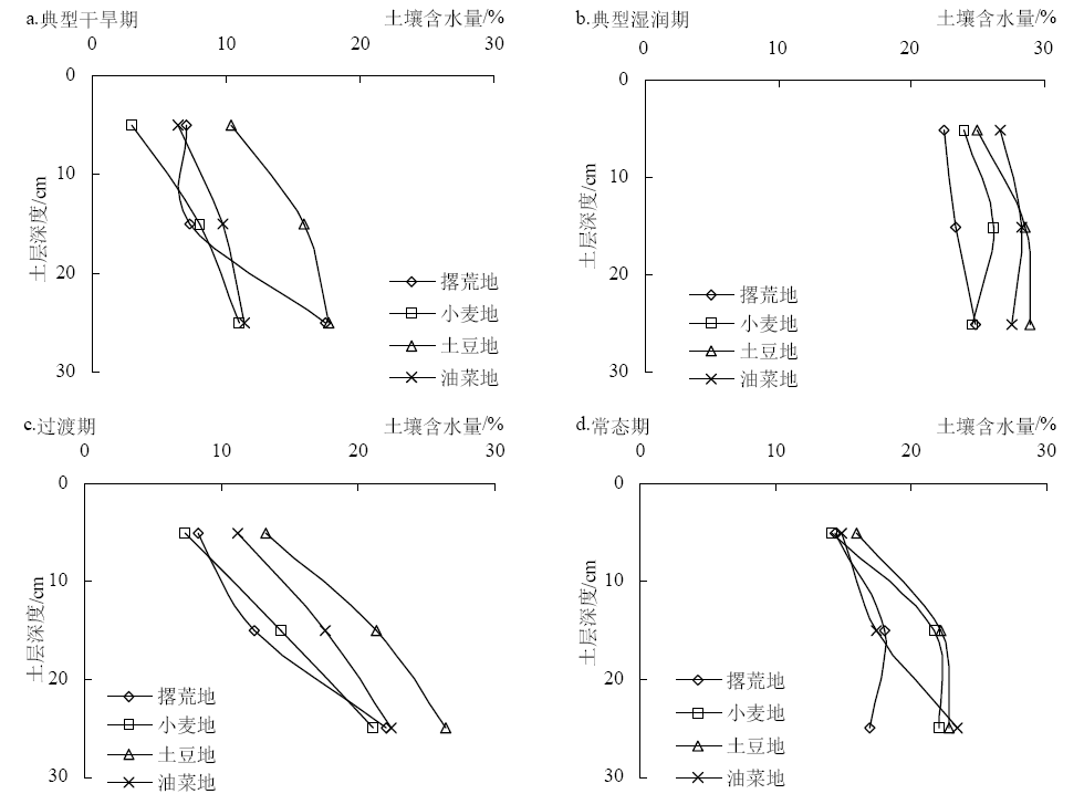
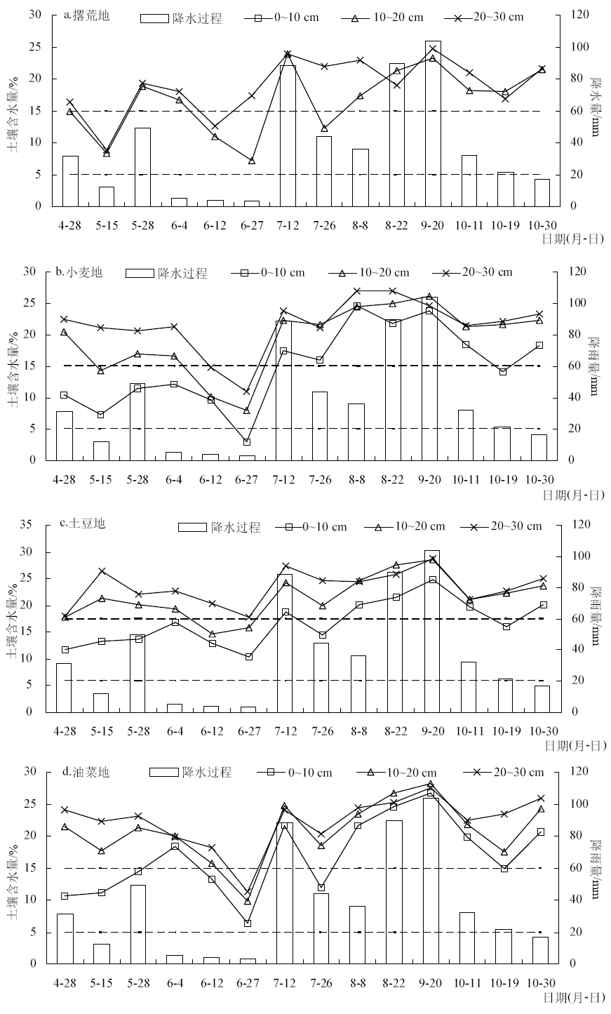
| [1] |
余峰, 董立国, 赵庆丰 , 等. 宁夏半干旱地区梯田土壤水分动态变化规律研究[J]. 水土保持研究, 2007,14(1):298-300,304.
|
| [2] |
蓟尚玛, 郭连云 . 青海贵德旱作区春秋季土壤水分变化特征[J]. 中国农学通报, 2016,32(14):159-163.
|
| [3] |
Seneviratne S I, Corti T, Davin E L , et al. Investigating soil moisture-climate interactions in a changing climate: a review[J]. Earth-Science Reviews, 2010,99(3/4):125-161.
|
| [4] |
苏子龙, 张光辉, 于艳 . 东北典型黑土区不同土地利用方式土壤水分动态变化特征[J]. 地理科学, 2013,33(9):1104-1110.
|
| [5] |
Legates D R, Mahmood R, Levia D F , et al. Soil moisture:a central and unifying theme in physical geography[J]. Progress in Physical Geography, 2010,35(1):65-86.
|
| [6] |
何其华, 何永华, 包维楷 . 干旱半干旱区山地土壤水分动态变化[J]. 山地学报, 2003,21(2):149-156.
|
| [7] |
Porporato A, Rodriguez-Iturbe I . Ecohydrology: a challenging multidisciplinary research perspective[J]. Hydrological Sciences Journal-Journal des Sciences Hydrologiques, 2002,47(5):811-822.
|
| [8] |
宋乃平, 杨明秀, 王磊 , 等. 荒漠草原区人工柠条林土壤水分周年动态变化[J]. 生态学杂志, 2014,33(10):2618-2624.
|
| [9] |
易彩琼, 王胜, 樊军 . 黄土高原坡地退耕恢复草地的土壤水分动态[J]. 草地学报, 2015,23(6):1182-1189.
|
| [10] |
茹豪, 张建军, 张琦 , 等. 晋西黄土区雨养果园土壤水分动态及对降雨的响应[J]. 水土保持学报, 2014,28(1):36-42.
|
| [11] |
季定民, 张勃, 王东 , 等. 甘肃河东玉米种植区春夏气象干旱时空变化特征及其与环流因子关系[J]. 自然资源学报, 2015,30(9):1547-1557.
|
| [12] |
王丽莉 . 青海省东部干旱风险及对春小麦种植的影响[D]. 南京:南京信息工程大学, 2017.
|
| [13] |
张国胜, 李林, 徐维新 , 等. 青海省东部农业区旱地土壤水分演变特征分析[J]. 中国沙漠, 2000,20(3):314-316.
|
| [14] |
周瑶 . 青海省ET0的简化计算与预测模型研究[D]. 杨凌:西北农林科技大学, 2013.
|
| [15] |
陈斐, 王润元, 王鹤龄 , 等. 干旱胁迫下春小麦干物质积累和分配及其模拟[J]. 干旱区研究, 2017,34(6):1418-1425.
|
| [16] |
王娟, 江天才, 万素梅 . 水分胁迫下间作棉田土壤水分及产量分析[J]. 干旱区研究, 2016,33(1):89-93.
|
| [17] |
Sala O E, Lauenroth W K, Parton W J . Long-term soilwater dynamics in the shortgrass steppe[J]. Ecology, 1992,73(4):1175-1181.
|
| [18] |
杨淑香 . 农牧林交错带不同降水年型下土壤水分动态研究[J]. 干旱区资源与环境, 2015,29(7):107-110.
|
| [19] |
侯大山, 刘玉华, 王云超 . 冀西北高原不同植被的土壤水分动态变化研究[J]. 中国农学通报, 2007,23(3):271-274.
|
| [20] |
鲍彪, 毕华兴, 云雷 , 等. 晋西黄土区刺槐林地土壤水分对降雨的响应[J]. 北京林业大学学报, 2012,34(2):84-89.
|
| [21] |
常昌明, 牛建明, 王海 , 等. 小针茅荒漠草原土壤水分动态及其对降雨的响应[J]. 干旱区研究, 2016,33(2):260-265.
|
| [22] |
原鹏飞, 丁国栋, 王炜炜 , 等. 毛乌素沙地降雨入渗和蒸发特征[J]. 中国水土保持科学, 2008,6(4):23-27.
|
| [23] |
乔斌, 何彤慧, 吴春燕 , 等. 银川平原沟渠边坡土壤理化性状空间分异特征[J]. 干旱地区农业研究, 2018,36(1):43-49,60.
|
| [24] |
朱海, 胡顺军, 陈永宝 . 古尔班通古特沙漠南缘固定沙丘土壤水分时空变化特征[J]. 土壤学报, 2016,53(1):117-126.
|
| [25] |
唐敏, 赵西宁, 高晓东 , 等. 黄土丘陵区不同土地利用类型土壤水分变化特征[J]. 2018,29(3):765-774.
|
| [26] |
陈林, 王磊, 张庆霞 , 等. 风沙区不同土地利用类型的土壤水分灰色关联分析[J]. 干旱区研究, 2009,26(6):840-845.
|