Welcome to Chinese Agricultural Science Bulletin,
Chinese Agricultural Science Bulletin ›› 2020, Vol. 36 ›› Issue (7): 76-82.doi: 10.11924/j.issn.1000-6850.casb20190900654
Previous Articles Next Articles
Wang Bingzhe1, Bi Rutian1( ), Chen Ligen1,2(), Jing Yaodong1
Received:2019-09-17
Revised:2019-11-06
Online:2020-03-05
Published:2020-03-02
Contact:
Rutian Bi,Ligen Chen
E-mail:brt@sxau.edu.cn;njaulgchen@126.com
CLC Number:
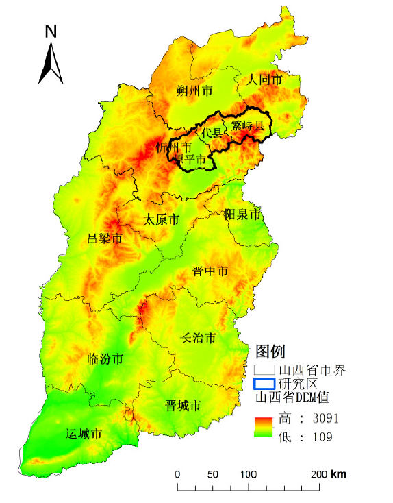
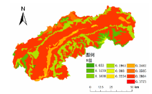
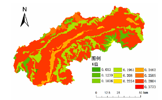
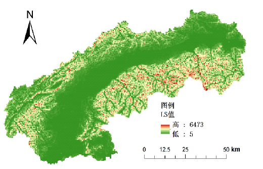
Wang Bingzhe, Bi Rutian, Chen Ligen, Jing Yaodong. Soil Erosion in Loess Area of the Upstream of the Hutuo River: Spatial Characteristics Based on USLE Model[J]. Chinese Agricultural Science Bulletin, 2020, 36(7): 76-82.
Add to citation manager EndNote|Ris|BibTeX
URL: https://www.casb.org.cn/EN/10.11924/j.issn.1000-6850.casb20190900654


| [1] | 王莉娜, 李文龙, 王素芳 , 等. 基于遥感和USLE模型的2000-2010年甘肃省土壤侵蚀变化评价[J]. 草业科学, 2016,33(02):176-183. |
| [2] | 杨勤科, 李锐, 刘咏梅 . 区域土壤侵蚀普查方法的初步讨论[J]. 中国水土保持科学, 2008,6(03):1-6. |
| [3] | 杨琴 . 基于USLE的喀斯特地区水土流失定量监测研究[D]. 贵州:贵州师范大学, 2008. |
| [4] | 杨勤科, 李锐 . 中国水土流失和水土保持定量研究进展[J]. 水土保持通报, 1998,1(05):14-19. |
| [5] | Wischmeier.W H, Smith.D D . Predicting rainfall-ero-sion losses from cropland east of the Rocky Mousntains:A Guide to conservation planning[M]. Washington DC:USDA Agric.Handb, 1978. |
| [6] | 彭双云, 杨昆, 洪亮 , 等. 基于USLE模型的滇池流域土壤侵蚀时空演变分析[J]. 农业工程学报, 2018,34(10):138-146,305. |
| [7] | Hickey R, Smith A, Jankowski P . Slope length calculation from a DEM within ARC/INFO grid[J]. Computers, Environmentand Urban Systems, 1994,18(5):365-380. |
| [8] | Van Remortel R D, Maichle R W, Hickey R J . Computing the LS factor for the Revised Universal Soil Loss Equation through array-based slope processing of digital elevation data using a C ++ executable [J]. Computers and Geosciences, 2004,30(9):1043-1053. |
| [9] | 曹龙熹, 符素华 . 基于DEM的坡长计算方法比较分析[J]. 水土保持通报, 2007,27(5):58-62. |
| [10] | 董林垚, 郑艳霞, 程冬兵 , 等. 气候变化对降雨侵蚀力的影响研究综述[J]. 长江科学院院报, 2015,32(3):59-63. |
| [11] | 寻瑞, 王克林, 于闽 , 等. 基于侵蚀降雨特征的湘江流域R因子修正算法[J]. 中国水土保持科学, 2012,10(1):32-37. |
| [12] | Sharply A N, Williams J R . Epic-erosion Productivity Impact Calculator: I. Model Documentation[M]. Washington DC: U S Department of Agriculture, 1990. |
| [13] | 王略, 屈创, 赵国栋 . 基于中国土壤流失方程模型的区域土壤侵蚀定量评价[J]. 水土保持通报, 2018,38(1):122-125,130. |
| [14] | 高峰, 华璀, 卢远 , 等. 基于GIS和USLE的钦江流域土壤侵蚀评估[J]. 水土保持研究, 2014,21(1):18-22,28. |
| [15] | 王秋霞 . 花岗岩区崩壁土体水力侵蚀特征研究[D]. 武汉:华中农业大学, 2018. |
| [16] | 门明新, 赵同科, 彭正萍 , 等. 基于土壤粒径分布模型的河北省土壤可蚀性研究[J]. 中国农业科学, 2004,37(11):1647-1653. |
| [17] | 刘新华 . 区域水土流失地形因子分析与提取研究[D]. 杨凌:西北农林科技大学, 2001. |
| [18] | 江忠善, 李秀英 . 黄土高原土壤流失预报方程中降雨侵蚀力和地形因子的研究[J]. 中国科学院西北水土保持研究所集刊, 1988,7(1):40-45. |
| [19] | 王国芳 . 基于遥感技术的植被覆盖度的动态监测[J]. 山西农业科学, 2015,43(5):592-595. |
| [20] | 耿豪鹏, 潘保田, 王超 , 等. 基于GIS与USLE的榆中县土壤侵蚀[J]. 兰州大学学报:自然科学版, 2009,45(6):8-13. |
| [21] | 邱扬, 傅伯杰, 王勇 . 土壤侵蚀时空变异及其与环境因子的时空关系[J]. 水土保持学报, 2002,16(1):108-111. |
| [22] | 倪晋仁, 李英奎 . 基于土地利用结构变化的水土流失动态评估[J]. 地理学报, 2001,56(5):610-620. |
| [23] | 潘建平 . RUSLE及其影响因子的快速计算分析[J]. 地质灾害与环境保护, 2008,19(1):88-92. |
| [24] | 曹胜, 欧阳梦云, 周卫军 , 等. 基于GIS和USLE的宁乡市土壤侵蚀定量评价[J]. 中国农业大学学报, 2018,23(12):149-157. |
| [25] | 张建香, 张勃, 张华 , 等. 黄土高原的景观格局变化与水土流失研究——以黄土高原马莲河流域为例[J]. 自然资源学报, 2011,26(9):1513-1525. |
| [26] | 游松财, 李文卿 . GIS支持下的土壤侵蚀量估算——以江西省泰和县灌溪乡为例[J]. 自然资源学报, 1999,14(1):63-69. |
| [27] | 蔡崇法, 丁树文, 史志华 , 等. 应用USLE模型与地理信息系统IDRISI预测小流域土壤侵蚀量的研究[J]. 水土保持学报, 2000,14(2):19-24. |
| [28] | 王晗生, 刘国彬, 王青宁 . 流域植被整体防蚀作用及景观结构剖析[J]. 水土保持学报, 2000,14(5):73-77,97. |
| [29] | 中华人民共和国水利部. SL 190—2007,土壤侵蚀分类分级标准[S]. 北京: 中国水利水电出版社, 2008. |
| [30] | 朱洪芬, 杨营, 毕如田 . 基于GIS和RS的繁峙县土壤侵蚀研究[J]. 中国农业资源与区划, 2014,35(5):44-47,60. |
| [31] | 余宇航 . 小流域土壤抗蚀性特征及水土流失定量预测研究[D]. 长沙:湖南农业大学, 2010. |
| [1] | HU Shuai, LUO Liping, SUN Meng, YANG Yu, WEN Junbao. Combined Control of Semanotus bifasciatus by Pyemotes zhonghuajia and Scleroderma guani [J]. Chinese Agricultural Science Bulletin, 2023, 39(1): 107-111. |
| [2] | MA Yuanhua, YIN Caixia, WANG Hongyu, LIU Yuxuan, LIU Qiantong, ZHANG Ze. Estimation Model of Cotton Leaf Phosphorus Content Based on Hyperspectral Reflectance [J]. Chinese Agricultural Science Bulletin, 2023, 39(1): 123-132. |
| [3] | SUN Shuqing, DING Wei, SUN Rui, ZHANG Xicai, LAN Guoyu, CHEN Wei, YANG Chuan, WU Zhixiang. Soil Bacterial Community of Rubber Plantations of Different Ages of Stand: Composition and Diversity Study [J]. Chinese Agricultural Science Bulletin, 2022, 38(9): 93-100. |
| [4] | SUN Bo, LIU Run, WANG Zhanbin, CHEN Huangxin, YAN Su. The Powdery Mildew on Polygonum persicaria L.: Microscopic Observation and Phylogenetic Relationship Analysis [J]. Chinese Agricultural Science Bulletin, 2022, 38(9): 130-136. |
| [5] | MA Meng, WANG Kehua, QU Liang, DOU Taocun, GUO Jun, WANG Xingguo, HU Yuping, LU Jian. Determination and Analysis of Slaughter Performance, Chest Muscle Quality and Composition of Different Chicken Breeds [J]. Chinese Agricultural Science Bulletin, 2022, 38(9): 137-142. |
| [6] | HONG Bo, ZHANG Ze, ZHANG Qiang, MA Yiru, YI Xiang, LV Xin. The Nitrogen Content in Cotton Leaves: Estimation Based on Digital Image [J]. Chinese Agricultural Science Bulletin, 2022, 38(9): 49-55. |
| [7] | ZHANG Jie, ZHU Zhihua, ZHANG Hui, HU Meng, QIU Chen, CAI Xianwen. Wild Bird Investigation and Epidemic Prevention and Control in Shandong Nansi Lake Nature Reserve [J]. Chinese Agricultural Science Bulletin, 2022, 38(9): 75-80. |
| [8] | SUN Ge, JIE Weiguang, HU Wei, ZHANG Yingzhi, QIAO Wei, WEI Lina, JIANG Yitong, BAI Li. Effects of Mycorrhizal Fungi and Mycorrhizal Helper Bacteria on Crop Development: A Review [J]. Chinese Agricultural Science Bulletin, 2022, 38(9): 88-92. |
| [9] | ZHANG Tengshuai, ZHANG Yanying, LIU Jingguo. Effect of Seasonal Variation on Intestinal Microflora of Free-range Luhua Chicken Analyzed by DGGE [J]. Chinese Agricultural Science Bulletin, 2022, 38(8): 129-134. |
| [10] | GONG Yongyong, DUANMU Huizi. TIFY Gene Family in Sugar Beet: Whole Genome Identification and Bioinformatics Analysis [J]. Chinese Agricultural Science Bulletin, 2022, 38(8): 17-24. |
| [11] | LU Lilan, WANG Yuping, YIN Xinxing, HUANG Yingkai, FAN Haikuo. Investigation and Evaluation of Soil Nutrients in Fruit Coconut Orchards in Hainan Province [J]. Chinese Agricultural Science Bulletin, 2022, 38(8): 72-80. |
| [12] | JIANG Jia, CHEN Jinpeng, WEI Jiangqiao, GUO Xuhao, CHE Zhiping, TIAN Yue’e, CHEN Genqiang, LIU Shengming. Synergistic Effect of Fludioxonil and Tebuconazole Against Fusarium graminearum [J]. Chinese Agricultural Science Bulletin, 2022, 38(6): 116-120. |
| [13] | YU Jiayue, CHEN Rao, JIA Tianyu. Farmers’ Satisfaction with Professional Cooperatives and Its Influencing Factors: A Survey of Huairou District in Beijing [J]. Chinese Agricultural Science Bulletin, 2022, 38(6): 141-148. |
| [14] | HAO Jianyu, WANG Weijun, CHEN Wenchao, LIU Jingkun, WANG Yan, KOU Hongli, WANG Zunwen. Effects of Different Treatments on the Growth of ‘Miguang’ Grape [J]. Chinese Agricultural Science Bulletin, 2022, 38(6): 48-57. |
| [15] | LI Xiang, WANG Yongping, WANG Yaofeng, CHU Chunnian, SUN Xijun, KE Xiheng, ZENG Qiao. Study on the Best Composting Parameters and Fertilization Effect of Branch Organic Fertilizer [J]. Chinese Agricultural Science Bulletin, 2022, 38(6): 63-68. |
| Viewed | ||||||
|
Full text |
|
|||||
|
Abstract |
|
|||||