Welcome to Chinese Agricultural Science Bulletin,
Chinese Agricultural Science Bulletin ›› 2021, Vol. 37 ›› Issue (19): 134-142.doi: 10.11924/j.issn.1000-6850.casb2020-0229
Special Issue: 油料作物
Previous Articles Next Articles
Wang Jun1( ), Jiang Yun2()
Received:2020-07-01
Revised:2020-09-09
Online:2021-07-05
Published:2021-07-29
Contact:
Jiang Yun
E-mail:dreamgis@163.com;remotesense@163.com
CLC Number:
Wang Jun, Jiang Yun. Inversion of Soybean Leaf Area Index Based on UAV Multispectral Remote Sensing[J]. Chinese Agricultural Science Bulletin, 2021, 37(19): 134-142.
Add to citation manager EndNote|Ris|BibTeX
URL: https://www.casb.org.cn/EN/10.11924/j.issn.1000-6850.casb2020-0229

| 参数 | 数值 |
|---|---|
| 质量 | 180 g |
| 尺寸 | 12.1 cm×6.6 cm×4.6 cm |
| 外部电源 | 5.0 V DC,4 W(8 W峰值) |
| 光谱波段 | 蓝色,绿色,红色,红色边缘,近红外(全球快门,窄带) |
| RGB颜色输出 | 3.6 MP(全局快门,与所有波段对齐 |
| 地面采样距离(GSD) | 每像素8 cm(每带)120 m AGL |
| 捕获速率 | 每秒捕获1次(所有波段),12位RAW |
| 接口 | 串行、以太网、WiFi、外部触发器、GPS |
| 视野 | 47.2°HFOV |
| 参数 | 数值 |
|---|---|
| 质量 | 180 g |
| 尺寸 | 12.1 cm×6.6 cm×4.6 cm |
| 外部电源 | 5.0 V DC,4 W(8 W峰值) |
| 光谱波段 | 蓝色,绿色,红色,红色边缘,近红外(全球快门,窄带) |
| RGB颜色输出 | 3.6 MP(全局快门,与所有波段对齐 |
| 地面采样距离(GSD) | 每像素8 cm(每带)120 m AGL |
| 捕获速率 | 每秒捕获1次(所有波段),12位RAW |
| 接口 | 串行、以太网、WiFi、外部触发器、GPS |
| 视野 | 47.2°HFOV |
| 参数 | 参数值 |
|---|---|
| 型号 | LI-COR LAI-2200C |
| 测量范围 | 0~2700 μmol/(m2·s) |
| 尺寸 | 63.8 cm (L)×2.9 cm (W)×2.9 cm (D) |
| 水平位置准确度 | 2.5 m CEP |
| 质量 | 0.845 kg |
| 植物叶面积指数测量仪 | 用于320~490 nm波段内的光合有效辐射测量 |
| 参数 | 参数值 |
|---|---|
| 型号 | LI-COR LAI-2200C |
| 测量范围 | 0~2700 μmol/(m2·s) |
| 尺寸 | 63.8 cm (L)×2.9 cm (W)×2.9 cm (D) |
| 水平位置准确度 | 2.5 m CEP |
| 质量 | 0.845 kg |
| 植物叶面积指数测量仪 | 用于320~490 nm波段内的光合有效辐射测量 |
| 参数 | 参数值 |
|---|---|
| 传感器输入 | 1个与主机相连的6针接口 |
| 内存 | 1 MB闪存(文件存储) |
| 电池持续时间 | 典型操作时间为180 h |
| 辐射阻隔率 | 在490~650 nm之间的辐射>99%被阻隔 |
| 感应波长范围 | 320~490 nm |
| 遮盖帽 | 方位角覆盖0°、10°、45°、90°、180°和270°象限 |
| 散射帽 | 在测量天空散射校正属性时遮盖镜头用 |
| 参数 | 参数值 |
|---|---|
| 传感器输入 | 1个与主机相连的6针接口 |
| 内存 | 1 MB闪存(文件存储) |
| 电池持续时间 | 典型操作时间为180 h |
| 辐射阻隔率 | 在490~650 nm之间的辐射>99%被阻隔 |
| 感应波长范围 | 320~490 nm |
| 遮盖帽 | 方位角覆盖0°、10°、45°、90°、180°和270°象限 |
| 散射帽 | 在测量天空散射校正属性时遮盖镜头用 |
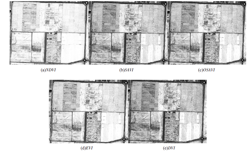
| 植被指数 | 计算公式 | 参考文献 |
|---|---|---|
| NDVI | (ρNIR-ρR)/(ρNIR+ρR) | Rouse等[ |
| DVI | (ρNIR-ρR) | Jordan [ |
| SAVI | (1+0.5)(ρNIR-ρR)/(ρNIR+ρR+0.5) | Huete [ |
| OSAVI | (1+0.16)(ρNIR-ρR)/(ρNIR+ρR+0.16) | Jordan等[ |
| EVI | 2.5(ρNIR-ρR)/(ρNIR+0.6ρB+1) | Huete等[ |
| 植被指数 | 计算公式 | 参考文献 |
|---|---|---|
| NDVI | (ρNIR-ρR)/(ρNIR+ρR) | Rouse等[ |
| DVI | (ρNIR-ρR) | Jordan [ |
| SAVI | (1+0.5)(ρNIR-ρR)/(ρNIR+ρR+0.5) | Huete [ |
| OSAVI | (1+0.16)(ρNIR-ρR)/(ρNIR+ρR+0.16) | Jordan等[ |
| EVI | 2.5(ρNIR-ρR)/(ρNIR+0.6ρB+1) | Huete等[ |


| [1] |
Chen J M, Cihlar J. Retrieving leaf area index of boreal conier forests using LandsatTM images[J]. Remote Sensing of Environment, 1996, 55(2):153-162.
doi: 10.1016/0034-4257(95)00195-6 URL |
| [2] | 李长春, 牛庆林, 杨贵军, 等. 基于无人机数码影像的大豆育种材料叶面积指数估测[J]. 农业机械学报, 2017, 48(8):147-158. |
| [3] | 张彩霞, 付桢. 国际背景下中国大豆的生产困境分析与对策[J]. 河北经贸大学学报:综合版, 2020, 20(4):73-78. |
| [4] | 阎广建, 胡容海, 罗京辉, 等. 叶面积指数间接测量方法[J]. 遥感学报, 2016, 20(5):958-978. |
| [5] |
Alonzo M, Bookhagen B, McFadden J P, et al. Mapping urban forest leaf area index with airborne lidar using penetration metrics and allometr[J]. Remote Sensing of Environment, 2015, 162(2):141-153.
doi: 10.1016/j.rse.2015.02.025 URL |
| [6] | 贺佳, 郭燕, 王利军, 等. 基于作物生长监测诊断仪的玉米LAI监测模型研究[J]. 农业机械学报, 2019, 50(12):187-194. |
| [7] |
Liu J, Pattey E, G Jégo. Assessment of vegetation indices for regional crop green LAI estimation from Landsat images over multiple growing seasons[J]. Remote Sensing of Environment, 2012, 123:347-358.
doi: 10.1016/j.rse.2012.04.002 URL |
| [8] | 阎广建, 胡容海, 罗京辉, 等. 叶面积指数间接测量方法[J]. 遥感学报, 2016, 20(5):958-978. |
| [9] | 蒙继华, 吴炳方, 李强子. 全国农作物叶面积指数遥感估算方法[J]. 农业工程学报, 2007, 23(2):160-167. |
| [10] | 陈雪洋, 蒙继华, 杜鑫, 等. 基于环境星CCD数据的冬小麦叶面积指数遥感监测模型研究[J]. 国土资源遥感, 2010(2):55-58,62. |
| [11] | 侯学会, 王猛, 梁守真, 等. 基于GF-1数据的冬小麦不同生育期叶面积指数反演[J]. 山东农业科学, 2018, 50(11):148-153. |
| [12] |
Yue J, Yang G, Li C, et al. Estimation of Winter Wheat Above-Ground Biomass Using Unmanned Aerial Vehicle-Based Snapshot Hyperspectral Sensor and Crop Height Improved Models[J]. Remote Sensing, 2017, 9(7):708.
doi: 10.3390/rs9070708 URL |
| [13] |
Feng W, Zhang H Y, Zhang Y S, et al. Remote detection of canopy leaf nitrogen concentration in winter wheat by using water resistance vegetation indices from in-situ hyperspectral data[J]. Field Crops Research, 2016, 198:238-246.
doi: 10.1016/j.fcr.2016.08.023 URL |
| [14] | 姚雄, 余坤勇, 杨玉洁, 等. 基于随机森林模型的林地叶面积指数遥感估算[J]. 农业机械学报, 2017, 48(5):159-166. |
| [15] |
Gray J, Song C. Mapping leaf area index using spatial, spectral, and temporal information from multiple sensors[J]. Remote Sensing of Environment, 2012, 119:173-183.
doi: 10.1016/j.rse.2011.12.016 URL |
| [16] | 孙诗睿, 赵艳玲, 王亚娟, 等. 基于无人机多光谱遥感的冬小麦叶面积指数反演[J]. 中国农业大学学报, 2019, 24(11):51-58. |
| [17] | 韩文霆, 彭星硕, 张立元, 等. 基于多时相无人机遥感植被指数的夏玉米产量估算[J]. 农业机械学报, 2020, 51(1):148-155. |
| [18] | 陶惠林, 冯海宽, 杨贵军, 等. 基于无人机成像高光谱影像的冬小麦LAI估测[J]. 农业机械学报, 2020, 51(1):176-187. |
| [19] | 林卉, 梁亮, 张连蓬, 等. 基于支持向量机回归算法的小麦叶面积指数高光谱遥感反演[J]. 农业工程学报, 2013, 29(11):139-146. |
| [20] |
Yue J, Feng H, Jin X, et al. A Comparison of Crop Parameters Estimation Using Images from UAV-Mounted Snapshot Hyperspectral Sensor and High-Definition Digital Camera[J]. Remote Sensing, 2018, 10(7):1138.
doi: 10.3390/rs10071138 URL |
| [21] | 高林, 杨贵军, 王宝山, 等. 基于无人机遥感影像的大豆叶面积指数反演研究[J]. 中国生态农业学报, 2015, 23(7):868-876. |
| [22] | 张东彦, Coburn C, 赵晋陵, 等. 基于多角度成像数据的大豆冠层叶绿素密度反演[J]. 农业机械学报, 2013, 44(2):205-213. |
| [23] | Rouse J W. Monitoring vegetation systems in the Great Plains with ERTS[C]. NASA. Goddard Space Flight Center 3 d ERTS-1 Symp, 1974. |
| [24] | Jordan C F. Derivation of leaf-area index from quality of light on the forest floor[J]. Ecology. 1969: 663-666. |
| [25] |
Huete A R. A soil-adjusted vegetation index (SAVI)[J]. Remote Sensing of Environment, 1988, 25(3):295-309.
doi: 10.1016/0034-4257(88)90106-X URL |
| [26] |
Huete A, Didan K, Miura T, et al. Overview of the radiometric and biophysical performance of the MODIS vegetation indices[J]. Remote Sensing of Environment, 2002, 83(1):195-213.
doi: 10.1016/S0034-4257(02)00096-2 URL |
| [27] | 陆国政, 李长春, 杨贵军, 等. 基于成像高光谱仪的大豆叶面积指数反演研究[J]. 大豆科学, 2016, 35(4):599-608. |
| [28] | 刘佳, 王利民, 滕飞, 等. 玉米大豆轮作遥感监测技术研究[J]. 中国农学通报, 2017, 33(8):144-153. |
| [29] | 牛庆林, 冯海宽, 杨贵军, 等. 基于无人机数码影像的玉米育种材料株高和LAI监测[J]. 农业工程学报, 2018, 34(5):73-82. |
| [30] | 高林, 杨贵军, 于海洋, 等. 基于无人机高光谱遥感的冬小麦叶面积指数反演[J]. 农业工程学报, 2016, 32(22):113-120. |
| [31] | 张漫, 苗艳龙, 仇瑞承, 等. 基于车载三维激光雷达的玉米叶面积指数测量[J]. 农业机械学报, 2019, 50(6):12-21. |
| [32] | Omar V D, Zaman-Allah M A, Benhildah M, et al. A Novel Remote Sensing Approach for Prediction of Maize Yield Under Different Conditions of Nitrogen Fertilization[J]. Frontiers in Plant Science, 2016, 7. |
| [1] | SUN Yu, ZHANG Yongmei, WU Yujun. Recognition of Hemerocallis citrina Leaf Disease Based on PSO and SVM [J]. Chinese Agricultural Science Bulletin, 2022, 38(8): 135-140. |
| [2] | ZHOU Xiaohong. The Crop Yield Estimation Model Based on Multiple Regression Analysis [J]. Chinese Agricultural Science Bulletin, 2022, 38(8): 152-156. |
| [3] | SHAO Xuehua, LAI Duo, XIAO Weiqiang, HE Han, LIU Chuanhe, KUANG Shizi. The Effects of Drying Methods on Fruit Quality and Antioxidant Activity of Guava [J]. Chinese Agricultural Science Bulletin, 2022, 38(6): 134-140. |
| [4] | TIAN Yixin, GAO Fengju, CAO Pengpeng, GAO Qi. Dry Matter Accumulation and Transfer and Yield of Summer Soybean in Huang-huai-hai Region: The Response to Sowing Time [J]. Chinese Agricultural Science Bulletin, 2022, 38(6): 20-25. |
| [5] | YU Zhonghao, ZHOU Wei, LI Zhigang, LI Ziwen, JIA Juanxia, ZHOU Yaxing. Analysis and Comprehensive Evaluation of Main Traits of Soybean in Inner Mongolia from 2002 to 2021 [J]. Chinese Agricultural Science Bulletin, 2022, 38(34): 14-21. |
| [6] | HU Xinyue, SUN Qian, GULI GULI·Miedi Lihazi. Spatial-temporal Evolution of Normalized Difference Vegetation Index in Burqin County of Xinjiang in Five Years [J]. Chinese Agricultural Science Bulletin, 2022, 38(32): 6-11. |
| [7] | WANG Huanhuan, YANG Qin, PU Hongmei, HE Jin, CHENG Hua, HAN Min, ZHAO Xuechun, WANG Zhiwei, JIN Baocheng. Accuracy Analysis of Soybean Vegetation Coverage Measurement by Photo Line Transect Method [J]. Chinese Agricultural Science Bulletin, 2022, 38(32): 111-118. |
| [8] | CHEN Bin. Automatic Extraction of Individual Tree in Forest Land Based on UAV Remote Sensing Images: Taking Danxia Mountain Wetland Reserve as an Example [J]. Chinese Agricultural Science Bulletin, 2022, 38(29): 152-158. |
| [9] | ZHU Xixia, ZHENG Yuzhen, WANG Haihong, HUANG Bao, PING Xishuan, LIU Tianxue, ZHAO Xia, LI Yuzhen. Different Row Spacing and Reducing Nitrogen Application in Soybean-Maize Intercropping Under Mechanization: Effects on Crop Yield and Photosynthetic Characteristics of Soybean [J]. Chinese Agricultural Science Bulletin, 2022, 38(29): 16-21. |
| [10] | LOU Zhongshan. Phenological Change Characteristics of Stipa Grass at Flowering Stage on Alpine Grassland and Their Influencing Factors [J]. Chinese Agricultural Science Bulletin, 2022, 38(29): 129-134. |
| [11] | CUI Yanhua, ZHOU Tingting, SHEN Yuyang, CHEN Li, LIN Guocang, YANG Anpei, ZHANG Hang, LEI Junjie, LI Guangkuo, GAO Haifeng. Ultra-low Dose Spray of Small Plant Protection UAV: Control Effect on Wheat Powdery Mildew in Desert Oasis Wheat Region [J]. Chinese Agricultural Science Bulletin, 2022, 38(27): 147-150. |
| [12] | GUO Wen, DAI Xixi, MO Nan, ZHANG Yingqing, YU Chen, TIAN Jiang, GENG Zhide, LI Lu. Soybean Planting and Soybean Commodities’ Import and Export Trade Structure in ASEAN Countries [J]. Chinese Agricultural Science Bulletin, 2022, 38(23): 156-164. |
| [13] | GAO Zhongchao, SUN Lei, WANG Lihua, DU Chunying, ZHANG Liguo, ZHANG Jiuming, WANG Wei, GU Wei. Effects of Different Contents of Cd2+ in Soil on Growth and Development of Hemp and Soybean Seedlings [J]. Chinese Agricultural Science Bulletin, 2022, 38(22): 89-92. |
| [14] | SUN Xipeng, LI Qi, QIAO Yunfa, HU Zhenghua, ZHANG Xuying, LIU Yuanyuan. Warming and Drought in Hailun of Heilongjiang: Effects on Growth and Development of Soybean [J]. Chinese Agricultural Science Bulletin, 2022, 38(15): 27-33. |
| [15] | MA Wenzhou, CHEN Yanyan, WU Hongsheng, WANG Xiaoyun, SUN Qian, DING Jun, LI Yanhui, LIU Zheng, CAI Yuntong, XU Jinyi, ZHANG Jinfu, YIN Wen, ZHANG Xumei, XU Jianhua. Production of Liquid Organic Zinc Fertilizer by Reusing Zinc Ash Waste from Hot Dipped Galvanizing Plant [J]. Chinese Agricultural Science Bulletin, 2022, 38(15): 91-97. |
| Viewed | ||||||
|
Full text |
|
|||||
|
Abstract |
|
|||||