| [1] |
Ellis E C.Anthropogenic transformation of the terrestrial biosphere[J].Philosophical Transactions of the Royal Society A: Mathemati-cal, Physical and Engineering Sciences,2011,369(1938):1010-1035.
|
| [2] |
Shannon M. Sterling,Agnès Ducharne,Jan Polcher.The impact of global land-cover change on the terrestrial water cycle[J].Nature Climate Change,2013,3(4).
|
| [3] |
Jansen L J M,Bagnoli M,Focacci M.Analysis of land-cover/use change dynamics in Manica Province in Mozambique in a period of transition(1990-2004)[J].Forest Ecology and Management,2008,254(2):308-326.
doi: 10.1016/j.foreco.2007.08.017
URL
|
| [4] |
Pelorosso R,Leone A,Boccia L.Land cover and land use change in the Italian central apennines: a comparison of assessment methods[J].Applied Geography,2009,29(1):35-48.
doi: 10.1016/j.apgeog.2008.07.003
URL
|
| [5] |
刘纪远,匡文慧,张增祥,等.20世纪80年代末以来中国土地利用变化的基本特征与空间格局[J].地理学报,2014,69(1):3-14.
|
| [6] |
张俊平,李净.基于CA-Markov模型的甘州区土地利用变化预测分析[J].中国农学通报,2017,33(4):105-110.
|
| [7] |
龚文峰,王鑫鑫,曹凯华,等.基于RS和GIS五常市土地利用变化及模拟研究[J].黑龙江大学工程学报,2019,10(2):15-22.
|
| [8] |
张译,杨伯钢,王淼,等.京津冀地区林地空间变化及驱动力研究[J].测绘科学,2020,45(9):104-110.
|
| [9] |
于天,曹银贵,许婧雪.基于不同尺度的中国耕地变化驱动力研究进展[J].中国农学通报,2016,32(24):194-198.
|
| [10] |
吴翠霞,冯永忠,陶卓琳,等.白银市土地利用变化对生态系统服务价值的影响[J].中国农学通报,2020,36(11):74-81.
|
| [11] |
张杨,刘艳芳,顾渐萍,等.武汉市土地利用覆被变化与生态环境效应研究[J].地理科学,2011,31(10):1280-1285.
|
| [12] |
范树平,刘友兆,程从坤,等.快速城镇化地区土地利用演变及驱动机制——以巢湖流域为例[J].水土保持通报,2017,37(2):253-260.
|
| [13] |
张诗晓,张浚茂,张文康,等.泛珠江流域土地利用时空变化特征及驱动因子[J].应用生态学报,2020,31(2):573-580.
|
| [14] |
尹娟,柳德江,赵敏慧,等.2000—2014年抚仙湖流域土地利用动态变化研究[J].中国农学通报,2018,34(4):101-107.
|
| [15] |
韩冬锐,徐新良,李静,等.长江三角洲城市群热环境安全格局及土地利用变化影响研究[J].地球信息科学学报,2017,19(1):39-49.
doi: 10.3724/SP.J.1047.2017.00039
|
| [16] |
徐丽华,王欢欢,张结存,等.近15年来杭州市土地利用结构的时空演变[J].经济地理,2014,34(7):135-142.
|
| [17] |
罗娅,杨胜天,刘晓燕,等.黄河河口镇—潼关区间1998-2010年土地利用变化特征[J].地理学报,2014,69(1):42-53.
doi: 10.11821/dlxb201401004
|
| [18] |
陈佳楠,邓芳,乌恩图,等.浑善达克典型区域沙化土地十年遥感监测分析[J].中国农学通报,2015,31(29):227-234.
|
| [19] |
常成,刘霞,张光灿,等.蒙阴县土地利用动态与耕地变化驱动力分析[J].中国水土保持科学,2010,8(1):65-70.
|
| [20] |
马姣娇,牛安逸,徐颂军,等.基于地学信息图谱的珠海淇澳岛土地利用格局分析[J].华南师范大学学报:自然科学版,2018,50(2):77-85.
|
| [21] |
赵文玥,李阳兵,李媛媛,等.三峡库区腹地撂荒地动态演变及景观格局——以重庆市奉节县平安乡、竹园镇为例[J].水土保持通报,2018,38(3):256-262.
|
| [22] |
甘彩红,李阳兵,陈萌萌.基于坡耕地与聚落空间耦合的三峡库区腹地奉节县人地关系研究[J].地理研究,2015,34(7):1259-1269.
|
| [23] |
张佰林,高江波,高阳,等.中国山区农村土地利用转型解析[J].地理学报,2018,73(3):503-517.
doi: 10.11821/dlxb201803009
|
| [24] |
奉节县地方志办公室.奉节年鉴[R].团结出版社,2016,98.
|
| [25] |
赵阳,余新晓,贾剑波,等.红门川流域土地利用景观动态演变及驱动力分析[J].农业工程学报,2013,29(9):239-248.
|
| [26] |
陈磊,孙佳新,姜海,等.南京市土地利用结构时空格局及驱动因素[J].水土保持研究,2020,27(1):197-206.
|
| [27] |
李秋萍,陆汝成,梁宝坤,等.广西陆地边境地区土地利用信息图谱构建[J].水土保持研究,2016,23(6):210-215,2.
|
| [28] |
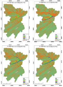
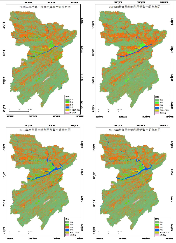
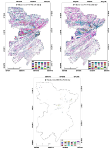
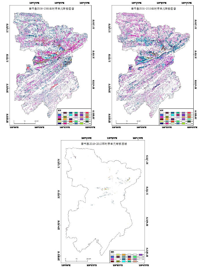
徐铖龙,龚文峰,卢玉海,等.基于土地利用信息图谱的西南区县域土地利用时空演变分析——以重庆市奉节县为例[J].黑龙江水利科技,2020,48(9):25-28.
|
| [29] |
陈菁,谢晓玲.海峡西岸快速城市化中土地利用变化的影响因素[J].经济地理,2010,30(11):1885-1889.
|
 ), 纪佩瑶2, 龚文峰2(