欢迎访问《中国农学通报》,
中国农学通报 ›› 2023, Vol. 39 ›› Issue (10): 101-112.doi: 10.11924/j.issn.1000-6850.casb2022-0276
所属专题: 农业气象
褚越1( ), 薛晓萍2, 张丽娟1(), 黄玉桃1, 汪楠1, 王楠1, 姜美伊1, 王雨萌1, 郭喜慧1, 杨艺萍1, 赵余峰1, 赵恩博1
收稿日期:2022-04-08
修回日期:2023-06-08
出版日期:2023-04-05
发布日期:2023-03-27
通讯作者:
张丽娟,女,1965年出生,河北唐山人,教授,博士,研究方向:气象灾害与生态研究。通信地址:150025 黑龙江省哈尔滨市利民经济开发区师大路1号 哈尔滨师范大学,Tel:0451-88060783,E-mail:zlj19650205@163.com。
作者简介:褚越,女,1998年出生,黑龙江鸡西人,硕士研究生,研究方向:气象灾害与生态研究。通信地址:150025 黑龙江省哈尔滨市利民经济开发区师大路1号 哈尔滨师范大学,E-mail:cy254654@163.com。
基金资助:
CHU Yue1(), XUE Xiaoping2, ZHANG Lijuan1(), HUANG Yutao1, WANG Nan1, WANG Nan1, JIANG Meiyi1, WANG Yumeng1, GUO Xihui1, YANG Yiping1, ZHAO Yufeng1, ZHAO Enbo1
Received:2022-04-08
Revised:2023-06-08
Online:2023-04-05
Published:2023-03-27
摘要:
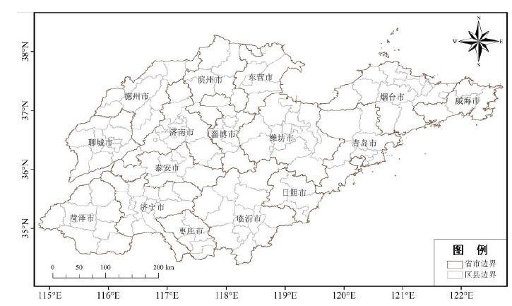
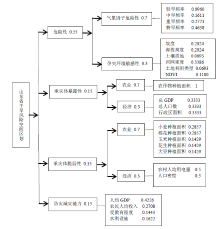
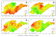
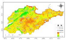
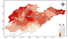
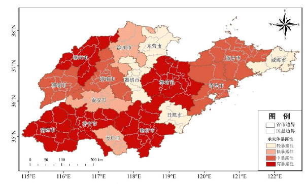
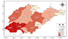
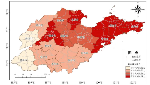
山东省作为中国的农业大省,是最重要的粮食主产区之一,受季风气候影响,是干旱灾害的易发区和重灾区,因此对山东省干旱开展灾害风险评估与区划有助于更加科学地抵御干旱灾害,对于改善山东省干旱灾害风险管理、提高决策水平、减小经济损失具有一定的指导意义。利用山东省气象、土壤、地形等基本数据以及土地利用类型、归一化植被指数等高精度数据,同时基于自然灾害风险评估原理,运用加权综合评价法和层次分析法等方法,使用GIS空间分析技术对山东省干旱灾害进行风险性评估与区划。结果表明,山东省干旱危险性较高,中、高危险性地区占总面积的59.40%,高危险性地区主要分布在山东省西北部和胶东半岛东部;承灾体暴露性偏高,中、高暴露性地区占总面积的70.66%,高暴露性地区主要分布于山东省西部和南部,中部也有部分区域暴露性较高;承灾体脆弱性略高,中、高脆弱性地区占总面积的48.1%,高脆弱性地区主要分布在山东省西南部;防灾减灾能力较强,中、高防灾减灾能力地区占总面积的50.87%,高防灾减灾能力地区主要分布在胶东半岛和北部部分区域;山东省干旱综合风险性偏高,中、高综合风险地区占总面积的54.04%,主要分布在西部和中部,东部较低。
褚越, 薛晓萍, 张丽娟, 黄玉桃, 汪楠, 王楠, 姜美伊, 王雨萌, 郭喜慧, 杨艺萍, 赵余峰, 赵恩博. 山东省干旱灾害风险评估与区划[J]. 中国农学通报, 2023, 39(10): 101-112.
CHU Yue, XUE Xiaoping, ZHANG Lijuan, HUANG Yutao, WANG Nan, WANG Nan, JIANG Meiyi, WANG Yumeng, GUO Xihui, YANG Yiping, ZHAO Yufeng, ZHAO Enbo. Risk Assessment and Zoning of Drought Disasters in Shandong Province[J]. Chinese Agricultural Science Bulletin, 2023, 39(10): 101-112.


| 地区 | 高风险性 | 中风险性 | 低风险性 | 轻风险性 | |||||||
|---|---|---|---|---|---|---|---|---|---|---|---|
| 面积/km2 | 比例/% | 面积/km2 | 比例/% | 面积/km2 | 比例/% | 面积/km2 | 比例/% | ||||
| 滨州市 | 86.7 | 0.90 | 5801.62 | 60.41 | 3664.29 | 38.15 | 51.88 | 0.54 | |||
| 德州市 | 10034.57 | 94.81 | 542.22 | 5.12 | 7.12 | 0.07 | 0 | 0 | |||
| 东营市 | 0 | 0 | 15.26 | 0.21 | 224.82 | 3.14 | 6920.64 | 96.65 | |||
| 菏泽市 | 11798.55 | 97.55 | 290.95 | 2.41 | 5.09 | 0.04 | 0 | 0 | |||
| 济南市 | 39.67 | 0.38 | 3535.09 | 33.68 | 6344.85 | 60.44 | 577.82 | 5.50 | |||
| 济宁市 | 1939.98 | 17.32 | 8405.88 | 75.06 | 839.27 | 7.49 | 13.22 | 0.12 | |||
| 聊城市 | 8092.56 | 92.50 | 656.15 | 7.50 | 0 | 0 | 0 | 0 | |||
| 临沂市 | 815.87 | 4.73 | 6700.90 | 38.85 | 9636.81 | 55.88 | 92.57 | 0.54 | |||
| 青岛市 | 0 | 0 | 107.83 | 0.96 | 10660.20 | 95.32 | 416.07 | 3.72 | |||
| 日照市 | 0 | 0 | 59.00 | 1.10 | 2461.85 | 45.90 | 2842.31 | 53.00 | |||
| 泰安市 | 21.36 | 0.27 | 5245.16 | 66.45 | 2625.63 | 33.26 | 1.02 | 0.01 | |||
| 威海市 | 0 | 0 | 50.86 | 0.90 | 5248.21 | 93.17 | 333.67 | 5.92 | |||
| 潍坊市 | 473.04 | 2.93 | 15229.88 | 94.36 | 409.97 | 2.54 | 26.45 | 0.16 | |||
| 烟台市 | 0 | 0 | 1192.27 | 8.59 | 10287.87 | 74.09 | 2404.88 | 17.32 | |||
| 枣庄市 | 0 | 0 | 62.05 | 1.36 | 3304.16 | 72.50 | 1191.25 | 26.14 | |||
| 淄博市 | 21.36 | 0.35 | 4119.02 | 67.40 | 1966.43 | 32.18 | 4.07 | 0.07 | |||


| [1] |
doi: 10.1038/nature11575 |
| [2] |
李芬, 于文金, 张建新, 等. 干旱灾害评估研究进展[J]. 地理科学进展, 2011, 30(7):891-896.
|
| [3] |
周丹, 张勃, 罗静, 等. 基于SPEI的华北地区近50年干旱发生强度的特征及成因分析[J]. 自然灾害学报, 2014, 23(4):192-202.
|
| [4] |
沙莎, 王勇, 沈新勇, 等. 基于SPEI指数的东北春旱频率变化及突变成因分析[J]. 自然灾害学报, 2017, 26(4):180-190.
|
| [5] |
倪深海, 顾颖, 彭岳津, 等. 近七十年中国干旱灾害时空格局及演变[J]. 自然灾害学报, 2019, 28(6):176-181.
|
| [6] |
doi: 10.1038/nclimate1811 |
| [7] |
doi: 10.1016/j.jhydrol.2016.01.003 URL |
| [8] |
doi: 10.1038/nature23021 URL |
| [9] |
文彦君, 方修琦, 李屹凯, 等. 华北地区1876-1879年旱灾研究文献综述[J]. 灾害学, 2019, 34(1):172-180.
|
| [10] |
赵映慧, 郭晶鹏, 毛克彪, 等. 1949—2015年中国典型自然灾害及粮食灾损特征[J]. 地理学报, 2017, 72(7):1261-1276.
doi: 10.11821/dlxb201707011 |
| [11] |
张有智, 解文欢, 吴黎, 等. 农业干旱灾害研究进展[J]. 中国农业资源与区划, 2020, 41(9):182-188.
|
| [12] |
IPCC. Climate change 2014: Mitigation of climate change[M]. United Kingdom: Cambridge University Press, 2015.
|
| [13] |
韩兰英, 张强, 程英, 等. 农业干旱灾害风险研究进展及前景分析[J]. 干旱区资源与环境, 2020, 34(6):97-102.
|
| [14] |
张继权, 李宁. 主要气象灾害风险评价与管理的数量化方法及其应用[M]. 北京: 北京师范大学出版社, 2007.
|
| [15] |
黄崇福. 自然灾害风险分析与管理[M]. 北京: 科学出版社, 2012.
|
| [16] |
张钛仁, 李茂松, 潘双迪, 等. 气象灾害风险管理[M]. 北京: 气象出版社, 2014.
|
| [17] |
梅茹玉, 毛克彪, 杜宝裕, 等. 河北省冬小麦—夏玉米干旱灾害风险评估[J]. 中国农业资源与区划, 2022(7):43.
|
| [18] |
王平. 基于地理信息系统的自然灾害区划的方法研究[J]. 北京师范大学学报(自然科学版), 2000(3):410-416.
|
| [19] |
doi: 10.1007/s11069-007-9191-5 URL |
| [20] |
doi: 10.1016/j.jher.2013.07.003 URL |
| [21] |
|
| [22] |
李万志, 张调风, 马有绚, 等. 基于灾害风险因子的青海省干旱灾害风险区划[J]. 干旱气象, 2021, 39(3):480-485,493.
|
| [23] |
李娜, 霍治国, 钱锦霞, 等. 山西省干旱灾害风险评估与区划[J]. 中国农业资源与区划, 2021, 42(5):100-107.
|
| [24] |
王理萍, 王树仿, 王新华, 等. 基于AHP和GIS的云南省干旱灾害风险区划研究[J]. 节水灌溉, 2017(10):100-103,106.
|
| [25] |
徐玉霞, 许小明, 杨宏伟, 等. 基于GIS的陕西省干旱灾害风险评估及区划[J]. 中国沙漠, 2018, 38(1):192-199.
|
| [26] |
张存杰, 王胜, 宋艳玲, 等. 我国北方地区冬小麦干旱灾害风险评估[J]. 干旱气象, 2014, 32(6):883-893.
doi: 10.11755/j.issn.1006-7639(2014)-06-0883 |
| [27] |
高操, 陈希, 张方敏, 等. 基于GIS的沧州市小麦干旱气象灾害风险评估[J]. 安徽农业科学, 2019, 47(21):223-226.
|
| [28] |
胡亚南. 华北冬小麦—夏玉米轮作区干旱灾害风险评估[D]. 北京: 中国农业科学院, 2013.
|
| [29] |
吴东丽, 王春乙, 薛红喜, 等. 华北地区冬小麦干旱风险区划. 生态学报, 2011, 31(3):760-769.
|
| [30] |
杨平, 张丽娟, 赵艳霞, 等. 黄淮海地区夏玉米干旱风险评估与区划[J]. 中国生态农业学报, 2015, 23(1):110-118.
|
| [31] |
李佳. 贵州省玉米干旱灾害风险评估[D]. 郑州: 华北水利水电大学, 2016.
|
| [32] |
单琨, 刘布春, 刘园. 基于自然灾害系统理论的辽宁省玉米干旱风险分析[J]. 农业工程学报, 2012, 28(8):186-194.
|
| [33] |
姜德娟, 李志, 王昆. 1961—2008年山东省极端降水事件的变化趋势分析[J]. 地理科学, 2011, 31(9):1118-1124.
|
| [34] |
王庆, 马倩倩, 夏艳玲, 等. 最近50年来山东地区夏季降水的时空变化及其影响因素研究[J]. 地理科学, 2014, 34(2):220-228.
doi: 10.13249/j.cnki.sgs.2014.02.220 |
| [35] |
王正东, 郭鹏, 万红, 等. 基于MODIS数据的山东省2014—2016年干旱监测分析[J]. 水土保持研究, 2019, 26(2):330-336.
|
| [36] |
李会群, 王文. 基于相对湿润度指数的山东省作物生长季干旱特征[J]. 干旱区资源与环境, 2015, 29(11):191-196.
|
| [37] |
苏喆, 廉丽姝, 刘元月, 等. 基于SPI的1960—2018年山东省冬小麦生长期干旱时空特征分析[J]. 曲阜师范大学学报(自然科学版), 2021, 47(1):99-106.
|
| [38] |
王兆雪. 基于遥感的山东省旱情监测及干旱指数适用性分析研究[D]. 青岛: 青岛大学, 2020.
|
| [39] |
杨丽. 山东省小麦玉米干旱指数保险研究[D]. 南京: 南京信息工程大学, 2013.
|
| [40] |
姜甜甜. 基于农业保险风险区划的山东省小麦干旱指数保险研究[D]. 济南: 山东财经大学, 2016.
|
| [41] |
李哲东. 山东省花生干旱指数保险定价研究[D]. 贵阳: 贵州财经大学, 2016.
|
| [42] |
童德明, 白雲, 张莎, 等. 干旱严重程度指数(DSI)在山东省干旱遥感监测中的适用性[J]. 中国农业气象, 2020, 41(2):102-112.
|
| [43] |
杜桂河, 陈燕, 杜晓惠. 山东省近几年干旱时空分布特征分析[J]. 山东水利, 2017(4):3-4.
|
| [44] |
朱秀红. 山东省干旱特征分析[A].//中国气象学会2007年年会气候学分会场论文集[C]. 2007:1121-1124.
|
| [45] |
张继权, 梁警丹, 周道玮. 基于GIS技术的吉林省生态灾害风险评价[J]. 应用生态学报, 2007(8):1765-1770.
|
| [46] |
谷亚超, 于利武, 代庆. 干旱分类及常用计算方法概述[J]. 东北水利水电, 2011, 29(5):37-39.
|
| [47] |
马蒙蒙. 近60年山东省干旱时空分布特征分析[D]. 济南: 济南大学, 2020.
|
| [48] |
童德明. 基于遥感数据的山东干旱特征分析[D]. 青岛: 青岛大学, 2020.
|
| [1] | 张秋露. 基于层次分析法的京杭运河(淮安段)外引彩叶树种综合评价[J]. 中国农学通报, 2023, 39(8): 15-20. |
| [2] | 宋宏恩, 姜常宜, 李树超, 孙兆明. 山东省种植业碳排放度量分析[J]. 中国农学通报, 2023, 39(8): 43-50. |
| [3] | 齐康康, 赵佳, 王利民, 樊阳阳, 侯学会, 阮怀军. 山东省智能农机装备重大关键技术创新战略研究[J]. 中国农学通报, 2023, 39(5): 1-5. |
| [4] | 叶佩, 刘可群, 申双和, 刘凯文, 刘志雄, 邓艳君. 湖北中稻抽穗开花期高温热害风险分析及区划[J]. 中国农学通报, 2022, 38(8): 110-117. |
| [5] | 任曙霞, 郝玲, 董京铭, 胡冬莉, 魏怡坤. 连云港市灌南县葡萄种植气象灾害分析和气候区划[J]. 中国农学通报, 2022, 38(8): 122-128. |
| [6] | 程鸿雁, 张兰英, 王凤, 杜振宇. 山东省赤松人工林土壤理化特性与综合肥力[J]. 中国农学通报, 2022, 38(23): 70-76. |
| [7] | 梁燕, 韩传明, 周继磊, 孙超, 王翠香, 李春明, 王静, 闵旭峰, 公庆党, 孟晓烨, 杨绪强. 山东核桃良种SSR指纹图谱及分子身份证的构建——基于毛细管电泳分析[J]. 中国农学通报, 2022, 38(15): 113-121. |
| [8] | 解林晓, 段艺芳, 肖超菲, 李金龙. 山东省土地利用生态-社会-经济系统耦合协调度时空演变及障碍因子分析[J]. 中国农学通报, 2022, 38(12): 61-68. |
| [9] | 倪深海, 王亨力, 刘静楠, 顾颖. 中国农业干旱灾害特征及成因分析[J]. 中国农学通报, 2022, 38(10): 106-111. |
| [10] | 徐丹丹, 吴鑫成, 郑惠娴, 周围. 芳香植物在社区康养性植物景观中的评价与应用[J]. 中国农学通报, 2022, 38(10): 70-77. |
| [11] | 陈春燕, 林正雨, 刘远利, 高文波. 成德眉资农业农村同城化发展路径探讨[J]. 中国农学通报, 2021, 37(19): 151-157. |
| [12] | 王盼, 刘亚, 周钰鸿, 王康民, 陈子林. 浙江大盘山国家级自然保护区野果资源食用开发价值评价[J]. 中国农学通报, 2020, 36(25): 26-31. |
| [13] | 吕子鹤, 丁松爽, 卢瑞琳. 中国农作物气候适宜性研究进展[J]. 中国农学通报, 2020, 36(24): 78-84. |
| [14] | 郭方其, 黑银秀, 刘君, 吴超, 叶琪明, 张智. 基于层次分析法的切花多头菊品质性状评价[J]. 中国农学通报, 2020, 36(17): 51-56. |
| [15] | 蔡忠周, 胡亚男, 金欣. 基于层次分析模型的西宁地区雷电灾害风险区划[J]. 中国农学通报, 2020, 36(15): 74-80. |
| 阅读次数 | ||||||
|
全文 |
|
|||||
|
摘要 |
|
|||||