欢迎访问《中国农学通报》,
中国农学通报 ›› 2025, Vol. 41 ›› Issue (19): 64-72.doi: 10.11924/j.issn.1000-6850.casb2024-0800
黎小勇( ), 钟军辉, 魏彦强, 王鹏年, 喻龙, 艾书涛()
收稿日期:2024-12-18
修回日期:2025-04-08
出版日期:2025-07-05
发布日期:2025-07-10
通讯作者:
作者简介:黎小勇,男,1988年出生,甘肃天水人,助理工程师,本科,主要从事土地质量调查工作。通信地址:830057 新疆乌鲁木齐市西环北路555号 中国地质调查局乌鲁木齐自然资源综合调查中心,E-mail:634075634@qq.com。
基金资助:
LI Xiaoyong(), ZHONG Junhui, WEI Yanqiang, WANG Pengnian, YU Long, AI Shutao()
Received:2024-12-18
Revised:2025-04-08
Published:2025-07-05
Online:2025-07-10
摘要:
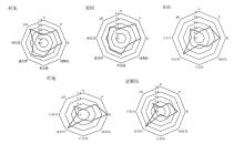
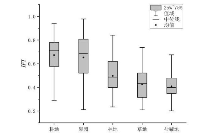
为探究典型干旱绿洲区不同土地利用类型土壤肥力状况,于地处塔里木盆地东北边缘的库铁垦区,以绿洲区耕地、果园、林地、草地和盐碱地等5种土地利用类型土壤为研究对象,测定土壤pH、全氮、全磷、全钾、碱解氮、有效磷、速效钾和有机质等指标,采用模糊综合评价方法对研究区土壤肥力进行综合评价,以期为该区域土壤资源的管理和生态恢复提供科学参考。结果显示,研究区土壤pH在7.44~9.85之间,中位数为8.16,属于弱变异(变异系数0.037),土壤以碱性或强碱性为主;土壤全磷、全钾、有效磷、速效钾处于中上水平,有机质、全氮、碱解氮处于缺乏水平;各土地利用类型的土壤肥力不同,耕地为最高,果园次之,林地、草地和盐碱地较低;果园和耕地土壤有机质、全氮、碱解氮、全磷、有效磷含量高于林地、草地和盐碱地。研究发现,库铁垦区整体土壤肥力水平不高,其中土壤碱解氮和有机质是土壤肥力主要的限制因素。
黎小勇, 钟军辉, 魏彦强, 王鹏年, 喻龙, 艾书涛. 新疆塔里木盆地东北缘绿洲不同土地利用类型土壤肥力评价[J]. 中国农学通报, 2025, 41(19): 64-72.
LI Xiaoyong, ZHONG Junhui, WEI Yanqiang, WANG Pengnian, YU Long, AI Shutao. Soil Fertility Evaluation of Different Land Use Types in Northeastern Margin of Tarim Basin in Xinjiang[J]. Chinese Agricultural Science Bulletin, 2025, 41(19): 64-72.
| 级别 | 有机质/(g/kg) | 全氮/(g/kg) | 全磷/(g/kg) | 全钾/(g/kg) | 碱解氮/(mg/kg) | 有效磷/(mg/kg) | 速效钾/(mg/kg) |
|---|---|---|---|---|---|---|---|
| 丰富 | >40 | >2 | >1 | >25 | >150 | >40 | >200 |
| 较丰富 | 30~40 | 1.5~2 | 0.8~1 | 20~25 | 120~150 | 20~40 | 150~200 |
| 中等 | 20~30 | 1~1.5 | 0.6~0.8 | 15~20 | 90~120 | 10~20 | 100~150 |
| 较缺乏 | 10~20 | 0.75~1 | 0.4~0.6 | 10~15 | 60~90 | 5~10 | 50~100 |
| 缺乏 | 6~10 | 0.5~0.75 | 0.2~0.4 | 5~10 | 30~60 | 3~5 | 30~50 |
| 极缺乏 | <6 | <0.5 | <0.2 | <5 | <30 | <3 | <30 |
| 指标 | 单位 | 函数类型 | x1 | x2 | x3 | x4 |
|---|---|---|---|---|---|---|
| pH | 无量纲 | 抛物线型 | 5 | 6.5 | 8 | 9 |
| 有机质 | g/kg | S型 | 6 | 20 | — | — |
| 全氮 | g/kg | S型 | 0.2 | 1.5 | — | — |
| 碱解氮 | mg/kg | S型 | 30 | 120 | — | — |
| 全磷 | g/kg | S型 | 0.4 | 1 | — | — |
| 有效磷 | mg/kg | S型 | 5 | 40 | — | — |
| 全钾 | g/kg | S型 | 5 | 25 | — | — |
| 速效钾 | mg/kg | S型 | 100 | 250 | — | — |
| 元素 | 养分特征 | 等级分布/% | ||||||||||
|---|---|---|---|---|---|---|---|---|---|---|---|---|
| 最小值 | 最大值 | 平均值 | 标准差 | 变异系数 | 丰富 | 较丰富 | 中等 | 较缺乏 | 缺乏 | 极缺乏 | ||
| N | 0.10 g/kg | 2.20 g/kg | 0.69 g/kg | 0.28 | 0.399 | 0.21 | 1.93 | 5.57 | 37.42 | 31.00 | 23.90 | |
| P | 0.30 g/kg | 3.17 g/kg | 0.82 g/kg | 0.22 | 0.264 | 12.07 | 44.87 | 31.12 | 11.71 | 0.23 | 0.00 | |
| K | 12.80 g/kg | 43.80 g/kg | 20.43 g/kg | 2.96 | 0.145 | 3.15 | 3.15 | 53.12 | 43.17 | 0.57 | 0.00 | |
| AN | 1.52 mg/kg | 550 mg/kg | 70.82 mg/kg | 35.81 | 0.506 | 2.99 | 4.23 | 14.78 | 38.71 | 32.49 | 6.76 | |
| AP | 0.13 mg/kg | 369 mg/kg | 35.90 mg/kg | 26.55 | 0.740 | 37.08 | 34.71 | 14.60 | 6.50 | 3.12 | 4.00 | |
| AK | 32.5 mg/kg | 1784 mg/kg | 236.24 mg/kg | 112.39 | 0.476 | 62.89 | 21.09 | 10.68 | 4.67 | 0.59 | 0.00 | |
| SOM | 1.09 g/kg | 53.60 g/kg | 13.04 g/kg | 5.714 | 0.438 | 0.34 | 1.42 | 5.65 | 64.08 | 19.26 | 9.26 | |
| pH | 7.44 | 9.85 | 8.24 | 0.305 | 0.037 | — | — | — | — | — | — | |
| 土地利用类型 | 特征值 | N/(g/kg) | P/(g/kg) | K/(g/kg) | AN/(mg/kg) | AP/(mg/kg) | AK/(mg/kg) | SOM/(g/kg) | pH |
|---|---|---|---|---|---|---|---|---|---|
| 耕地 | 平均值 | 0.70 | 0.83 | 20.4 | 72.1 | 36.34 | 229.12 | 12.85 | 8.12 |
| 标准差 | 0.18 | 0.13 | 2.04 | 28.87 | 18.47 | 68.11 | 3.77 | 0.2 | |
| 最小值 | 0.18 | 0.45 | 13.5 | 3.03 | 0.96 | 39 | 2.25 | 7.69 | |
| 最大值 | 1.6 | 1.4 | 32.7 | 472 | 132 | 812 | 31.2 | 9.85 | |
| 变异系数 | 0.26 | 0.16 | 0.10 | 0.40 | 0.51 | 0.30 | 0.29 | 0.02 | |
| 果园 | 平均值 | 0.83 | 0.93 | 21.16 | 68.2 | 46.67 | 200.44 | 15.96 | 8.4 |
| 标准差 | 0.4 | 0.34 | 4.53 | 41.26 | 39.06 | 98.05 | 8.37 | 0.36 | |
| 最小值 | 0.1 | 0.3 | 14.2 | 0 | 1.06 | 32.5 | 1.13 | 7.44 | |
| 最大值 | 2.2 | 3.17 | 43.8 | 348 | 369 | 826 | 53.6 | 9.45 | |
| 变异系数 | 0.48 | 0.37 | 0.21 | 0.60 | 0.84 | 0.49 | 0.52 | 0.04 | |
| 林地 | 平均值 | 0.47 | 0.62 | 19.97 | 83.21 | 14.54 | 413.57 | 9.3 | 8.58 |
| 标准差 | 0.23 | 0.11 | 1.97 | 66.06 | 18.35 | 293.29 | 4.97 | 0.26 | |
| 最小值 | 0.19 | 0.47 | 16.4 | 3.03 | 0.13 | 54.40 | 3.44 | 7.96 | |
| 最大值 | 1.3 | 0.95 | 26.1 | 274.00 | 84.8 | 1784 | 25.8 | 9.01 | |
| 变异系数 | 0.49 | 0.18 | 0.10 | 0.79 | 1.26 | 0.71 | 0.53 | 0.03 | |
| 草地 | 平均值 | 0.39 | 0.59 | 20.6 | 63.71 | 13.51 | 376.09 | 7.6 | 8.61 |
| 标准差 | 0.15 | 0.12 | 3.86 | 54.35 | 15.77 | 352.31 | 3.02 | 0.29 | |
| 最小值 | 0.16 | 0.41 | 15.8 | 9.16 | 1.1 | 35.7 | 2.5 | 7.89 | |
| 最大值 | 0.78 | 0.92 | 32.9 | 237 | 94.8 | 1666 | 15.8 | 9.34 | |
| 变异系数 | 0.38 | 0.20 | 0.19 | 0.85 | 1.17 | 0.94 | 0.40 | 0.03 | |
| 盐碱地 | 平均值 | 0.33 | 0.54 | 18.08 | 65.07 | 4.5 | 353.87 | 6.83 | 8.61 |
| 标准差 | 0.14 | 0.06 | 2.16 | 54.7 | 5.38 | 171.34 | 3.71 | 0.27 | |
| 最小值 | 0.12 | 0.38 | 12.8 | 0 | 0.02 | 46.5 | 1.09 | 7.49 | |
| 最大值 | 1 | 0.89 | 31.9 | 550 | 56.1 | 1062 | 20.4 | 9.65 | |
| 变异系数 | 0.42 | 0.11 | 0.12 | 0.84 | 1.20 | 0.48 | 0.54 | 0.03 |
| 土地利用方式 | 养分 | N | P | K | AN | AP | AK | SOM | pH | |||||||||
|---|---|---|---|---|---|---|---|---|---|---|---|---|---|---|---|---|---|---|
| 耕地 | N | 1 | ||||||||||||||||
| P | 0.677** | 1 | ||||||||||||||||
| K | 0.350** | 0.312** | 1 | |||||||||||||||
| AN | 0.491** | 0.370** | 0.201** | 1 | ||||||||||||||
| AP | 0.539** | 0.736** | 0.358** | 0.388** | 1 | |||||||||||||
| AK | 0.302** | 0.146** | 0.352** | 0.432** | 0.297** | 1 | ||||||||||||
| SOM | 0.942** | 0.648** | 0.351** | 0.466** | 0.551** | 0.310** | 1 | |||||||||||
| pH | -0.289** | -0.395** | 0.033 | -0.076** | -0.211** | 0.127** | -0.252** | 1 | ||||||||||
| 果园 | N | 1 | ||||||||||||||||
| P | 0.661** | 1 | ||||||||||||||||
| K | -0.546** | -0.279** | 1 | |||||||||||||||
| AN | 0.624** | 0.451** | -0.296** | 1 | ||||||||||||||
| AP | 0.479** | 0.826** | -0.112** | 0.409** | 1 | |||||||||||||
| AK | 0.512** | 0.311** | -0.313** | 0.612** | 0.251** | 1 | ||||||||||||
| SOM | 0.975** | 0.625** | -0.559** | 0.593** | 0.450** | 0.486** | 1 | |||||||||||
| pH | -0.339** | -0.356** | 0.279** | -0.353** | -0.214** | -0.394** | -0.276** | 1 | ||||||||||
| 林地 | N | 1 | ||||||||||||||||
| P | 0.489** | 1 | ||||||||||||||||
| K | 0.126 | 0.307* | 1 | |||||||||||||||
| AN | 0.186 | 0.230 | 0.133 | 1 | ||||||||||||||
| AP | 0.337* | 0.779** | 0.117 | 0.308* | 1 | |||||||||||||
| AK | 0.325* | 0.319* | 0.000 | 0.245 | 0.303* | 1 | ||||||||||||
| SOM | 0.938** | 0.295* | 0.050 | 0.206 | 0.208 | 0.397** | 1 | |||||||||||
| pH | -0.173 | 0.050 | 0.109 | -0.278* | 0.086 | 0.191 | -0.189 | 1 | ||||||||||
| 草地 | N | 1 | ||||||||||||||||
| P | 0.628** | 1 | ||||||||||||||||
| K | -0.303* | 0.057 | 1 | |||||||||||||||
| AN | 0.299* | 0.404** | -0.220 | 1 | ||||||||||||||
| AP | 0.515** | 0.759** | 0.062 | 0.324* | 1 | |||||||||||||
| AK | 0.175 | 0.177 | -0.373** | 0.771** | -0.016 | 1 | ||||||||||||
| SOM | 0.920** | 0.453** | -0.383** | 0.325* | 0.406** | 0.254 | 1 | |||||||||||
| pH | -0.580** | -0.594** | 0.215 | -0.103 | -0.447** | 0.022 | -0.418** | 1 | ||||||||||
| 盐碱地 | N | 1 | ||||||||||||||||
| P | 0.315** | 1 | ||||||||||||||||
| K | -0.189** | 0.206** | 1 | |||||||||||||||
| AN | 0.357** | 0.076 | 0.027 | 1 | ||||||||||||||
| AP | 0.375** | 0.512** | 0.043 | 0.088 | 1 | |||||||||||||
| AK | 0.577** | 0.111 | -0.141* | 0.346** | 0.095 | 1 | ||||||||||||
| SOM | 0.941** | 0.241** | -0.251** | 0.374** | 0.360** | 0.659** | 1 | |||||||||||
| pH | -0.356** | -0.030 | 0.169** | -0.372** | -0.198** | 0.005 | -0.340** | 1 | ||||||||||
| 肥力指标 | 主成分 | 公因子方差 | 权重 | ||
|---|---|---|---|---|---|
| P1 | P2 | P3 | |||
| N | 0.919 | 0.010 | -0.078 | 0.851 | 0.141 |
| P | 0.874 | -0.283 | 0.030 | 0.845 | 0.140 |
| K | -0.049 | -0.453 | 0.787 | 0.827 | 0.138 |
| AN | 0.577 | 0.534 | 0.207 | 0.660 | 0.110 |
| AP | 0.791 | -0.285 | 0.231 | 0.759 | 0.126 |
| AK | 0.162 | 0.827 | 0.314 | 0.809 | 0.134 |
| SOM | 0.895 | 0.064 | -0.057 | 0.808 | 0.134 |
| pH | -0.440 | 0.131 | 0.496 | 0.457 | 0.076 |
| 特征值 | 3.588 | 1.357 | 1.071 | — | — |
| 方差贡献率/% | 44.854 | 16.957 | 13.387 | — | — |
| 累计贡献率/% | 44.854 | 61.811 | 75.198 | — | — |

| 等级 | 耕地 | 果园 | 林地 | 草地 | 盐碱地 |
|---|---|---|---|---|---|
| 高 | 17.47 | 26.73 | 1.43 | 0.00 | 0.00 |
| 较高 | 54.06 | 38.39 | 25.71 | 7.69 | 4.17 |
| 中 | 24.27 | 21.12 | 47.14 | 51.92 | 45.08 |
| 较低 | 4.21 | 13.75 | 25.71 | 40.38 | 50.76 |
| 低 | 0.00 | 0.00 | 0.00 | 0.00 | 0.00 |
| 等级 | 耕地 | 果园 | 林地 | 草地 | 盐碱地 |
|---|---|---|---|---|---|
| 高 | 17.47 | 26.73 | 1.43 | 0.00 | 0.00 |
| 较高 | 54.06 | 38.39 | 25.71 | 7.69 | 4.17 |
| 中 | 24.27 | 21.12 | 47.14 | 51.92 | 45.08 |
| 较低 | 4.21 | 13.75 | 25.71 | 40.38 | 50.76 |
| 低 | 0.00 | 0.00 | 0.00 | 0.00 | 0.00 |
| [1] |
赖宁, 陈署晃, 付彦博, 等. 基于GIS的南疆果园土壤肥力评价[J]. 新疆农业科学, 2019, 56(8):1476-1486.
doi: 10.6048/j.issn.1001-4330.2019.08.012 |
| [2] |
虞轶俊, 马军伟, 陆若辉, 等. 有机肥对土壤特性及农产品产量和品质影响研究进展[J]. 中国农学通报, 2020, 36(35):64-71.
doi: 10.11924/j.issn.1000-6850.casb2020-0110 |
| [3] |
邓博, 郭澎, 卫磊嘉, 等. 外源添加物对不同土地利用方式下土壤肥力的影响[J]. 中国农学通报, 2024, 40(8):91-100.
doi: 10.11924/j.issn.1000-6850.casb2023-0569 |
| [4] |
|
| [5] |
宋希娟, 王克林, 刘淑娟, 等. 桂西北喀斯特地区不同土地利用方式土壤的有机碳含量及养分特征[J]. 湖南农业大学学报(自然科学版), 2013, 39(6):655-659.
|
| [6] |
李子君, 郭佳怡, 王海军. 沂蒙山区不同土地利用方式下土壤理化性质及土壤质量的差异性[J]. 陕西师范大学学报(自然科学版), 2023, 51(2):108-120.
|
| [7] |
徐莉, 闫俊杰, 陈晨, 等. 新疆察布查尔县农耕层土壤养分空间特征及其与地形因子的关系[J]. 水土保持通报, 2018, 38(4):38-45.
|
| [8] |
颜雄, 张杨珠, 刘晶. 土壤肥力质量评价的研究进展[J]. 湖南农业科学, 2008(5):82-85.
|
| [9] |
李春情, 屈用函, 农全东, 等. 基于主成分和聚类分析的云南文山典型石漠化区土壤肥力分析[J]. 中国农学通报, 2024, 40(1):66-72.
doi: 10.11924/j.issn.1000-6850.casb2023-0065 |
| [10] |
窦磊, 周永章, 王旭日, 等. 针对土壤重金属污染评价的模糊数学模型的改进及应用[J]. 土壤通报, 2007, 226(1):101-105.
|
| [11] |
段碧辉, 孙奥, 王芳, 等. 荆门市耕地不同利用方式土壤质量综合评价[J]. 土壤, 2023, 55(6):1371-1379.
|
| [12] |
陈峰, 蒋新, 唐访良, 等. 层次分析法与地理信息系统在农田土壤重金属污染评价中的应用[J]. 环境污染与防治, 2012, 34(7):6-8.
|
| [13] |
王建国, 杨林章, 单艳红, 等. 模糊数学在土壤质量评价中的应用研究[J]. 土壤学报, 2001, 38(2):176-183.
|
| [14] |
邓晓倩, 马素娟, 曹晓萍, 等. 青海省互助县10年耕地土壤养分状况、变化趋势及肥力评价[J]. 水土保持研究, 2022, 29(6):112-120.
|
| [15] |
黄加忠, 张龙, 叶雷, 等. 模糊综合评价法在南华土壤肥力评价中的应用[J]. 环境生态学, 2024, 6(10):25-32.
|
| [16] |
字春光, 钱颖颖, 倪明, 等. 云南南亚热带气候区植烟土壤养分空间分布特征及肥力评价[J]. 西南农业学报, 2024, 37(10):2252-2260.
|
| [17] |
焦润兴, 卜东升, 张涛, 等. 新疆阿拉尔植棉区土壤养分丰缺状况评价[J]. 石河子大学学报(自然科学版), 2023, 41(2):160-167.
doi: 10.13880/j.cnki.65-1174/n.2023.23.001 |
| [18] |
孙波, 张桃林, 赵其国. 我国东南丘陵山区土壤肥力的综合评价[J]. 土壤学报, 1995(4):362-369.
|
| [19] |
刘明庆, 韩笑, 杨育文, 等. 不同土地利用方式土壤肥力调查与评价:以浙江省建德市葛塘村为例[J]. 生态与农村环境学报, 2023, 39(3):394-401.
|
| [20] |
黄洲, 杨广, 苏军, 等. 水资源“三条红线”约束下玛纳斯河灌区退耕土壤质量评价[J]. 干旱区研究, 2022, 39(6):1942-1951.
doi: 10.13866/j.azr.2022.06.24 |
| [21] |
|
| [22] |
郑琦, 王海江, 吕新, 等. 新疆棉田土壤质量综合评价方法[J]. 应用生态学报, 2018, 29(4):1291-1301.
doi: 10.13287/j.1001-9332.201804.029 |
| [23] |
雷志栋, 杨诗秀, 许志荣, 等. 土壤特性空间变异性初步研究[J]. 水利学报, 1985(9):10-21.
|
| [24] |
马芊红, 张光辉, 耿韧, 等. 我国东部水蚀区坡耕地土壤质量现状分析[J]. 中国水土保持科学, 2017, 15(3):36-42.
|
| [25] |
周晓兵, 陶冶, 吴林, 等. 塔克拉玛干沙漠南缘荒漠绿洲过渡带不同土地利用影响下土壤化学计量特征[J]. 生态学报, 2019, 39(3):969-980.
|
| [26] |
李忠武, 罗霄, 黄金权, 等. 红壤丘陵区不同成土母质发育稻田土壤的肥力特性[J]. 湖南大学学报(自然科学版), 2009, 36(9):73-77.
|
| [27] |
郑琦. 新疆绿洲棉田土壤环境质量综合评价研究[D]. 石河子: 石河子大学, 2018.
|
| [28] |
刘茂. 库尔勒市香梨园土壤肥力评价与有机培肥效果研究[D]. 乌鲁木齐: 新疆农业大学, 2014.
|
| [29] |
王忠波, 董海丽, 郑文生. 秸秆还田与水氮调控对土壤养分的影响[J]. 东北农业大学学报, 2022, 53(2):20-26.
|
| [30] |
于博, 武淑敏, 邱建鑫, 等. 秸秆还田年限对春玉米土壤酶活性及肥力的影响[J]. 山东农业科学, 2023, 55(5):122-126.
|
| [31] |
张亚强, 解婷婷, 梁冠军. 降水变化下红砂凋落物分解对干旱荒漠区土壤化学计量特征的影响[J]. 草地学报, 2023, 31(5):1445-1453.
doi: 10.11733/j.issn.1007-0435.2023.05.019 |
| [32] |
张爱君, 张明普. 定位试验20年黄潮土速效磷养分的变化特征[J]. 上海交通大学学报(农业科学版), 2002(3):178-189.
|
| [33] |
刘杏兰, 高宗, 刘存寿, 等. 有机—无机肥配施的增产效应及对土壤肥力影响的定位研究[J]. 土壤学报, 1996(2):138-149.
|
| [34] |
曹婧, 陈怡平, 江瑶, 等. 陕西省农田土壤速效钾时空变化及其影响因素[J]. 水土保持学报, 2021, 35(5):296-302.
|
| [35] |
张水清, 杨莉, 黄绍敏, 等. 长期施肥下潮土速效钾含量与钾素投入水平关系[J]. 植物营养与肥料学报, 2014, 20(3):773-777.
|
| [1] | 李云溪, 查养良, 陈木兰, 缑耀武, 刘泉. 咸阳阳光玫瑰葡萄种植气候条件分析及适宜性区划[J]. 中国农学通报, 2025, 41(5): 77-83. |
| [2] | 焦绍赫, 王念磊, 林小菲, 李卓, 丁永亮, 张雄峰, 胡蓉花. 基于OPLS-DA的江西上部烤烟化学成分可用性模糊综合评价[J]. 中国农学通报, 2024, 40(34): 157-164. |
| [3] | 邓小强, 李思军, 侯建林, 朱林, 夏冰, 吴文信, 江智敏, 张仲文, 章程, 郑宏斌, 王卫民, 邓小华. 烤烟上部6片烟叶一次性采收成熟度的模糊综合评价[J]. 中国农学通报, 2024, 40(1): 118-127. |
| [4] | 刘婷燕, 王晓飞, 安树伟, 顾玲玲, 许晶, 郑尧, 徐钢春. 不同池塘经标准化改造后尾水净化效果及水质评价[J]. 中国农学通报, 2023, 39(26): 154-164. |
| [5] | 孙喜军, 邓睿, 吕爽, 高莹, 蔡苗, 缑巧红, 赵娟. 西安市农用地土壤有机质空间变异特征[J]. 中国农学通报, 2022, 38(35): 43-53. |
| [6] | 格桑顿珠. 西藏昌都市洛隆县土壤养分状况分析及肥力综合评价[J]. 中国农学通报, 2022, 38(35): 30-34. |
| [7] | 高琳, 胡晋豪, 汪志超, 林昌华, 冯慧敏. 粤北山区县域土地利用对生态服务价值的影响[J]. 中国农学通报, 2022, 38(32): 69-77. |
| [8] | 卜亚强, 张旺, 李媚竹, 罗育才, 余书奇, 彭鑫美, 谢彦瑰, 卢超, 吴福平, 谢晶. 基于模糊综合评判法的穇子糊的工艺研究[J]. 中国农学通报, 2021, 37(29): 125-131. |
| [9] | 唐健, 赵隽宇, 覃祚玉, 王会利, 覃其云, 赵泽洪. 1993—2018年广西桉树主产区土壤肥力演变特征分析[J]. 中国农学通报, 2021, 37(1): 94-99. |
| [10] | 姜德志, 程军勇, 杜洋文, 殷兴东. 鄂东大别山区油茶经济性状模糊综合评价[J]. 中国农学通报, 2020, 36(16): 42-48. |
| [11] | 吴翠霞, 冯永忠, 陶卓琳, 邱晓峄, 毛龙, 雷元奇. 白银市土地利用变化对生态系统服务价值的影响[J]. 中国农学通报, 2020, 36(11): 74-81. |
| [12] | 李自林, 赵磊峰, 陆亚春, 周文亮, 罗刚, 廖小琳, 年夫照, 范东升. 隆林县植烟土壤养分含量丰缺评价[J]. 中国农学通报, 2020, 36(10): 25-32. |
| [13] | 唐怡,韦仕川. 基于GIS和PSR模型的生态环境承载力时空差异研究--以海南省为例[J]. 中国农学通报, 2018, 34(11): 40-47. |
| [14] | 李 宁,杨春江,孙瑜旸,白露超,陈阿兰,马国良,马 琪. 青海湟水河大型底栖动物群落结构及生态系统健康评价[J]. 中国农学通报, 2017, 33(35): 141-148. |
| [15] | 郑奕,刘艳,吉春容. 环塔里木盆地非对称性增温变化及其对特色林果物候期的影响[J]. 中国农学通报, 2017, 33(31): 92-97. |
| 阅读次数 | ||||||
|
全文 |
|
|||||
|
摘要 |
|
|||||