Welcome to Chinese Agricultural Science Bulletin,
Chinese Agricultural Science Bulletin ›› 2025, Vol. 41 ›› Issue (34): 147-156.doi: 10.11924/j.issn.1000-6850.casb2025-0374
Previous Articles Next Articles
LU Xiaoning1( ), XU Dandan1, LIU Ke2(), XU Weixin1, XU Baodong3
Received:2025-05-13
Revised:2025-09-26
Online:2025-12-04
Published:2025-12-04
LU Xiaoning, XU Dandan, LIU Ke, XU Weixin, XU Baodong. Research on Inversion of 10-meter Potato Leaf Area Index in Complex Terrain Area of Southwest China[J]. Chinese Agricultural Science Bulletin, 2025, 41(34): 147-156.
Add to citation manager EndNote|Ris|BibTeX
URL: https://www.casb.org.cn/EN/10.11924/j.issn.1000-6850.casb2025-0374

| 样区 | 样方数量/个 | 地面测量时间(年-月-日) | Sentinel-2 | MODIS | |||
|---|---|---|---|---|---|---|---|
| 影像获取时间(年-月-日) | 影像切片 | 产品对应时间(年-月-日) | 轨道代号 | ||||
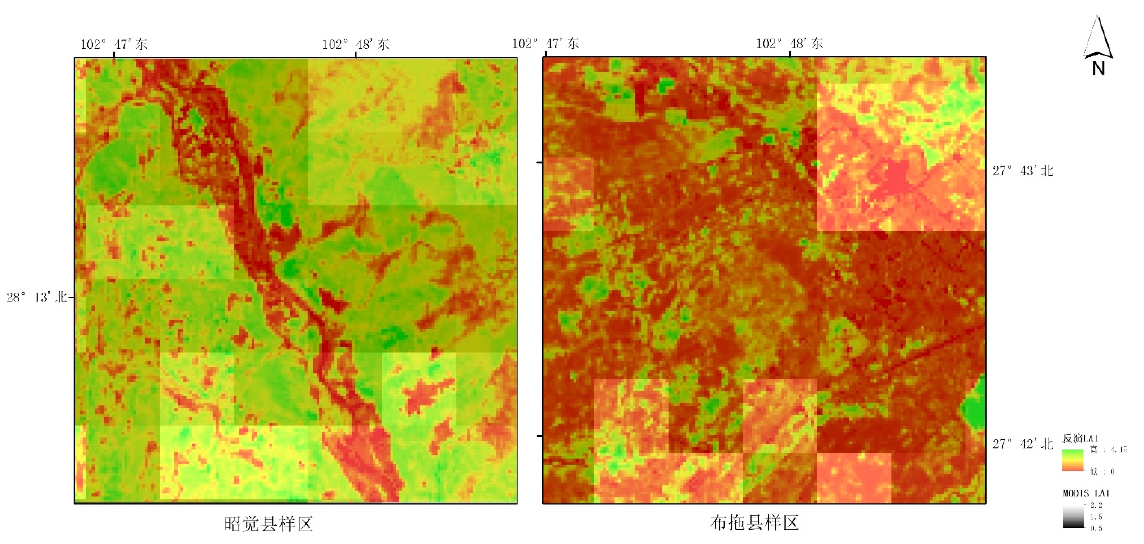
| 昭觉 | 9 | 2018-05-15 | 2018-05-15 | T48RTS | 2018-05-09—2018-05-16 | h27v06 | |
| 布拖 | 14 | 2018-05-16 | T48RTR | ||||
| 样区 | 样方数量/个 | 地面测量时间(年-月-日) | Sentinel-2 | MODIS | |||
|---|---|---|---|---|---|---|---|
| 影像获取时间(年-月-日) | 影像切片 | 产品对应时间(年-月-日) | 轨道代号 | ||||
| 昭觉 | 9 | 2018-05-15 | 2018-05-15 | T48RTS | 2018-05-09—2018-05-16 | h27v06 | |
| 布拖 | 14 | 2018-05-16 | T48RTR | ||||
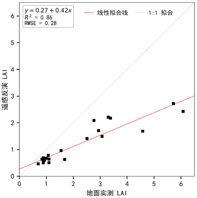

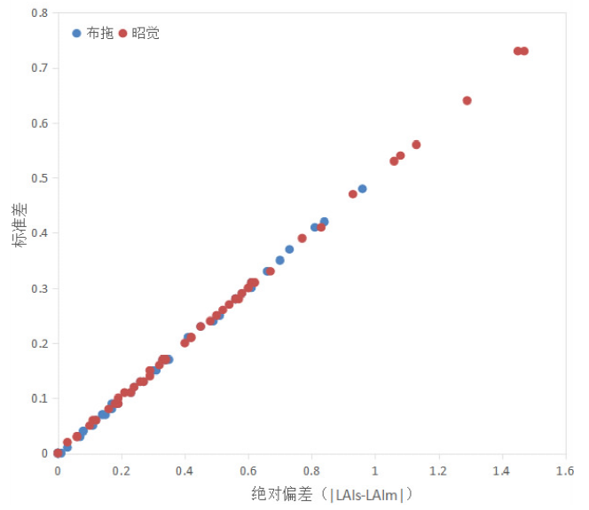
| 研究样区 | LAIm | LAIs | 标准差 | 研究样区 | LAIm | LAIs | 标准差 |
|---|---|---|---|---|---|---|---|
| 布拖 | 0.60 | 0.67 | 0.03 | 昭觉 | 1.20 | 1.38 | 0.09 |
| 1.00 | 0.92 | 0.04 | 1.20 | 1.49 | 0.15 | ||
| 1.00 | 0.27 | 0.37 | 1.20 | 0.58 | 0.31 | ||
| 0.70 | 0.36 | 0.17 | 1.20 | 1.62 | 0.21 | ||
| 1.10 | 0.65 | 0.23 | 1.40 | 1.19 | 0.11 | ||
| 0.70 | 0.46 | 0.12 | 1.60 | 0.15 | 0.73 | ||
| 0.70 | 0.14 | 0.28 | 1.60 | 1.41 | 0.09 | ||
| 0.60 | 0.19 | 0.21 | 2.20 | 1.07 | 0.56 | ||
| 0.90 | 0.29 | 0.31 | 1.20 | 1.80 | 0.30 | ||
| 布拖 | 0.60 | 1.30 | 0.35 | 昭觉 | - | 0.85 | - |
| 0.90 | 0.34 | 0.28 | 1.80 | 2.30 | 0.25 | ||
| 0.60 | 0.78 | 0.09 | 1.60 | 1.89 | 0.14 | ||
| 0.60 | 0.63 | 0.01 | 1.50 | 0.03 | 0.73 | ||
| 0.80 | 0.63 | 0.09 | 1.50 | 0.21 | 0.64 | ||
| 0.60 | 0.78 | 0.09 | 1.00 | 1.27 | 0.13 | ||
| 0.60 | 0.30 | 0.15 | 1.10 | 1.68 | 0.29 | ||
| 0.60 | 0.49 | 0.05 | 1.50 | 1.31 | 0.10 | ||
| 0.60 | 0.77 | 0.08 | 1.20 | 1.46 | 0.13 | ||
| 0.60 | 0.33 | 0.13 | 1.20 | 0.58 | 0.31 | ||
| 0.60 | 0.26 | 0.17 | 1.60 | 2.00 | 0.20 | ||
| 0.60 | 0.27 | 0.17 | 1.30 | 1.64 | 0.17 | ||
| 0.60 | 0.34 | 0.13 | 1.30 | 0.96 | 0.17 | ||
| 0.60 | 1.44 | 0.42 | 1.00 | 1.48 | 0.24 | ||
| 0.60 | 0.41 | 0.09 | 1.10 | 1.42 | 0.16 | ||
| 0.60 | 1.56 | 0.48 | 1.10 | 1.64 | 0.27 | ||
| 0.50 | 1.01 | 0.25 | 0.80 | 1.86 | 0.53 | ||
| 0.50 | 0.19 | 0.15 | 0.90 | 1.01 | 0.06 | ||
| 0.50 | 0.16 | 0.17 | 1.00 | 0.77 | 0.11 | ||
| 0.80 | 0.14 | 0.33 | 1.00 | 0.33 | 0.33 | ||
| 0.60 | 0.45 | 0.07 | 1.30 | 0.85 | 0.23 | ||
| 0.60 | 0.46 | 0.07 | 1.30 | 1.72 | 0.21 | ||
| 0.60 | 0.83 | 0.11 | 0.80 | 0.19 | 0.31 | ||
| - | 0.17 | - | 0.90 | 1.67 | 0.39 | ||
| - | 0.41 | - | 0.80 | 1.63 | 0.41 | ||
| - | 0.49 | - | 0.80 | 1.32 | 0.26 | ||
| 0.50 | 0.42 | 0.04 | 1.10 | 1.66 | 0.28 | ||
| 0.60 | 0.26 | 0.17 | 1.00 | 0.43 | 0.28 | ||
| 0.60 | 1.41 | 0.41 | 0.90 | 1.98 | 0.54 | ||
| 0.60 | 1.21 | 0.31 | 0.80 | 0.86 | 0.03 | ||
| - | 0.71 | - | 1.20 | 1.80 | 0.30 | ||
| - | 1.47 | - | 1.20 | 1.36 | 0.08 | ||
| - | 1.70 | - | 1.30 | 1.54 | 0.12 | ||
| 0.70 | 0.21 | 0.24 | 1.60 | 1.27 | 0.17 | ||
| 0.70 | 0.35 | 0.17 | 1.10 | 1.00 | 0.05 | ||
| 0.70 | 0.69 | 0.00 | 0.80 | 1.73 | 0.47 | ||
| 0.70 | 1.36 | 0.33 | 0.90 | 1.02 | 0.06 | ||
| 0.90 | 1.02 | 0.06 | 1.30 | 1.36 | 0.03 | ||
| 1.00 | 1.61 | 0.30 | 1.30 | 1.27 | 0.02 | ||
| 0.90 | 1.48 | 0.29 | 1.10 | 1.39 | 0.15 |
| [1] |
doi: 10.1111/pce.1992.15.issue-4 URL |
| [2] |
doi: 10.1029/2018RG000608 URL |
| [3] |
doi: 10.1007/s11119-019-09643-z |
| [4] |
doi: 10.1016/S0034-4257(01)00300-5 URL |
| [5] |
曾也鲁, 李静, 柳钦火. 全球LAI地面验证方法及验证数据综述[J]. 地球科学进展, 2012, 27(2):165-174.
|
| [6] |
阎广建, 胡容海, 罗京辉, 等. 叶面积指数间接测量方法[J]. 遥感学报, 2016, 20(5):958-978.
|
| [7] |
doi: 10.1016/S0034-4257(02)00075-5 URL |
| [8] |
付立哲, 屈永华, 王锦地. MODIS LAI产品真实性检验与偏差分析[J]. 遥感学报, 2017, 21(2):206-217.
|
| [9] |
doi: 10.1016/j.rse.2011.12.006 URL |
| [10] |
doi: 10.3390/rs8030263 URL |
| [11] |
吴小丹, 肖青, 闻建光, 等. 遥感数据产品真实性检验不确定性分析研究进展[J]. 遥感学报, 2014, 18(5):1011-1023.
|
| [12] |
|
| [13] |
葛玉娟, 赵宇鸾, 任红玉. 山区耕地细碎化对不同利用方式农地集约度的影响[J]. 地球科学进展, 2020, 35(2):180-188.
doi: 10.11867/j.issn.1001-8166.2020.011 |
| [14] |
王宗洪. 乡村振兴背景下凉山州马铃薯产业发展现状及对策[J]. 西昌学院学报(社会科学版), 2022, 34(4):28-31.
|
| [15] |
doi: 10.3390/rs12060912 URL |
| [16] |
doi: 10.1016/0034-4257(90)90100-Z URL |
| [17] |
doi: 10.1109/JSTARS.2023.3283535 URL |
| [18] |
doi: 10.1109/ACCESS.2021.3087411 URL |
| [19] |
苏伟, 邬佳昱, 王新盛, 等. 基于Sentinel-2影像与PROSAIL模型参数标定的玉米冠层LAI反演[J]. 光谱学与光谱分析, 2021, 41(6):1891-1897.
|
| [20] |
|
| [21] |
doi: 10.3390/rs9050405 URL |
| [22] |
doi: 10.1186/s13007-019-0534-5 |
| [23] |
doi: 10.1002/agj2.v112.4 URL |
| [24] |
|
| [25] |
|
| [26] |
doi: 10.1109/JSTARS.4609443 URL |
| [1] | ZHOU Yang, YANG Yongsen, DING Yuehua. Effects of Reducing Chemical Fertilizer and Applying Compost on Yield and Quality of Potato in Semi-arid Area of Ningxia [J]. Chinese Agricultural Science Bulletin, 2025, 41(15): 32-36. |
| [2] | LI Li, WANG Lili, LI Changjun, CHEN Xiuzhai, Tan Xiaolei, GAO Qiang, ZHANG Chao, TIAN Hongzhang. Application of Satellite Remote Sensing to Extracting Tobacco Planting Area [J]. Chinese Agricultural Science Bulletin, 2023, 39(13): 146-156. |
| [3] | Guo Jiang, Weng Qiaoyun, Song Yafei, Liu Yinghui, Yuan Jincheng. Effects of Combined Fertilization on Yield and Quality of Silage Maize [J]. Chinese Agricultural Science Bulletin, 2021, 37(27): 21-26. |
| [4] | Wang Jun, Jiang Yun. Inversion of Soybean Leaf Area Index Based on UAV Multispectral Remote Sensing [J]. Chinese Agricultural Science Bulletin, 2021, 37(19): 134-142. |
| [5] | . Effects of Planting Density on Population Physiological Indices and Yield of Sorghum [J]. Chinese Agricultural Science Bulletin, 2018, 34(8): 8-13. |
| [6] | . Dynamics of Sugar Content and Sink-source Change of Sugar Beet [J]. Chinese Agricultural Science Bulletin, 2018, 34(36): 25-30. |
| [7] | . LAI of Single Cropping Rice: The Variation Characteristics and Its Relationship with Meteorological Condition [J]. Chinese Agricultural Science Bulletin, 2018, 34(1): 1-5. |
| [8] | Li Yanda,Shu Shifu,Chen Licai,Ye Chun,Wang Kangjun and Huang Junbao. A Predict Model of Dynamic Leaf Area Index of Double Cropping Rice Based on Normalized Method [J]. Chinese Agricultural Science Bulletin, 2017, 33(29): 77-84. |
| [9] | . Effect of Different Cultivation Methods on Photosynthetic Characteristics and Yield of Maize [J]. Chinese Agricultural Science Bulletin, 2017, 33(10): 23-30. |
| [10] | 刘影 and . Research Progress of Soil Moisture Quantitative Inversion by Hyperspectral Remote Sensing [J]. Chinese Agricultural Science Bulletin, 2016, 32(7): 127-134. |
| [11] | . Sugarbeet at Different Transplanting Periods: Basic Characteristics of Dry Matter Changes [J]. Chinese Agricultural Science Bulletin, 2016, 32(27): 76-81. |
| [12] | . Seasonal Change Analysis of Leaf Area Index and Light Transmittance in Evacuation Layered Shape Canopy of‘Xinwen185’ [J]. Chinese Agricultural Science Bulletin, 2016, 32(25): 10-15. |
| [13] | Liu Yang,Yi Xiaofeng,Luo Qiyou,Gao Mingjie and Zhang Meng. Analysis of Potato Trade and Marketing Strategy in China [J]. Chinese Agricultural Science Bulletin, 2016, 32(2): 180-185. |
| [14] | Liu Ming,Feng Rui,Ji Ruipeng,Wu Jinwen,Wang Hongbo and Yu Wenying. Estimation of Leaf Area Index and Aboveground Biomass of Spring Maize by MODIS-NDVI [J]. Chinese Agricultural Science Bulletin, 2015, 31(6): 80-87. |
| [15] | . Variation characteristics and Simulation of rain-fed maize farmland soil moisture in the Western of Liaoning [J]. Chinese Agricultural Science Bulletin, 2015, 31(5): 164-170. |
| Viewed | ||||||
|
Full text |
|
|||||
|
Abstract |
|
|||||