Welcome to Chinese Agricultural Science Bulletin,
Chinese Agricultural Science Bulletin ›› 2023, Vol. 39 ›› Issue (13): 146-156.doi: 10.11924/j.issn.1000-6850.casb2022-0606
Previous Articles Next Articles
LI Li1,2( ), WANG Lili3, LI Changjun4, CHEN Xiuzhai3(), Tan Xiaolei3, GAO Qiang3, ZHANG Chao3, TIAN Hongzhang3
Received:2022-07-21
Revised:2023-01-09
Online:2023-05-05
Published:2023-04-27
LI Li, WANG Lili, LI Changjun, CHEN Xiuzhai, Tan Xiaolei, GAO Qiang, ZHANG Chao, TIAN Hongzhang. Application of Satellite Remote Sensing to Extracting Tobacco Planting Area[J]. Chinese Agricultural Science Bulletin, 2023, 39(13): 146-156.
Add to citation manager EndNote|Ris|BibTeX
URL: https://www.casb.org.cn/EN/10.11924/j.issn.1000-6850.casb2022-0606


| 波段 | 重要性 | 波段 | 重要性 | 波段 | 重要性 |
|---|---|---|---|---|---|
| B1 | 728.5 | B8 | 493.6 | NDBI | 489.6 |
| B2 | 625.4 | B9 | 342.4 | NDVI | 416.1 |
| B3 | 527.6 | B10 | 768.0 | NDWI | 449.1 |
| B4 | 530.9 | B11 | 904.8 | RVI | 424.4 |
| B5 | 533.6 | DVI | 516.8 | SAVI | 453.1 |
| B6 | 546.3 | EVI | 438.9 | VH | 448.3 |
| B7 | 602.0 | IBI | 511.1 | VV | 427.7 |
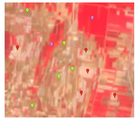
| 编号 | 经度/°E | 纬度/°N | 类型 | 现场图 | 遥感图 | |||
|---|---|---|---|---|---|---|---|---|
| 1 | 118.032652 | 35.190424 | 烟田 | | | |||
| 2 | 118.032601 | 35.190418 | 烟/谷交汇 | | | |||
| 3 | 118.031265 | 35.190522 | 玉米 | | | |||
| 4 | 118.031209 | 35.190516 | 烟/玉米交汇 | | | |||
| 5 | 118.032615 | 35.189788 | 花生 | | | |||
| 6 | 118.032637 | 35.189808 | 烟/花生交汇 | | | |||
| 7 | 118.013581 | 35.188771 | 谷地 | | | |||
| 8 | 118.046182 | 35.130072 | 烟/棉花交汇 | | | |||
| 9 | 118.046178 | 35.129995 | 棉花 | | | |||


| 乡镇 | 实际测量面积/hm2 | Sentinel-2A烟田面积监测/hm2 | 精度百分比/% |
|---|---|---|---|
| 兰山 | 0 | 0 | 100 |
| 罗庄 | 0 | 0 | 100 |
| 河东 | 0 | 0 | 100 |
| 沂南 | 953.3 | 1033.3 | 92.3 |
| 郯城 | 173.3 | 206.7 | 83.8 |
| 沂水 | 2766.7 | 2400 | 86.7 |
| 兰陵 | 1226.7 | 1253.3 | 97.9 |
| 费县 | 1753.3 | 1546.7 | 88.2 |
| 平邑 | 833.3 | 806.7 | 96.8 |
| 莒南 | 513.3 | 533.3 | 96.2 |
| 蒙阴 | 993.3 | 1020 | 97.4 |
| 临沭 | 213.3 | 253.3 | 84.2 |
| [1] |
张悦琦, 李荣平, 穆西晗, 等. 基于多时相GF-6遥感影像的水稻种植面积提取[J]. 农业工程学报, 2021, 37(17):189-196.
|
| [2] |
吕大树, 陈小龙, 藏照阳, 等. 贵州省烤烟上部烟叶成熟期主要气象因素分析[J]. 烟草科技, 2021, 54(8):18-25.
|
| [3] |
秦海超, 骆焕成, 王笑. 基于GEE和Sentinel-2影像的临沂市土地利用/覆被分类信息提取[J]. 工程勘察, 2021, 49(8):69-73.
|
| [4] |
李莉, 郭斌, 梁艳. 基于Landsat遥感影像资料的新疆阿尔泰山圆叶桦的空间变化特征[J]. 干旱气象, 2019, 37(3):439-446.
|
| [5] |
周珂, 柳乐, 张俨娜, 等. GEE支持下的河南省冬小麦面积提取及长势监测[J]. 中国农业科学, 2021, 54(11):2302-2318.
doi: 10.3864/j.issn.0578-1752.2021.11.005 |
| [6] |
陈彦四, 黄春林, 侯金亮, 等. 基于多时相Sentinel-2影像的黑河中游玉米种植面积提取研究[J]. 遥感技术与应用, 2021, 36(2):324-331.
|
| [7] |
董梅, 苏建东, 刘广玉, 等. 面向对象的无人机遥感影像烟草种植面提取和监测[J]. 测绘科学, 2014, 39(9):87-90.
|
| [8] |
赵宇虹. 随机森林遥感信息提取研究进展及应用研究[J]. 测绘与空间地理信息, 2021, 44(3):133-136,139.
|
| [9] |
赵静, 潘方江, 兰玉彬, 等. 无人机可见光遥感和特征融合的小麦倒伏面积提取[J]. 农业工程学报, 2021, 37(3):73-80.
|
| [10] |
谢鑫昌, 杨云川, 田忆, 等. 基于遥感的广西甘蔗种植面积提取及长势监测[J]. 中国生态农业学报(中英文), 2021, 29(2):410-422.
|
| [11] |
夏炎, 黄亮, 王枭轩, 等. 基于无人机影像的烟草精细提取[J]. 遥感技术与应用, 2020, 35(5):1158-1166.
|
| [12] |
张阳, 屠乃美, 陈舜尧, 等. 基于Sentinel-2A数据的县域烤烟种植面积提取分析[J]. 烟草科技, 2020, 53(11):15-22.
|
| [13] |
苏建东, 刘广玉, 杨举田, 等. 多时相无人机影像的烟草轮作精细监测[J]. 测绘科学, 2015, 40(5):71-73.
|
| [14] |
黄初龙. 基于GIS的烤烟气候适宜性分析及精细化区划——以寻甸县为例[J]. 农业与技术, 2020, 40(2):136-141.
|
| [15] |
秦泉, 王冰, 李峰, 等. 面向对象的GF-1卫星影像苹果树种植面积遥感提取研究——以山地丘陵地区的栖霞市为例[J]. 沙漠与绿洲气象, 2020, 14(2):129-136.
|
| [16] |
于利峰, 乌兰吐雅, 乌云德吉, 等. 基于纹理特征与MODIS-NDVI时间序列的耕地面积提取研究[J]. 中国农业资源与区划, 2018, 39(11):169-177.
|
| [17] |
陶健, 申国明, 徐宜民, 等. 遥感在烟草种植监测及管理中的应用展望[J]. 中国烟草学报, 2015, 21(2):111-116.
|
| [18] |
史婷婷, 张小波, 张珂, 等. 基于多源多时相遥感影像的宁国前胡种植面积提取研究[J]. 中国中药杂志, 2017, 42(22):4362-4367.
|
| [19] |
黄健熙, 侯矞焯, 苏伟, 等. 基于GF-1WFV数据的玉米与大豆种植面积提取方法[J]. 农业工程学报, 2017, 33(7):164-170.
|
| [20] |
薛宇飞, 张军, 张萍, 等. 基于Sentinel-2遥感影像的烟草种植信息精准提取[J]. 中国烟草科学, 2022, 43(1):96-106.
|
| [21] |
周忠发, 李波, 贾龙浩. 合成孔径雷达技术在喀斯特山区烟草种植定量监测应用探讨[J]. 测绘通报, 2012(S1):246-248.
|
| [22] |
牟昱璇, 邬明权, 牛铮, 等. 南方地区复杂条件下的耕地面积遥感提取方法[J]. 遥感技术与应用, 2020, 35(5):1127-1135.
|
| [23] |
刘冰洋, 张小全, 张鋆鋆, 等. 气象因子对高香气烤烟品种主要香味前体物含量的影响[J]. 中国生态农业学报, 2016, 24(9):1214-1222.
|
| [24] |
王连喜, 徐胜男, 李琪, 等. 基于决策树和混合像元分解的江苏省冬小麦种植面积提取[J]. 农业工程学报, 2016, 32(5):182-187.
|
| [25] |
张猛, 曾永年. 基于多时相Landsat数据融合的洞庭湖区水稻面积提取[J]. 农业工程学报, 2015, 31(13):178-185.
|
| [26] |
苏伟, 姜方方, 朱德海, 等. 基于决策树和混合像元分解的玉米种植面积提取方法[J]. 农业机械学报, 2015, 46(9):289-295,301.
|
| [1] | LV Yiying, CAI Yongzhan, BAI Tao, HAN Xiaonv, LIU Dongmei, LI Zhu’an, WANG Ruibao, CHEN Xiaolong, WANG Qiyu, LIN Dengzhi, YU Lei, HUANG Feiyan. Biological Characteristics and Laboratory Virulence Determination of Tobacco Black Shank Bacteria in Qujing City [J]. Chinese Agricultural Science Bulletin, 2023, 39(7): 102-110. |
| [2] | ZHONG Junwen, WANG Zhenghao, MA Lijuan, SHI Xiangdong, DING Songshuang. Research Progress of Air-curing Tobacco Modulation [J]. Chinese Agricultural Science Bulletin, 2023, 39(7): 146-152. |
| [3] | DU Caiyan, WU Di, LI Jiakui, BAI Jiyuan, DAI Kuai, LI Jiarui, HE Yuhua, LI Jiangzhou. Nitrogen Application Rate Affects Soil Nitrogen and Phosphorus Loss and Tobacco Nitrogen Utilization in the Fuxian Lake Basin [J]. Chinese Agricultural Science Bulletin, 2023, 39(3): 80-87. |
| [4] | CHEN Zhenlu, PAN Xiaoying, LU Yusheng, HUANG Zhenrui, GU Wenjie, GUO Junjie, WEI Bin, ZENG Yuling, LIU Yixuan, HE Jingwei, LI Jiqin. Effects of Organic-inorganic Compound Conditioner on Acidified Soil Properties and Tobacco Yield and Quality [J]. Chinese Agricultural Science Bulletin, 2023, 39(3): 28-34. |
| [5] | ZONG Zhaoqi, CAO Shoutao, WU Xiuzhe, LIU Zhiguo, ZHANG Nan, CHEN Xiuzhai, LIU Peng, YANG Mingfeng. Enhancing Tobacco Resistance to Abiotic Stress by Exogenous Substances: Research Progress [J]. Chinese Agricultural Science Bulletin, 2023, 39(10): 9-16. |
| [6] | HUANG Hao, XIE Jin, YUAN Wenbin, WANG Chuliang, CHEN Kunhua, ZENG Fandong, LIANG Zengfa, SU Zhao, WANG Wei. Effects of Different Organic Materials on Root Characteristics and Accumulation of Nitrogen, Phosphorus and Potassium in Flue-cured Tobacco [J]. Chinese Agricultural Science Bulletin, 2022, 38(8): 51-57. |
| [7] | LI Dongxue, WANG Yiliu, HUAN Weiwei, BU Lingduo, WANG Ruizhi, LIU Hao, LU Dianjun, WANG Huoyan, CHEN Xiaoqin. Nutrient Content of Tobacco Leaves and Root Zone Soil Affected by Citrate Soluble Potassium Fertilizer in Yuxi [J]. Chinese Agricultural Science Bulletin, 2022, 38(7): 67-73. |
| [8] | GUAN Luohao, YANG Xin, LI Chao, ZHANG Yanling, ZHANG Guangfu, LI Yongliang, ZHOU Hanping, WANG Guangshan, ZHONG Shuai, DAI Huaxin. Influence of Remained Leaves on Yield and Quality of Flue-cured Tobacco in Tengchong [J]. Chinese Agricultural Science Bulletin, 2022, 38(4): 10-15. |
| [9] | HUNAG Lei, LI Yimeng, ZHONG Shuai, JIN Baofeng, GAO Jinjun, WANG Xiaoyuan, GUAN Luohao, WANG Chuliang, HUANG Wanting, LI Min. Changes of Physical and Chemical Indexes of Tobacco Leaves Sealed with Hypoxia After Unsealing [J]. Chinese Agricultural Science Bulletin, 2022, 38(4): 107-112. |
| [10] | HAN Min, YANG Pengwu, HE Yuqin, HU Xueqiong, ZHU Yong. Prediction of the Disaster Risk of Overcast and Rainy Days on Flue-cured Tobacco Planting in Yunnan [J]. Chinese Agricultural Science Bulletin, 2022, 38(4): 69-75. |
| [11] | XU Zhiqiang, LIU Huabing, ZHANG Xiaobing, ZHAO Yanping, ZHONG Yongjian, GU Chao, LI Zheng. Nitrogen Metabolism and Secondary Metabolism of Different Flue-cured Tobacco Varieties at Maturity Stage [J]. Chinese Agricultural Science Bulletin, 2022, 38(36): 42-47. |
| [12] | YAN Fangfang, KONG Chuixu, ZHANG Yingjie, MAO Min, JIAN Lianjun, WANG Rong. Biological Control of Tobacco Root-knot Nematode Disease by Penicillium purpurogenum K1 [J]. Chinese Agricultural Science Bulletin, 2022, 38(33): 103-108. |
| [13] | HOU Jianlin, LI Sijun, HE Mingyu, XIAO Hanqian, XIANG Tiejun, HUANG Jie, LI Wujin, XIAO Yansong, JIANG Zhimin, XU Junhua, DENG Xiaohua. Effects of Different Fertilization Modes on the Growth, Dry Matter Accumulation, Yield and Quality of Paddy-tobacco [J]. Chinese Agricultural Science Bulletin, 2022, 38(33): 39-43. |
| [14] | ZHANG Zhiling, LIN Haibin, WANG Xinwang, LIN Long, CHEN Xingfeng, GAO Weimin, LIN Zubin, CHEN Qingwen. The Correlation Between the Starch Content and the Appearance Quality and Sensory Quality of Fujian Flue-cured Tobacco [J]. Chinese Agricultural Science Bulletin, 2022, 38(31): 136-141. |
| [15] | WANG Yuemin, KE Yuqin, XIE Rongrong, LI Chunying, LI Wenqing. Effects of Spraying Microelement-fertilizer on Physiological Metabolism of Tobacco Plant at Mature Stage Under Localized Fertilization [J]. Chinese Agricultural Science Bulletin, 2022, 38(31): 24-30. |
| Viewed | ||||||
|
Full text |
|
|||||
|
Abstract |
|
|||||