Welcome to Chinese Agricultural Science Bulletin,
Chinese Agricultural Science Bulletin ›› 2020, Vol. 36 ›› Issue (11): 118-123.doi: 10.11924/j.issn.1000-6850.casb19010091
Special Issue: 小麦
Previous Articles Next Articles
Liu Xuegang1, Li Feng2, Guo Lina1
Received:2019-01-17
Revised:2019-08-14
Online:2020-04-15
Published:2020-04-28
CLC Number:
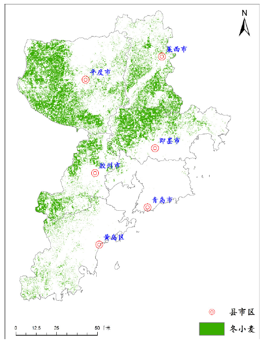
Liu Xuegang, Li Feng, Guo Lina. Winter Wheat Planting Information Extraction in Qingdao: Based on High-resolution Satellite Imagery[J]. Chinese Agricultural Science Bulletin, 2020, 36(11): 118-123.
Add to citation manager EndNote|Ris|BibTeX
URL: https://www.casb.org.cn/EN/10.11924/j.issn.1000-6850.casb19010091
| 参数 | 1 m分辨率全色/4 m分辨率多光谱相机 | |
|---|---|---|
| 光谱范围 | 全色 | 0.45~0.9 μm |
| 多光谱 | 0.45~0.52 μm | |
| 0.52~0.59 μm | ||
| 0.63~0.69 μm | ||
| 0.77~0.89 μm | ||
| 空间分辨率 | 全色 | 1 m |
| 多光谱 | 4 m | |
| 幅宽 | 45 km(2台相机组合) | |
| 重访周期(侧摆时) | 5 d | |
| 覆盖周期(不侧摆) | 69 d | |
| 参数 | 1 m分辨率全色/4 m分辨率多光谱相机 | |
|---|---|---|
| 光谱范围 | 全色 | 0.45~0.9 μm |
| 多光谱 | 0.45~0.52 μm | |
| 0.52~0.59 μm | ||
| 0.63~0.69 μm | ||
| 0.77~0.89 μm | ||
| 空间分辨率 | 全色 | 1 m |
| 多光谱 | 4 m | |
| 幅宽 | 45 km(2台相机组合) | |
| 重访周期(侧摆时) | 5 d | |
| 覆盖周期(不侧摆) | 69 d | |

| 月份 | 大蒜 | 裸地 | 水体 | 其他 |
|---|---|---|---|---|
| 11月 | 1.5651 | 1.6198 | 1.9999 | 1.9082 |
| 12月 | 1.6193 | 1.751 | 2 | 1.9446 |
| 1月 | 1.86256 | 1.8977 | 2 | 1.9711 |
| 2月 | 1.8733 | 1.9992 | 1.9999 | 1.9891 |
| 3月 | 1.9979 | 2 | 2 | 1.9991 |
| 4月 | 2 | 2 | 2 | 2 |
| 5月 | 1.9989 | 2 | 2 | 1.9889 |


| [1] | 陈仲新, 刘海启, 周清波 , 等. 全国冬小麦面积变化遥感监测抽样外推方法的研究[J]. 农业工程学报, 2000,16(5):126-129. |
| [2] | 焦险峰, 杨邦杰, 裴志远 . 基于分层抽样的中国水稻种植面积遥感调查方法研究[J]. 农业工程学报, 2006,22(5):105-110. |
| [3] | 邬明权, 杨良闯, 于博 , 等. 基于遥感与多变量概率抽样调查的作物种植面积测量[J]. 农业工程学报, 2014,30(2):146-152. |
| [4] | 马强, 闵小平, 徐晓青 . 卫星遥感技术在农业调查中的初步应用[J]. 中国农业资源与区划, 2003,24(2):14-16. |
| [5] | 陈健, 刘云慧, 宇振荣 . 基于时序MODIS-EVI数据的冬小麦种植信息提取[J]. 中国农学通报, 2011,27(1):446-450. |
| [6] | 陈仲新, 任建强, 唐华俊 , 等. 农业遥感研究应用进展与展望[J]. 遥感学报, 2016,20(5):748-767. |
| [7] | 武永利, 赵永强, 靳宁 . 单时相MERSI数据在冬小麦种植面积监测中的应用[J]. 中国农学通报, 2011,27(14):127-131. |
| [8] | 景毅刚 . 利用EOS/MODIS信息提取陕西冬小麦种植面积研究[J]. 陕西农业科学, 2008,54(2):95-98. |
| [9] | 田海峰, 王力, 牛铮 , 等. 基于新遥感数据源的县域冬小麦种植面积提取[J]. 中国农学通报, 2015,31(5):220-227. |
| [10] | 李丹, 韩留生, 黄思宇 , 等. 基于HJ-1数据的冬小麦种植面积、长势与收割进度遥感监测[J]. 中国农学通报, 2016,32(12):20-28. |
| [11] | 黄振国, 杨君 . 高分一号卫星影像监测水稻种植面积研究综述[J].湖南农业科学,2014(13):76-78. |
| [12] | 黄健熙, 贾世灵, 武洪峰 , 等. 基于GF-1WFV影像的作物面积提取方法研究[J]. 农业机械学报, 2015,46(S1):253-259. |
| [13] | 刘国栋, 邬明权, 牛铮 , 等. 基于GF-1卫星数据的农作物种植面积遥感抽样调查方法[J]. 农业工程学报, 2015,31(5):160-166. |
| [14] | 马尚杰, 易湘生, 游炯 , 等. 基于GF-1影像的冬小麦种植面积核算及直补政策实施评价[J]. 农业工程学报, 2016,32(18):169-174. |
| [15] | 王利民, 刘佳, 杨福刚 , 等. 基于GF-1卫星遥感的冬小麦面积早期识别[J]. 农业工程学报, 2015,31(11):194-201. |
| [16] | 王利民, 刘佳, 杨福刚 , 等. 基于GF-1卫星遥感数据识别京津冀冬小麦面积[J]. 作物学报, 2018,44(5):762-773. |
| [17] | 贺鹏, 徐新刚, 张宝雷 , 等. 基于多时相GF-1遥感影像的作物分类提取[J]. 河南农业科学, 2016,45(1):152-159. |
| [18] | 李峰, 谢磊, 王昊 , 等. 基于GF-1影像的冬小麦面积提取及年际变化动态监测[J]. 山东农业学报, 2017,49(8):139-144. |
| [19] | 李杰, 谭荣建 . 基于高分1号卫星数据的农作物面积遥感测量[J]. 浙江农业科学, 2018,59(3):414-416. |
| [20] | 孙姝娟, 李民录, 王萍 , 等. 基于GF-1/WFVEVI时间序列数据的水稻种植面积提取[J]. 福建农业学报, 2018,33(6):575-580. |
| [1] | WU Zhibin, HUANG Chao, LEI Yuan, JING Feng, LIU Zhandong. Water and Fertilizer Utilization Characteristics of Winter Wheat Under Different Yield Levels [J]. Chinese Agricultural Science Bulletin, 2022, 38(8): 64-71. |
| [2] | LI Hongmei, QUAN Wenting, ZHANG Shuyu. The Impact of Climate Warming on Heat Resources Before the Turning Green Stage of Winter Wheat in Central and Northern Shaanxi Province [J]. Chinese Agricultural Science Bulletin, 2022, 38(4): 53-61. |
| [3] | LIU Qi, GAO Zhiqiang, YANG Zhenping, QIAO Yuejing. Rational Nitrogen Fertilizer Application Rates Improving the Bacterial Community Structure and Physicochemical Properties of Winter Wheat Tillage Soil [J]. Chinese Agricultural Science Bulletin, 2022, 38(30): 77-84. |
| [4] | SUN Wenyan, YIN Hongjuan, TIAN Changyu, XU Jiukai, ZHAO Bingqiang, TANG Jiwei. The Effects of Chemical Fertilizer and Pig Manure on Winter Wheat Yield and Quality [J]. Chinese Agricultural Science Bulletin, 2022, 38(3): 1-10. |
| [5] | REN Sanxue, QI Yue, TIAN Xiaoli, ZHAO Huarong. Responses of Photosynthetic Parameters and Yield of Winter Wheat at Filling Stage to Soil High Humidity and Drought Change [J]. Chinese Agricultural Science Bulletin, 2022, 38(29): 96-102. |
| [6] | WU Cuixia, XU Jiali, SONG Min, YANG Lina, ZHANG Tiantian, MA Chong. Control Efficacy of 7 Pre-emergence Herbicides Against Weeds in Winter Wheat Field [J]. Chinese Agricultural Science Bulletin, 2022, 38(21): 105-111. |
| [7] | WEN Mingxing, LI Dongsheng, CHEN Chen, GUO Rui, YAO Weicheng, SHEN Xueyi, LIU Jiajun, DENG Yao. Main Agronomic Traits of Winter Wheat in Regional Trials of the Middle and Lower Reaches of the Yangtze River Valley: Evolution in the Past Decade [J]. Chinese Agricultural Science Bulletin, 2022, 38(20): 1-5. |
| [8] | LIU Changbin, QI Zewei, MA Ru, XU Wei, ZHANG Zeyan, ZHENG Haize, XUE Jianfu. Assessment of Physical Quality of Farmland Soil on the Eastern Loess Plateau Under Different Summer Crops-Winter Wheat Farming Systems [J]. Chinese Agricultural Science Bulletin, 2022, 38(11): 30-37. |
| [9] | Fu Mengxue, Wu Mingyu, Han Bibo, Zhang Qian, Han Yanlai, Tan Jinfang, Li Peipei, Zhang Tao, Li Hui. Effects of Straw Returning and Biochar Application on Yield and Nitrogen Use Efficiency of Wheat-maize Rotation [J]. Chinese Agricultural Science Bulletin, 2021, 37(8): 89-96. |
| [10] | Wang Zhijun, Wang Bisheng, Sun Xiaolu, Xu Mengjie, Yang Xiaohui, Hou Jinjin, Fang Quanxiao. Effects of Different Drip Irrigation Schedules on Soil Moisture, Wheat Growth and Water Use at Jiaodong Semi-humid Region [J]. Chinese Agricultural Science Bulletin, 2021, 37(27): 6-15. |
| [11] | Wang Qiyao, Zhao Gengxing, Li Tao, Li Jianwei, Pan Deng, Tu Qiang. Microbial Fertilizers Application in Coastal Saline Wheat Field: The Salt-reducing Effect and the Growth Response of Winter Wheat [J]. Chinese Agricultural Science Bulletin, 2021, 37(24): 60-66. |
| [12] | Liu Weixing, Zhang Wenjie, Wang Jiarui, Ma Geng, Kang Juan, Wang Chenyang. The Effect of Density and Nitrogen Fertilizer on Wheat Yield and Nitrogen Use Efficiency of Winter Wheat [J]. Chinese Agricultural Science Bulletin, 2021, 37(22): 5-10. |
| [13] | Liu Xinyue, Liu Li, Zhang Songling, Wei Yunzong. Breeding of Nationally Approved Wheat Variety ‘Linhan 8’ with Cold Resistance, Water Saving and High Yield [J]. Chinese Agricultural Science Bulletin, 2021, 37(22): 11-16. |
| [14] | Zhao Hongfei, Pan Shiqiu, Qiao Yunfa, Gao Yaxiaoling, Miao Shujie. The Responses of Winter-wheat Yield to Elevated Temperature Varied with Soil Types [J]. Chinese Agricultural Science Bulletin, 2021, 37(2): 74-79. |
| [15] | Fan Zhen, Ding Xinhui, Zhao Dan, Sun Yu, Qi Hongyu, Jiang Yongfang, Tian Xiaofei. Effects of Maize Straw Cellulose-based Super Absorbent Polymer on Soil Water Retention Capacity and Root Growth of Wheat [J]. Chinese Agricultural Science Bulletin, 2021, 37(17): 51-57. |
| Viewed | ||||||
|
Full text |
|
|||||
|
Abstract |
|
|||||