欢迎访问《中国农学通报》,
中国农学通报 ›› 2023, Vol. 39 ›› Issue (11): 80-87.doi: 10.11924/j.issn.1000-6850.casb2022-0970
石振宇1( ), 李晓燕1(), 古丽娜尔·索尔达汗1, 邢梓涵2
收稿日期:2022-11-15
修回日期:2023-01-08
出版日期:2023-04-15
发布日期:2023-04-10
通讯作者:
李晓燕,女,1975年出生,教授,博士,主要从事资源环境遥感与GIS应用方面的研究。通信地址:130012 吉林省长春市建设街2199号 吉林大学地球科学学院,E-mail:作者简介:石振宇,女,1997年出生,内蒙古兴安盟人,硕士,主要从事土地遥感及城市化进程方面的研究。通信地址:130012 吉林省长春市建设街2199号 吉林大学地球科学学院,E-mail:shizy20@mails.jlu.edu.cn。
基金资助:
SHI Zhenyu1(), LI Xiaoyan1(), GULINAER·Suoerdahan1, XING Zihan2
Received:2022-11-15
Revised:2023-01-08
Online:2023-04-15
Published:2023-04-10
摘要:
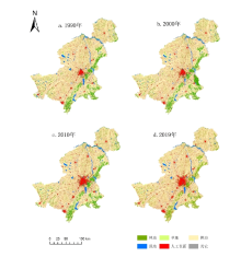
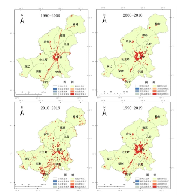
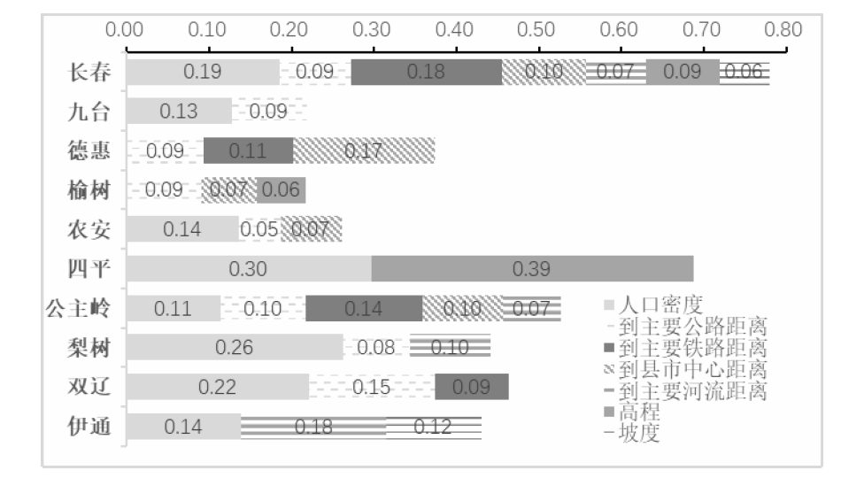
研究旨在探究建设用地扩张与耕地的时空特征以及建设用地扩张占用耕地的驱动因素。研究基于Landsat TM/OLI遥感影像数据,以吉林省中部玉米带的10个县市为研究对象,对1990、2000、2010、2019年4个时期建设用地扩张与耕地变化的时空特征及其空间驱动因素进行了分析。结果表明:(1)吉林省中部玉米带在1990—2019年间建设用地扩张了772.97 km2,建设用地扩张空间差异明显;(2)不同时间段内研究区建设用地扩张强度聚类主要为极高值聚集区,以长春市为主,建设用地扩张模型为外延型;(3)1990—2019年间研究区耕地净流失达793.19 km2,年损失率为1.01%,减少的耕地65.27%转变为建设用地,主要为城区外缘的耕地;(4)研究区建设用地扩张占用耕地的时间驱动力主要为政策因素,空间上经济区位和地理区位是主要约束因素。该研究分析了吉林省中部玉米带建设用地扩张占用耕地的时空特征,为土地利用规划提供了理论基础。
石振宇, 李晓燕, 古丽娜尔·索尔达汗, 邢梓涵. 1990—2019年吉林省中部玉米带建设用地扩张占用耕地时空特征研究[J]. 中国农学通报, 2023, 39(11): 80-87.
SHI Zhenyu, LI Xiaoyan, GULINAER·Suoerdahan, XING Zihan. Spatial-temporal Characteristics of Cultivated Land Occupied by Construction Land Expansion in Corn Belt in Central Jilin Province from 1990 to 2019[J]. Chinese Agricultural Science Bulletin, 2023, 39(11): 80-87.
| 行政区 | 建设用地扩张总面积/km2 | 填充部分 | 外延部分 | 扩张类型 | |||
|---|---|---|---|---|---|---|---|
| 面积/km2 | 比例/% | 面积/km2 | 比例/% | ||||
| 德惠 | 29.84 | 8.87 | 29.71 | 20.98 | 70.29 | 外延 | |
| 伊通 | 68.58 | 9.49 | 13.84 | 59.09 | 86.16 | 外延 | |
| 公主岭 | 112.81 | 30.21 | 26.78 | 82.60 | 73.22 | 外延 | |
| 九台 | 29.72 | 4.62 | 15.53 | 25.11 | 84.47 | 外延 | |
| 梨树 | 71.23 | 19.79 | 27.78 | 51.44 | 72.22 | 外延 | |
| 农安 | 64.65 | 14.93 | 23.09 | 49.73 | 76.91 | 外延 | |
| 双辽 | 51.73 | 14.98 | 28.96 | 36.75 | 71.04 | 外延 | |
| 四平 | 57.10 | 23.14 | 40.51 | 33.97 | 59.49 | 外延 | |
| 榆树 | 59.28 | 10.01 | 16.89 | 49.27 | 83.11 | 外延 | |
| 长春 | 379.14 | 141.25 | 37.25 | 237.89 | 62.75 | 外延 | |
| 行政区 | 耕地 | 耕地变化 | ||||||
|---|---|---|---|---|---|---|---|---|
| 2019年 | 1990年 | 2000年 | 2010年 | 1990—2000年 | 2000—2010年 | 2010—2019年 | ||
| 德惠 | 2355.32 | 2351.49 | 2345.57 | 2329.09 | -5.92 | -16.49 | 26.23 | |
| 公主岭 | 3320.56 | 3405.28 | 3429.65 | 3385.33 | 24.37 | -44.32 | -64.77 | |
| 九台 | 1954.45 | 1979.53 | 1984.78 | 1965.41 | 5.26 | -19.38 | -10.95 | |
| 梨树 | 2880.52 | 2951.42 | 2956.12 | 2919.38 | 4.69 | -36.74 | -38.86 | |
| 农安 | 4164.24 | 4187.09 | 4184.43 | 4189.41 | -2.66 | 4.98 | -25.17 | |
| 双辽 | 2298.42 | 2312.82 | 2345.14 | 2354.47 | 32.31 | 9.34 | -56.05 | |
| 四平 | 460.76 | 513.06 | 523.72 | 498.94 | 10.66 | -24.78 | -38.18 | |
| 伊通 | 1653.03 | 1727.38 | 1754.97 | 1706.16 | 27.59 | -48.81 | -53.13 | |
| 榆树 | 3693.22 | 3706.93 | 3703.04 | 3670.00 | -3.89 | -33.04 | 23.22 | |
| 长春 | 2701.30 | 3140.01 | 2823.67 | 2768.59 | -316.33 | -55.08 | -67.29 | |
| 总计 | 25481.82 | 26275.01 | 26051.09 | 25786.78 | -223.91 | -264.31 | -304.96 | |
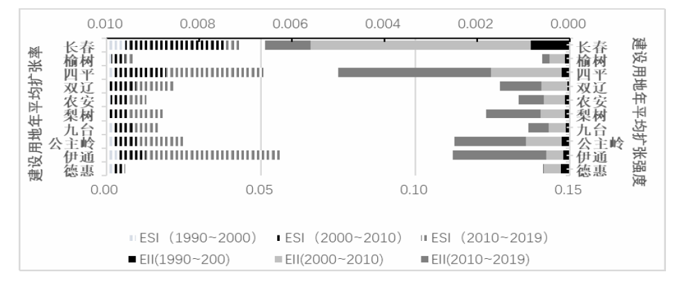
| 区域 | 建设用地扩张占用土地总量/km2 | 建设用地扩张占用耕地/km2 | 建设用地扩张占用耕地/% | ||||||||
|---|---|---|---|---|---|---|---|---|---|---|---|
| 1990—2000 | 2000—2010 | 2010—2019 | 1990—2000 | 2000—2010 | 2010—2019 | 比例 | 比例 | 比例 | |||
| 研究区 | 86.00 | 385.59 | 496.49 | 76.33 | 361.82 | 460.81 | 0.89 | 0.94 | 0.93 | ||
| 长春 | 45.90 | 226.41 | 128.42 | 41.49 | 219.68 | 119.18 | 0.90 | 0.97 | 0.93 | ||
| 九台 | 2.81 | 10.84 | 19.78 | 2.40 | 9.21 | 18.09 | 0.85 | 0.85 | 0.91 | ||
| 德惠 | 5.92 | 11.20 | 13.48 | 5.47 | 10.83 | 10.49 | 0.92 | 0.97 | 0.78 | ||
| 榆树 | 5.30 | 16.26 | 41.63 | 5.03 | 15.80 | 31.94 | 0.95 | 0.97 | 0.77 | ||
| 农安 | 6.26 | 23.98 | 39.82 | 5.28 | 17.06 | 38.63 | 0.84 | 0.71 | 0.97 | ||
| 四平 | 2.15 | 15.83 | 39.76 | 2.04 | 14.21 | 37.76 | 0.95 | 0.90 | 0.95 | ||
| 公主岭 | 7.53 | 33.11 | 74.32 | 6.55 | 31.90 | 70.83 | 0.87 | 0.96 | 0.95 | ||
| 梨树 | 4.05 | 19.36 | 49.46 | 3.57 | 19.10 | 47.93 | 0.88 | 0.99 | 0.97 | ||
| 双辽 | 2.12 | 17.09 | 33.31 | 1.05 | 14.73 | 30.22 | 0.50 | 0.86 | 0.91 | ||
| 伊通 | 3.97 | 11.50 | 56.50 | 3.44 | 9.31 | 55.73 | 0.87 | 0.81 | 0.99 | ||
| [1] |
doi: 10.1016/j.landurbplan.2011.11.006 URL |
| [2] |
李雪松. 努力实现“十四五”发展目标及2035年远景目标[J]. 经济研究参考, 2020(24):100-102.
|
| [3] |
刘永健, 耿弘, 孙文华. 城市建设用地扩张的区域差异及其驱动因素[J]. 中国人口·资源与环境, 2017, 27(8):122-127.
|
| [4] |
王旭熙, 彭立, 刘守江. 中国西南山区城市建设用地扩张特征及其驱动机制[J]. 生态学杂志, 2021, 40(9):2895-2903.
|
| [5] |
doi: 10.1016/j.landurbplan.2017.02.019 URL |
| [6] |
满卫东, 王宗明, 刘明月, 等. 1990-2013年东北地区耕地时空变化遥感分析[J]. 农业工程学报, 2016, 32(7):1-10.
|
| [7] |
赵晓丽, 张增祥, 汪潇, 等. 中国近30a耕地变化时空特征及其主要原因分析[J]. 农业工程学报, 2014, 30(3):1-11.
|
| [8] |
任晓燕, 何艳芬, 王宗明. 基于遥感的辽中南城市群建设用地扩张及其占用耕地的时空特征[J]. 国土资源遥感, 2020, 32(3):98-105.
|
| [9] |
范泽孟, 李赛博. 1990年来中国城镇建设用地占用耕地的效率和驱动机理时空分析[J]. 生态学报, 2021, 41(1):374-387.
|
| [10] |
刘涛, 史秋洁, 王雨, 等. 中国城乡建设占用耕地的时空格局及形成机制[J]. 地理研究, 2018, 37(8):1609-1623.
doi: 10.11821/dlyj201808011 |
| [11] |
谈明洪, 李秀彬, 吕昌河. 20世纪90年代中国大中城市建设用地扩张及其对耕地的占用[J]. 中国科学(D辑:地球科学), 2004(12):1157-1165.
|
| [12] |
李晓燕, 李慧颖, 满卫东, 等. 哈长城市群城镇用地扩展进程及其驱动因素研究[J]. 地理科学, 2018, 38(8):1273-1282.
doi: 10.13249/j.cnki.sgs.2018.08.009 |
| [13] |
doi: 10.1371/journal.pone.0227299 URL |
| [14] |
周烨. 城市化时空演变的多元多尺度分析及其扩张模拟预测研究[D]. 杭州: 浙江大学, 2019.
|
| [15] |
刘纪远, 王新生, 庄大方, 等. 凸壳原理用于城市用地空间扩展类型识别[J]. 地理学报, 2003(6):885-892.
|
| [16] |
李进涛, 刘彦随, 杨园园, 等. 1985-2015年京津冀地区城市建设用地时空演变特征及驱动因素研究[J]. 地理研究, 2018, 37(1):37-52.
doi: 10.11821/dlyj201801003 |
| [17] |
安柳燕, 韦燕飞, 童新华. 基于遥感的南宁市城市建设用地扩张特征及主要驱动因素研究[J]. 现代信息科技, 2022, 6(16):124-127.
|
| [18] |
叶浩, 濮励杰, 张鹏. 中国城市空间分布的省际差异及其影响因子分析[J]. 中国人口·资源与环境, 2012, 22(12):159-164.
|
| [19] |
刘彦随, 杨忍. 中国县域城镇化的空间特征与形成机理[J]. 地理学报, 2012, 67(8):1011-1020.
doi: 10.11821/xb201208001 |
| [20] |
王劲峰, 徐成东. 地理探测器:原理与展望[J]. 地理学报, 2017, 72(1):116-134.
doi: 10.11821/dlxb201701010 |
| [21] |
满卫东, 王宗明, 刘明月, 等. 1990—2013年东北地区耕地时空变化遥感分析[J]. 农业工程学报, 2016, 32(7):1-10.
|
| [22] |
王士君, 吴嫦娥. 东北城市组群整合关系及其调控机制——以长春市、吉林市为例[J]. 地理学报, 2004(S1):116-124.
|
| [23] |
叶超, 高洋. 新中国70年乡村发展与城镇化的政策演变及其态势[J]. 经济地理, 2019, 39(10):139-145.
|
| [24] |
doi: 10.1007/s11769-008-0109-2 URL |
| [25] |
doi: 10.5814/j.issn.1674-764x.2021.05.004 |
| [1] | 刘媛媛, 涂国良. 平凉市耕地土壤有效态微量元素丰缺评价及影响因素研究[J]. 中国农学通报, 2023, 39(4): 83-92. |
| [2] | 姜冰, 王松涛, 孙增兵, 张海瑞, 王建, 刘阳. 基于隶属度函数和主成分分析的耕地土壤肥力评价[J]. 中国农学通报, 2023, 39(2): 22-27. |
| [3] | 丁琪洵, 汤萌萌, 李子杰, 江文娟, 张学伟, 马友华. 涡阳县高标准农田耕地质量等级评价研究[J]. 中国农学通报, 2022, 38(4): 46-52. |
| [4] | 王延寿. 农业灌溉作用下黄土边坡失稳引起耕地流失分析[J]. 中国农学通报, 2022, 38(36): 88-93. |
| [5] | 张慧敏, 鲍广灵, 周晓天, 高琳琳, 胡宏祥, 马友华. 严格管控类耕地特定农作物重金属安全性评估[J]. 中国农学通报, 2022, 38(3): 52-58. |
| [6] | 姜玉琴, 谢先进, 黄达. 耕地质量对耕地生产力的影响[J]. 中国农学通报, 2022, 38(3): 75-80. |
| [7] | 潘雪, 蔡立群, 董博, 乜光昀. 平川区耕地质量等级及养分特征分析研究[J]. 中国农学通报, 2022, 38(29): 118-128. |
| [8] | 胡一, 王晶, 李刚. 渭北旱塬土地整治新增耕地土壤养分特征及肥力等级评价——以合阳县为例[J]. 中国农学通报, 2022, 38(27): 94-100. |
| [9] | 权胜祥, 史学峰, 刘晓月, 李昌武, 葛燚, 张燕. 可降解螯合剂强化籽粒苋修复镉污染耕地的研究[J]. 中国农学通报, 2022, 38(25): 85-89. |
| [10] | 桂苗, 汪甜甜, 马友华. 合肥市农田土壤质地空间特征分析与耕地质量提升[J]. 中国农学通报, 2022, 38(25): 114-119. |
| [11] | 邓婷, 吴家龙. 耕地土壤酸化现状及治理路径探析——以广东省为例[J]. 中国农学通报, 2022, 38(24): 70-74. |
| [12] | 骆美, 郭龙, 费坤, 张天恩, 李陈, 马友华. 耕地质量提升技术及其应用[J]. 中国农学通报, 2022, 38(21): 76-81. |
| [13] | 索龙, 王鹏, 张俊丽, 景鹏娟, 李建宏, 董晓梅, 拜翊莎, 曹红霞, 李康, 赵晓进. 陕西省畜禽粪尿养分资源及耕地负荷分析[J]. 中国农学通报, 2022, 38(20): 117-123. |
| [14] | 厉雅华, 张向前, 安祺, 武迪, 刘战勇, 孙峰, 张德健, 高敏, 张国英, 邢俊. 耕地地力评价方法及实践应用研究进展[J]. 中国农学通报, 2022, 38(15): 60-68. |
| [15] | 刘红光, 董晓翠. 长江经济带农业投入产出的能值结构、效率及其驱动因素研究[J]. 中国农学通报, 2022, 38(14): 130-138. |
| 阅读次数 | ||||||
|
全文 |
|
|||||
|
摘要 |
|
|||||