Welcome to Chinese Agricultural Science Bulletin,
Chinese Agricultural Science Bulletin ›› 2020, Vol. 36 ›› Issue (16): 101-107.doi: 10.11924/j.issn.1000-6850.casb19020078
Special Issue: 农业气象
• Research article • Previous Articles Next Articles
Qiu Yixuan1( ), Hu Yixin1,*(), Zhang Ting2, Wang Liwei3, Li Yufan1
Received:2019-02-28
Revised:2019-05-18
Online:2020-06-05
Published:2020-05-20
Contact:
Hu Yixin
E-mail:392390565@qq.com;17390553@qq.com
CLC Number:
Qiu Yixuan, Hu Yixin, Zhang Ting, Wang Liwei, Li Yufan. Frost Disaster in Jilin: The Risk Assessment and Regionalization Based on GIS[J]. Chinese Agricultural Science Bulletin, 2020, 36(16): 101-107.
Add to citation manager EndNote|Ris|BibTeX
URL: https://www.casb.org.cn/EN/10.11924/j.issn.1000-6850.casb19020078
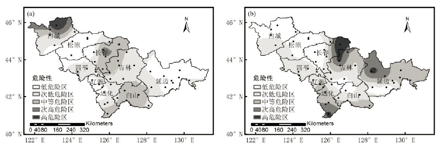
| 验证点 | 初霜冻Ih | 初霜冻Fh | 终霜冻Ih | 终霜冻Fh | |
|---|---|---|---|---|---|
| 白城 | 镇赉 | 1.000 | 0.812 | 0.000 | 0.069 |
| 通榆 | 0.000 | 0.132 | 0.176 | 0.230 | |
| 松原 | 乾安 | 0.000 | 0.119 | 0.074 | 0.119 |
| 扶余 | 0.025 | 0.091 | 0.000 | 0.063 | |
| 长春 | 九台 | 0.143 | 0.209 | 0.074 | 0.121 |
| 德惠 | 0.429 | 0.454 | 0.000 | 0.066 | |
| 四平 | 双辽 | 0.025 | 0.092 | 0.074 | 0.218 |
| 公主岭 | 0.000 | 0.111 | 0.176 | 0.260 | |
| 吉林 | 永吉 | 0.143 | 0.200 | 0.206 | 0.256 |
| 吉林 | 0.000 | 0.175 | 0.529 | 0.503 | |
| 辽源 | 辽源 | 0.000 | 0.016 | 0.000 | 0.101 |
| 东丰 | 0.000 | 0.126 | 0.176 | 0.221 | |
| 白山 | 靖宇 | 0.168 | 0.262 | 0.000 | 0.122 |
| 长白 | 0.025 | 0.156 | 0.279 | 0.303 | |
| 通化 | 通化 | 0.000 | 0.090 | 0.206 | 0.270 |
| 集安 | 0.000 | 0.292 | 0.206 | 0.444 | |
| 延边 | 敦化 | 0.000 | 0.111 | 0.588 | 0.486 |
| 珲春 | 0.143 | 0.176 | 0.412 | 0.288 | |
| [1] |
Kotikot S M, Onywere S M . Application of GIS and remote sensing techniques in frost risk mapping for mitigating agricultural losses in the Aberdare ecosystem, Kenya[J]. Geocarto International, 2015,30(1):104-121.
doi: 10.1080/10106049.2014.965758 URL |
| [2] |
Guan Y, Zheng F, Zhang P , et al. Spatial and temporal changes of meteorological disasters in China during 1950-2013[J]. Natural Hazards, 2015,75(3):2607-2623.
doi: 10.1007/s11069-014-1446-3 URL |
| [3] | 马树庆, 李锋, 王琪 . 寒潮与霜冻[M]. 北京: 气象出版社, 2009: 67-69. |
| [4] | 中国气象局气候变化中心. 2018年中国气候变化蓝皮书[M]. 北京, 2018. |
| [5] | 李洋, 王玉辉, 吕晓敏 , 等. 1961—2013年东北三省极端气候事件时空格局及变化[J]. 资源科学, 2015,37(12):2501-2513. |
| [6] | 徐风霞, 张珊, 王琪珍 , 等. 寿光1961—2015年初、终霜日、无霜期变化特征及对农业的影响[J]. 中国农学通报, 2019,35(1):112-117. |
| [7] |
Müller G V, Nuñez M N, Seluchi M E . Relationship between ENSO cycles and frost events within the Pampa Húmeda region[J]. International Journal of Climatology, 2015,20(13):1619-1637.
doi: 10.1002/(ISSN)1097-0088 URL |
| [8] |
Suzuki Y, Sato S, Kawajiri K . Frost damage and cold damage related to topographic climates in the warm region of Japan[J]. Journal of Agricultural Meteorology, 2010,37(4):289-295.
doi: 10.2480/agrmet.37.289 URL |
| [9] |
Barlow K M, Christy B P , O’Leary G J, et al. Simulating the impact of extreme heat and frost events on wheat crop production: A review[J]. Field Crops Research, 2015,171:109-119.
doi: 10.1016/j.fcr.2014.11.010 URL |
| [10] | 郑红, 魏磊, 潘华盛 , 等. 黑龙江终霜日变化特征及对粮食生产影响的分析[J]. 中国农学通报, 2016,32(11):88-94. |
| [11] | Micheloud N G, Castro D, Favaro M A , et al. Response of some Citrus species to frost damage at the central area of Santa Fe, Argentina[J]. Revista De La Facultad De Ciencias Agrarias, 2016,48(2):43-56. |
| [12] | 姚俊英, 于宏敏, 朱红蕊 , 等. 黑龙江省玉米初霜冻致灾临界气象条件风险区划[J]. 中国农学通报, 2012,28(11):312-316. |
| [13] | 朱红蕊, 刘赫男, 孙爽 , 等. 气候变暖背景下黑龙江省水稻初霜冻灾害风险区划研究[J]. 中国农学通报, 2013,29(30):29-34. |
| [14] | 王晾晾, 杨晓强, 李帅 , 等. 东北地区水稻霜冻灾害风险评估与区划[J]. 气象与环境学报, 2012,28(5):40. |
| [15] | 张黎, 尹洪涛, 张国林 . 辽宁西部地区霜冻致灾风险指数特征分析[J]. 中国农学通报, 2015,31(6):204-209. |
| [16] | 连萍, 王晾晾. 东北三省玉米霜冻灾害风险评估及区划[A].中国气象学会.沈阳第六届雨雪冰冻(霜冻)灾害论坛论文集 [C]. 2012: 26. |
| [17] | 陈凯奇, 米娜 . 辽宁省玉米低温冷害和霜冻灾害风险评估[J]. 气象与环境学报, 2016,32(1):89-94. |
| [18] | 任景全, 郭春明, 王丽伟 , 等. 1961—2015年吉林省霜时空分布特征及其影响因素[J]. 气象与环境学报, 2018,34(4):119-125. |
| [19] | 陈少勇, 郑延祥, 楼望萍 , 等. 中国西北地区初霜冻的气候变化特征[J]. 资源科学, 2013,35(1):165-172. |
| [20] | 张桂英, 姜秀萍, 周光会 , 等. 气候变暖背景下科尔沁沙地50年霜冻变化分析[J]. 中国农学通报, 2013,29(26):161-164. |
| [21] |
李芬, 张建新, 武永利 , 等. 近50年山西终霜冻的时空分布及其影响因素[J]. 地理学报, 2013,68(11):1472-1480.
doi: 10.11821/dlxb201311003 URL |
| [22] |
韩荣青, 李维京, 艾婉秀 , 等. 中国北方初霜冻日期变化及其对农业的影响[J]. 地理学报, 2010,65(5):525-532.
doi: 10.11821/xb201005002 URL |
| [23] | 吉林省统计局. 2017吉林省统计年鉴[M]. 北京: 中国统计出版社, 2017. |
| [24] | 章国材 . 气象灾害风险评估与区划方法[M]. 北京: 气象出版社, 2010. |
| [25] | 严应存, 周秉荣, 陈国茜 , 等. 1961—2010年青海省霜冻灾害变化特征及风险区划[J]. 气象科技, 2015,43(5):986-991. |
| [26] | 金志凤, 胡波, 严甲真 , 等. 浙江省茶叶农业气象灾害风险评价[J]. 生态学杂志, 2014,33(3):771-777. |
| [1] | FU Yanyan, LI Yunfeng, HAN Dong, MA Shuqing. Water Surplus and Deficit of Maize Growing Season and Its Effect on Yield in Major Grain Producing Areas of Jilin Province [J]. Chinese Agricultural Science Bulletin, 2022, 38(7): 99-105. |
| [2] | JIANG Jia, CHEN Jinpeng, WEI Jiangqiao, GUO Xuhao, CHE Zhiping, TIAN Yue’e, CHEN Genqiang, LIU Shengming. Synergistic Effect of Fludioxonil and Tebuconazole Against Fusarium graminearum [J]. Chinese Agricultural Science Bulletin, 2022, 38(6): 116-120. |
| [3] | Tsewang Thondup, DU Jun, , Phuntsok Samten. Spatial-temporal Change of Negative Accumulated Temperature in the Main Agricultural Regions of the Yarlung Zangbo River and Its Two Tributaries of Tibet During 1981-2020 [J]. Chinese Agricultural Science Bulletin, 2022, 38(5): 99-105. |
| [4] | DING Qixun, TANG Mengmeng, LI Zijie, JIANG Wenjuan, ZHANG Xuewei, MA Youhua. Cultivated Land Quality Grade Evaluation of High-standard Farmland in Guoyang County [J]. Chinese Agricultural Science Bulletin, 2022, 38(4): 46-52. |
| [5] | SUN Xijun, DENG Rui, LV Shuang, GAO Ying, CAI Miao, GOU Qiaohong, ZHAO Juan. Spatial Variability Characteristics of Farmland Soil Organic Matter in Xi'an [J]. Chinese Agricultural Science Bulletin, 2022, 38(35): 43-53. |
| [6] | LI Yunfeng, YAO Zhiping, FU Yanyan, HAN Dong, MA Shuqing. Regional Changes of Maize Drought in Jilin Province Based on the Effective Rainfall Deficit [J]. Chinese Agricultural Science Bulletin, 2022, 38(35): 62-69. |
| [7] | LU Mengyao, LIU Dehu, LU Xueli, LIANG Heng, SUN Yuanyuan, LIU Yalin, SONG Tingqiang, FAN Haisheng. Construction of Flood Disaster Risk Assessment Model Based on Principal Component Analysis in Hubei Province [J]. Chinese Agricultural Science Bulletin, 2022, 38(32): 119-127. |
| [8] | SONG Yingfang, HONG Huangxi, LI Zhuoli, CHENG Zhiyong, ZHANG Lixiang. Tea Saponin: Research Progress on Its Effect of Pest Control and Synergism [J]. Chinese Agricultural Science Bulletin, 2022, 38(31): 119-124. |
| [9] | WANG Qing, FANG Wensheng, LI Yuan, WANG Qiuxia, YAN Dongdong, CAO Aocheng. Advances in New Nematicides and Their Action Mechanism [J]. Chinese Agricultural Science Bulletin, 2022, 38(30): 100-107. |
| [10] | ZHANG Yufeng, SUN Jiangtao, LI Qingsong, FAN Liyao, WEN Qian. The Willingness and Influencing Factors of Farmers’ Homestead Exit in the Agricultural Area of Eastern Henan: An Example of Fugou County [J]. Chinese Agricultural Science Bulletin, 2022, 38(2): 150-156. |
| [11] | LI Yahua, ZHANG Xiangqian, AN Qi, WU Di, LIU Zhanyong, SUN Feng, ZHANG Dejian, GAO Min, ZHANG Guoying, XING Jun. Evaluation Methods of Cultivated Land Fertility and Their Practical Application: Research Progress [J]. Chinese Agricultural Science Bulletin, 2022, 38(15): 60-68. |
| [12] | ZHANG Jie, CHEN Meiqiu, ZHANG Shuxian, ZHANG Yuqin. The Recognition Degree of Adjustment Methods of Farmers’ Land Contract Right from the Perspective of Livelihood Capital [J]. Chinese Agricultural Science Bulletin, 2022, 38(11): 137-143. |
| [13] | Gulinaer ·Suoerdahan, LI Xiaoyan, SHI Zhenyu, XING Zihan, WU Haitao. The Impact of Construction Land Expansion on Arable Land Resources in Changchun [J]. Chinese Agricultural Science Bulletin, 2022, 38(11): 89-95. |
| [14] | Hong Li, Pang Songling, Geng Meiyun. Advances in the Practice of Urban Historical Heritage Protection and Management Based on GIS Technology [J]. Chinese Agricultural Science Bulletin, 2021, 37(8): 145-150. |
| [15] | Yan Jixuan, Kang Xia, Zhang Meihua, Sun Dongyuan, Qiao Hongqiang. Agricultural Land Transfer Behavior and Influencing Factors of Yongchang County in Hexi Corridor [J]. Chinese Agricultural Science Bulletin, 2021, 37(5): 143-148. |
| Viewed | ||||||
|
Full text |
|
|||||
|
Abstract |
|
|||||