Welcome to Chinese Agricultural Science Bulletin,
Chinese Agricultural Science Bulletin ›› 2022, Vol. 38 ›› Issue (11): 96-105.doi: 10.11924/j.issn.1000-6850.casb2021-1115
Previous Articles Next Articles
ZHANG Ying( ), YE Baojian, ZHU Zhipeng, YAO Xiong()
Received:2021-11-19
Revised:2022-02-08
Online:2022-04-15
Published:2022-05-18
Contact:
YAO Xiong
E-mail:934252021@qq.com;fjyx@fjut.edu.cn
CLC Number:
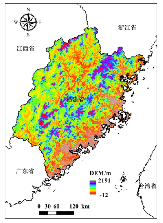
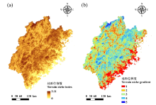
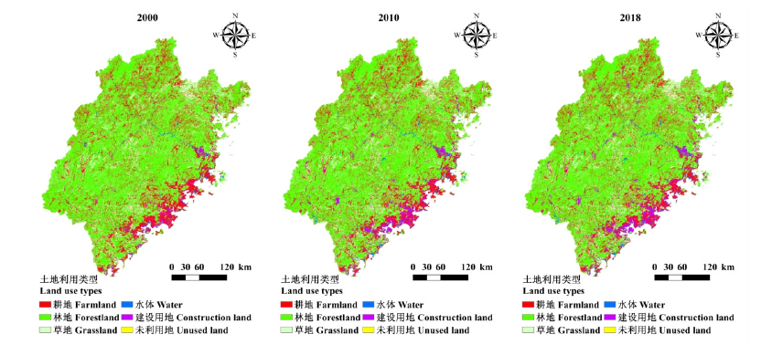
ZHANG Ying, YE Baojian, ZHU Zhipeng, YAO Xiong. Terrain Gradient Effects of Land Use Pattern in Fujian Province[J]. Chinese Agricultural Science Bulletin, 2022, 38(11): 96-105.
Add to citation manager EndNote|Ris|BibTeX
URL: https://www.casb.org.cn/EN/10.11924/j.issn.1000-6850.casb2021-1115


| 时期 | 土地利用类型 | 耕地 | 林地 | 草地 | 水体 | 建设用地 | 未利用地 |
|---|---|---|---|---|---|---|---|
| 2000—2010 | 耕地 | — | 0.88 | 0.17 | 0.6 | 4.99 | 0 |
| 林地 | 0.27 | — | 0.63 | 0.1 | 0.86 | 0.02 | |
| 草地 | 0.37 | 3.67 | — | 0.11 | 1.38 | 0.01 | |
| 水体 | 0.37 | 2.39 | 0.27 | — | 3.97 | 0.15 | |
| 建设用地 | 0.66 | 0.31 | 0.15 | 4.28 | — | 0 | |
| 未利用地 | 0.25 | 4.47 | 3.01 | 0.46 | 1.25 | — | |
| 2010—2018 | 耕地 | — | 2.98 | 0.84 | 0.15 | 2.41 | 0 |
| 林地 | 0.88 | — | 0.79 | 0.04 | 0.28 | 0 | |
| 草地 | 0.68 | 3.39 | — | 0.04 | 0.4 | 0 | |
| 水体 | 2.46 | 1.49 | 0.99 | — | 4.7 | 0.3 | |
| 建设用地 | 2.41 | 1.88 | 0.62 | 1.51 | — | 0 | |
| 未利用地 | 0.8 | 4.83 | 1.74 | 12.13 | 14.72 | — | |
| 2000—2018 | 耕地 | — | 2.84 | 0.78 | 0.65 | 6.98 | 0 |
| 林地 | 0.88 | — | 1.16 | 0.14 | 1.07 | 0.03 | |
| 草地 | 0.79 | 5.95 | — | 0.13 | 1.67 | 0.02 | |
| 水体 | 2.37 | 3.41 | 1.16 | — | 8.58 | 0.38 | |
| 建设用地 | 2.53 | 1.1 | 0.5 | 6.55 | — | 0 | |
| 未利用地 | 0.94 | 10.8 | 3.33 | 0.65 | 2.93 | — |
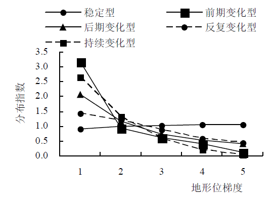
| 景观图谱 | 面积比例/% | 主要图谱类型 | 面积比例/% |
|---|---|---|---|
| 稳定型 | 93.66 | 林地-林地-林地 | 64.62 |
| 耕地-耕地-耕地 | 17.23 | ||
| 前期变化型 | 2.93 | 耕地-建设用地-建设用地 | 29.46 |
| 林地-建设用地-建设用地 | 17.04 | ||
| 后期变化型 | 2.87 | 林地-林地-耕地 | 16.10 |
| 耕地-耕地-林地 | 15.01 | ||
| 反复变化型 | 0.44 | 林地-草地-林地 | 20.28 |
| 林地-耕地-林地 | 18.97 | ||
| 持续变化型 | 0.10 | 耕地-建设用地-林地 | 10.49 |
| 草地-建设用地-林地 | 6.13 |

| [1] | 王权, 李阳兵, 刘亚香, 等. 基于地形梯度的岩溶槽谷区土地利用空间格局分析[J]. 生态学报, 2019, 39(21):7866-7880. |
| [2] | 臧玉珠, 刘彦随, 杨园园. 山区县域土地利用格局变化及其地形梯度效应--以井冈山市为例[J]. 自然资源学报, 2019, 34(7):1391-1404. |
| [3] |
EHNES R B. Land-use change affects size spectra, energy flux and ecosystem functions in litter and soil invertebrates[J]. Journal of Animal Ecology, 2019, 88:1828-1831.
doi: 10.1111/1365-2656.13144 URL |
| [4] |
GOMES L C, BIANCHI F J J A, CARDOSO I M, et al. Land use change drives the spatio-temporal variation of ecosystem services and their interactions along an altitudinal gradient in Brazil[J]. Landscape Ecology, 2020, 35:1571-1586.
doi: 10.1007/s10980-020-01037-1 URL |
| [5] | 张佰发, 苗长虹. 黄河流域土地利用时空格局演变及驱动力[J]. 资源科学, 2020, 42(3):460-473. |
| [6] | 李孝永, 匡文慧. 京津冀1980-2015年城市土地利用变化时空轨迹及未来情景模拟[J]. 经济地理, 2019, 39(3):187-194,200. |
| [7] | 陆清平, 赵翠薇, 王杰. 基于地形梯度的纯喀斯特和非喀斯特及亚喀斯特区土地利用格局分析[J]. 水土保持研究, 2021, 28(5):333-339. |
| [8] | 龚文峰, 袁力, 范文义. 基于地形梯度的哈尔滨市土地利用格局变化分析[J]. 农业工程学报, 2013, 29(2):250-259,303. |
| [9] | 赵丽红, 杨泽栋, 潘鹏, 等. 南昌市景观信息图谱的地形梯度效应分析[J]. 江西农业大学学报, 2016, 38(4):767-775. |
| [10] | 孙丕苓, 许月卿, 王数. 环京津贫困带土地利用变化的地形梯度效应分析[J]. 农业工程学报, 2014, 30(14):277-288. |
| [11] | 邱扬, 傅伯杰, 王军, 等. 黄土丘陵小流域土地利用的时空分布及其与地形因子的关系[J]. 自然资源学报, 2003, 18(1):20-29. |
| [12] | 郭泺, 夏北成, 刘蔚秋. 地形因子对森林景观格局多尺度效应分析[J]. 生态学杂志, 2006, 25(8):900-904. |
| [13] |
LU L, GUO L, ZHAO S T. Land use and land cover change on slope in Qiandongnan prefecture of southwest China[J]. Journal of Mountain Science, 2014, 11(3):762-773.
doi: 10.1007/s11629-012-2570-8 URL |
| [14] | 李硕, 沈占锋, 刘克俭, 等. 大清河流域土地利用变化的地形梯度效应分析[J]. 农业工程学报, 2021, 37(5):275-284. |
| [15] | 简萍, 李阳兵, 王权. 基于地形梯度的典型峰丛洼地区土地利用空间分布格局分析[J]. 长江流域资源与环境, 2020, 29(5):1128-1139. |
| [16] |
陈述彭, 岳天祥, 励惠国. 地学信息图谱研究及其应用[J]. 地理研究, 2000, 19(4):337-343.
doi: 10.11821/yj2000040002 |
| [17] | 陈铸, 黄雅冰, 朱志鹏, 等. 基于地形梯度特征的福州市景观格局演变[J]. 应用生态学报, 2018, 29(12):4135-4144. |
| [18] | 林伊琳, 赵俊三, 张萌, 等. 滇中城市群国土空间格局识别与时空演化特征分析[J]. 农业机械学报, 2019, 50(8):176-191. |
| [19] | 刘欣, 朱苏加, 赵艳霞, 等. 河北浅山区土地利用时空演变图谱特征及地形效应[J]. 地理与地理信息科学, 2020, 36(4):94-101. |
| [20] |
CHENW, ZHAO H, LIJ, et al. Land use transitions and the associated impacts on ecosystem services in the Middle Reaches of the Yangtze River Economic Belt in China based on the geo-informatic Tupu method[J]. The Science of the Total Environment, 2020, 701,134690.
doi: 10.1016/j.scitotenv.2019.134690 URL |
| [21] |
宋戈, 王盼盼. 松嫩高平原县域土地利用空间格局地形梯度特征分析--以巴彦县为例[J]. 地理科学, 2017, 37(8):1218-1225.
doi: 10.13249/j.cnki.sgs.2017.08.012 |
| [22] | 国家林业和草原局. 中国森林资源报告(2014-2018)[M]. 北京: 中国林业出版社, 2019:185-185. |
| [23] | 龚熊波, 杨波, 刘雨先, 等. 湘西州山区土地利用类型的地形梯度效应与景观格局分析[J]. 生态科学, 2020, 39(4):137-144. |
| [24] | 梁保平, 雷艳, 覃业努, 等. 快速城市化背景下广西典型城市景观空间格局动态比较研究[J]. 生态学报, 2018, 38(12):4526-4536. |
| [25] | MCGARIGAL K, CUSHMAN S A, ENE E. FRAGSTATS v4: Spatial pattern analysis program for categorical and continuous maps[J]. 2012. http://www.umass.edu/landeco/research/fragstats/fragstats.html |
| [26] | RAMACHANDRA T V, BHARATH S, BHARATHA. Spatio-temporal dynamics along the terrain gradient of diverse landscape[J]. Journal of Environmental Engineering & Landscape Management, 2014, 22(1):50-63. |
| [27] | 张平, 陆龙妹, 王世航, 等. 基于地形梯度的皖南地区土地利用分布特征[J]. 土壤, 2018, 50(5):1041-1045. |
| [28] | 刘智方, 唐立娜, 邱全毅, 等. 基于土地利用变化的福建省生境质量时空变化研究[J]. 生态学报, 2017, 37(13):4538-4548. |
| [29] |
GUO F, WANG G, SU Z, et al. What drives forest fire in Fujian, China? Evidence from logistic regression and Random Forests[J]. International Journal of Wildland Fire, 2016, 25(5):505-519.
doi: 10.1071/WF15121 URL |
| [30] | 熊俊楠, 曹依帆, 程维明, 等. 福建省山洪灾害危险性评价[J]. 山地学报, 2019, 37(4):538-550. |
| [31] | 应凌霄, 王军, 周妍. 闽江流域生态安全格局及其生态保护修复措施[J]. 生态学报, 2019, 39(23):8857-8866. |
| [1] | SUN Xijun, DENG Rui, LV Shuang, GAO Ying, CAI Miao, GOU Qiaohong, ZHAO Juan. Spatial Variability Characteristics of Farmland Soil Organic Matter in Xi'an [J]. Chinese Agricultural Science Bulletin, 2022, 38(35): 43-53. |
| [2] | TIAN Yutong, HAN Zhiwei, ZHAO Ran, TIAN Yongzhu, LUO Guangfei, YANG Miao. Effects of Typical Land Use Types on Soil Nitrogen Characteristics in Karst Agricultural Areas of Southwest China [J]. Chinese Agricultural Science Bulletin, 2022, 38(33): 89-96. |
| [3] | GAO Lin, HU Jinhao, WANG Zhichao, LIN Changhua, FENG Huimin. Effects of Land Use Change on Ecological Service Value in Mountainous County of Northern Guangdong [J]. Chinese Agricultural Science Bulletin, 2022, 38(32): 69-77. |
| [4] | HAN Wei, XU Shan. Characteristics of Land Use Changes and Ecosystem Service Value in Songnen Plain: A Case Study of Harbin [J]. Chinese Agricultural Science Bulletin, 2022, 38(26): 82-90. |
| [5] | XIE Linxiao, DUAN Yifang, XIAO Chaofei, LI Jinlong. The Coupling Coordination Degree of Land Use Ecology-Society-Economy System in Shandong Province: Spatial-temporal Evolution and Obstacle Factor Analysis [J]. Chinese Agricultural Science Bulletin, 2022, 38(12): 61-68. |
| [6] | Lu Weikun, Pang Tao, Yu Lingxiang, Zhang Jiayun. The Influence of Market Economy on Cultivated Land Resources in Planned Tobacco Area of Yunnan [J]. Chinese Agricultural Science Bulletin, 2021, 37(5): 137-142. |
| [7] | Tian Changfeng, Niu Xiong, Yang Qiusheng. Ecological Wisdom and Enlightenment of China’s Agriculture Land Use Planning [J]. Chinese Agricultural Science Bulletin, 2021, 37(26): 146-152. |
| [8] | Ma Heping, Qu Xingle, Wang Jianke, Song Xiaoguang. The Difference of Soil Nutrient Content in the Middle and Upper Reaches of Niyang River Basin of Tibet [J]. Chinese Agricultural Science Bulletin, 2021, 37(25): 103-108. |
| [9] | Ling Jiahui, Liu Hongmei. The Formation of Land Dividends Based on Different Classification Criteria [J]. Chinese Agricultural Science Bulletin, 2021, 37(23): 84-88. |
| [10] | Liu Liwen, Duan Yonghong, Xu Lishuai, Yuan Xiaomei. Characteristics and Influencing Factors of Cultivated Land Fragmentation in Loess Hilly Region: A Case Study of Heshun County in Shanxi Province [J]. Chinese Agricultural Science Bulletin, 2021, 37(22): 90-96. |
| [11] | Liang Shijie, Li Liangtao, Zhang Xiaohua, Wang Yao, Zhou Yuekang, Ma Chuanyu. Dynamic Analysis of Landscape Pattern at Village Level in Qingyazhai Reserve: Participatory Interview Based on the 3D e-Sandbox [J]. Chinese Agricultural Science Bulletin, 2021, 37(21): 151-159. |
| [12] | Jiang Yi, Li Zongnan, Dong Xiuchun, Liu Zhongyou, Ren Guoye, Gou Jiesong. Regional Differentiation of Land Use Change Characteristics in Rural Tourism Areas in Sichuan: An Empirical Study Based on Pingle and Suopo Township [J]. Chinese Agricultural Science Bulletin, 2021, 37(15): 158-164. |
| [13] | Liu Yueyang, Du Chong, Gong Wenfeng, Liu Tiedong, Nie Tangzhe, Liu Tao, Cao Kaihua, Xu Chenglong. The Characteristics of Temporal and Spatial Changes of Land Use at County Level Based on Geographical Atlas—Take Youyang Tujia and Miao Autonomous County as an Example [J]. Chinese Agricultural Science Bulletin, 2021, 37(14): 123-135. |
| [14] | Xia Zhengqing, Xie Yanling, Wang Tao. Land Use and Spatial and Temporal Change of Normalized Difference Vegetation Index (NDVI) in Shenfu Mining Area and Their Driving Factors Analysis [J]. Chinese Agricultural Science Bulletin, 2021, 37(14): 97-105. |
| [15] | Sun Lina, Dong Aijing, Gong Yue. Research on Spatial Distribution Optimization of Rural Land Use in Heilongjiang Based on Sansheng Space——Taking Yongxing Town of Mingshui County as an example [J]. Chinese Agricultural Science Bulletin, 2020, 36(35): 156-164. |
| Viewed | ||||||
|
Full text |
|
|||||
|
Abstract |
|
|||||