Welcome to Chinese Agricultural Science Bulletin,
Chinese Agricultural Science Bulletin ›› 2021, Vol. 37 ›› Issue (21): 151-159.doi: 10.11924/j.issn.1000-6850.casb2020-0626
Special Issue: 现代农业发展与乡村振兴
Previous Articles Next Articles
Liang Shijie1( ), Li Liangtao1(), Zhang Xiaohua2, Wang Yao1,3, Zhou Yuekang1, Ma Chuanyu1
Received:2020-11-05
Revised:2021-01-12
Online:2021-07-25
Published:2021-07-29
Contact:
Li Liangtao
E-mail:liangshijie55@sina.com;liliangtao@hebeu.edu.cn
CLC Number:
Liang Shijie, Li Liangtao, Zhang Xiaohua, Wang Yao, Zhou Yuekang, Ma Chuanyu. Dynamic Analysis of Landscape Pattern at Village Level in Qingyazhai Reserve: Participatory Interview Based on the 3D e-Sandbox[J]. Chinese Agricultural Science Bulletin, 2021, 37(21): 151-159.
Add to citation manager EndNote|Ris|BibTeX
URL: https://www.casb.org.cn/EN/10.11924/j.issn.1000-6850.casb2020-0626


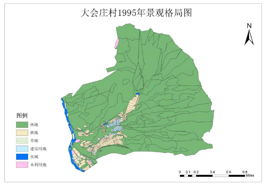
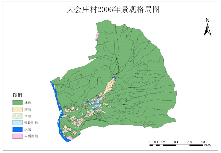
| 类型 | 1995年 | 2006年 | 2016年 | |||||
|---|---|---|---|---|---|---|---|---|
| 面积/hm2 | 占比/% | 面积/hm2 | 占比/% | 面积/hm2 | 占比/% | |||
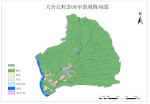
| 林地 | 400.19 | 90.56 | 407.02 | 92.11 | 408.19 | 92.37 | ||
| 耕地 | 25.40 | 5.75 | 17.88 | 4.05 | 15.59 | 3.53 | ||
| 草地 | 1.94 | 0.44 | 1.06 | 0.24 | 1.57 | 0.36 | ||
| 建筑用地 | 6.02 | 1.36 | 6.48 | 1.46 | 7.81 | 1.77 | ||
| 水域 | 5.60 | 1.27 | 7.38 | 1.67 | 7.55 | 1.71 | ||
| 未利用地 | 2.73 | 0.62 | 2.06 | 0.47 | 1.17 | 0.26 | ||
| 类型 | 1995年 | 2006年 | 2016年 | |||||
|---|---|---|---|---|---|---|---|---|
| 面积/hm2 | 占比/% | 面积/hm2 | 占比/% | 面积/hm2 | 占比/% | |||
| 林地 | 400.19 | 90.56 | 407.02 | 92.11 | 408.19 | 92.37 | ||
| 耕地 | 25.40 | 5.75 | 17.88 | 4.05 | 15.59 | 3.53 | ||
| 草地 | 1.94 | 0.44 | 1.06 | 0.24 | 1.57 | 0.36 | ||
| 建筑用地 | 6.02 | 1.36 | 6.48 | 1.46 | 7.81 | 1.77 | ||
| 水域 | 5.60 | 1.27 | 7.38 | 1.67 | 7.55 | 1.71 | ||
| 未利用地 | 2.73 | 0.62 | 2.06 | 0.47 | 1.17 | 0.26 | ||


| 景观指数 | 年份 | ||
|---|---|---|---|
| 1995 | 2006 | 2016 | |
| 周长面积比(PRAR) | 0.9216 | 0.9224 | 0.9081 |
| 斑块密度(PD) | 1.3782 | 1.3601 | 1.3488 |
| 连接度(CONNECT) | 6.4913 | 6.4038 | 6.3225 |
| 香农多样性指数(SHDI) | 0.5901 | 0.5815 | 0.5862 |
| 景观指数 | 年份 | ||
|---|---|---|---|
| 1995 | 2006 | 2016 | |
| 周长面积比(PRAR) | 0.9216 | 0.9224 | 0.9081 |
| 斑块密度(PD) | 1.3782 | 1.3601 | 1.3488 |
| 连接度(CONNECT) | 6.4913 | 6.4038 | 6.3225 |
| 香农多样性指数(SHDI) | 0.5901 | 0.5815 | 0.5862 |
| 林地 | 耕地 | 草地 | 建筑用地 | 水域 | 未利用地 | 1995年面积/hm2 | |
|---|---|---|---|---|---|---|---|
| 林地 | 398.70 | 0.54 | 0 | 0.32 | 0.12 | 0.50 | 400.19 |
| 耕地 | 7.90 | 16.97 | 0 | 0.11 | 0.07 | 0.36 | 25.40 |
| 草地 | 0 | 0 | 0.59 | 0 | 1.35 | 0 | 1.94 |
| 建筑用地 | 0.07 | 0 | 0 | 5.95 | 0 | 0 | 6.02 |
| 水域 | 0.04 | 0 | 0.47 | 0 | 5.10 | 0 | 5.60 |
| 未利用地 | 0.31 | 0.37 | 0 | 0.10 | 0.76 | 1.20 | 2.73 |
| 2006年面积/hm2 | 407.02 | 17.88 | 1.06 | 6.48 | 7.39 | 2.06 | 441.88 |
| 林地 | 耕地 | 草地 | 建筑用地 | 水域 | 未利用地 | 2006年面积/hm2 | |
|---|---|---|---|---|---|---|---|
| 林地 | 403.43 | 2.30 | 0 | 1.16 | 0.13 | 0 | 407.02 |
| 耕地 | 3.93 | 13.19 | 0.53 | 0.22 | 0 | 0 | 17.88 |
| 草地 | 0 | 0 | 0.89 | 0 | 0.18 | 0 | 1.07 |
| 建筑用地 | 0.07 | 0.10 | 0 | 6.30 | 0 | 0 | 6.48 |
| 水域 | 0 | 0 | 0.15 | 0 | 7.24 | 0 | 7.38 |
| 未利用地 | 0.76 | 0 | 0 | 0.13 | 0 | 1.17 | 2.06 |
| 2016年面积/hm2 | 408.19 | 15.59 | 1.57 | 7.81 | 7.55 | 1.17 | 441.88 |
| [1] | 卢爱刚, 王圣杰. 中国自然保护区发展状况分析[J]. 干旱区资源与环境, 2010, 24(11):7-11. |
| [2] | 董培升, 张国君. 青崖寨省级自然保护区[J]. 中国绿色画报, 2008(12):26-29. |
| [3] |
Huang Y, Fu J, Wang W, et al. Development of China’s nature reserves over the past 60 years: An overview[J]. Land Use Policy, 2019, 80:224-232.
doi: 10.1016/j.landusepol.2018.10.020 URL |
| [4] | 姚兴柱, 白根川, 管清琛. 成都平原边缘洪雅县农村居民点时空演变与景观格局[J]. 中国农学通报, 2017, 33(18):65-70. |
| [5] | 党国锋, 秦雯. 陇南山区乡村聚落空间格局研究[J]. 中国农学通报, 2018, 34(04):154-164. |
| [6] | 苏珊, 姚爱静, 赵庆磊, 等. 国家公园自然资源保护分区研究——以北京长城国家公园体制试点区为例[J]. 生态学报, 2019, 39(22):8319-8326. |
| [7] | 王晓军. 参与式地理信息系统研究综述[J]. 中国生态农业学报, 2010, 18(05):1138-1144. |
| [8] |
Wang X, Yu Z, Cinderby S, et al. Enhancing participation: Experiences of participatory geographic information systems in Shanxi province, China[J]. Applied Geography, 2008, 28(2):96-109.
doi: 10.1016/j.apgeog.2007.07.007 URL |
| [9] | Lovett A, Warren K. Using 3D visualization methods in landscape planning: An evaluation of options and practical issues[J]. Landscape & Urban Planning, 2015. |
| [10] | Appleton K, Lovett A. GIS-based visualisation of development proposals: reactions from planning and related professionals[J]. Computers Environment & Urban Systems, 2005, 29(3):321-339. |
| [11] | 张晓彤, 宇林军, 鲁永飞, 等. 基于三维电子沙盘的聚落开放空间可视性研究——以浙江省宁波市大堰镇为例[J]. 现代城市研究, 2019(03):56-61. |
| [12] | 张晓彤, 段进明, 宇林军, 等. 基于三维电子沙盘的参与式乡村历史景观评估:以贵州省对门山村为例[J]. 中国生态农业学报, 2017, 25(10):1403-1412. |
| [13] | Jebur A, Abed F, Mohammed M. Assessing the performance of commercial Agisoft PhotoScan software to deliver reliable data for accurate3D modelling[J]. MATEC Web of Conferences, 2018, 162. |
| [14] | 李秀全, 陈竹安, 张立亭. 非量测相机影像三维模型构建及精度检验[J]. 测绘科学, 2016, 41(06):144-147. |
| [15] | Lladó A P, Pineda-Herrero P, Pasamontes E G, et al. Participatory evaluation methodology for community plans and action. Three experiences of participatory evaluation in Catalunya[J]. Pedagogía Social: Revista Interuniversitaria, 2014,(24). |
| [16] |
Xiao D R, Tian B, Tian K, et al. Landscape patterns and their changes in Sichuan Ruoergai wetland national nature reserve[J]. Acta Ecologica Sinica, 2010, 30(1):27-32.
doi: 10.1016/j.chnaes.2009.12.005 URL |
| [17] | Christensen A A, Brandt J, Svenningsen S R. Landscape ecology[J]. International Encyclopedia of Geography: People,the Earth,Environment and Technology[J]. People,the Earth,Environment and Technology, 2016:1-10. |
| [18] | 方创琳, 周尚意, 柴彦威, 等. 中国人文地理学研究进展与展望[J]. 地理科学进展, 2011, 30(12):1470-1478. |
| [19] | 杨存建, 李何超, 李晓, 等. 基于多旋翼大疆无人机的土地利用正射遥感影像的快速获取方法研究[J]. 安徽农业科学, 2017, 45(33):60-62,64. |
| [20] | Li X Q, Chen Z A, Zhang L T, et al. Construction and Accuracy Test of a 3D Model of Non-Metric Camera Images Using Agisoft PhotoScan[J]. Procedia Environmental Sciences, 2016, 36. |
| [21] | 谢建春, 孙丙玉, 李文清, 等. 一种低空无人机航摄系统关键技术的试验研究[J]. 测绘通报, 2015(10):85-87,125. |
| [22] | 张志, 朱清科, 朱金兆, 等. 参与式农村评估(PRA)在流域景观格局研究中的应用——以晋西黄土区吉县蔡家川为例[J]. 中国水土保持科学, 2005,(01):25-31. |
| [23] | 王晓军, 田晋嘉, 张晓彤, 等. 基于村民记忆的乡村农耕景观变迁研究[J]. 生态与农村环境学报, 2019, 35(01):115-120. |
| [24] | 刘吉平, 赵丹丹, 田学智, 等. 1954—2010年三江平原土地利用景观格局动态变化及驱动力[J]. 生态学报, 2014, 34(12):3234-3244. |
| [25] | 李伟峰, 欧阳志云, 肖燚. 景观生态学原理在城市土地利用分类中的应用[J]. 生态学报, 2011, 31(03):593-601. |
| [26] | 石诗源, 鲍志良, 张小林. 村域农村居民点景观格局及其影响因素分析——以宜兴市8个村为例[J]. 中国农学通报, 2010, 26(08):290-293. |
| [27] | 郭少壮, 白红英, 孟清, 等. 秦岭地区林地与草地景观格局变化及其驱动因素[J]. 生态学报, 2020, 40(01):130-140. |
| [28] | 李子君, 刘金玉, 鲁成秀, 等. 基于土地利用变化的沂河流域景观格局与径流关系的分析[J]. 中国农业大学学报, 2020, 25(10):11-19. |
| [1] | MA Su, CUI Guoyi, ZHAO Yu, ZHAO Ying, LIU Xuezhen, ZHANG Chengdong. Spatial-temporal Variation Characteristics of NPP and the Driving Factors: A Case Study of Yan’an [J]. Chinese Agricultural Science Bulletin, 2022, 38(19): 93-98. |
| [2] | WANG Jing, FANG Feng, WANG Ying. Temporal Characteristics and Driving Factors of Sown Area Variation for Main Economic Crops in Southern China [J]. Chinese Agricultural Science Bulletin, 2022, 38(1): 114-124. |
| [3] | Wang Xie, Yang Qiao, Zeng Qiguo, Zhang Jianhua, Li Jingrui, Li Yiran, Zhu Yuhong. Spatial-temporal Pattern Evolution of Cultivated Land in Sichuan Province from 1999 to 2018 [J]. Chinese Agricultural Science Bulletin, 2021, 37(26): 110-116. |
| [4] | Sun Lina, Dong Aijing, Gong Yue. Research on Spatial Distribution Optimization of Rural Land Use in Heilongjiang Based on Sansheng Space——Taking Yongxing Town of Mingshui County as an example [J]. Chinese Agricultural Science Bulletin, 2020, 36(35): 156-164. |
| [5] | Chen Shanshan, Zang Shuying, Sun Li. Effects of Land Use Change on Habitat Quality Based on InVEST Model: A Case of the Songnen Plain [J]. Chinese Agricultural Science Bulletin, 2020, 36(3): 74-80. |
| [6] | 王晓娜,牟惟勇 and . Landscape Pattern Change of Land Use in Huangshi City [J]. Chinese Agricultural Science Bulletin, 2019, 35(9): 81-85. |
| [7] | Zhao Dandan and Hu Yecui. Spatial-temporal Characteristics of Intensive Land Use in the Yangtze River Delta Region [J]. Chinese Agricultural Science Bulletin, 2016, 32(20): 77-84. |
| [8] | . Analysis on Vegetation Landscape Pattern of Fujian Wuyishan Nature Reserve [J]. Chinese Agricultural Science Bulletin, 2015, 31(22): 206-212. |
| [9] | . Research on Landscape Pattern Change of Cultivated Land in Country on Medium Time Scale——A Case of Longhai City (County) Fujian Province [J]. Chinese Agricultural Science Bulletin, 2015, 31(17): 121-126. |
| [10] | . Analysis of Temporal and Spatial Variation & Driving Factors of Grain Production in Shanxi Province [J]. Chinese Agricultural Science Bulletin, 2014, 30(8): 82-88. |
| [11] |
Zhuang Lijuan, Qin Anchen, Zhao Zhijiang, Gao Guojing, Zhu Yufei, Jia Zhe.
Further Planning and Evaluating the Landscape of Wang Jiazhai Folk Custom Village of Hebei Province [J]. Chinese Agricultural Science Bulletin, 2009, 25(8): 205-209. |
| [12] |
Wu Wanrong, Tan Genjia, Qin Li, Jiang Hao, Wu Yan, Wu Congde, Bu Xunli.
Breeding New Early-mid Ripe Tomato Cultivar “Huangshan 1” and Their Resistant Identification to Tomato Bacterial Wilt [J]. Chinese Agricultural Science Bulletin, 2009, 25(8): 238-240. |
| [13] | Cao Ning,, Zhangyubin, Chen Xinping. SPATIAL-TEMPORAL CHANGE OF PHOSPHORUS BALANCE AND THE DRIVING FACTORS FOR AGROECOSYSTEMS IN CHINA [J]. Chinese Agricultural Science Bulletin, 2009, 25(13): 220-225. |
| [14] | Wang Junling, Wu Kening, Lv Qiaoling, Zhang Lei, Zhao Yuling. Study on the Cultivated Land Spatio-temporal Change and Driving Factors in Yanshi City [J]. Chinese Agricultural Science Bulletin, 2007, 23(7): 533-533. |
| [15] | Dong Tingting, Wang Qiubing. Landscape Pattern Changes of Wetlands in Donggang City and its Driving Force [J]. Chinese Agricultural Science Bulletin, 2006, 22(2): 257-257. |
| Viewed | ||||||
|
Full text |
|
|||||
|
Abstract |
|
|||||