Welcome to Chinese Agricultural Science Bulletin,
Chinese Agricultural Science Bulletin ›› 2023, Vol. 39 ›› Issue (23): 30-38.doi: 10.11924/j.issn.1000-6850.casb2022-0873
Special Issue: 资源与环境; 农业生态; 耕地保护
Previous Articles Next Articles
LI Xiaoqing1( ), WU Lin1(), HE Changyuan2
Received:2022-10-13
Revised:2022-12-25
Online:2023-08-15
Published:2023-08-10
LI Xiaoqing, WU Lin, HE Changyuan. Study on Cultivated Land Quality Level in the Upper Reaches of Xiangjiang River Hilly Region based on AHP and GIS: Take Dong’an County as an Example[J]. Chinese Agricultural Science Bulletin, 2023, 39(23): 30-38.
Add to citation manager EndNote|Ris|BibTeX
URL: https://www.casb.org.cn/EN/10.11924/j.issn.1000-6850.casb2022-0873


| 标度 | 含义 |
|---|---|
| 1 | 两个因素相比重要性相当 |
| 3 | 因素Ym与Yn相比,其中一个略显重要 |
| 5 | 因素Ym与Yn相比,其中一个明显重要 |
| 7 | 因素Ym与Yn相比,其中一个强烈重要 |
| 9 | 因素Ym与Yn相比,其中一个绝对重要 |
| 1~9 | 取该数值相邻判断中间的某一值 |
| 倒数 | 若因素Ym与Yn的重要性之比为Ymn, 则因素Yn与Ym的关系是Ymn=1/Ynm |
| 标度 | 含义 |
|---|---|
| 1 | 两个因素相比重要性相当 |
| 3 | 因素Ym与Yn相比,其中一个略显重要 |
| 5 | 因素Ym与Yn相比,其中一个明显重要 |
| 7 | 因素Ym与Yn相比,其中一个强烈重要 |
| 9 | 因素Ym与Yn相比,其中一个绝对重要 |
| 1~9 | 取该数值相邻判断中间的某一值 |
| 倒数 | 若因素Ym与Yn的重要性之比为Ymn, 则因素Yn与Ym的关系是Ymn=1/Ynm |
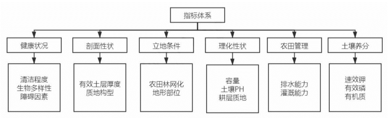
| 指标 | 健康状况A | 剖面性状B | 立地条件C | 理化性状D | 农田管理E | 土壤养分F | 组合权重(相乘) |
|---|---|---|---|---|---|---|---|
| 0.0686 | 0.149 | 0.1728 | 0.1851 | 0.2022 | 0.2223 | ||
| 清洁程度A1 | 0.4065 | 0.14034 | |||||
| 生物多样性A2 | 0.5935 | 0.13766 | |||||
| 障碍因素A3 | 0.2874 | 0.10795 | |||||
| 有效土层厚度B1 | 0.3509 | 0.07557 | |||||
| 质地构型B2 | 0.3617 | 0.06603 | |||||
| 农田林网化C1 | 0.1876 | 0.06477 | |||||
| 地形部位C2 | 0.8124 | 0.05725 | |||||
| 容重D1 | 0.2359 | 0.05676 | |||||
| 耕层质地D2 | 0.3568 | 0.05393 | |||||
| 土壤pH D3 | 0.4074 | 0.05229 | |||||
| 排水能力E1 | 0.3195 | 0.04379 | |||||
| 灌溉能力E2 | 0.6805 | 0.04273 | |||||
| 速效钾F1 | 0.2557 | 0.04072 | |||||
| 有效磷F2 | 0.2578 | 0.03239 | |||||
| 有机质F3 | 0.4865 | 0.02783 |
| 评价指标 | 函数类型 | 公式 | a1 | ui1 | ui2 | ci |
|---|---|---|---|---|---|---|
| 有效土层厚度 | 戒上型 | Y=1/[1+a1(ui-ci)2] | 0.000205 | 10 | 无 | 99.092342 |
| 有机质 | 戒上型 | Y=1/[1+a1(ui-ci)2] | 0.001842 | 0 | 无 | 33.656446 |
| 有效磷 | 戒上型 | Y=1/[1+a1(ui-ci)2] | 0.002025 | 0 | 无 | 33.346824 |
| 速效钾 | 戒上型 | Y=1/[1+a1(ui-ci)2] | 0.000081 | 5 | 无 | 181.62535 |
| pH | 峰型 | Y=1/[1+a1(ui-ci)2] | 0.221129 | 3 | 10 | 6.811204 |
| 容重 | 峰型 | Y=1/[1+a1(ui-ci)2] | 2.236726 | 0.5 | 3.21 | 1.211674 |
| 评价指标 | 函数类型 | 条件 | 隶属度Wi |
|---|---|---|---|
| 地形部位 | 概念型 | 平原低阶 | 1 |
| 款谷盆地 | 0.95 | ||
| 平原中阶 | 0.95 | ||
| 平原高阶 | 0.9 | ||
| 山间盆地 | 0.8 | ||
| 丘陵下部 | 0.8 | ||
| 丘陵中部 | 0.7 | ||
| 山地坡下 | 0.68 | ||
| 丘陵上部 | 0.6 | ||
| 山地坡中 | 0.45 | ||
| 山地坡上 | 0.3 | ||
| 土壤质地 | 概念型 | 中壤 | 1 |
| 重壤 | 0.95 | ||
| 轻壤 | 0.9 | ||
| 砂壤 | 0.85 | ||
| 黏土 | 0.7 | ||
| 砂土 | 0.6 | ||
| 排水能力 | 概念型 | 充分满足 | 1 |
| 满足 | 0.8 | ||
| 基本满足 | 0.6 | ||
| 不满足 | 0.3 | ||
| 清洁程度 | 概念型 | 清洁 | 1 |
| 尚清洁 | 0.8 | ||
| 质地构型 | 概念型 | 上松下紧型 | 1 |
| 海绵型 | 0.95 | ||
| 夹层型 | 0.85 | ||
| 紧实型 | 0.75 | ||
| 薄层型 | 0.55 | ||
| 下紧上松型 | 0.4 | ||
| 松散型 | 0.3 | ||
| 障碍因素 | 概念型 | 无 | 1 |
| 酸化 | 0.7 | ||
| 瘠薄 | 0.65 | ||
| 障碍层次 | 0.6 | ||
| 渍潜 | 0.55 | ||
| 盐碱 | 0.5 |
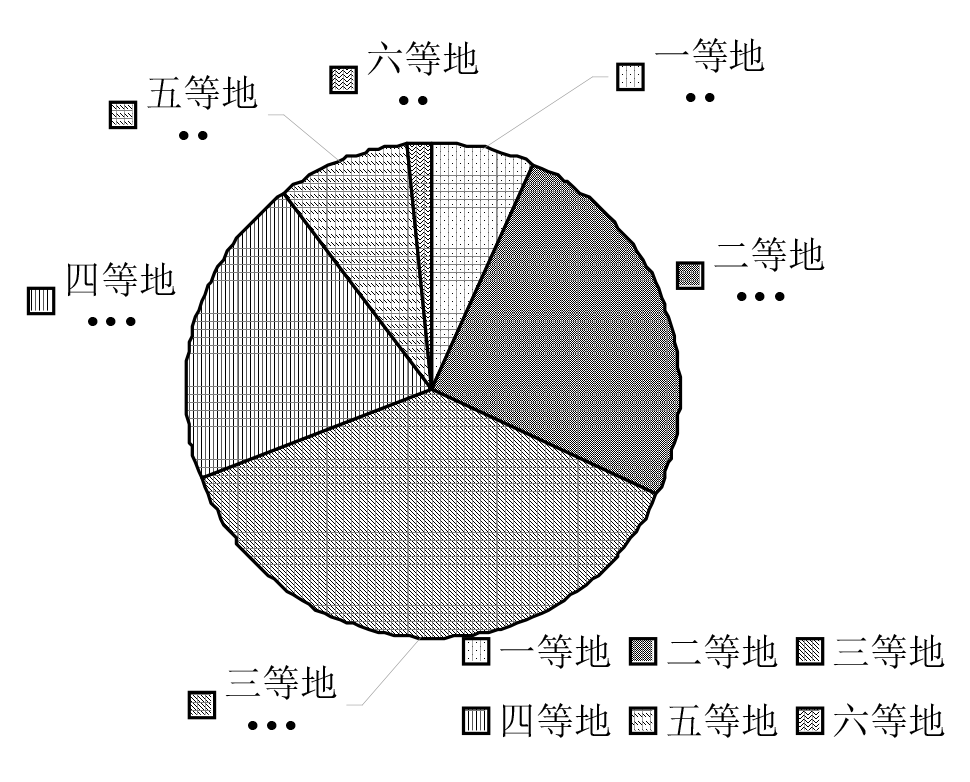
| 耕地等级 | 耕地地力指数Q |
|---|---|
| 一等地 | Q≥0.9170 |
| 二等地 | 0.8924≤Q<0.9170 |
| 三等地 | 0.8678≤Q<0.8924 |
| 四等地 | 0.8431≤Q<0.8678 |
| 五等地 | 0.8185≤Q<0.8431 |
| 六等地 | 0.7939≤Q<0.8185 |
| 七等地 | 0.7693≤Q<0.7939 |
| 八等地 | 0.7466≤Q<0.7693 |
| 九等地 | 0.7200≤Q<0.7466 |
| 十等地 | Q≤0.7200 |
| 耕地等级 | 耕地地力指数Q |
|---|---|
| 一等地 | Q≥0.9170 |
| 二等地 | 0.8924≤Q<0.9170 |
| 三等地 | 0.8678≤Q<0.8924 |
| 四等地 | 0.8431≤Q<0.8678 |
| 五等地 | 0.8185≤Q<0.8431 |
| 六等地 | 0.7939≤Q<0.8185 |
| 七等地 | 0.7693≤Q<0.7939 |
| 八等地 | 0.7466≤Q<0.7693 |
| 九等地 | 0.7200≤Q<0.7466 |
| 十等地 | Q≤0.7200 |


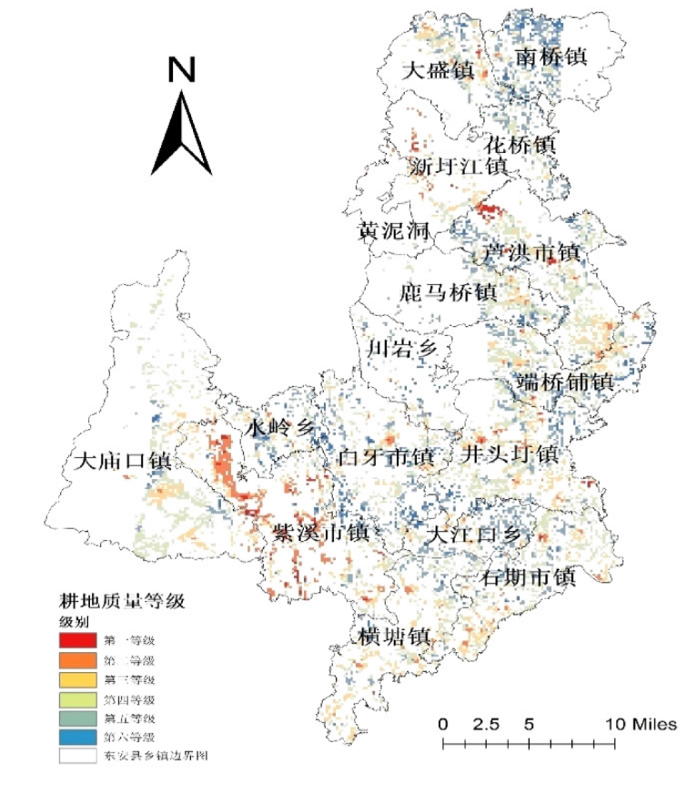
| 镇名 | 单位 | 一等地 | 二等地 | 三等地 | 四等地 | 五等地 | 六等地 | 合计 | |||||||||||
|---|---|---|---|---|---|---|---|---|---|---|---|---|---|---|---|---|---|---|---|
| 黄泥洞 | 面积/hm2 | 0.00 | 14.85 | 22.27 | 25.98 | 22.27 | 0.00 | 85.36 | |||||||||||
| 比例/% | 0 | 17 | 26 | 30 | 26 | 0 | 100 | ||||||||||||
| 白牙市镇 | 面积/hm2 | 415.67 | 890.72 | 994.64 | 475.05 | 100.21 | 7.42 | 2883.71 | |||||||||||
| 比例/% | 14 | 31 | 34 | 16 | 3 | 0 | 100 | ||||||||||||
| 井头圩镇 | 面积/hm2 | 181.86 | 827.63 | 1529.07 | 827.63 | 185.57 | 37.11 | 3588.87 | |||||||||||
| 比例/% | 5 | 23 | 43 | 23 | 5 | 1 | 100 | ||||||||||||
| 川言乡 | 面积/hm2 | 133.61 | 226.39 | 204.12 | 51.96 | 29.69 | 0.00 | 645.77 | |||||||||||
| 比例/% | 21 | 35 | 32 | 8 | 5 | 0 | 100 | ||||||||||||
| 芦洪市镇 | 面积/hm2 | 170.72 | 805.36 | 1547.63 | 749.69 | 155.88 | 152.16 | 3581.44 | |||||||||||
| 比例/% | 5 | 22 | 43 | 21 | 4 | 4 | 100 | ||||||||||||
| 大江口乡 | 面积/hm2 | 148.45 | 701.44 | 274.64 | 155.88 | 22.27 | 0.00 | 1302.68 | |||||||||||
| 比例/% | 11 | 54 | 21 | 12 | 2 | 0 | 100 | ||||||||||||
| 鹿马桥镇 | 面积/hm2 | 74.23 | 430.52 | 823.92 | 178.14 | 44.54 | 3.71 | 1555.05 | |||||||||||
| 比例/% | 5 | 28 | 53 | 11 | 3 | 0 | 100 | ||||||||||||
| 大庙口 | 面积/hm2 | 63.09 | 270.93 | 1859.38 | 753.40 | 148.45 | 11.13 | 3106.39 | |||||||||||
| 比例/% | 2 | 9 | 60 | 24 | 5 | 0 | 100 | ||||||||||||
| 南桥镇 | 面积/hm2 | 341.44 | 1091.13 | 367.42 | 81.65 | 18.56 | 0.00 | 1900.21 | |||||||||||
| 比例/% | 18 | 57 | 19 | 4 | 1 | 0 | 100 | ||||||||||||
| 大盛镇 | 面积/hm2 | 66.80 | 504.74 | 638.35 | 341.44 | 89.07 | 14.85 | 1655.26 | |||||||||||
| 比例/% | 4 | 30 | 39 | 21 | 5 | 1 | 100 | ||||||||||||
| 石期镇 | 面积/hm2 | 74.23 | 463.92 | 1217.32 | 734.85 | 167.01 | 14.85 | 2672.16 | |||||||||||
| 比例/% | 3 | 17 | 46 | 28 | 6 | 1 | 100 | ||||||||||||
| 水岭乡 | 面积/hm2 | 152.16 | 449.07 | 289.48 | 170.72 | 51.96 | 0.00 | 1113.40 | |||||||||||
| 比例/% | 14% | 40% | 26% | 15% | 5% | 0% | 100% | ||||||||||||
| 端桥铺 | 面积/hm2 | 218.97 | 745.98 | 1131.96 | 504.74 | 89.07 | 11.13 | 2701.86 | |||||||||||
| 比例/% | 8% | 28% | 42% | 19% | 3% | 0% | 100% | ||||||||||||
| 花桥镇 | 面积/hm2 | 37.11 | 463.92 | 326.60 | 74.23 | 7.42 | 0.00 | 909.28 | |||||||||||
| 比例/% | 4% | 51% | 36% | 8% | 1% | 0% | 100% | ||||||||||||
| 横塘镇 | 面积/hm2 | 40.82 | 430.52 | 835.05 | 835.05 | 115.05 | 3.71 | 2260.21 | |||||||||||
| 比例/% | 2% | 19% | 37% | 37% | 5% | 0% | 100% | ||||||||||||
| 新圩江 | 面积/hm2 | 3.71 | 55.67 | 163.30 | 267.22 | 163.30 | 40.82 | 694.02 | |||||||||||
| 比例/% | 1% | 8% | 24% | 39% | 24% | 6% | 100% | ||||||||||||
| 紫溪市 | 面积/hm2 | 122.47 | 274.64 | 567.84 | 757.11 | 1562.47 | 259.79 | 3544.33 | |||||||||||
| 比例/% | 3% | 8% | 16% | 21% | 44% | 7% | 100% | ||||||||||||


| [1] |
李萍, 王军. 中国耕地质量保护与提升:一个历史演进的视角——纪念改革开放40周年暨新中国成立70周年[C]. 全国高校社会主义经济理论与实践研讨会领导小组.社会主义经济理论研究集萃(2018):高质量发展的中国经济. 全国高校社会主义经济理论与实践研讨会领导小组: 中国人民大学中国经济改革与发展研究院, 2018:250-265.
|
| [2] |
董利民, 万磊, 王雅鹏. 试论我国农地资源的稀缺性与土地整理的必要性[C]. 2006年和谐社会与新农村发展国际学术研讨会, 2006:64-71.
|
| [3] |
张敏. 耕地质量评价方法研究概述[J]. 农村经济与科技, 2020, 31(21):10-12.
|
| [4] |
朱瑕, 张立亭, 靳焕焕. 基于因素法和SVM模型的耕地质量评价方法研究[J]. 土壤通报, 2020, 51(3):561-567.
|
| [5] |
唐宗, 周悟, 杨颢, 等. 基于交互效应Logistic回归模型的耕地质量评价方法研究[J]. 生态环境学报, 2020, 29(12):2394-2403.
doi: 10.16258/j.cnki.1674-5906.2020.012.010 |
| [6] |
何新莹, 聂艳, 王朴, 等. 基于改进灰靶模型的耕地质量评价方法与实证[J]. 土壤学报:1-11.
|
| [7] |
杨君, 邵劲松, 周鹏全, 等. 基于地块尺度的耕地质量级别变化及农业空间保护——以岳阳市岳阳楼区为例[J]. 经济地理, 2021, 41(11):185-192.
|
| [8] |
王丽, 周勇, 李晴, 等. 基于随机森林的耕地质量评价智能模型及其应用研究[J]. 土壤学报, 2022, 59(5):1279-1292.
|
| [9] |
张新乐, 钱蕾, 鲍依临, 等. 黑土区田块尺度耕地质量遥感监测与评价[J]. 土壤通报, 2020, 51(6):1303-1312.
|
| [10] |
陈文广, 孔祥斌, 廖宇波, 等. 黄土高原区耕地质量评价——以陕西省延川县为例[J]. 水土保持研究, 2021, 28(2):375-381.
|
| [11] |
徐雪生, 骆检兰, 黄逢秋, 等. 富硒耕地质量评价体系构建及其在湖南省新田县新圩镇的应用[J]. 中国地质, 2022, 49(3):789-801.
|
| [12] |
于美荣. 2019年天津市耕地质量监测评价结果分析[J]. 天津农林科技, 2021(4):37-39.
|
| [13] |
龙晓辉. 基于3S技术的东安县耕地土壤肥力特征及其分级评价[D]. 长沙: 湖南农业大学, 2010.
|
| [14] |
赵赛男. 长沙市耕地质量评价[D]. 长沙: 湖南农业大学, 2019.
|
| [15] |
中华人民共和国农业农村部. GB/T 33469—2016,《耕地质量等级》[S]. 中国国家标准化管理委员会, 2016.
|
| [16] |
胡建军. 东安县粮食高产创建技术的推广[J]. 作物研究, 2015, 29(1):67-68,76.
|
| [17] |
赵建军, 张洪岩, 王野乔, 等. 基于AHP和GIS的省级耕地质量评价研究——以吉林省为例[J]. 土壤通报, 2012, 43(1):70-75.
|
| [18] |
方琳娜, 宋金平. 基于SPOT多光谱影像的耕地质量评价——以山东省即墨市为例[J]. 地理科学进展, 2008(5):71-78.
doi: 10.11820/dlkxjz.2008.05.010 |
| [19] |
曹胜, 周卫军, 王凡荣, 等. 东安县水稻测土配方施肥专家信息系统研制与推广示范[J]. 农业网络信息, 2015(9):66-71.
|
| [20] |
刘鹏. 孙吴县耕地质量评价[D]. 哈尔滨: 东北农业大学, 2020.
|
| [21] |
张苹. 富锦市耕地质量评价[D]. 哈尔滨: 东北农业大学, 2018.
|
| [22] |
孙晓兵, 孔祥斌, 温良友. 基于耕地要素的耕地质量评价指标体系研究及其发展趋势[J]. 土壤通报, 2019, 50(3):739-747.
|
| [23] |
曹新竹. 下辽河平原区耕地质量等别评价及提升潜力研究[D]. 沈阳: 沈阳农业大学, 2019.
|
| [24] |
范佳旭, 汤江龙. 耕地质量相关研究综述[J]. 住宅与房地产, 2019(18):248-250.
|
| [25] |
许树柏. 实用决策方法:层次分析法原理[M]. 天津: 天津大学出版社, 1988.
|
| [26] |
程晋南, 赵庚星, 张子雪, 等. 基于GIS的小尺度耕地质量综合评价研究——以山东省丁庄镇为例[J]. 自然资源学报, 2009, 24(3):536-544.
doi: 10.11849/zrzyxb.2009.03.019 |
| [1] | LI Feiran, WANG Yongqi. Comprehensive Evaluation Methods of Nutritive Value of Forage Wild Plant Leaves in Distribution Areas of Forest Musk Deer [J]. Chinese Agricultural Science Bulletin, 2023, 39(8): 119-126. |
| [2] | ZHANG Qiulu. A Comprehensive Evaluation of the Colored-leaf Tree Species Introduced to the Huai’an Section of Beijing-Hangzhou Grand Canal Based on Analytic Hierarchy Process [J]. Chinese Agricultural Science Bulletin, 2023, 39(8): 15-20. |
| [3] | LIAO Heting, ZHENG Yao, WANG Ning, AN Shuwei, Gu Lingling, CHEN Jiazhang. Analysis of Plankton Community Structure Characteristics of Lotus Root-Crayfish Culture Model in Different Areas of Northern Jiangsu [J]. Chinese Agricultural Science Bulletin, 2023, 39(8): 156-164. |
| [4] | ZHAO Shouping, XIAO Wendan, CHEN De, YE Xuezhu, ZHANG Qi, WU Shaofu, HU Jing, GAO Na, HUANG Miaojie. Evaluation of Heavy Metal Passivation in Contaminated Paddy Fields Based on Soil Quality and Rice Safety [J]. Chinese Agricultural Science Bulletin, 2023, 39(8): 51-62. |
| [5] | LIU Yuanyuan, TU Guoliang. Available Trace Elements in Cultivated Soil in Pingliang City: Abundance and Deficiency Evaluation and Influencing Factors [J]. Chinese Agricultural Science Bulletin, 2023, 39(4): 83-92. |
| [6] | GUAN Tikun, LIU Zilu, LI Xiaoyu, WANG Jianli, HOU Shuangying, LIU Xushan, XU Shiyi, CHEN Qingjun, ZHANG Guoqing. Biochar from Spent Mushroom Substrate of Industrial Pleurotus eryngii: Preparation Process and Quality Evaluation [J]. Chinese Agricultural Science Bulletin, 2023, 39(3): 71-79. |
| [7] | YE Pei, LIU Zhixiong, LIU Kaiwen, LIU Kequn. Technology and Application of Climate Quality Evaluation for Crayfish [J]. Chinese Agricultural Science Bulletin, 2023, 39(24): 149-156. |
| [8] | LI Feiran, WANG Yongqi. Forage Plant Leaves of Captive Forest Musk Deer (Moschus berezovskii): Characteristics and Comprehensive Analysis of Main Mineral Elements [J]. Chinese Agricultural Science Bulletin, 2023, 39(24): 157-164. |
| [9] | CAI Xun, LIANG Junfen, FENG Shanshan, ZHOU Canfang. Evaluation and Countermeasures of Multifunctional Development of Urban Modern Agriculture in Foshan [J]. Chinese Agricultural Science Bulletin, 2023, 39(23): 145-152. |
| [10] | YUAN Wenbin, HUANG Hao, GUAN Luohao, LI Chao, WANG Wenhui, XIE Danfeng, YANG Tianxu, WANG Wei. Regional Classification of Flue-cured Tobacco Quality Characteristics in Huili Tobacco Area [J]. Chinese Agricultural Science Bulletin, 2023, 39(22): 96-103. |
| [11] | JIANG Bing, WANG Songtao, SUN Zengbing, ZHANG Hairui, WANG Jian, LIU Yang. Evaluation of Cultivated Land Soil Fertility Based on Membership Function and Principal Component Analysis [J]. Chinese Agricultural Science Bulletin, 2023, 39(2): 22-27. |
| [12] | LIANG Huan, AN Yue. The Quality Evaluation of Foeniculi fructus from Different Production Origins [J]. Chinese Agricultural Science Bulletin, 2023, 39(19): 148-152. |
| [13] | ZHANG Zhuanyong, SHEN Zhong, HUANG He, JI Zeshun, HU Jiatian, WANG Huayu, MA Wubiao, MA Xiang, WANG Luoping, YAN Hui, YU Fengtang. Adaptability of Flue-cured Tobacco Varieties to Different Meteorological Conditions in Zhaotong [J]. Chinese Agricultural Science Bulletin, 2023, 39(18): 94-100. |
| [14] | FU Ying, ZHANG Liankui, LI Wurijimusi, GUO Longyu, WANG Jingyu, GAO Xinmei, WANG Wei, XU Xingjian, WANG Ying, ZHANG Mingwei, WURILIGE, WANG Yingjie. 20 Sorghum Varieties Introduced in Hinggan League: The Evaluation by Membership Function Model [J]. Chinese Agricultural Science Bulletin, 2023, 39(18): 19-25. |
| [15] | SHI Jinrong, LIU Dian, WANG Yongming, HAN Yu, XIE Biwen. Nutrienal Composition Analysis and Evaluation of Sinibotia pulchra [J]. Chinese Agricultural Science Bulletin, 2023, 39(17): 124-130. |
| Viewed | ||||||
|
Full text |
|
|||||
|
Abstract |
|
|||||