欢迎访问《中国农学通报》,
中国农学通报 ›› 2021, Vol. 37 ›› Issue (14): 123-135.doi: 10.11924/j.issn.1000-6850.casb2020-0241
刘月阳1( ), 杜崇1, 龚文峰2(), 刘铁冬2, 聂堂哲1, 刘涛1, 曹凯华1, 徐铖龙1
收稿日期:2020-07-06
修回日期:2020-09-15
出版日期:2021-05-15
发布日期:2021-05-19
通讯作者:
龚文峰
作者简介:刘月阳,女,1994年出生,黑龙江大庆人,硕士研究生,研究方向为水土资源与环境。通信地址:150080 黑龙江省哈尔滨市南岗区学府路74号黑龙江大学,E-mail: 基金资助:
Liu Yueyang1(), Du Chong1, Gong Wenfeng2(), Liu Tiedong2, Nie Tangzhe1, Liu Tao1, Cao Kaihua1, Xu Chenglong1
Received:2020-07-06
Revised:2020-09-15
Online:2021-05-15
Published:2021-05-19
Contact:
Gong Wenfeng
摘要:
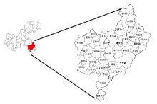
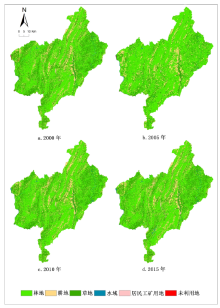
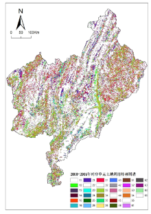
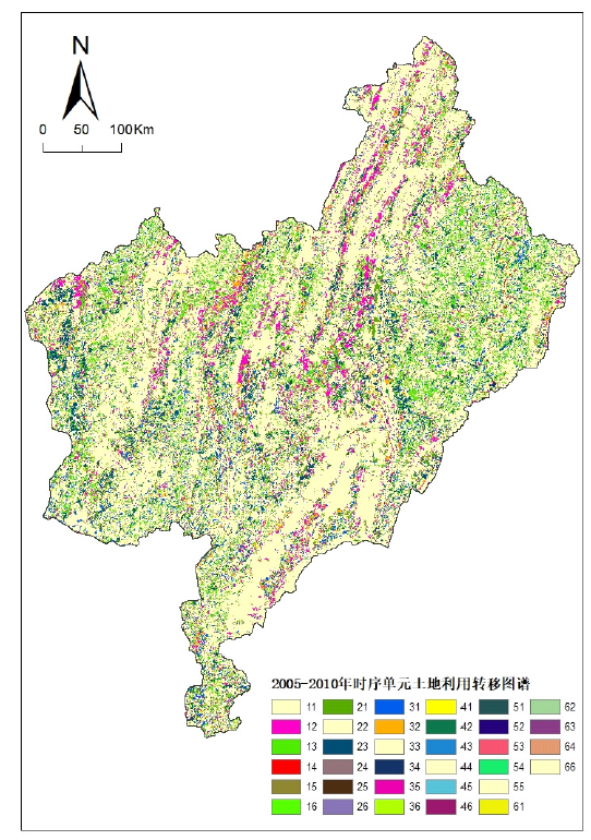
探究2000—2015年间酉阳县土地利用演变特征规律及地理生态过程,为实现区域土地资源可持续利用提供科学依据。本研究运用图谱理论信息学探究区域土地利用空间分布特征和时空演变规律。结果表明:15年间研究区不同地类呈现不同的发展趋势,土地利用结构主要以林地和草地为主,面积比例分别为86.79%、88.54%、86.13%和85.86%,林地占据一定优势地位。3个时序单元的主要图谱单元类型及面积存在一定的差异性;土地利用涨势和落势图谱中,林地涨势面积最大,占新增面积比例的38.67%,草地落势面积最大,占萎缩面积的比例为38.03%。该研究为今后酉阳县土地利用可持续发展和生态建设提供理论依据和科学支持。
中图分类号:
刘月阳, 杜崇, 龚文峰, 刘铁冬, 聂堂哲, 刘涛, 曹凯华, 徐铖龙. 基于地学图谱的县级尺度土地利用时空变化特征研究——以酉阳土家族苗族自治县为例[J]. 中国农学通报, 2021, 37(14): 123-135.
Liu Yueyang, Du Chong, Gong Wenfeng, Liu Tiedong, Nie Tangzhe, Liu Tao, Cao Kaihua, Xu Chenglong. The Characteristics of Temporal and Spatial Changes of Land Use at County Level Based on Geographical Atlas—Take Youyang Tujia and Miao Autonomous County as an Example[J]. Chinese Agricultural Science Bulletin, 2021, 37(14): 123-135.


| 土地利用类型 | 2000年 | 2005年 | 2010年 | 2015年 | ||||
|---|---|---|---|---|---|---|---|---|
| 面积/km2 | 比例/% | 面积/km2 | 比例/% | 面积/km2 | 比例/% | 面积/km2 | 比例/% | |
| 林地 | 2725.70 | 52.95 | 3430.59 | 66.64 | 2793.72 | 54.27 | 2789.64 | 54.19 |
| 草地 | 1742.22 | 33.84 | 1127.13 | 21.90 | 1640.07 | 31.86 | 1630.36 | 31.67 |
| 耕地 | 630.64 | 12.25 | 557.81 | 10.84 | 660.77 | 12.84 | 660.10 | 12.82 |
| 水域 | 24.22 | 0.47 | 22.87 | 0.44 | 30.81 | 0.60 | 35.40 | 0.69 |
| 居民工矿用地 | 19.71 | 0.38 | 7.29 | 0.14 | 21.94 | 0.43 | 31.83 | 0.62 |
| 未利用地 | 5.26 | 0.10 | 2.04 | 0.04 | 0.43 | 0.01 | 0.42 | 0.01 |
| 合计 | 5147.75 | 5147.75 | 5147.75 | 5147.75 | ||||
| 土地利用类型 | 2000—2005年 | 2005—2010年 | 2010—2015年 | 2000—2015年 |
|---|---|---|---|---|
| 林地 | 5.17 | -3.71 | -0.03 | 0.47 |
| 耕地 | -2.31 | 3.69 | -0.02 | 0.93 |
| 草地 | -7.06 | 9.10 | -0.12 | -1.28 |
| 水域 | -1.11 | 6.95 | 2.98 | 9.23 |
| 居民工矿用地 | -12.60 | 40.20 | 9.02 | 12.30 |
| 未利用地 | -12.23 | -15.81 | -0.38 | -18.40 |

| 编码 | 土地利用转移图谱单元 | 图谱单元数/个 | 面积/km2 | 土地利用变化比率/% |
|---|---|---|---|---|
| 31 | 草地→林地 | 772459 | 695.21 | 38.09 |
| 21 | 耕地→林地 | 381137 | 343.02 | 18.80 |
| 32 | 草地→耕地 | 310816 | 279.73 | 15.33 |
| 13 | 林地→草地 | 231436 | 208.29 | 11.41 |
| 23 | 耕地→草地 | 152506 | 137.26 | 7.52 |
| 12 | 林地→耕地 | 137679 | 123.91 | 6.79 |
| 53 | 居民工矿用地→草地 | 11820 | 10.64 | 0.58 |
| 41 | 水域→林地 | 7738 | 6.96 | 0.38 |
| 43 | 水域→草地 | 5397 | 4.86 | 0.27 |
| 51 | 居民工矿用地→林地 | 4249 | 3.82 | 0.21 |
| 14 | 林地→水域 | 4144 | 3.73 | 0.20 |
| 34 | 草地→水域 | 4107 | 3.70 | 0.20 |
| 63 | 未利用地→草地 | 2745 | 2.47 | 0.14 |
| 52 | 居民工矿用地→耕地 | 1558 | 1.40 | 0.08 |
| 2000年 | 2005年 | |||||
|---|---|---|---|---|---|---|
| 林地 | 耕地 | 草地 | 水域 | 居民工矿用地 | 未利用地 | |
| 林地 | 0.876523 | 0.045462 | 0.076420 | 0.001368 | 0.000223 | 0.000004 |
| 耕地 | 0.543937 | 0.238043 | 0.217648 | 0.000213 | 0.000156 | 0.000004 |
| 草地 | 0.399045 | 0.160565 | 0.437014 | 0.002122 | 0.001236 | 0.000018 |
| 水域 | 0.287519 | 0.026233 | 0.200535 | 0.458700 | 0.024189 | 0.002824 |
| 居民工矿用地 | 0.194018 | 0.071142 | 0.539726 | 0.006027 | 0.189087 | 0 |
| 未利用地 | 0.114917 | 0.008734 | 0.470115 | 0.042816 | 0 | 0.363418 |

| 编码 | 土地利用转移图谱单元 | 图谱单元数/个 | 面积/km2 | 土地利用变化比率/% |
|---|---|---|---|---|
| 13 | 林地→草地 | 731537 | 658.38 | 35.61 |
| 12 | 林地→耕地 | 393323 | 353.99 | 19.15 |
| 23 | 耕地→草地 | 297358 | 267.62 | 14.48 |
| 31 | 草地→林地 | 272955 | 245.66 | 13.29 |
| 32 | 草地→耕地 | 165903 | 149.31 | 8.08 |
| 21 | 耕地→林地 | 143095 | 128.79 | 6.97 |
| 35 | 草地→居民工矿用地 | 13704 | 12.33 | 0.67 |
| 14 | 林地→水域 | 8207 | 7.39 | 0.40 |
| 34 | 草地→水域 | 7816 | 7.03 | 0.38 |
| 15 | 林地→居民工矿用地 | 4415 | 3.97 | 0.21 |
| 41 | 水域→林地 | 4330 | 3.90 | 0.21 |
| 43 | 水域→草地 | 2760 | 2.48 | 0.13 |
| 64 | 未利用地→水域 | 1984 | 1.79 | 0.10 |
| 54 | 居民工矿用地→水域 | 1786 | 1.61 | 0.09 |
| 25 | 耕地→居民工矿用地 | 1686 | 1.52 | 0.08 |
| 53 | 居民工矿用地→草地 | 1183 | 1.06 | 0.06 |
| 24 | 耕地→水域 | 778 | 0.70 | 0.04 |
| 51 | 居民工矿用地→林地 | 467 | 0.42 | 0.02 |
| 2005年 | 2010年 | ||||||
|---|---|---|---|---|---|---|---|
| 林地 | 耕地 | 草地 | 水域 | 居民工矿用地 | 未利用地 | ||
| 林地 | 0.702259 | 0.102943 | 0.191463 | 0.002148 | 0.001156 | 0.000032 | |
| 耕地 | 0.231693 | 0.282840 | 0.481468 | 0.001260 | 0.002730 | 0.000010 | |
| 草地 | 0.218388 | 0.132737 | 0.631566 | 0.006253 | 0.010964 | 0.000091 | |
| 水域 | 0.204932 | 0.007147 | 0.130626 | 0.646694 | 0.007194 | 0.003408 | |
| 居民工矿用地 | 0.058602 | 0.013678 | 0.148450 | 0.224118 | 0.555151 | 0 | |
| 未利用地 | 0.011995 | 0.006219 | 0.028432 | 0.881386 | 0 | 0.071968 | |
| 编码 | 土地利用转移图谱单元 | 图谱单元数/个 | 面积/km2 | 土地利用变化比率/% |
|---|---|---|---|---|
| 35 | 草地→居民工矿用地 | 9054 | 8.15 | 54.58 |
| 14 | 林地→水域 | 2736 | 2.46 | 16.49 |
| 15 | 林地→居民工矿用地 | 1775 | 1.60 | 10.70 |
| 34 | 草地→水域 | 1705 | 1.53 | 10.28 |
| 25 | 耕地→居民工矿用地 | 443 | 0.40 | 2.67 |
| 54 | 居民工矿用地→水域 | 347 | 0.31 | 2.09 |
| 45 | 水域→居民工矿用地 | 59 | 0.05 | 0.36 |
| 12 | 林地→耕地 | 43 | 0.04 | 0.26 |
| 32 | 草地→耕地 | 24 | 0.02 | 0.14 |
| 31 | 草地→林地 | 15 | 0.01 | 0.09 |
| 65 | 未利用地→居民工矿用地 | 9 | 0.01 | 0.05 |

| 2010年 | 2015年 | |||||
|---|---|---|---|---|---|---|
| 林地 | 耕地 | 草地 | 水域 | 居民工矿用地 | 未利用地 | |
| 林地 | 0.998532 | 0.000014 | 0.000001 | 0.000881 | 0.000572 | 0 |
| 耕地 | 0.000004 | 0.998884 | 0.000001 | 0.000507 | 0.000603 | 0 |
| 草地 | 0.000008 | 0.000013 | 0.994075 | 0.000936 | 0.004968 | 0 |
| 水域 | 0.000029 | 0 | 0 | 0.998248 | 0.001723 | 0 |
| 居民工矿用地 | 0 | 0 | 0.000082 | 0.014232 | 0.985686 | 0 |
| 未利用地 | 0 | 0 | 0 | 0 | 0.018947 | 0.981053 |

| 时段/年 | 新增林地 | 新增耕地 | 新增草地 | 新增水域 | 新增居民工矿用地 | 新增未利用地 | 未变区域 |
|---|---|---|---|---|---|---|---|
| 2000—2005 | 1049.63 | 405.73 | 363.51 | 7.90 | 3.45 | 0.11 | 3317.30 |
| 2005—2010 | 378.79 | 503.55 | 929.61 | 18.51 | 17.96 | 0.28 | 3298.93 |
| 2010—2015 | 0.02 | 0.06 | 0.01 | 4.64 | 10.21 | 0.00 | 5132.82 |
| 合计 | 1428.43 | 909.34 | 1293.13 | 31.06 | 31.61 | 0.40 | 11749.04 |

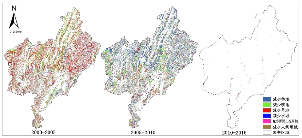
| 时段/年 | 减少林地 | 减少耕地 | 减少草地 | 减少水域 | 减少居民工矿用地 | 减少未利用地 | 不变区域 |
|---|---|---|---|---|---|---|---|
| 2000-2005 | 336.55 | 480.51 | 980.83 | 13.11 | 15.98 | 3.35 | 3317.30 |
| 2005-2010 | 1023.84 | 398.63 | 414.44 | 6.72 | 3.19 | 1.88 | 3298.93 |
| 2010-2015 | 4.10 | 0.74 | 9.72 | 0.05 | 0.31 | 0.01 | 5132.82 |
| 合计 | 1364.50 | 879.88 | 1404.99 | 19.88 | 19.49 | 5.23 | 11749.04 |
| [1] |
李秀彬. 全球环境变化研究的核心领域-土地利用/土地覆被变化的国际研究动向[J]. 地理学报, 1996(6):553-558.
doi: 10.11821/xb199606009 pmid: 65FF60F1-4B95-4BA9-A377-D9EC3B503894 |
| [2] |
Zomlot Z, Verbeiren B, Huysmans M, et al. Trajectory analysis of land use and land cover maps to improve spatial-temporal patterns, and impact assessment on groundwater recharge[J]. Journal of Hydrology, 2017,554:558-569
doi: 10.1016/j.jhydrol.2017.09.032 URL |
| [3] | Simon M, Wouter B, Ana M. A spatio-temporal land use and land cover reconstruction for India from 1960-2010[J]. Scientific Data, 2018,159:1-10. |
| [4] |
李士成, 张镱锂, 何凡能. 过去百年青海和西藏耕地空间格局重建及其时空变化[J]. 地理科学进展, 2015,34(2):197-206.
doi: 10.11820/dlkxjz.2015.02.008 pmid: 4917AB06-335C-4EC8-96E5-8C1D17F62E33 |
| [5] | 朱丽辉, 徐瑶, 杜忠. 2000-2015年四川省南充市土地利用/覆被变化及其驱动因素[J]. 水土保持通报, 2019,39(5):257-261,347. |
| [6] | 麦丽开·艾麦提, 满苏尔·沙比提 等. 近35a叶尔羌河中下游流域土地利用/覆被时空动态演变特征[J]. 生态与农村环境学报, 2019,35(9):1118-1126. |
| [7] | 杨爱民, 朱磊, 陈署晃, 等. 1975—2015年玛纳斯河流域土地利用变化的地学信息图谱分析[J]. 应用生态学报, 2019,30(11):3863-3874. |
| [8] | 陈志云, 牛安逸, 徐颂军, 等. 基于地学信息图谱的深圳湾湿地景观变化分析[J]. 林业科学, 2018,54(3):168-176. |
| [9] | 龚文峰, 王鑫鑫, 曹凯华, 等. 基于RS和GIS五常市土地利用变化及模拟研究[J]. 黑龙江大学工程学报, 2019,10(2):15-22. |
| [10] | 徐芮, 谢跟踪, 邱彭华, 海口市土地利用格局变化图谱分析[J]. 江苏农业科学, 2015,43(8):379-383,483. |
| [11] | 于元赫, 李子君, 林锦阔, 等. 沂河流域土地利用时空变化图谱特征分析[J]. 自然资源学报, 2019,34(5):975-988. |
| [12] | 李晓蕾, 魏建新, 徐丽萍, 等. 基于CLUE-S模型的博斯腾湖流域土地利用变化情景模拟[J]. 石河子大学学报:自然科学版, 2019,37(3):345-352. |
| [13] | 李丹, 王庆, 徐洋, 等. 基于地学信息图谱的河道、海岸线演变对黄河三角洲景观格局影响研究[J]. 海洋与湖沼, 2018,49(6):1220-1229. |
| [14] | 张焕玉. 典型岩溶区县森林景观格局动态研究[D]. 重庆:西南大学, 2014 |
| [15] | 郝灯莹. 典型岩溶山地县域生态脆弱性评价[D]. 重庆:西南大学, 2014. |
| [16] | 杨远琴, 任平, 洪步庭 .三峡库区(重庆段)土地利用生态冲突分区[J]. 江苏农业科学, 2019,47(22):293-298. |
| [17] | 吴娇. 重庆市土地覆被变化及生态响应研究[D]. 重庆:重庆师范大学, 2018. |
| [18] | 吴丽芳, 倪大伟, 王妍, 等. 典型岩溶流域不同土地利用类型土壤腐植酸与钙的关系[J]. 农业资源与环境学报, 2021,38(2):259-267. |
| [19] | 王秀圆. 重庆市三个区县土地利用总体规划实施评价对比分析[D]. 重庆:西南大学, 2015. |
| [20] | 黄勇. 基于CA-Markov模型的重庆市酉阳县土地利用变化研究[J]. 农业工程, 2016,6(6):73-77. |
| [21] | 孔祥伦, 李云龙, 韩美, 等. 1986—2016年黄河三角洲土地利用/覆被变化及景观格局分析[J]. 西南林业大学学报:自然科学, 2020,40(4):122-131. |
| [22] | 王默凡. 民族地区人力资源流动与地区发展研究——以重庆市酉阳县为案例[J]. 贵州民族研究, 2017,38(1):51-54. |
| [23] | 陈怀德, 张沛昌, 陈秀琴. 试论酉阳县农业经济发展现状与前景[J]. 南方农业, 2010,4(5):7-10. |
| [24] | 刘欣, 朱苏加, 赵艳霞, 等. 河北浅山区土地利用时空演变图谱特征及地形效应[J]. 地理与地理信息科学, 2020,36(4):94-101. |
| [25] | 陈心佩, 信桂新, 魏朝富. 贫困山区弃耕撂荒及其影响因素分析——以重庆市酉阳县两乡四村为例[J]. 西南大学学报:自然科学版, 2016,38(9):166-174. |
| [26] | 刘如意. 郑州市土地利用与景观格局时空变化图谱构建与分析[D]. 郑州:郑州大学, 2017. |
| [27] | 傅俊涛, 龚怡. 西山区岩溶地区石漠化土地现状及治理措施[J]. 内蒙古林业调查设计, 2020,43(3):5-7. |
| [28] | 黄勇. 基于CA-Markov模型的重庆市酉阳县土地利用变化研究[J]. 农业工程, 2016,6(6):73-77. |
| [29] | 雷师. 中国中部和东南部城市土地利用变化对比研究[D]. 湘潭:湖南科技大学, 2014. |
| [30] | 马姣娇, 牛安逸, 徐颂军. 基于地学信息图谱的珠海淇澳岛土地利用格局分析[J]. 华南师范大学学报:自然科学版, 2018,50(2):77-85. |
| [31] | 李娜. 重庆市土地利用结构效率评价及影响因素探析[D]. 重庆:西南大学, 2018. |
| [32] | Paudel B, Zhang Y L, Li S C, et al. Spatiotemporal changes in agricultural land cover in Nepal over the last 100 years[J]. Journal of Geographical Sciences-2018- 28:1519-1537. |
| [33] | Wang D, Gong J, Chen L, et al. Comparative analysis of land use/cover change trajectories and their driving forces in two small watersheds in the western Loess Plateau of China[J]. International Journal of Applied Earth Observation & Geoinformation, 2013,21:241-252. |
| [34] | 陆汝成, 黄贤金, 左天惠, 等. 经济快速增长区土地利用信息图谱构建——以江苏省环太湖地区为例[J]. 资源科学, 2009,31(7):1133-1141. |
| [35] | 吴铭婉, 臧传富, 傅家仪. 松辽流域片区1990—2015年土地利用变化及驱动机制研究[J]. 中国农学通报, 2020,36(31):77-85. |
| [36] | 毛鸿欣, 贾科利, 高曦文, 等. 1980—2018年银川平原土地利用变化时空格局分析[J]. 科学技术与工程, 2020,20(20):8008-8018. |
| [1] | 孙喜军, 邓睿, 吕爽, 高莹, 蔡苗, 缑巧红, 赵娟. 西安市农用地土壤有机质空间变异特征[J]. 中国农学通报, 2022, 38(35): 43-53. |
| [2] | 田雨桐, 韩志伟, 赵然, 田永著, 罗广飞, 杨淼. 西南岩溶农业区典型土地利用对土壤氮素特征的影响[J]. 中国农学通报, 2022, 38(33): 89-96. |
| [3] | 高琳, 胡晋豪, 汪志超, 林昌华, 冯慧敏. 粤北山区县域土地利用对生态服务价值的影响[J]. 中国农学通报, 2022, 38(32): 69-77. |
| [4] | 韩伟, 徐珊. 松嫩平原土地利用变化特征及生态系统服务价值研究——以哈尔滨市为例[J]. 中国农学通报, 2022, 38(26): 82-90. |
| [5] | 吴松, 刘永志, 杨立宾, 江云兵, 周甜. 森林温室气体排放的研究态势分析[J]. 中国农学通报, 2022, 38(19): 99-108. |
| [6] | 解林晓, 段艺芳, 肖超菲, 李金龙. 山东省土地利用生态-社会-经济系统耦合协调度时空演变及障碍因子分析[J]. 中国农学通报, 2022, 38(12): 61-68. |
| [7] | 张莹, 叶宝鉴, 朱志鹏, 姚雄. 福建省土地利用格局的地形梯度效应分析[J]. 中国农学通报, 2022, 38(11): 96-105. |
| [8] | 鲁韦坤, 逄涛, 余凌翔, 张加云. 市场经济对云南规划烟区耕地资源的影响分析[J]. 中国农学通报, 2021, 37(5): 137-142. |
| [9] | 田长丰, 牛雄, 杨秋生. 中国农业土地利用的生态智慧及启示[J]. 中国农学通报, 2021, 37(26): 146-152. |
| [10] | 马和平, 屈兴乐, 王建科, 宋小广. 西藏尼洋河中上游流域不同土地利用方式土壤养分含量差异分析[J]. 中国农学通报, 2021, 37(25): 103-108. |
| [11] | 凌家慧, 刘红梅. 基于不同分类标准下土地红利的形成[J]. 中国农学通报, 2021, 37(23): 84-88. |
| [12] | 朱锟恒, 段良霞, 李元辰, 李振炜. 土壤团聚体有机碳研究进展[J]. 中国农学通报, 2021, 37(21): 86-90. |
| [13] | 蒋怡, 李宗南, 董秀春, 刘忠友, 任国业, 苟杰松. 四川乡村旅游地区土地利用变化特征区域分异——基于平乐镇和梭坡乡的实证[J]. 中国农学通报, 2021, 37(15): 158-164. |
| [14] | 夏正清, 谢艳玲, 王涛. 神府矿区土地利用与NDVI时空变化及其驱动因素分析[J]. 中国农学通报, 2021, 37(14): 97-105. |
| [15] | 徐海军, 姚琴, 王晓飞, 关向军, 孙宇峰. 大庆不同土地利用下土壤理化性质及肥力变化[J]. 中国农学通报, 2020, 36(35): 55-63. |
| 阅读次数 | ||||||
|
全文 |
|
|||||
|
摘要 |
|
|||||