Welcome to Chinese Agricultural Science Bulletin,
Chinese Agricultural Science Bulletin ›› 2023, Vol. 39 ›› Issue (30): 94-100.doi: 10.11924/j.issn.1000-6850.casb2022-0880
Previous Articles Next Articles
XU Yongqing( ), LIU Henan(), LIU Chunsheng, ZHANG Hongling, JIANG Huiliang
Received:2022-10-17
Revised:2023-01-25
Online:2023-10-25
Published:2023-10-19
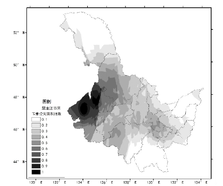
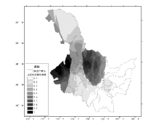
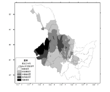
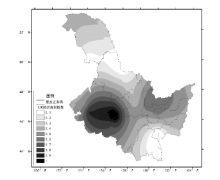
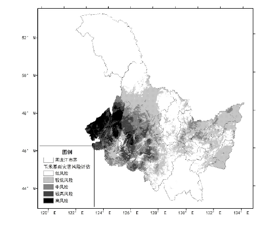
XU Yongqing, LIU Henan, LIU Chunsheng, ZHANG Hongling, JIANG Huiliang. Study on Risk Assessment of Maize Rainstorm and Flood Disaster in Heilongjiang Province[J]. Chinese Agricultural Science Bulletin, 2023, 39(30): 94-100.
Add to citation manager EndNote|Ris|BibTeX
URL: https://www.casb.org.cn/EN/10.11924/j.issn.1000-6850.casb2022-0880

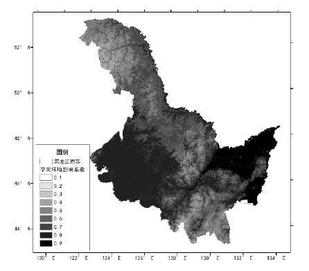
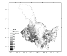
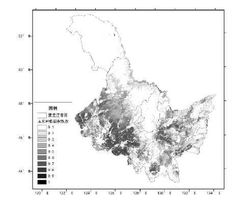
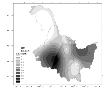
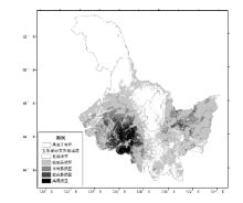
| 一级指标 | 一级指标权重 | 三级指标 | 三级指标权重 |
|---|---|---|---|
| 玉米致灾危险性 指数H | 0.35 | 1 h最大降雨量 | 0.060 |
| 日最大降雨量 | 0.088 | ||
| 过程累计降雨量 | 0.046 | ||
| 暴雨持续日数 | 0.028 | ||
| 地形系数 | 0.077 | ||
| 水系系数 | 0.053 | ||
| 玉米暴露性 指数E | 0.22 | 单位面积产量 | 0.079 |
| 玉米耕种密度 | 0.141 | ||
| 玉米脆弱性 指数V | 0.26 | 经济损失占比 | 0.114 |
| 受灾面积占比 | 0.146 | ||
| 玉米防灾减灾 能力R | 0.17 | 除涝面积 | 0.105 |
| 人均GDP | 0.065 |


| [1] |
张养才, 河维勋, 李世奎. 中国农业气象灾害概论[M]. 北京: 气象出版社, 1991:272-282.
|
| [2] |
杜鹏, 李世奎. 中国农业气象风险评估模型及应用[J]. 气象学报, 1997, 55(1):95-102.
|
| [3] |
陈晓艺, 马哓群, 孙秀邦. 安徽省冬小麦发育期农业干旱发生风险分析[J]. 中国农业气象, 2008, 29(4):472-476.
|
| [4] |
杜尧东, 毛慧勤, 刘锦銮. 华南地区寒害概率分布模型研究[J]. 自然灾害学报, 2003, 12(2):103-107.
|
| [5] |
胡雪琼, 吉文娟, 张茂松, 等. 云南省冬小麦干旱灾损风险区划[J]. 大气科学学报, 2011, 34(3):356-362.
|
| [6] |
王春乙, 王石立, 霍治国, 等. 近10年来中国主要农业气象灾害监测预警与评估技术研究进展[J]. 气象学报, 2005, 63(5):659-671.
|
| [7] |
李娜, 霍治国, 贺楠, 等. 华南地区香蕉、荔枝寒害的气候风险区划[J]. 应用生态学报, 2010, 21(5):1244-1251.
|
| [8] |
刘荣花, 朱自玺, 方文松, 等. 华北平原冬小麦干旱灾损风险区划[J]. 生态学杂志, 2006, 25(9):1068-1072.
|
| [9] |
庞西磊, 黄崇福, 艾福利, 等. 基于信息扩散理论的东北三省农业洪灾风险评估[J]. 中国农学通报, 2012, 28(8):271-275.
|
| [10] |
刘玉英, 石大明, 胡铁鑫, 等. 吉林省农业气象干旱灾害的风险分析及区划[J]. 生态学杂志, 2013, 32(6):1518-1524.
|
| [11] |
任义方, 赵艳霞, 王春乙, 等. 河南省冬小麦干旱保险风险评估与区划[J]. 应用气象学报, 2011, 22(5):537-548.
|
| [12] |
盛绍学, 石磊, 张玉龙, 等. 江淮地区冬小麦渍害指标与风险评估模型研究[J]. 中国农学通报, 2009, 25(19):263-268.
|
| [13] |
王春乙, 张继权, 霍治国, 等. 农业气象灾害风险评估研究进展及展望[J]. 气象学报, 2015, 73(1):1-19.
|
| [14] |
杨舒畅, 申双和. 水稻高温热害及其风险评估的研究进展[J]. 农学学报, 2016, 6(2):122-125.
doi: 10.11923/j.issn.2095-4050.cjas15080004 |
| [15] |
刘佳, 卿清涛, 陈超, 等. 基于热害累计指数的四川单季稻高温热害综合风险评价[J]. 中国生态农业学报(中英文), 2019, 27(9):1440-1452.
|
| [16] |
王祥, 淮建军. 基于三级分层框架的农业气象灾害多风险评估[J]. 自然资源学报, 2020, 35(6):1460-1471.
doi: 10.31497/zrzyxb.20200617 |
| [17] |
United Nations Development Programme. Reducing disaster risk: a challenge for development[J]. John S Swift Co.,USA, 2004:2-4.
|
| [18] |
|
| [19] |
张继权, 冈田宪夫, 多多纳裕一. 综合自然灾害风险管理—全面整合的模式与中国的战略选择[J]. 自然灾害学报, 2006, 15(1):29-37.
|
| [20] |
张继权, 李宁. 主要气象灾害风险评价与管理的数量化方法及其应用[M]. 北京: 北京师范大学出版社, 2013:32-34
|
| [21] |
国家统计局. 中国统计年鉴(2021)[M]. 北京: 中国统计出版社, 2021:235-413.
|
| [22] |
李帅, 陈丽, 王晾晾, 等. 1980年以来黑龙江省玉米低温冷害风险变化研究[J]. 灾害学, 2013, 8(4):100-103.
|
| [23] |
李帅, 王晾晾, 陈莉, 等. 黑龙江省玉米低温冷害风险综合评估模型研究[J]. 自然灾害学报, 2013, 28(4):635-645.
|
| [24] |
杨若子, 周广胜. 东北三省玉米主要农业气象灾害综合危险性评估[J]. 气象学报, 2015, 73(6):1141-1153.
|
| [25] |
王春乙, 蔡菁菁, 张继权, 等. 基于自然灾害风险理论的东北地区玉米干旱、冷害风险评价[J]. 农业工程学报, 2015, 31(6):238-245.
|
| [26] |
高晓容, 王春乙, 张继权, 等. 东北地区玉米主要气象灾害风险评价模型研究[J]. 中国农业科学, 2014, 47(21):4257-4268.
doi: 10.3864/j.issn.0578-1752.2014.21.011 |
| [27] |
黑龙江省统计局. 黑龙江统计年鉴(2021)[M]. 北京: 中国统计出版社, 2021:67-324.
|
| [28] |
章国材. 自然灾害风险评估与区划原理和方法[M]. 北京: 气象出版社, 2013:180-187.
|
| [29] |
徐永清, 陈莉, 刘艳华, 等. 基于不同空间尺度资料的自然灾害风险评估对比分析-以暴雨洪涝灾害为例[J]. 灾害学, 2022, 37(3):61-68.
|
| [1] | YANG Tai, YU Huiying, LU Liming, FU Haiyan, LI Guoliang, DAI Wenlong, LIU Chunguang, YANG Fengshan, MA Yukun. Endophytic Bacteria from Maize Seed with Growth-promoting Potential: Isolation, Identification and Optimization of Fermentation Conditions [J]. Chinese Agricultural Science Bulletin, 2023, 39(9): 16-23. |
| [2] | QIAN Shuanghong, CAI Shikun, ZHU Hanyong, WANG Shaobin, LI Zhengrun, WANG Yingmei, LI Shaoyun. Maize Varieties (Strains) in Different Ecological Regions in Yunnan Province: Analysis of High Yield Potential, Yield Stability and Variety Adaptability [J]. Chinese Agricultural Science Bulletin, 2023, 39(9): 7-15. |
| [3] | HAN Xiaoying, ZHANG Lei, YANG Sanwei, LU Yanzhen, LI Wenting. Fine Regionalization of Climatic Suitability for Sorghum Planting in Shanxi Province Based on GIS [J]. Chinese Agricultural Science Bulletin, 2023, 39(9): 92-99. |
| [4] | SUN Meiting, LI Liangtao, WANG Qian, ZHANG Xiaohua, ZHAO Yanli. Spatial Pattern Analysis of Forest Resources and Key Protected Wild Plants in Qingyazhai National Nature Reserve [J]. Chinese Agricultural Science Bulletin, 2023, 39(8): 27-36. |
| [5] | ZHANG Kexin, YU Xiao, ZHANG Moucao. Effects of Sowing Date on Growth and Yield of Spring Maize in East Gansu [J]. Chinese Agricultural Science Bulletin, 2023, 39(6): 6-12. |
| [6] | YANG Haifeng, HONG Defeng, MA Junfeng, WANG Qun, WEI Xiaoyi. Intercropping of Different Maize Genotypes: Comprehensive Evaluation by DTOPSIS Method [J]. Chinese Agricultural Science Bulletin, 2023, 39(6): 13-17. |
| [7] | YU Chong, ZHANG Fengyun, HUANG Hao, LU Yuncai. Quantitative Genetic Analysis of Cob Correlated Traits in Maize F2 Population [J]. Chinese Agricultural Science Bulletin, 2023, 39(5): 13-20. |
| [8] | HUANG Hao, LU Yuncai. Exogenous Silicon: Effects on Maize and Teosinte Seedlings Under Low Temperature Stress [J]. Chinese Agricultural Science Bulletin, 2023, 39(5): 21-27. |
| [9] | MENG Zhanying, CAI Haixia, YANG Haozhe, WANG Yueqing, GUO Dang, LI Lifeng. Variety Adaptability of Silage Maize in Terms of Photosynthesis and Yield in Western Henan [J]. Chinese Agricultural Science Bulletin, 2023, 39(5): 28-32. |
| [10] | FU Yuhua, MENG Qiuyi, SHANG Kun, LI Xiushi, LIU Fanzhi, LI Xiangdong. SSR Markers of Maize and Sorghum: The Transferability in Adlay [J]. Chinese Agricultural Science Bulletin, 2023, 39(5): 33-38. |
| [11] | YAN Caixia, MIAO Tingting, LIU Junlong, WU Zhongneng, SU Xiaohua, DING Changjun, CAO Zhihua, SUN Hui. The Growth Rhythm and Genetic Variation of the F1 Hybrid Cuttings of Populus deltoids [J]. Chinese Agricultural Science Bulletin, 2023, 39(5): 39-48. |
| [12] | YAN Yini, SHAN Haiyong, LIU Xujie, SHI Xiaoxu, YANG Meiying, LIU Jian. Soybean-maize Belt Composite Planting and Its Application in Jiangsu River Region [J]. Chinese Agricultural Science Bulletin, 2023, 39(30): 1-5. |
| [13] | YANG Hua, JIANG Jufang, DING Wenkui, CHENG Qian, ZHANG Jindan, XU Yufeng. Impacts of High Temperature on Spring Maize Growth in Hexi Area [J]. Chinese Agricultural Science Bulletin, 2023, 39(3): 1-10. |
| [14] | SUN Xijun, LV Shuang, GAO Ying, CAI Miao, MENG Jing, LI Quan. Spatial Variability Characteristics of Cultivated Land Soil pH and Its Dominating Factors in Xi’an City [J]. Chinese Agricultural Science Bulletin, 2023, 39(29): 59-67. |
| [15] | SUN Pei, ZHOU Lingyun, YI Jiewei, ZHANG Chi, WANG Wenwen, YIN Wei. Reserve Cultivated Land Resources and Ecological Risk Assessment in 2021: Taking Danjiangkou City as an Example [J]. Chinese Agricultural Science Bulletin, 2023, 39(29): 68-73. |
| Viewed | ||||||
|
Full text |
|
|||||
|
Abstract |
|
|||||