Welcome to Chinese Agricultural Science Bulletin,
Chinese Agricultural Science Bulletin ›› 2024, Vol. 40 ›› Issue (34): 118-124.doi: 10.11924/j.issn.1000-6850.casb2023-0857
Previous Articles Next Articles
LIU Henan( ), ZHANG Hongling, XU Yongqing, ZHU Hongrui()
Received:2023-12-13
Revised:2024-08-14
Online:2024-12-05
Published:2024-12-03
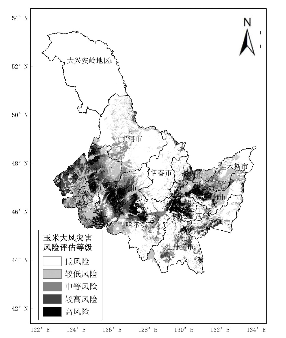
LIU Henan, ZHANG Hongling, XU Yongqing, ZHU Hongrui. Risk Assessment of Gale Disaster on Corn in Heilongjiang Province[J]. Chinese Agricultural Science Bulletin, 2024, 40(34): 118-124.
Add to citation manager EndNote|Ris|BibTeX
URL: https://www.casb.org.cn/EN/10.11924/j.issn.1000-6850.casb2023-0857


| 一级指标 | 一级指标权重 | 二级指标 | 二级指标权重 |
|---|---|---|---|
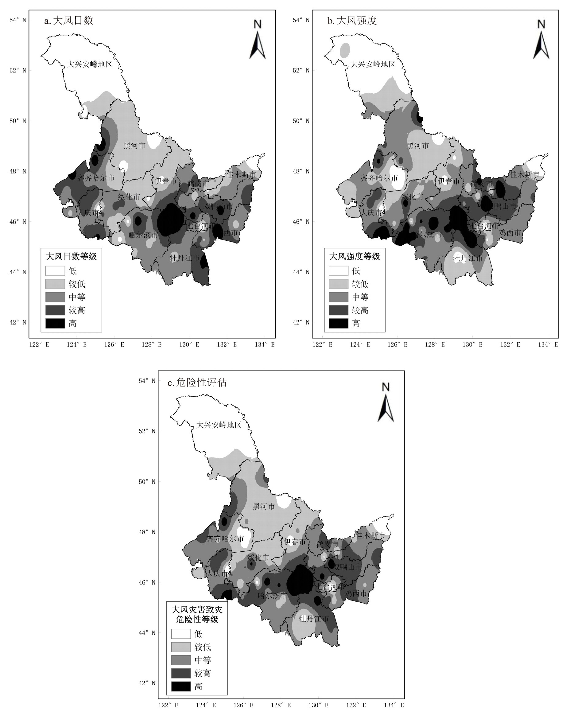
| 致灾危险性指数H | 0.30 | 大风强度 | 0.50 |
| 大风频次 | 0.50 | ||
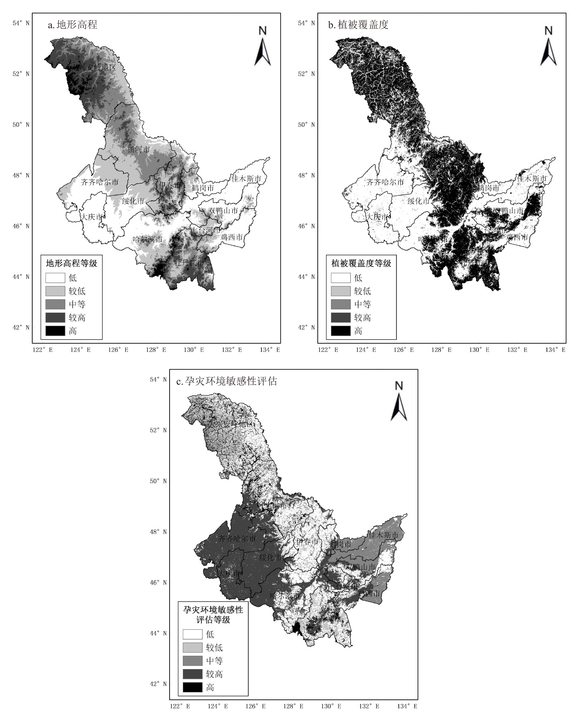
| 孕灾环境影响指数S | 0.26 | 地形高程 | 0.44 |
| 植被覆盖度倒数 | 0.56 | ||
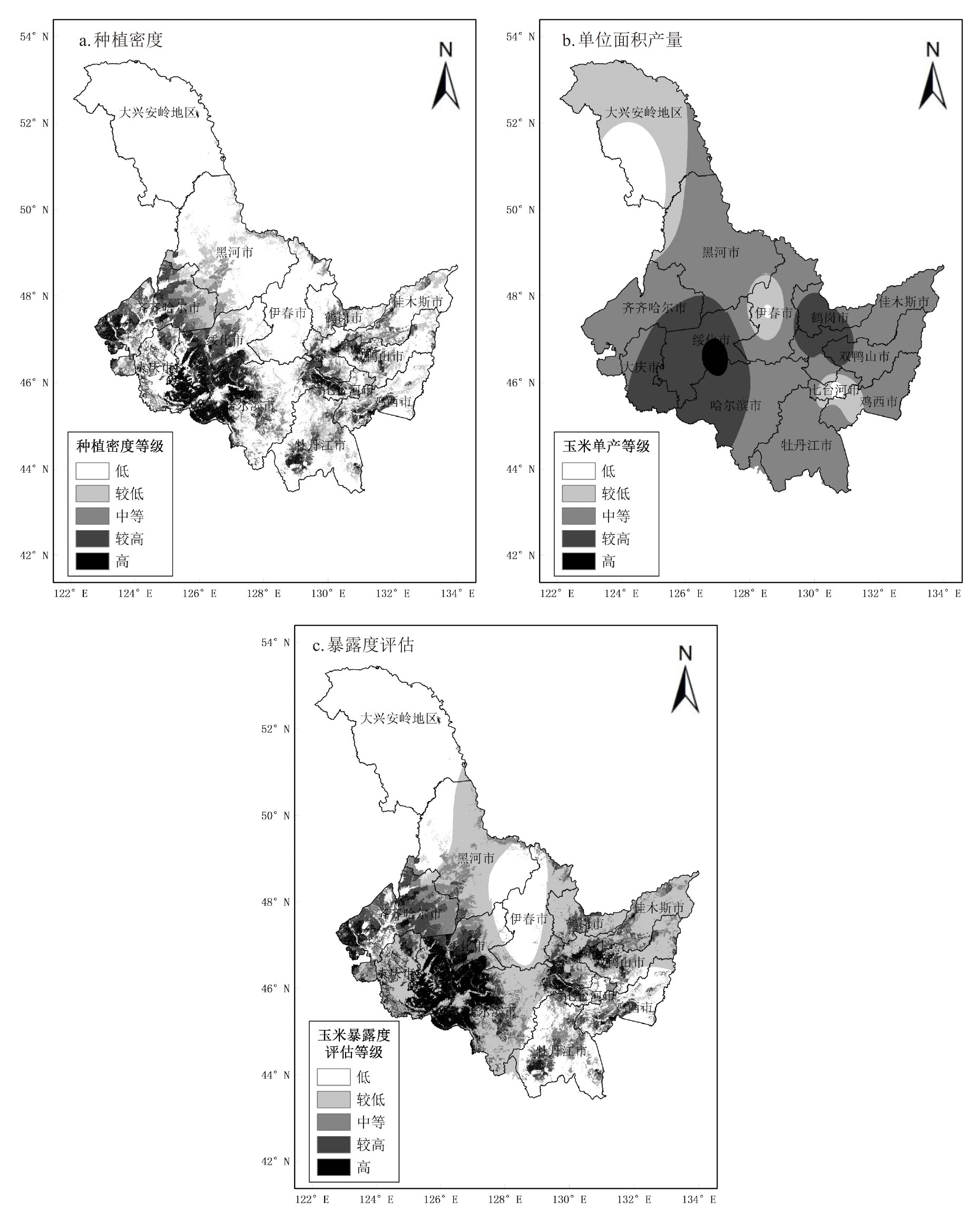
| 承灾体暴露度指数E | 0.24 | 玉米耕种面积 | 0.64 |
| 单位面积产量 | 0.36 | ||
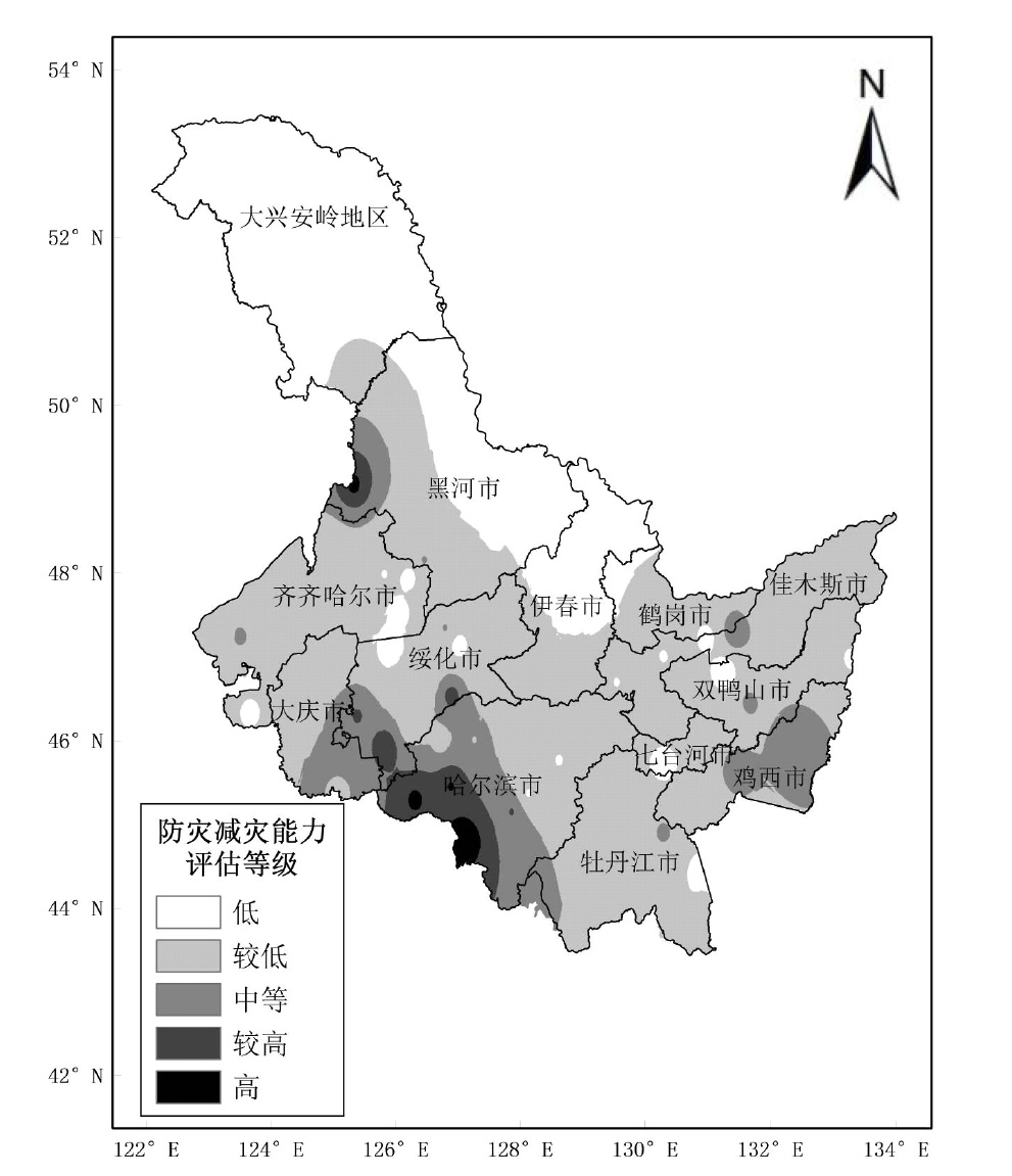
| 防灾减灾能力R | 0.20 | GDP | — |
| 一级指标 | 一级指标权重 | 二级指标 | 二级指标权重 |
|---|---|---|---|
| 致灾危险性指数H | 0.30 | 大风强度 | 0.50 |
| 大风频次 | 0.50 | ||
| 孕灾环境影响指数S | 0.26 | 地形高程 | 0.44 |
| 植被覆盖度倒数 | 0.56 | ||
| 承灾体暴露度指数E | 0.24 | 玉米耕种面积 | 0.64 |
| 单位面积产量 | 0.36 | ||
| 防灾减灾能力R | 0.20 | GDP | — |


| [1] |
中国气象局. 地面气象观测规范[M]. 北京: 气象出版社,2003:132.
|
| [2] |
赵柠, 张礼宝, 王承伟. 黑龙江极端罕见大风天气气象服务浅析[J]. 黑龙江气象, 2021, 38(3):24-26.
|
| [3] |
|
| [4] |
|
| [5] |
|
| [6] |
|
| [7] |
|
| [8] |
|
| [9] |
刘海涛, 刘海红, 韩春光, 等. 南疆大风气候特征分析[J]. 干旱区资源与环境, 2014, 28(3):148-154.
|
| [10] |
姚正毅, 王涛, 周俐, 等. 近40年阿拉善高原大风天气时空分布特征[J]. 干旱区地理, 2006, 29(2):207-212.
|
| [11] |
金巍, 周广胜, 曲岩. 1971—2000年营口地区大风特征及其变化分析[J]. 气候变化研究进展, 2009, 5(4):237-240.
|
| [12] |
李兰, 周月华, 陈波. 湖北省大风灾害及其风险度[J]. 气象科技, 2009, 37(2):205-208.
|
| [13] |
称丛兰, 李青春, 扈海波, 等. 北京地区奥运会间大风灾害的定量评估[J]. 气象科技, 2008, 36(6):806-810.
|
| [14] |
王秋香, 李红军. 新疆近20 a风灾研究[J]. 中国沙漠, 2003, 23(5):546-548.
|
| [15] |
缪霄龙, 缪启龙, 宋健, 等. 杭州地区雷雨大风灾害风险区划[J]. 气象与减灾研究, 2012, 35(3):45-50.
|
| [16] |
张核真. 西藏大风分布特征及风灾区域的初步划分[J]. 西藏科技, 2006(6):40-41.
|
| [17] |
于扬, 倪长健, 沈秋宇, 等. 十二运期间辽宁大风灾害风险评估分析[J]. 中国农学通报, 2014, 30(26):260-265.
|
| [18] |
徐海量, 陈亚宁, 李卫红, 等. 风灾危险性评价—以塔里木盆地为例[J]. 干旱区地理, 2003(3):250-253.
|
| [19] |
张丽娟, 陈红, 高玉宏, 等. 黑龙江省大风分布特征及风险区划研究[J]. 地理科学进展, 2011, 30(7):899-905.
|
| [20] |
任鲁川. 区域自然灾害风险分析研究进展[J]. 地球科学进展, 1999, 14(3):242-246.
|
| [21] |
黄崇福. 自然灾害风险评价理论与实践[M]. 北京: 科学出版社,2005:5-15.
|
| [22] |
章国材. 自然灾害风险评估与区划原理和方法[M]. 北京: 气象出版社,2013:180-187.
|
| [23] |
统计局. 黑龙江统计年鉴-2020[M]. 北京: 中国统计出版社,2020:11-15.
|
| [24] |
亢兴, 梅杰, 王华. 基于数值模式的苏北浅滩海域单站最大风速和极大风速预报方程建立[J]. 海洋预报, 2022, 39(2):34-39.
|
| [25] |
吴素良, 王琦, 张侠, 等. 陕西黄土高原地区日极大风速的统计推算方法[J]. 陕西气象, 2020(2):48-51.
|
| [26] |
陆逸, 朱伟军, 任福民, 等. 1980—2014年中国台风大风和台风极端大风的变化[J]. 气候变化研究进展, 2016, 12(5):413-421.
|
| [27] |
刘赫男, 张洪玲, 朱红蕊, 等. 黑龙江省大风气候特征分析以及致灾危险性区划[J]. 黑龙江气象, 2023, 40(3):6-8.
|
| [28] |
徐永清, 刘赫男, 刘春生, 等. 黑龙江省玉米暴雨洪涝灾害风险评估研究[J]. 中国农学通报, 2023, 39(30):94-100.
doi: 10.11924/j.issn.1000-6850.casb2022-0880 |
| [29] |
任照环, 许伟, 余蜀豫, 等. 重庆市雷电灾害区划[J]. 中国农业资源与区划, 2020, 41(4):317-324.
|
| [1] | CHENG Yujing, WANG Xiaoqiu, GE Lijiao, QIU Liang, ZHAI Caijiao, SONG Xudong, ZHANG Zhenliang, WANG Ximeng. Establishment of Evaluation Model for Eating Quality of Waxy Corn [J]. Chinese Agricultural Science Bulletin, 2024, 40(9): 157-164. |
| [2] | ZHAO Shuzheng, YANG Meili, LU Hongwei, SU Yujie, CHENG Jianmei, WANG Bangtai, QIN Guiwen. Study on the Dynamics of Filament Vigor and Seed Setting of Maize Hybrids [J]. Chinese Agricultural Science Bulletin, 2024, 40(6): 36-41. |
| [3] | YUAN Tao, AN Qi, NIU Yanbo, MENG Liqiang, WU Haoqiong, FAN Chuan, CAO Yabin. Effects of Corn Stalks Composting on Soil Properties of Black Soil Region [J]. Chinese Agricultural Science Bulletin, 2024, 40(5): 47-52. |
| [4] | HUANG Wenyin, LI Jiawei, SONG Zhao, CHANG Jingjing, CHEN Xiao, LI Jing, JIAO Jiabin, ZHANG Baige. Effects of Four Functional Fertilizers on Growth and Quality of Flowering Chinese Cabbage [J]. Chinese Agricultural Science Bulletin, 2024, 40(4): 83-90. |
| [5] | LIANG Haibo, LI Shengdong, LIU Fenghua, CAO Yongchang, WANG Xiangling, XU Yan. Characteristics of Maize Yield and Fertilizer Efficiency in Yellow River Delta Based on Meta Analysis [J]. Chinese Agricultural Science Bulletin, 2024, 40(4): 103-110. |
| [6] | WANG Dan, DU Yanhong, LIU Chuanping, WANG Xiangqin. Study on Remediation Effects of Sedum alfredii Hance and Sweet Corn Intercropping on Cadmium-Polluted Farmland [J]. Chinese Agricultural Science Bulletin, 2024, 40(33): 118-122. |
| [7] | WANG Wenzan, HAN Jian, LI Xin, WANG Chen, LI Ruijuan, YUE Yanjun, ZHANG Lijuan. Effects of New Types of Urea on Yield, Nitrogen Absorption and Utilization, and Production Efficiency of Winter Wheat-Summer Corn Rotation [J]. Chinese Agricultural Science Bulletin, 2024, 40(33): 24-33. |
| [8] | XUE Zhiwei, GAO Feng, HUANG Qingqing, YANG Chunling. Migration Characteristics and Risk Assessment of Heavy Metals in Farmland Soil-Wheat System [J]. Chinese Agricultural Science Bulletin, 2024, 40(30): 48-54. |
| [9] | WU Yitong, LV Chensheng, LIU Yadong, LI Kaiye. Effects of Two Seed Coating on Corn Growth and Antioxidant Defense System of ‘Heinuo 100’ [J]. Chinese Agricultural Science Bulletin, 2024, 40(3): 46-53. |
| [10] | YE Lei, ZHANG Bo, YANG Xuezhen, LI Xiaolin, TAN Wei. Amino Acid Composition and Nutritional Evaluation of Auricularia cornea Cultured with Five Mulberry Sawdust Substrates [J]. Chinese Agricultural Science Bulletin, 2024, 40(3): 135-144. |
| [11] | LI Xingxing, OU Huan, CHEN Juan, LIU Rongsen, TANG Huaijun, XIE Xiaoqing, LIU Yan, LUO Dan. Response to Different Planting Density of Ears Traits and Yield of Spring Sown Maize in Southern Xinjiang [J]. Chinese Agricultural Science Bulletin, 2024, 40(29): 8-13. |
| [12] | CHEN Chang, LIU Xingli, JIANG Lixia, LOU Dejun, WANG Yongchao, ZHU Yumei, LI Yi, LI Wenjing. Study on Relationship Between Meteorological Factors and Grain Crops in Drought-Prone Areas of Songnen Plain from 1971 to 2020 [J]. Chinese Agricultural Science Bulletin, 2024, 40(29): 103-112. |
| [13] | CUI Hanyuan, ZHANG Yue, SONG Zhaowei, CHEN Ying, DING Shu, ZHANG Yuwei, ZHANG Jun, CHEN Xiaoming. Analysis of Research Progress of Purple Corn Anthocyanins [J]. Chinese Agricultural Science Bulletin, 2024, 40(28): 157-164. |
| [14] | ZHAO Ailian, FAN Heqin, YANG Yulong, WEN Tao, LIU Tianxue, ZHAO Xia, YUE Yanjun. Effects of Water and Straw Treatment on Seedling Quality and Yield of Maize [J]. Chinese Agricultural Science Bulletin, 2024, 40(27): 1-6. |
| [15] | WANG Zhenzhen, ZHANG Yuqin, YANG Hengshan, ZHANG Ruifu, JIN Yu, WANG Shuxuan, LU Minyuan. Effects on Dry Matter Accumulation and Transport and Yield of Spring Maize: Nitrogen and Phosphorus Double Removal and Reduction under Shallow Buried Drip Irrigation [J]. Chinese Agricultural Science Bulletin, 2024, 40(27): 7-13. |
| Viewed | ||||||
|
Full text |
|
|||||
|
Abstract |
|
|||||