Welcome to Chinese Agricultural Science Bulletin,
Chinese Agricultural Science Bulletin ›› 2022, Vol. 38 ›› Issue (32): 119-127.doi: 10.11924/j.issn.1000-6850.casb2021-1089
Special Issue: 农业气象
Previous Articles Next Articles
LU Mengyao1( ), LIU Dehu1, LU Xueli1, LIANG Heng1, SUN Yuanyuan1, LIU Yalin1, SONG Tingqiang1(), FAN Haisheng2
Received:2021-11-12
Revised:2022-01-21
Online:2022-11-15
Published:2022-11-09
Contact:
SONG Tingqiang
E-mail:lmy_qust@163.com;songtq@163.com
CLC Number:
LU Mengyao, LIU Dehu, LU Xueli, LIANG Heng, SUN Yuanyuan, LIU Yalin, SONG Tingqiang, FAN Haisheng. Construction of Flood Disaster Risk Assessment Model Based on Principal Component Analysis in Hubei Province[J]. Chinese Agricultural Science Bulletin, 2022, 38(32): 119-127.
Add to citation manager EndNote|Ris|BibTeX
URL: https://www.casb.org.cn/EN/10.11924/j.issn.1000-6850.casb2021-1089
| 24 h降雨量(RD)/mm | 降雨状况 | 降雨等级(RL) |
|---|---|---|
| RD<0.1 | 微量降雨、零星小雨(r1) | 0 |
| 0.1≤RD<10 | 小雨(r2) | 1 |
| 10≤RD<24.9 | 中雨(r3) | 2 |
| 25≤RD<50 | 大雨(r4) | 3 |
| 50≤RD<100 | 暴雨(r5) | 4 |
| 100≤RD<250 | 大暴雨(r6) | 5 |
| RD≥250 | 特大暴雨(r7) | 6 |
| 24 h降雨量(RD)/mm | 降雨状况 | 降雨等级(RL) |
|---|---|---|
| RD<0.1 | 微量降雨、零星小雨(r1) | 0 |
| 0.1≤RD<10 | 小雨(r2) | 1 |
| 10≤RD<24.9 | 中雨(r3) | 2 |
| 25≤RD<50 | 大雨(r4) | 3 |
| 50≤RD<100 | 暴雨(r5) | 4 |
| 100≤RD<250 | 大暴雨(r6) | 5 |
| RD≥250 | 特大暴雨(r7) | 6 |

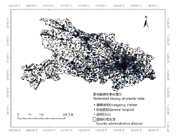
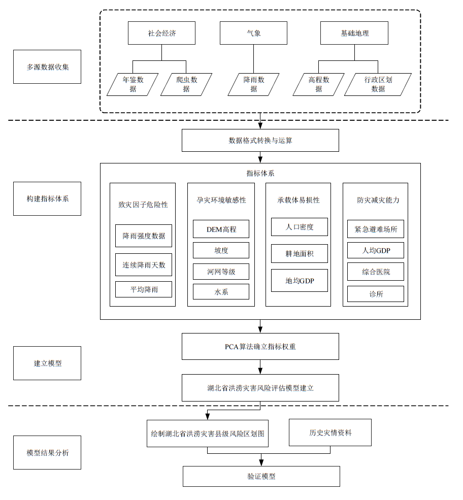
| 洪涝风险 | 指标名称 | 指标简称 |
|---|---|---|
| 致灾因子危险性 | 平均降雨量 | X1 |
| 降雨强度指数 | X2 | |
| 连续降雨天数指数 | X3 | |
| 孕灾环境敏感性 | DEM高程 | X4 |
| 坡度 | X5 | |
| 河网等级指数 | X6 | |
| 水系线长度 | X7 | |
| 水系面积 | X8 | |
| 承灾体易损性 | 人口密度 | X9 |
| 耕地面积 | X10 | |
| 地均GDP | X11 | |
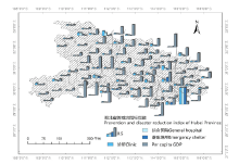
| 防减灾能力 | 紧急避难场所分布数据 | X12 |
| 综合医院分布数据 | X13 | |
| 诊所分布数据 | X14 | |
| 人均GDP | X15 |
| 洪涝风险 | 指标名称 | 指标简称 |
|---|---|---|
| 致灾因子危险性 | 平均降雨量 | X1 |
| 降雨强度指数 | X2 | |
| 连续降雨天数指数 | X3 | |
| 孕灾环境敏感性 | DEM高程 | X4 |
| 坡度 | X5 | |
| 河网等级指数 | X6 | |
| 水系线长度 | X7 | |
| 水系面积 | X8 | |
| 承灾体易损性 | 人口密度 | X9 |
| 耕地面积 | X10 | |
| 地均GDP | X11 | |
| 防减灾能力 | 紧急避难场所分布数据 | X12 |
| 综合医院分布数据 | X13 | |
| 诊所分布数据 | X14 | |
| 人均GDP | X15 |
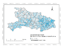
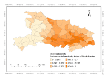
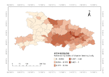
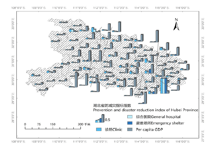
| 目标层 | 准则层 | 权重 | 指标层 | 权重 | 性质 |
|---|---|---|---|---|---|
| 湖北省洪涝灾害风险评估模型 | 致灾因子危险性 | 0.5893427 | 平均降雨量 | 0.7329345 | 正向 |
| 降雨强度指数 | 0.0160338 | 正向 | |||
| 连续降雨天数指数 | 0.2510315 | 正向 | |||
| 孕灾环境敏感性 | 0.2289541 | DEM高程 | 0.5258266 | 负向 | |
| 坡度 | 0.1206974 | 负向 | |||
| 河网等级指数 | 0.2117423 | 正向 | |||
| 水系线长度 | 0.0542571 | 正向 | |||
| 水系面积 | 0.0874765 | 正向 | |||
| 承载体易损性 | 0.1582519 | 人口密度 | 0.7036562 | 正向 | |
| 耕地面积 | 0.2572357 | 正向 | |||
| 地均GDP | 0.0391081 | 正向 | |||
| 防灾减灾能力 | 0.0234512 | 紧急避难场所分布 | 0.6340063 | 负向 | |
| 综合医院分布数据 | 0.0253542 | 负向 | |||
| 诊所分布数据 | 0.3345918 | 负向 | |||
| 人均GDP | 0.0060476 | 负向 |


| 年份 | 受灾地点 | 造成直接经济损失/亿元 |
|---|---|---|
| 2010 | 英山 罗田 广水 江夏 洪湖 嘉鱼 咸宁 赤壁 崇阳 | 211.1 |
| 2011 | 咸宁 荆州 仙桃 武汉 丹江口 | 1137.94 |
| 2012 | 黄陂 鄂西北 郧县 保康 | 45.7 |
| 2013 | 江夏 宣恩 武汉 | 32.3 |
| 2014 | 宣恩 | 38.5 |
| 2015 | 英山 监利 洪湖 仙桃 | 70 |
| 2016 | 江夏 | 816.1 |
| 2017 | 鹤峰 咸宁 | 116.64 |
| 2018 | 宜都 嘉鱼 当阳 | 18.7 |
| [1] | 温泉沛, 周月华, 霍治国, 等. 湖北暴雨洪涝灾害脆弱性评估的定量研究[J]. 中国农业气象, 2018, 39(8):547-557. |
| [2] | 任丙南, 卢海强. 洪涝灾害后区域水环境中污染物迁移转化控制研究[J]. 灾害学, 2021, 36(01):28-31,36. |
| [3] | 邵长秀, 潘学标, 李家文, 等. 不同生育阶段洪涝淹没时长对水稻生长发育及产量构成的影响[J]. 农业工程学报, 2019, 35(3):125-133. |
| [4] |
XU W P, CONG J T, PROVERBS D, et al. An Evaluation of Urban Resilience to Flooding[J]. Water. 2021, 13(15):2022.
doi: 10.3390/w13152022 URL |
| [5] | 赵晓宇, 张凤荣, 李超. 华北低平原农田排水沟平填及洪涝灾害风险分析[J]. 农业工程学报, 2016, 32(7):145-151. |
| [6] |
SAHA A K, AGRAWAL S. Mapping and assessment of flood risk in Prayagraj district, India: a GIS and remote sensing study[J]. Nanotechnology for environmental engineering, 2020, 5(2):11.
doi: 10.1007/s41204-020-00073-1 URL |
| [7] | 杨建莹, 霍治国, 吴立, 等. 西南地区水稻洪涝等级评价指标构建及风险分析[J]. 农业工程学报, 2015, 31(16):135-144. |
| [8] |
ABDO H G. Evolving a total-evaluation map of flash flood hazard for hydro-prioritization based on geohydromorphometric parameters and GIS-RS manner in Al-Hussain river basin, Tartous, Syria[J]. Natural hazards. 2020, 104(1):681-703.
doi: 10.1007/s11069-020-04186-3 URL |
| [9] | 莫建飞, 陆甲, 李艳兰, 等. 基于GIS的广西农业暴雨洪涝灾害风险评估[J]. 灾害学, 2012, 27(1):38-43. |
| [10] | 李柏年. 洪涝灾害评价的威布尔模型[J]. 自然灾害学报, 2005(6):32-36. |
| [11] |
HADIPOUR V, VAFAIE F, DEILAMI K. Coastal Flooding Risk Assessment Using a GIS-Based Spatial Multi-Criteria Decision Analysis Approach[J]. Water. 2020, 12(9):2379.
doi: 10.3390/w12092379 URL |
| [12] | 李莉, 匡昭敏, 莫建飞, 等. 基于AHP和GIS的广西秋旱灾害风险等级评估[J]. 农业工程学报, 2013, 29(19):193-201,293. |
| [13] | QIANG Z, LI L, HUI Q. Flood disaster evaluation based on adaptive fuzzy clustering iterative model and hybrid differential evolution algorithm[J]. Water science & technology water supply, 2019, 19(5-6):1619-1629. |
| [14] |
YANG W C, XU K, LIAN J J, et al. Integrated flood vulnerability assessment approach based on TOPSIS and Shannon entropy methods[J]. Ecological Indicators. 2018, 89:269-280.
doi: 10.1016/j.ecolind.2018.02.015 URL |
| [15] | 刘守强, 武强, 曾一凡, 等. 基于GIS的改进AHP型脆弱性指数法[J]. 地球科学, 2017, 42(4):625-633. |
| [16] | 周月华, 彭涛, 史瑞琴. 我国暴雨洪涝灾害风险评估研究进展[J]. 暴雨灾害, 2019, 38(5):494-501. |
| [17] | 湖北统计年鉴[M]. 北京: 中国统计出版社, 2011-2020. |
| [18] | 吕希希, 张春菊, 黄建伟, 等. 暴雨洪涝敏感性影响因子分析及评估--以江西安义县为例[J]. 灾害学, 2021, 36(1):223-229. |
| [19] |
WU M M, WU Z N, GE W, et al. Identification of sensitivity indicators of urban rainstorm flood disasters: A case study in China[J]. Journal of hydrology. 2021, 599:126393.
doi: 10.1016/j.jhydrol.2021.126393 URL |
| [20] | 曹罗丹, 李加林. 基于遥感与GIS的浙江省洪涝灾害综合风险评估研究[J]. 自然灾害学报, 2015, 24(4):111-119. |
| [21] | 赵华, 李树军, 肖清华, 等. 潍坊市强降雨洪涝灾害风险评估与区划研究[J]. 沙漠与绿洲气象, 2020, 14(6):61-67. |
| [22] | GB/T 28592-2012, 降水量等级[S]. |
| [23] | GB/T 33680-2017, 暴雨灾害等级[S]. |
| [24] | 方德涛. 基于Python爬取POI在城市地理国情监测中的应用[J]. 地理空间信息, 2021, 19(6):79-82,5. |
| [25] | 金慧芳, 史东梅, 陈正发, 等. 基于聚类及PCA分析的红壤坡耕地耕层土壤质量评价指标[J]. 农业工程学报, 2018, 34(7):155-164. |
| [26] |
ABDELAZIZ S, GAD M I, EI TAHAN A. Groundwater quality index based on PCA: Wadi El-Natrun, Egypt[J]. Journal of African earth sciences, 2020, 172(9):103964.
doi: 10.1016/j.jafrearsci.2020.103964 URL |
| [27] | 卞华棋, 王育辉, 王栋, 等. 基于PCA的空战机动高阶重构与评估[J]. 电子测量与仪器学报, 2020, 34(6):191-197. |
| [28] | 黄崇福. 自然灾害风险评价理论与实践[M]. 北京: 科学出版社, 2005. |
| [29] | 李超超, 田军仓, 申若竹. 洪涝灾害风险评估研究进展[J]. 灾害学, 2020, 35(3):131-136. |
| [30] | 田亚平, 向清成, 王鹏. 区域人地耦合系统脆弱性及其评价指标体系[J]. 地理研究, 2013, 32(1):55-63. |
| [31] | 成陆, 付梅臣, 王力. 基于RS和GIS的县域洪涝灾害风险评估[J]. 南水北调与水利科技, 2019, 17(6):37-44,68. |
| [1] | LU Qianqian, FENG Linjiao, WANG Shuang, GULIZHATI·Baoerhan , CHU Ren, ZHOU Long. Effects of Compound Saline-alkali Stress on Physiological and Biochemical Indexes of Table Grapes [J]. Chinese Agricultural Science Bulletin, 2023, 39(1): 62-70. |
| [2] | LIU Cuilan, WANG Kaifang, WU Dejun, YAN Liping, LI Shanwen, WANG Fang, REN Fei, WANG Yinhua. Responses of Growth and Physiological Characteristics of Fraxinus Clones to Coastal Saline-Alkaline Stress [J]. Chinese Agricultural Science Bulletin, 2022, 38(35): 7-16. |
| [3] | YU Zhonghao, ZHOU Wei, LI Zhigang, LI Ziwen, JIA Juanxia, ZHOU Yaxing. Analysis and Comprehensive Evaluation of Main Traits of Soybean in Inner Mongolia from 2002 to 2021 [J]. Chinese Agricultural Science Bulletin, 2022, 38(34): 14-21. |
| [4] | LUO Wei, ZHOU Wei, WANG Zhenguo, LI Yan, YU Wenhao, YANG Zhiqiang, YU Zhonghao, LI Ziwen, ZHOU Yaxing. Twenty-four Sweet Sorghum Materials: Comprehensive Analysis of Main Agronomic Traits and Biological Yield [J]. Chinese Agricultural Science Bulletin, 2022, 38(30): 21-28. |
| [5] | ZHAO Lijuan, ZHI Jiazeng, ZHANG Jianchun, DU Hao, ZHOU Jinsong, LIU Xuemin, ZHANG Rongqin. Diversity Analysis of Leaf Phenotypic Characters of Musa spp. Germplasms [J]. Chinese Agricultural Science Bulletin, 2022, 38(30): 56-64. |
| [6] | WANG Zhiqiang, DU Huiying, LI Cheng, GUO Song, TIAN Mei, YANG Wanbang, YU Rong. Genetic Distance and Heterosis of Quantitative Characters of Watermelon [J]. Chinese Agricultural Science Bulletin, 2022, 38(25): 47-51. |
| [7] | LUO Yulan, ZHANG Guobing, ZHANG Dongmei. Study on Cultivar Classification of Wisteria According Morphological Characteristics [J]. Chinese Agricultural Science Bulletin, 2022, 38(25): 52-59. |
| [8] | LIU Zifan, SU Bimeng, HUANG Jie, WEI Yunxia, XIAO Zili. Effects of Cassava-Peanut Intercropping Patterns on Soil Fertility [J]. Chinese Agricultural Science Bulletin, 2022, 38(25): 102-107. |
| [9] | YAO Xiaojian, ZHANG Xiongjian, YAO Zhufang, LUO Zhongxia, WANG Zhangying, HUANG Lifei, FANG Boping, YANG Yiling. Potted Conservation Substrates of Sweet Potato Germplasms: Screening and Evaluation [J]. Chinese Agricultural Science Bulletin, 2022, 38(24): 28-37. |
| [10] | ZHANG Mengfei, LI Shuang, LI Yunsheng, MA Haixia, LIU Yueqiu. Evaluation on the Drought Resistance of Seedlings of Nine Greening Tree Species [J]. Chinese Agricultural Science Bulletin, 2022, 38(20): 38-46. |
| [11] | LIU Yupeng, ZHANG Hao, CHEN Fang, YU Fei. Effects of Sowing Date on Yield and Quality of Pepper [J]. Chinese Agricultural Science Bulletin, 2022, 38(16): 32-37. |
| [12] | ZHU Mingxia, BAI Ting, JIN Yulong, WANG Shanshan, LIU Xiaojiao, ZHANG Yuhong. Analysis of Flavor Substances of Different Highland Barley Varieties [J]. Chinese Agricultural Science Bulletin, 2022, 38(12): 146-152. |
| [13] | Guo Juncheng, Wang Mingguo, Geng Rong, Li Xin, Yin Xuehong, Wei Guning. Salinity Characteristics Analysis of Saline Alkali Soil in Yinbei Irrigation District of Ningxia [J]. Chinese Agricultural Science Bulletin, 2021, 37(5): 38-42. |
| [14] | Su Xinxin, Xiao Yang, Hu Xiaohang, Ma Yahuai, Li Yanli. The Adaptability Evaluation of Sugar Beet Varieties Based on Grey Relational Analysis and Principal Component Analysis [J]. Chinese Agricultural Science Bulletin, 2021, 37(30): 39-46. |
| [15] | Shan Jianjun, Guan Chongwu, Song Hongqiao, Liu Shijing, Hong Yang, Zhuang Baolu. Evaluation of Damage Caused by Fish Pump Based on Principal Component Analysis [J]. Chinese Agricultural Science Bulletin, 2021, 37(29): 140-145. |
| Viewed | ||||||
|
Full text |
|
|||||
|
Abstract |
|
|||||