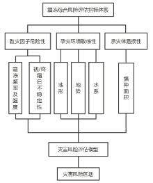
| [1] |
Kotikot S M, Onywere S M . Application of GIS and remote sensing techniques in frost risk mapping for mitigating agricultural losses in the Aberdare ecosystem, Kenya[J]. Geocarto International, 2015,30(1):104-121.
doi: 10.1080/10106049.2014.965758
URL
|
| [2] |
Guan Y, Zheng F, Zhang P , et al. Spatial and temporal changes of meteorological disasters in China during 1950-2013[J]. Natural Hazards, 2015,75(3):2607-2623.
doi: 10.1007/s11069-014-1446-3
URL
|
| [3] |
马树庆, 李锋, 王琪 . 寒潮与霜冻[M]. 北京: 气象出版社, 2009: 67-69.
|
| [4] |
中国气象局气候变化中心. 2018年中国气候变化蓝皮书[M]. 北京, 2018.
|
| [5] |
李洋, 王玉辉, 吕晓敏 , 等. 1961—2013年东北三省极端气候事件时空格局及变化[J]. 资源科学, 2015,37(12):2501-2513.
|
| [6] |
徐风霞, 张珊, 王琪珍 , 等. 寿光1961—2015年初、终霜日、无霜期变化特征及对农业的影响[J]. 中国农学通报, 2019,35(1):112-117.
|
| [7] |
Müller G V, Nuñez M N, Seluchi M E . Relationship between ENSO cycles and frost events within the Pampa Húmeda region[J]. International Journal of Climatology, 2015,20(13):1619-1637.
doi: 10.1002/(ISSN)1097-0088
URL
|
| [8] |
Suzuki Y, Sato S, Kawajiri K . Frost damage and cold damage related to topographic climates in the warm region of Japan[J]. Journal of Agricultural Meteorology, 2010,37(4):289-295.
doi: 10.2480/agrmet.37.289
URL
|
| [9] |
Barlow K M, Christy B P , O’Leary G J, et al. Simulating the impact of extreme heat and frost events on wheat crop production: A review[J]. Field Crops Research, 2015,171:109-119.
doi: 10.1016/j.fcr.2014.11.010
URL
|
| [10] |
郑红, 魏磊, 潘华盛 , 等. 黑龙江终霜日变化特征及对粮食生产影响的分析[J]. 中国农学通报, 2016,32(11):88-94.
|
| [11] |
Micheloud N G, Castro D, Favaro M A , et al. Response of some Citrus species to frost damage at the central area of Santa Fe, Argentina[J]. Revista De La Facultad De Ciencias Agrarias, 2016,48(2):43-56.
|
| [12] |
姚俊英, 于宏敏, 朱红蕊 , 等. 黑龙江省玉米初霜冻致灾临界气象条件风险区划[J]. 中国农学通报, 2012,28(11):312-316.
|
| [13] |
朱红蕊, 刘赫男, 孙爽 , 等. 气候变暖背景下黑龙江省水稻初霜冻灾害风险区划研究[J]. 中国农学通报, 2013,29(30):29-34.
|
| [14] |
王晾晾, 杨晓强, 李帅 , 等. 东北地区水稻霜冻灾害风险评估与区划[J]. 气象与环境学报, 2012,28(5):40.
|
| [15] |
张黎, 尹洪涛, 张国林 . 辽宁西部地区霜冻致灾风险指数特征分析[J]. 中国农学通报, 2015,31(6):204-209.
|
| [16] |
连萍, 王晾晾. 东北三省玉米霜冻灾害风险评估及区划[A].中国气象学会.沈阳第六届雨雪冰冻(霜冻)灾害论坛论文集 [C]. 2012: 26.
|
| [17] |
陈凯奇, 米娜 . 辽宁省玉米低温冷害和霜冻灾害风险评估[J]. 气象与环境学报, 2016,32(1):89-94.
|
| [18] |
任景全, 郭春明, 王丽伟 , 等. 1961—2015年吉林省霜时空分布特征及其影响因素[J]. 气象与环境学报, 2018,34(4):119-125.
|
| [19] |
陈少勇, 郑延祥, 楼望萍 , 等. 中国西北地区初霜冻的气候变化特征[J]. 资源科学, 2013,35(1):165-172.
|
| [20] |
张桂英, 姜秀萍, 周光会 , 等. 气候变暖背景下科尔沁沙地50年霜冻变化分析[J]. 中国农学通报, 2013,29(26):161-164.
|
| [21] |
李芬, 张建新, 武永利 , 等. 近50年山西终霜冻的时空分布及其影响因素[J]. 地理学报, 2013,68(11):1472-1480.
doi: 10.11821/dlxb201311003
URL
|
| [22] |
韩荣青, 李维京, 艾婉秀 , 等. 中国北方初霜冻日期变化及其对农业的影响[J]. 地理学报, 2010,65(5):525-532.
doi: 10.11821/xb201005002
URL
|
| [23] |
吉林省统计局. 2017吉林省统计年鉴[M]. 北京: 中国统计出版社, 2017.
|
| [24] |
章国材 . 气象灾害风险评估与区划方法[M]. 北京: 气象出版社, 2010.
|
| [25] |
严应存, 周秉荣, 陈国茜 , 等. 1961—2010年青海省霜冻灾害变化特征及风险区划[J]. 气象科技, 2015,43(5):986-991.
|
| [26] |
金志凤, 胡波, 严甲真 , 等. 浙江省茶叶农业气象灾害风险评价[J]. 生态学杂志, 2014,33(3):771-777.
|
 ), 胡轶鑫1,*(