Welcome to Chinese Agricultural Science Bulletin,
Chinese Agricultural Science Bulletin ›› 2020, Vol. 36 ›› Issue (3): 74-80.doi: 10.11924/j.issn.1000-6850.casb18080113
Previous Articles Next Articles
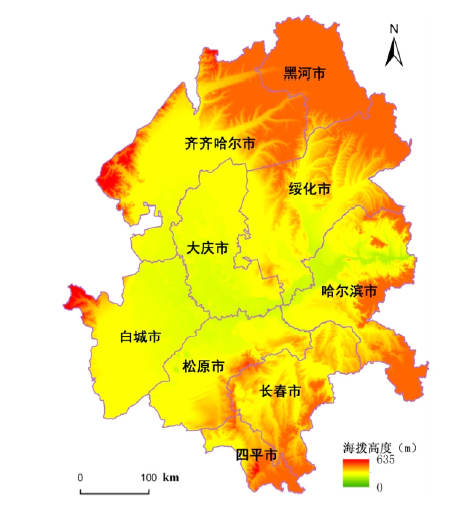
Chen Shanshan, Zang Shuying( ), Sun Li
Received:2018-08-30
Revised:2018-11-02
Online:2020-01-25
Published:2020-01-22
Contact:
Zang Shuying
E-mail:zsy6311@163.com
CLC Number:
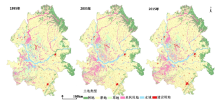
Chen Shanshan, Zang Shuying, Sun Li. Effects of Land Use Change on Habitat Quality Based on InVEST Model: A Case of the Songnen Plain[J]. Chinese Agricultural Science Bulletin, 2020, 36(3): 74-80.
Add to citation manager EndNote|Ris|BibTeX
URL: https://www.casb.org.cn/EN/10.11924/j.issn.1000-6850.casb18080113

| 土地利用类型 | 生境适合性 | 居住地 | 建设用地 | 耕地 | 盐碱地 |
|---|---|---|---|---|---|
| 水田 | 0.5 | 0.3 | 0.3 | 0.3 | 0.1 |
| 旱地 | 0.3 | 0.1 | 0.1 | 1 | 0.2 |
| 有林地 | 1 | 0.8 | 0.9 | 0.6 | 0.2 |
| 灌木林 | 1 | 0.8 | 0.7 | 0.6 | 0.2 |
| 疏林地 | 1 | 0.5 | 0.5 | 0.3 | 0.3 |
| 其它林地 | 1 | 0.2 | 0.5 | 0.1 | 0.1 |
| 草地 | 0.6 | 0.3 | 0.2 | 0.2 | 0.2 |
| 河流 | 1 | 0.9 | 0.9 | 0.7 | 0.3 |
| 水库 | 0.9 | 0.8 | 0.8 | 0.6 | 0.2 |
| 滩地 | 0.6 | 0.1 | 0.3 | 0.2 | 0.2 |
| 城镇用地 | 0 | 0 | 0 | 0 | 0 |
| 农村居民点 | 0 | 0 | 0 | 0 | 0 |
| 工交建设用地 | 0 | 0 | 0 | 0 | 0 |
| 盐碱地 | 0.1 | 0.3 | 0.3 | 0.1 | 1 |
| 沼泽地 | 0.6 | 0.3 | 0.2 | 0.7 | 0.2 |
| 裸地 | 0 | 0 | 0 | 0 | 0 |

| 年代 | 地类 | 林地 | 草地 | 湿地 | 建设用地 | 未利用地 | 耕地 |
|---|---|---|---|---|---|---|---|
| 1995—2005 | 林地 | — | 3.20 | 2.82 | 0.63 | 4.02 | 17.53 |
| 草地 | 4.55 | — | 2.34 | 1.11 | 21.53 | 29.74 | |
| 湿地 | 2.13 | 4.47 | — | 0.76 | 18.42 | 12.86 | |
| 建设用地 | 2.38 | 2.84 | 0.94 | — | 2.75 | 64.67 | |
| 未利用地 | 4.71 | 10.24 | 4.17 | 1.12 | — | 20.57 | |
| 耕地 | 3.80 | 3.11 | 1.08 | 3.55 | 3.30 | — | |
| 2005—2015 | 林地 | — | 0.17 | 0.05 | 0.04 | 0.10 | 0.87 |
| 草地 | 0.15 | — | 0.15 | 0.24 | 0.38 | 3.35 | |
| 湿地 | 0.01 | 0.13 | — | 0.06 | 0.33 | 1.21 | |
| 建设用地 | 0.05 | 0.07 | 0.07 | — | 0.01 | 1.82 | |
| 未利用地 | 0.12 | 1.05 | 0.33 | 0.24 | — | 2.34 | |
| 耕地 | 0.16 | 0.19 | 0.11 | 0.42 | 0.10 | — | |
| 1995—2015 | 林地 | — | 3.31 | 2.86 | 0.67 | 3.96 | 17.69 |
| 草地 | 4.58 | — | 2.36 | 1.30 | 20.95 | 30.93 | |
| 湿地 | 2.17 | 4.33 | — | 0.82 | 18.07 | 13.32 | |
| 建设用地 | 2.38 | 2.81 | 0.98 | — | 2.66 | 63.86 | |
| 未利用地 | 4.68 | 10.60 | 4.25 | 1.32 | — | 21.97 | |
| 耕地 | 3.81 | 3.08 | 1.14 | 3.82 | 3.19 | — |
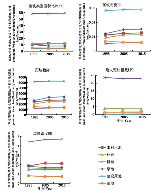
| 年份 | 边界密度 | 平均斑块面积 | 景观形状指数 | 蔓延度指数 | 香农多样性指数 |
|---|---|---|---|---|---|
| 1995 | 0.0733 | 1363.6834 | 70.9570 | 37.0977 | 1.3229 |
| 2005 | 0.0797 | 1255.3314 | 70.9570 | 37.3542 | 1.3016 |
| 2015 | 0.0807 | 1239.3353 | 73.4704 | 37.1769 | 1.3018 |
| 年份 | 边界密度 | 平均斑块面积 | 景观形状指数 | 蔓延度指数 | 香农多样性指数 |
|---|---|---|---|---|---|
| 1995 | 0.0733 | 1363.6834 | 70.9570 | 37.0977 | 1.3229 |
| 2005 | 0.0797 | 1255.3314 | 70.9570 | 37.3542 | 1.3016 |
| 2015 | 0.0807 | 1239.3353 | 73.4704 | 37.1769 | 1.3018 |
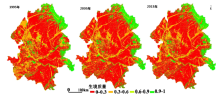

| 评估等级 | 分值区间 | 1995年 | 2005年 | 2015年 | 栅格比例的 变化/% | |||||
|---|---|---|---|---|---|---|---|---|---|---|
| 栅格数/个 | 所占比例/% | 栅格数/个 | 所占比例/% | 栅格数/个 | 所占比例/% | |||||
| 低 | [0,0.3) | 128177 | 59.37 | 134968 | 62.51 | 133254 | 61.72 | 2.35 | ||
| 中 | [0.3,0.6) | 52554 | 24.34 | 46633 | 21.60 | 48326 | 22.38 | -1.96 | ||
| 良好 | [0.6,0.9) | 3924 | 1.82 | 3593 | 1.66 | 3667 | 1.70 | -0.12 | ||
| 优等 | [0.9,1] | 31257 | 14.48 | 30723 | 14.23 | 30670 | 14.20 | -0.27 | ||
| [1] | 殷厚民, 胡建, 王青青 , 等. 松嫩平原西部盐碱土旱作改良研究进展与展望[J]. 土壤通报, 2017,48(1):236-242. |
| [2] | 马驰, 姜琦刚, 陈凤臻 , 等. 松嫩平原土地荒漠化动态监测与分析[J]. 中国环境监测, 2009,25(3):18-22. |
| [3] | 刘兴土 . 松嫩平原退化土地整治与农业发展[M]. 北京: 科学出版社, 2001: 60-135. |
| [4] | 罗玲, 毛德华, 王宗明 , 等. 松嫩平原西部湖泊与水库/坑塘动态变化及驱动因素分析[J]. 农业工程学报, 2015,31(22):285-291. |
| [5] | 钟莉娜, 王军 . 基于InVEST模型评估土地整治对生境质量的影响[J]. 农业工程学报, 2017,33(1):250-255. |
| [6] |
罗娅, 杨胜天, 刘晓燕 .等 . 黄河河口镇-潼关区间1998—2010年土地利用变化特征[J]. 地理学报, 2014,69(1):42-53.
doi: 10.11821/dlxb201401004 URL |
| [7] |
唐柳青, 王其翔, 刘洪军 , 等. 小黑山岛海域刺参、魁蚶和紫贻贝生境适宜性分析[J]. 生态学报, 2017,37(2):668-682.
doi: 10.5846/stxb201507291588 URL |
| [8] |
吴庆明, 王磊, 朱瑞萍 , 等. 基于MAXENT 模型的丹顶鹤营巢生境适宜性分析--以扎龙保护区为例[J]. 生态学报, 2016,36(12):3758-3764.
doi: 10.5846/stxb201410101997 URL |
| [9] |
Wang X L, Dai E F, Zhu J J , et al. Spatial patterns of forest ecosystem services and influencing factors in the Ganjiang river basin[J]. Journal of Resources and Ecology, 2016,7(16):439-452.
doi: 10.5814/j.issn.1674-764x.2016.06.004 URL |
| [10] | 吴健生, 张理卿, 彭建 , 等. 深圳市景观生态安全格局源地综合识别[J]. 生态学报2013, 33(13):4125-4133. |
| [11] |
Polaskv S, Nelson E, Pennington D , et al. The impact of land use change on ecosystem services, biodiversity and returns to landowners: a case study in the state of Minnesota[J]. Environmental and Resource Economics, 2011,48(2):219-242.
doi: 10.1007/s10640-010-9407-0 URL |
| [12] | 褚琳, 黄翀, 刘庆生 , 等. 2000—2010年辽宁省海岸带景观格局与生境质量变化研究[J]. 资源科学, 2015,37(10):1962-1972. |
| [13] |
杨建强, 朱永贵, 宋文鹏 , 等. 基于生境质量和生态响应的莱州湾生态环境质量评价[J]. 生态学报, 2014,34(1):105-114.
doi: 10.5846/stxb201304280850 URL |
| [14] | 陈妍, 乔飞, 江磊 . 基于InVEST模型的土地利用格局变化对区域尺度生境质量的影响研究[J]. 北京大学学报:自然科学版, 2016,52(3):553-562. |
| [15] | Tallis H T, Ricketts T, Nelson E , et al. InVEST3.3.3Beta User's Guide[M]. The Natural Capital Project, Stanford, CA: Stanford University, 2010. |
| [16] |
Lindenmayer D, Hobbs R J, Montague-Drake R , et al. A checklist for ecological management of landscape for conservation[J]. Ecology Letters, 2008,11(1):78-91.
doi: 10.1111/j.1461-0248.2007.01114.x URL pmid: 17927771 |
| [17] | 刘智方, 唐立娜, 邱全毅 , 等. 基于土地利用变化的福建省生境质量时空变化研究[J]. 生态学报, 2017,37(13):1-11. |
| [18] |
吴健生, 毛家颖, 林倩 , 等. 基于生境质量的城市增长边界研究--以长三角地区为例[J]. 地理科学, 2017,37(1):28-36.
doi: 10.13249/j.cnki.sgs.2017.01.004 URL |
| [19] | 吴健生, 曹祺文, 石淑芹 , 等. 基于土地利用变化的京津冀生境质量时空演变[J]. 应用生态学报, 2015,26(11):3457-3466. |
| [20] | 包玉斌, 刘康, 李婷 , 等. 基于InVEST模型的土地利用变化对生境的影响—以陕西省黄河湿地自然保护区为例[J]. 干旱区研究, 2015,32(3):622-629. |
| [1] | SUN Xijun, DENG Rui, LV Shuang, GAO Ying, CAI Miao, GOU Qiaohong, ZHAO Juan. Spatial Variability Characteristics of Farmland Soil Organic Matter in Xi'an [J]. Chinese Agricultural Science Bulletin, 2022, 38(35): 43-53. |
| [2] | TIAN Yutong, HAN Zhiwei, ZHAO Ran, TIAN Yongzhu, LUO Guangfei, YANG Miao. Effects of Typical Land Use Types on Soil Nitrogen Characteristics in Karst Agricultural Areas of Southwest China [J]. Chinese Agricultural Science Bulletin, 2022, 38(33): 89-96. |
| [3] | GAO Lin, HU Jinhao, WANG Zhichao, LIN Changhua, FENG Huimin. Effects of Land Use Change on Ecological Service Value in Mountainous County of Northern Guangdong [J]. Chinese Agricultural Science Bulletin, 2022, 38(32): 69-77. |
| [4] | HAN Wei, XU Shan. Characteristics of Land Use Changes and Ecosystem Service Value in Songnen Plain: A Case Study of Harbin [J]. Chinese Agricultural Science Bulletin, 2022, 38(26): 82-90. |
| [5] | XIE Linxiao, DUAN Yifang, XIAO Chaofei, LI Jinlong. The Coupling Coordination Degree of Land Use Ecology-Society-Economy System in Shandong Province: Spatial-temporal Evolution and Obstacle Factor Analysis [J]. Chinese Agricultural Science Bulletin, 2022, 38(12): 61-68. |
| [6] | ZHANG Ying, YE Baojian, ZHU Zhipeng, YAO Xiong. Terrain Gradient Effects of Land Use Pattern in Fujian Province [J]. Chinese Agricultural Science Bulletin, 2022, 38(11): 96-105. |
| [7] | Lu Weikun, Pang Tao, Yu Lingxiang, Zhang Jiayun. The Influence of Market Economy on Cultivated Land Resources in Planned Tobacco Area of Yunnan [J]. Chinese Agricultural Science Bulletin, 2021, 37(5): 137-142. |
| [8] | Tian Changfeng, Niu Xiong, Yang Qiusheng. Ecological Wisdom and Enlightenment of China’s Agriculture Land Use Planning [J]. Chinese Agricultural Science Bulletin, 2021, 37(26): 146-152. |
| [9] | Ma Heping, Qu Xingle, Wang Jianke, Song Xiaoguang. The Difference of Soil Nutrient Content in the Middle and Upper Reaches of Niyang River Basin of Tibet [J]. Chinese Agricultural Science Bulletin, 2021, 37(25): 103-108. |
| [10] | Ling Jiahui, Liu Hongmei. The Formation of Land Dividends Based on Different Classification Criteria [J]. Chinese Agricultural Science Bulletin, 2021, 37(23): 84-88. |
| [11] | Liang Shijie, Li Liangtao, Zhang Xiaohua, Wang Yao, Zhou Yuekang, Ma Chuanyu. Dynamic Analysis of Landscape Pattern at Village Level in Qingyazhai Reserve: Participatory Interview Based on the 3D e-Sandbox [J]. Chinese Agricultural Science Bulletin, 2021, 37(21): 151-159. |
| [12] | Jiang Yi, Li Zongnan, Dong Xiuchun, Liu Zhongyou, Ren Guoye, Gou Jiesong. Regional Differentiation of Land Use Change Characteristics in Rural Tourism Areas in Sichuan: An Empirical Study Based on Pingle and Suopo Township [J]. Chinese Agricultural Science Bulletin, 2021, 37(15): 158-164. |
| [13] | Liu Yueyang, Du Chong, Gong Wenfeng, Liu Tiedong, Nie Tangzhe, Liu Tao, Cao Kaihua, Xu Chenglong. The Characteristics of Temporal and Spatial Changes of Land Use at County Level Based on Geographical Atlas—Take Youyang Tujia and Miao Autonomous County as an Example [J]. Chinese Agricultural Science Bulletin, 2021, 37(14): 123-135. |
| [14] | Xia Zhengqing, Xie Yanling, Wang Tao. Land Use and Spatial and Temporal Change of Normalized Difference Vegetation Index (NDVI) in Shenfu Mining Area and Their Driving Factors Analysis [J]. Chinese Agricultural Science Bulletin, 2021, 37(14): 97-105. |
| [15] | Sun Lina, Dong Aijing, Gong Yue. Research on Spatial Distribution Optimization of Rural Land Use in Heilongjiang Based on Sansheng Space——Taking Yongxing Town of Mingshui County as an example [J]. Chinese Agricultural Science Bulletin, 2020, 36(35): 156-164. |
| Viewed | ||||||
|
Full text |
|
|||||
|
Abstract |
|
|||||