欢迎访问《中国农学通报》,

中国农学通报 ›› 2021, Vol. 37 ›› Issue (9): 79-84.doi: 10.11924/j.issn.1000-6850.casb2020-0254

所属专题: 资源与环境 耕地保护

• 资源·环境·生态·土壤·气象 • 上一篇    下一篇

漯河市耕地质量等别划分与评价

李志芳1(), 沈新磊2, 王锐1()   

  1. 1河南理工大学测绘与国土信息工程学院,河南焦作 454000
    2漯河市土壤肥料站,河南漯河 462300
  • 收稿日期:2020-07-13 修回日期:2020-09-20 出版日期:2021-03-25 发布日期:2021-04-09
  • 通讯作者: 王锐
  • 作者简介:李志芳,女,1995年出生,山西阳城人,硕士研究生,研究方向:耕地质量评价。通信地址:454000 河南省焦作市山阳区世纪大道2001号 河南理工大学,Tel:0391-3987661,E-mail: 18634663791@163.com
  • 基金资助:
    国家自然科学基金资助项目“基于氢氧稳定同位素的黄土塬区地下水补给机制研究”(41101025);“豫东南地区气候变化的耕地利用适应策略及实施效应”(U1504401);河南省高等学校重点科研项目“基于氢氧稳定同位素黄淮海平原典型灌区冬小麦水分利用策略研究”(15A210009)

Classification and Evaluation of Cultivated Land Quality in Luohe City

Li Zhifang1(), Shen Xinlei2, Wang Rui1()   

  1. 1School of Surveying and Land Information Engineering, Henan Polytechnic University, Jiaozuo Henan 454000
    2Luohe City Soil and Fertilizer Station, Luohe Henan 462300
  • Received:2020-07-13 Revised:2020-09-20 Online:2021-03-25 Published:2021-04-09
  • Contact: Wang Rui

摘要:

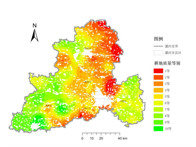
为分析不同等别耕地的数量特征、空间分布及限制因素,制定针对性耕地保护措施,以河南省漯河市为研究区域,选取17个评价指标构建耕地质量综合评价体系,并借助层次分析法和隶属函数法确定各指标权重值和隶属度,计算耕地质量综合指数,按照自然断点法划分耕地质量等别并分析。结果表明:(1)漯河市耕地质量等别大致呈东北向西南递减,其中临颍县、郾城区、源汇区以及召陵区大部分地区的耕地质量较高,舞阳县西南部及召陵区北部耕地质量相对较差;(2)漯河市优等地、高等地、中等地、低等地占比分别为12.48%、39.28%、38.58%、9.67%,耕地质量水平有待进一步提高;(3)针对漯河市各区域耕地质量存在土壤养分状况、农田基础建设、土壤障碍因子等不同的主要限制性因素,实施相应改善措施。该研究为漯河市加强耕地质量建设、增强农业生产能力提供了有效参考。

关键词: 耕地质量, 指标体系, 层次分析, 等别划分, 综合评价, 保护措施

Abstract:

To analyze the quantitative characteristics, spatial distribution and limiting factors of different types of cultivated land in Luohe City, Henan Province, and put forward specific protection measures, a comprehensive evaluation system with 17 selected indexes was constructed. By means of analytic hierarchy process and membership function method, the weight value and membership degree of each index were studied. The authors calculated the comprehensive indexes and grades according to natural breakpoint method. The results showed that: (1) the quality of cultivated land decreased from northeast to southwest in Luohe City, among which the quality of cultivated land in Linying County, Yancheng District, Yuanhui District and most of Zhaoling District was relatively high, and the quality of cultivated land in southwest Wuyang County and northern Zhaoling District was relatively poor; (2) the proportion of superior land, higher land, middle land and lower land in Luohe City was 12.48%, 39.28%, 38.58% and 9.67%, respectively, and the quality level of cultivated land needs to be further improved; (3) according to the main restrictive factors such as soil nutrient status, farmland infrastructure construction and soil barrier factors, the corresponding improvement measures were implemented. This study provides effective references for strengthening cultivated land quality construction and enhancing agricultural production capacity in Luohe City.

Key words: cultivated land quality, indicator system, hierarchical analysis, classification, comprehensive evaluation, protection measures

中图分类号: