欢迎访问《中国农学通报》,
中国农学通报 ›› 2022, Vol. 38 ›› Issue (11): 89-95.doi: 10.11924/j.issn.1000-6850.casb2021-0962
古丽娜尔·索尔达汗1( ), 李晓燕1(), 石振宇1, 邢梓涵2, 吴海涛3
收稿日期:2021-10-11
修回日期:2021-12-19
出版日期:2022-04-15
发布日期:2022-05-18
通讯作者:
李晓燕
作者简介:古丽娜尔·索尔达汗,女,1993年出生,新疆乌鲁木齐人,在读硕士,研究方向:城市化进程对环境的影响。通信地址:130012 吉林省长春市建设街2199号 吉林大学地球科学学院,Tel:0431-88502123,E-mail: 基金资助:
Gulinaer ·Suoerdahan1(), LI Xiaoyan1(), SHI Zhenyu1, XING Zihan2, WU Haitao3
Received:2021-10-11
Revised:2021-12-19
Online:2022-04-15
Published:2022-05-18
Contact:
LI Xiaoyan
摘要:
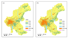
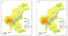
通过分析长春市区建设用地与耕地的时空变化特征及建设用地扩张对耕地的影响,为黑土区土地合理利用与耕地保护提供参考。本文采用2005年和2019年的Landsat TM/OLI遥感影像,基于面向对象-决策树的分类方法提取研究区土地利用信息,对长春市区建设用地和耕地的时空变化及建设用地对耕地数量、质量和结构的影响进行了研究。结果表明:2005年以来,长春市区建设用地扩张21163.30 hm2,而耕地面积则减少19011.81 hm2。新增加的建设用地占用耕地18170.84 hm2,为建设用地增加面积的85.33%,建设用地的扩张导致耕地破碎化程度增大;建设用地侵占的耕地多为优质耕地,Ⅰ~Ⅲ级的面积比例达72.17%。研究结果对协调黑土区快速城市化过程中耕地资源的保护具有重要的指导意义。
中图分类号:
古丽娜尔·索尔达汗, 李晓燕, 石振宇, 邢梓涵, 吴海涛. 长春市建设用地扩张对耕地资源的影响[J]. 中国农学通报, 2022, 38(11): 89-95.
Gulinaer ·Suoerdahan, LI Xiaoyan, SHI Zhenyu, XING Zihan, WU Haitao. The Impact of Construction Land Expansion on Arable Land Resources in Changchun[J]. Chinese Agricultural Science Bulletin, 2022, 38(11): 89-95.

| 指标 | 定义 | 公式 | 生态意义 | 尺度水平 |
|---|---|---|---|---|
| 最大斑块占景观面积比例(LPI) | 最大斑块占景观总面积的百分比 | | 表征景观的优势度,反应人类活动的方向和强弱 | 类型水平/景观水平 |
| 景观形状指标(LSI) | 某一斑块形状与相同面积的形状(圆或正方形)之间的偏离程度 | | 表现出景观斑块形状的复杂性 | 类型水平/景观水平 |
| 面积加权平均形状指标(AWMSI) | 斑块的周长/面积比乘以面积权重之后的总和 | | 度量景观空间格局复杂性 | 类型水平/景观水平 |
| 斑块结合度(COHESION) | 反映斑块的物理连通性 | | 表征给定距离阈值内景观类型的连接程度 | 类型水平/景观水平 |
| 分离度(SPLIT) | 某一景观类型中不同斑块个体分布的分离程度 | | 表征景观被分割的破碎程度 | 类型水平/景观水平 |
| 聚集度(AI) | 计算不同类型斑块间的相邻矩阵来描述不同斑块间的聚集程度 | | 表征景观连通性和破碎化程度 | 类型水平/景观水平 |
| 类型 | 2005年 | 2019年 | 变化/hm2 | |||
|---|---|---|---|---|---|---|
| 面积/hm2 | 占比/% | 面积/hm2 | 占比/% | |||
| 建设用地 | 91149.08 | 12.64 | 112312.38 | 15.57 | 21163.30 | |
| 耕地 | 463255.58 | 64.22 | 444243.77 | 61.59 | -19011.81 | |
| 类型 | 2005年 | 2019年 | 变化/hm2 | |||
|---|---|---|---|---|---|---|
| 面积/hm2 | 占比/% | 面积/hm2 | 占比/% | |||
| 建设用地 | 91149.08 | 12.64 | 112312.38 | 15.57 | 21163.30 | |
| 耕地 | 463255.58 | 64.22 | 444243.77 | 61.59 | -19011.81 | |

| 2005年 | 2019年 | |||||
|---|---|---|---|---|---|---|
| 耕地 | 林地 | 草地 | 湿地 | 建设用地 | 其他 | |
| 耕地 | 443965.19 | 983.31 | 0.00 | 67.61 | 18170.84 | 68.63 |
| 林地 | 88.31 | 133055.80 | 0.00 | 69.01 | 2624.72 | 125.88 |
| 草地 | 30.40 | 15.33 | 160.74 | 0.00 | 120.50 | 0.00 |
| 湿地 | 62.94 | 166.35 | 0.00 | 29358.06 | 323.95 | 29.65 |
| 建设用地 | 88.69 | 37.28 | 0.00 | 0.00 | 91017.25 | 5.85 |
| 其他 | 8.24 | 2.59 | 0.00 | 8.69 | 55.12 | 620.73 |
| 景观格局指数 | 耕地 | 建设用地 | |||
|---|---|---|---|---|---|
| 2005 | 2019 | 2005 | 2019 | ||
| LPI/% | 59.52 | 37.14 | 5.85 | 7.65 | |
| LSI | 38.19 | 38.33 | 40.40 | 39.42 | |
| AWMSI | 32.75 | 23.18 | 6.19 | 7.28 | |
| COHESION/% | 99.78 | 99.48 | 91.99 | 93.85 | |
| SPLIT/% | 2.82 | 5.67 | 89.85 | 69.95 | |
| AI/% | 77.80 | 77.42 | 47.65 | 52.42 | |

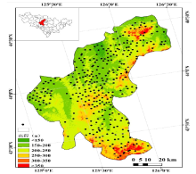
| 土壤质量等级 | 土壤质量指数 | 耕地 | |
|---|---|---|---|
| 面积/hm2 | 占比/% | ||
| Ⅰ | > 0.50 | 66454.44 | 14.35 |
| Ⅱ | 0.46~0.50 | 113856.47 | 24.58 |
| Ⅲ | 0.42~0.46 | 158711.52 | 34.26 |
| Ⅳ | 0.39~0.42 | 79411.29 | 17.14 |
| Ⅴ | <0.39 | 44821.86 | 9.68 |
| 土壤质量等级 | 土壤质量指数 | 耕地 | |
|---|---|---|---|
| 面积/hm2 | 占比/% | ||
| Ⅰ | > 0.50 | 66454.44 | 14.35 |
| Ⅱ | 0.46~0.50 | 113856.47 | 24.58 |
| Ⅲ | 0.42~0.46 | 158711.52 | 34.26 |
| Ⅳ | 0.39~0.42 | 79411.29 | 17.14 |
| Ⅴ | <0.39 | 44821.86 | 9.68 |
| 土壤质量等级 | 建设占用耕地 | 中心城区 | 双阳区 | 九台区 | |||||||
|---|---|---|---|---|---|---|---|---|---|---|---|
| 面积/hm2 | 占比/% | 面积/hm2 | 占比/% | 面积/hm2 | 占比/% | 面积/hm2 | 占比/% | ||||
| Ⅰ | 1970.03 | 10.84 | 1946.50 | 17.31 | 11.16 | 0.30 | 12.61 | 0.39 | |||
| Ⅱ | 6588.45 | 36.26 | 6159.89 | 54.79 | 207.30 | 5.57 | 221.02 | 6.90 | |||
| Ⅲ | 4555.40 | 25.07 | 2544.44 | 22.63 | 848.39 | 22.78 | 1162.37 | 36.28 | |||
| Ⅳ | 4427.67 | 24.37 | 591.55 | 5.26 | 2575.40 | 69.15 | 1260.81 | 39.35 | |||
| Ⅴ | 629.28 | 3.46 | — | — | 82.09 | 2.20 | 547.32 | 17.08 | |||
| [1] | 崔宁波, 赵端阳, 王胜男. 加强黑土地保护保障国家粮食安全[J]. 奋斗, 2021(4):33-35. |
| [2] |
LI H D, SHI W J, WANG B, et al. Comparison of the modeled potential yield versus the actual yield of maize in Northeast China and the implications for national food security[J]. Food Security, 2017, 9:99-114.
doi: 10.1007/s12571-016-0632-4 URL |
| [3] |
WU Y Z, ZHANG X L, SHEN L Y. The impact of urbanization policy on land use change:A scenario analysis[J]. Cities, 2010, 28(2):147-159.
doi: 10.1016/j.cities.2010.11.002 URL |
| [4] | 田逸飘, 郭佳钦, 廖望科. 我国城镇化进程的驱动因素分解及阶段性变化基于LMDI模型的再检验[J/OL]. 生态经济, 2021, 37(7):1-12. |
| [5] |
BAI X M, SHI P J, LIU Y S. Society:Realizing China's urban dream[J]. Nature, 2014, 509(7499):158-160.
doi: 10.1038/509158a URL |
| [6] |
李广东, 戚伟. 中国建设用地扩张对景观格局演化的影响[J]. 地理学报, 2019, 74(12):2572-2591.
doi: 10.11821/dlxb201912011 |
| [7] | 黄季焜, 朱莉芬, 邓祥征. 中国建设用地扩张的区域差异及其影响因素[J]. 中国科学(D辑):地球科学, 2007, 37(9):1235-1241. |
| [8] | 李晓江, 尹强, 张娟, 等. 《中国城镇化道路、模式与政策》研究报告综述[J]. 城市规划学刊, 2014(2):1-14. |
| [9] | 任晓燕, 何艳芬, 王宗明. 基于遥感的辽中南城市群建设用地扩张及其占用耕地的时空特征[J]. 国土资源遥感, 2020, 32(3):98-105. |
| [10] |
JU H R, ZHANG Z X, ZHAO X L, et al. The changing patterns of cropland conversion to built-up land in China from 1987 to 2010[J]. Journal of Geographical Sciences, 2018, 28(11):1595-1610.
doi: 10.1007/s11442-018-1531-8 URL |
| [11] | 范泽孟, 李赛博. 1990年来中国城镇建设用地占用耕地的效率和驱动机理时空分析[J]. 生态学报, 2021, 41(1):374-387. |
| [12] | 黄宝荣, 张慧智, 宋敦江, 等. 2000-2010年中国大陆地区建设用地扩张的驱动力分析[J]. 生态学报, 2017, 37(12):4149-4158. |
| [13] |
YOU H Y, HU X W, WU Y H. Farmland use intensity changes in response to rural transition in Zhejiang province, China[J]. Land Use Policy, 2018, 79:350-361.
doi: 10.1016/j.landusepol.2018.08.029 URL |
| [14] | 孟祥凤, 王冬艳, 李红, 等. 典型黑土区建设占用耕地的时空配置效率研究[J]. 资源开发与市场, 2017, 33(8):948-953,911. |
| [15] | 李子瑞, 姜博, 张余, 等. 东北三省新型城镇化与耕地集约利用协调性评价与预测[J]. 水土保持研究, 2021, 28(6):260-267. |
| [16] | 张浩, 冯淑怡, 曲福田. 耕地保护、建设用地集约利用与城镇化耦合协调性研究[J]. 自然资源学报, 2017, 32(6):1002-1015. |
| [17] | 汪雨琴, 余敦, 刘庆芳. 基于脱钩理论的九江县建设占用耕地与经济增长关系研究[J]. 中国农业资源与区划, 2017, 38(08):35-38,54. |
| [18] | 王宗明, 张柏, 张树清. 吉林省近20年土地利用变化及驱动力分析[J]. 干旱区资源与环境, 2004, 18(6):61-65. |
| [19] | 邹亮, 窦衍光, 胡睿, 等. 青岛古镇口创新示范区土地质量评价及规划利用[J]. 海洋地质前沿, 2021, 37(9):49-59. |
| [20] | 张利权, 甄彧. 上海市景观格局的人工神经网络(ANN)模型[J]. 生态学报, 2005(5):958-964. |
| [21] |
LI X Y, LI H Y, YANG L M, et al. Assessment of soil quality of croplands in the Corn Belt of Northeast China[J]. Sustainability, 2018, 10(1):248.
doi: 10.3390/su10010248 URL |
| [22] |
SUN B, ZHOU S L, ZHAO Q G. Evaluation of spatial and temporal changes of soil quality based on geostatistical analysis in the hill region of subtropical China[J]. Geoderma, 2003, 115(1):85-99.
doi: 10.1016/S0016-7061(03)00078-8 URL |
| [23] | 唐秀美, 陈百明, 路庆斌, 等. 城市边缘区土地利用景观格局变化分析[J]. 中国人口·资源与境, 2010, 20(8):159-163. |
| [24] | 叶振宇. 东北地区经济发展态势与新一轮振兴[J]. 区域经济评论, 2015(6):61-67. |
| [25] |
樊杰, 刘汉初, 王亚飞, 等. 东北现象再解析和东北振兴预判研究---对影响国土空间开发保护格局变化稳定因素的初探[J]. 地理科学, 2016, 36(10):1445-1456.
doi: 10.13249/j.cnki.sgs.2016.10.001 |
| [26] | KUANG W H, LIU J Y, DONG J W, et al. The repid and massive urban and industrial land expansions in China between 1990 and 2010:A CLUD-based analysis of their trajectories, patterns, and drivers[J]. Landscape and Urban Planning,2016, 145:211-33. |
| [27] |
LI X Y, YANG L M, REN Y X, et al. Impacts of urban sprawl on soil resources in the Changchun-Jilin economic zone,China, 2000-2015[J]. International Journal of Environmental Research and Public Health, 2018, 15(6):1186.
doi: 10.3390/ijerph15061186 URL |
| [28] |
程维明, 高晓雨, 马廷, 等. 基于地貌分区的1990-2015年中国耕地时空特征变化分析[J]. 地理学报, 2018, 73(9):1613-1629.
doi: 10.11821/dlxb201809001 |
| [29] | 任庆陆. 城乡一体化交通运输发展[J]. 中小企业管理与科技(下旬刊), 2021, 4(4):118-119. |
| [30] |
张慧, 王洋. 中国耕地压力的空间分异及社会经济因素影响:基于342个地级行政区的面板数据[J]. 地理研究, 2017, 36(4):731-742.
doi: 10.11821/dlyj201704011 |
| [31] |
DENG X Z, HUANG J K, ROZELLE S, et al. Impact of urbanization on cultivated land changes in China[J]. Land Use Policy, 2015, 45:1-7.
doi: 10.1016/j.landusepol.2015.01.007 URL |
| [32] | 赵德恒. 建设用地与耕地时空演变及博弈机制研究[D]. 烟台: 鲁东大学, 2019:1-52. |
| [33] | 宁静, 郭磊, 赵超越, 等. 2001-2017年哈尔滨市建设用地扩张时空特征分析[J]. 科学技术与工程, 2020, 20(31):12948-12954. |
| [34] | 张海龙, 蒋建军, 解修平, 等. 近25年来西安地区土地利用变化及驱动力研究[J]. 资源科学, 2006, 30(4):71-77. |
| [35] | 许利洋, 买尔哈巴·玉苏甫.潜江市耕地格局与景观破碎化研究[J]. 湖北农业科学, 2020, 59(14):30-36. |
| [36] | 葛玉娟, 赵宇鸾, 任红玉. 山区耕地细碎化对不同利用方式农地集约度的影响[J]. 地球科学进展, 2020, 35(2):180-188. |
| [37] | 付刚, 肖能文, 乔梦萍, 等. 北京市近二十年景观破碎化格局的时空变化[J]. 生态学报, 2017, 37(8):2551-2562. |
| [1] | 丁琪洵, 汤萌萌, 李子杰, 江文娟, 张学伟, 马友华. 涡阳县高标准农田耕地质量等级评价研究[J]. 中国农学通报, 2022, 38(4): 46-52. |
| [2] | 孙喜军, 邓睿, 吕爽, 高莹, 蔡苗, 缑巧红, 赵娟. 西安市农用地土壤有机质空间变异特征[J]. 中国农学通报, 2022, 38(35): 43-53. |
| [3] | 卢梦瑶, 刘德虎, 鲁雪丽, 梁衡, 孙媛媛, 刘亚林, 宋廷强, 范海生. 基于主成分分析的湖北省洪涝灾害风险评估模型构建[J]. 中国农学通报, 2022, 38(32): 119-127. |
| [4] | 张慧敏, 鲍广灵, 周晓天, 高琳琳, 胡宏祥, 马友华. 严格管控类耕地特定农作物重金属安全性评估[J]. 中国农学通报, 2022, 38(3): 52-58. |
| [5] | 姜玉琴, 谢先进, 黄达. 耕地质量对耕地生产力的影响[J]. 中国农学通报, 2022, 38(3): 75-80. |
| [6] | 潘雪, 蔡立群, 董博, 乜光昀. 平川区耕地质量等级及养分特征分析研究[J]. 中国农学通报, 2022, 38(29): 118-128. |
| [7] | 胡一, 王晶, 李刚. 渭北旱塬土地整治新增耕地土壤养分特征及肥力等级评价——以合阳县为例[J]. 中国农学通报, 2022, 38(27): 94-100. |
| [8] | 权胜祥, 史学峰, 刘晓月, 李昌武, 葛燚, 张燕. 可降解螯合剂强化籽粒苋修复镉污染耕地的研究[J]. 中国农学通报, 2022, 38(25): 85-89. |
| [9] | 桂苗, 汪甜甜, 马友华. 合肥市农田土壤质地空间特征分析与耕地质量提升[J]. 中国农学通报, 2022, 38(25): 114-119. |
| [10] | 邓婷, 吴家龙. 耕地土壤酸化现状及治理路径探析——以广东省为例[J]. 中国农学通报, 2022, 38(24): 70-74. |
| [11] | 骆美, 郭龙, 费坤, 张天恩, 李陈, 马友华. 耕地质量提升技术及其应用[J]. 中国农学通报, 2022, 38(21): 76-81. |
| [12] | 索龙, 王鹏, 张俊丽, 景鹏娟, 李建宏, 董晓梅, 拜翊莎, 曹红霞, 李康, 赵晓进. 陕西省畜禽粪尿养分资源及耕地负荷分析[J]. 中国农学通报, 2022, 38(20): 117-123. |
| [13] | 张羽丰, 孙江涛, 李青松, 范利瑶, 文倩. 豫东农区农户宅基地退出意愿及影响因素分析——以扶沟县为例[J]. 中国农学通报, 2022, 38(2): 150-156. |
| [14] | 佟帆, 魏琳, 刘绪军, 任宪平, 李志飞, 王平, 郝燕芳. 东北黑土区植被配置的土壤抗冲性研究[J]. 中国农学通报, 2022, 38(2): 44-51. |
| [15] | 厉雅华, 张向前, 安祺, 武迪, 刘战勇, 孙峰, 张德健, 高敏, 张国英, 邢俊. 耕地地力评价方法及实践应用研究进展[J]. 中国农学通报, 2022, 38(15): 60-68. |
| 阅读次数 | ||||||
|
全文 |
|
|||||
|
摘要 |
|
|||||