欢迎访问《中国农学通报》,
中国农学通报 ›› 2023, Vol. 39 ›› Issue (23): 30-38.doi: 10.11924/j.issn.1000-6850.casb2022-0873
李晓青1( ), 吴琳1(), 何长元2
收稿日期:2022-10-13
修回日期:2022-12-25
出版日期:2023-08-15
发布日期:2023-08-10
作者简介:李晓青,女,1963年出生,湖南湘潭人,副教授,硕士,研究方向:资源利用与区域规划。通信地址:410081 湖南师范大学地理科学学院,E-mail:liixiaoqing1919@foxmail.com。
基金资助:
LI Xiaoqing1(), WU Lin1(), HE Changyuan2
Received:2022-10-13
Revised:2022-12-25
Published:2023-08-15
Online:2023-08-10
摘要:
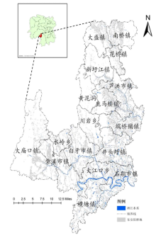
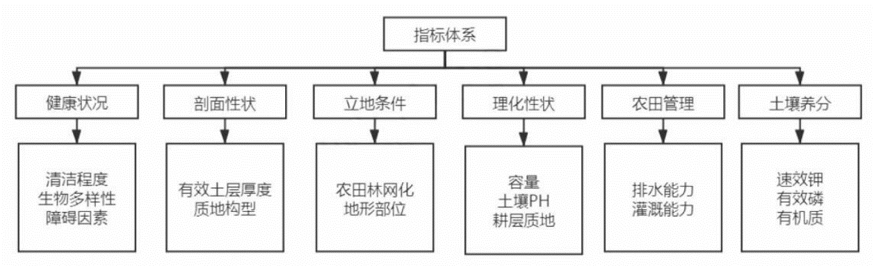
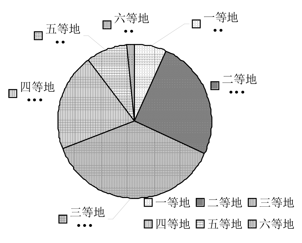
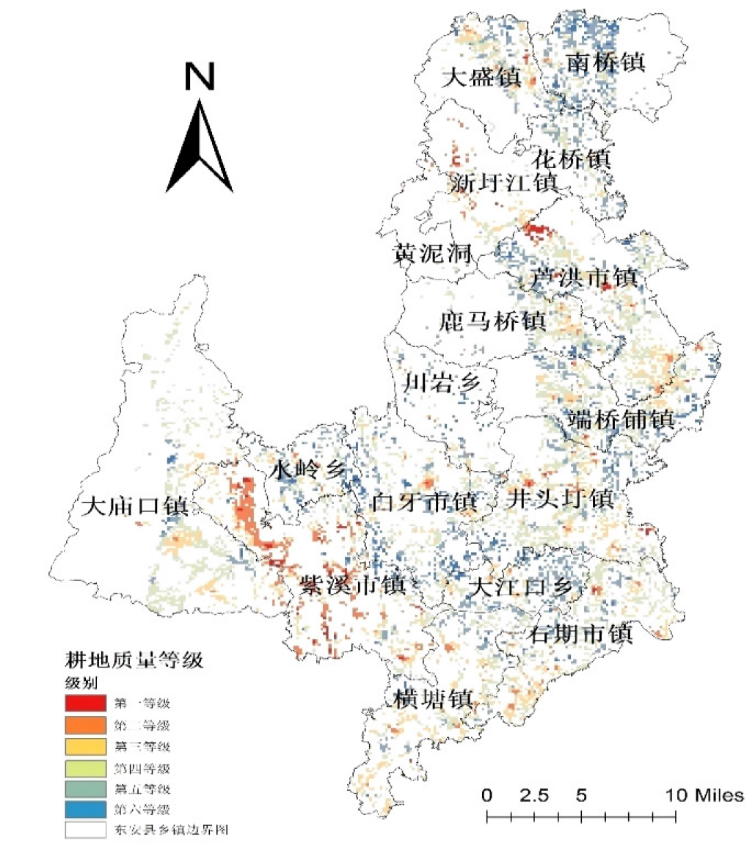
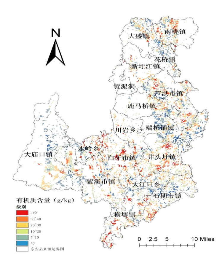
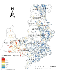
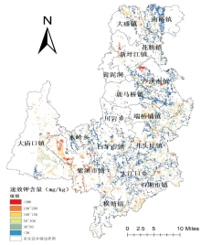
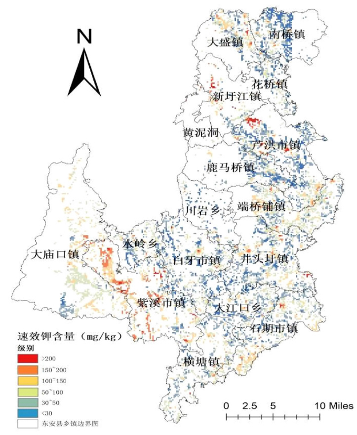
耕地是粮食生产的基础,耕地质量高低影响耕地综合生产能力。中央和地方政府多次指出要保护耕地红线,粮食生产要稳政策、稳面积、稳产量。湘江流域山地丘陵区面积分布广泛,研究山地丘陵地区的耕地质量水平对深化流域内山地丘陵区保护耕地、提升耕地地力具有重要意义。选取湘江上游流域内典型的山地丘陵区东安县耕地进行质量评价,在ArcGIS平台将东安县的土壤图、土地利用现状图、行政区划图叠加进行分析,采用层次分析法确定指标权重,模糊数学确定隶属度后综合权重求出结果。结果表明:根据《耕地质量等级》GB/T 33469—2016评价标准,评价结果为:东安县耕地质量分为6个等级。其中,三等地的面积为12793 hm2,占总面积的比例最高,为37.4%;其次是二等地和四等地的面积分布较广,分别是8648、6985 hm2,所占比例为25.3%、20.4%;其他等级土地面积相对较少。东安县耕地有效磷、速效钾、有机质的含量多地偏于中等水平,土壤养分特征多为一级、二级、三级的耕地面积分布较广,需要有针对性的采取一些提升耕地生产能力的措施。
李晓青, 吴琳, 何长元. 基于AHP和GIS的湘江上游山地丘陵区耕地质量水平研究——以东安县为例[J]. 中国农学通报, 2023, 39(23): 30-38.
LI Xiaoqing, WU Lin, HE Changyuan. Study on Cultivated Land Quality Level in the Upper Reaches of Xiangjiang River Hilly Region based on AHP and GIS: Take Dong’an County as an Example[J]. Chinese Agricultural Science Bulletin, 2023, 39(23): 30-38.


| 标度 | 含义 |
|---|---|
| 1 | 两个因素相比重要性相当 |
| 3 | 因素Ym与Yn相比,其中一个略显重要 |
| 5 | 因素Ym与Yn相比,其中一个明显重要 |
| 7 | 因素Ym与Yn相比,其中一个强烈重要 |
| 9 | 因素Ym与Yn相比,其中一个绝对重要 |
| 1~9 | 取该数值相邻判断中间的某一值 |
| 倒数 | 若因素Ym与Yn的重要性之比为Ymn, 则因素Yn与Ym的关系是Ymn=1/Ynm |
| 标度 | 含义 |
|---|---|
| 1 | 两个因素相比重要性相当 |
| 3 | 因素Ym与Yn相比,其中一个略显重要 |
| 5 | 因素Ym与Yn相比,其中一个明显重要 |
| 7 | 因素Ym与Yn相比,其中一个强烈重要 |
| 9 | 因素Ym与Yn相比,其中一个绝对重要 |
| 1~9 | 取该数值相邻判断中间的某一值 |
| 倒数 | 若因素Ym与Yn的重要性之比为Ymn, 则因素Yn与Ym的关系是Ymn=1/Ynm |
| 指标 | 健康状况A | 剖面性状B | 立地条件C | 理化性状D | 农田管理E | 土壤养分F | 组合权重(相乘) |
|---|---|---|---|---|---|---|---|
| 0.0686 | 0.149 | 0.1728 | 0.1851 | 0.2022 | 0.2223 | ||
| 清洁程度A1 | 0.4065 | 0.14034 | |||||
| 生物多样性A2 | 0.5935 | 0.13766 | |||||
| 障碍因素A3 | 0.2874 | 0.10795 | |||||
| 有效土层厚度B1 | 0.3509 | 0.07557 | |||||
| 质地构型B2 | 0.3617 | 0.06603 | |||||
| 农田林网化C1 | 0.1876 | 0.06477 | |||||
| 地形部位C2 | 0.8124 | 0.05725 | |||||
| 容重D1 | 0.2359 | 0.05676 | |||||
| 耕层质地D2 | 0.3568 | 0.05393 | |||||
| 土壤pH D3 | 0.4074 | 0.05229 | |||||
| 排水能力E1 | 0.3195 | 0.04379 | |||||
| 灌溉能力E2 | 0.6805 | 0.04273 | |||||
| 速效钾F1 | 0.2557 | 0.04072 | |||||
| 有效磷F2 | 0.2578 | 0.03239 | |||||
| 有机质F3 | 0.4865 | 0.02783 |
| 评价指标 | 函数类型 | 公式 | a1 | ui1 | ui2 | ci |
|---|---|---|---|---|---|---|
| 有效土层厚度 | 戒上型 | Y=1/[1+a1(ui-ci)2] | 0.000205 | 10 | 无 | 99.092342 |
| 有机质 | 戒上型 | Y=1/[1+a1(ui-ci)2] | 0.001842 | 0 | 无 | 33.656446 |
| 有效磷 | 戒上型 | Y=1/[1+a1(ui-ci)2] | 0.002025 | 0 | 无 | 33.346824 |
| 速效钾 | 戒上型 | Y=1/[1+a1(ui-ci)2] | 0.000081 | 5 | 无 | 181.62535 |
| pH | 峰型 | Y=1/[1+a1(ui-ci)2] | 0.221129 | 3 | 10 | 6.811204 |
| 容重 | 峰型 | Y=1/[1+a1(ui-ci)2] | 2.236726 | 0.5 | 3.21 | 1.211674 |
| 评价指标 | 函数类型 | 条件 | 隶属度Wi |
|---|---|---|---|
| 地形部位 | 概念型 | 平原低阶 | 1 |
| 款谷盆地 | 0.95 | ||
| 平原中阶 | 0.95 | ||
| 平原高阶 | 0.9 | ||
| 山间盆地 | 0.8 | ||
| 丘陵下部 | 0.8 | ||
| 丘陵中部 | 0.7 | ||
| 山地坡下 | 0.68 | ||
| 丘陵上部 | 0.6 | ||
| 山地坡中 | 0.45 | ||
| 山地坡上 | 0.3 | ||
| 土壤质地 | 概念型 | 中壤 | 1 |
| 重壤 | 0.95 | ||
| 轻壤 | 0.9 | ||
| 砂壤 | 0.85 | ||
| 黏土 | 0.7 | ||
| 砂土 | 0.6 | ||
| 排水能力 | 概念型 | 充分满足 | 1 |
| 满足 | 0.8 | ||
| 基本满足 | 0.6 | ||
| 不满足 | 0.3 | ||
| 清洁程度 | 概念型 | 清洁 | 1 |
| 尚清洁 | 0.8 | ||
| 质地构型 | 概念型 | 上松下紧型 | 1 |
| 海绵型 | 0.95 | ||
| 夹层型 | 0.85 | ||
| 紧实型 | 0.75 | ||
| 薄层型 | 0.55 | ||
| 下紧上松型 | 0.4 | ||
| 松散型 | 0.3 | ||
| 障碍因素 | 概念型 | 无 | 1 |
| 酸化 | 0.7 | ||
| 瘠薄 | 0.65 | ||
| 障碍层次 | 0.6 | ||
| 渍潜 | 0.55 | ||
| 盐碱 | 0.5 |
| 耕地等级 | 耕地地力指数Q |
|---|---|
| 一等地 | Q≥0.9170 |
| 二等地 | 0.8924≤Q<0.9170 |
| 三等地 | 0.8678≤Q<0.8924 |
| 四等地 | 0.8431≤Q<0.8678 |
| 五等地 | 0.8185≤Q<0.8431 |
| 六等地 | 0.7939≤Q<0.8185 |
| 七等地 | 0.7693≤Q<0.7939 |
| 八等地 | 0.7466≤Q<0.7693 |
| 九等地 | 0.7200≤Q<0.7466 |
| 十等地 | Q≤0.7200 |
| 耕地等级 | 耕地地力指数Q |
|---|---|
| 一等地 | Q≥0.9170 |
| 二等地 | 0.8924≤Q<0.9170 |
| 三等地 | 0.8678≤Q<0.8924 |
| 四等地 | 0.8431≤Q<0.8678 |
| 五等地 | 0.8185≤Q<0.8431 |
| 六等地 | 0.7939≤Q<0.8185 |
| 七等地 | 0.7693≤Q<0.7939 |
| 八等地 | 0.7466≤Q<0.7693 |
| 九等地 | 0.7200≤Q<0.7466 |
| 十等地 | Q≤0.7200 |


| 镇名 | 单位 | 一等地 | 二等地 | 三等地 | 四等地 | 五等地 | 六等地 | 合计 | |||||||||||
|---|---|---|---|---|---|---|---|---|---|---|---|---|---|---|---|---|---|---|---|
| 黄泥洞 | 面积/hm2 | 0.00 | 14.85 | 22.27 | 25.98 | 22.27 | 0.00 | 85.36 | |||||||||||
| 比例/% | 0 | 17 | 26 | 30 | 26 | 0 | 100 | ||||||||||||
| 白牙市镇 | 面积/hm2 | 415.67 | 890.72 | 994.64 | 475.05 | 100.21 | 7.42 | 2883.71 | |||||||||||
| 比例/% | 14 | 31 | 34 | 16 | 3 | 0 | 100 | ||||||||||||
| 井头圩镇 | 面积/hm2 | 181.86 | 827.63 | 1529.07 | 827.63 | 185.57 | 37.11 | 3588.87 | |||||||||||
| 比例/% | 5 | 23 | 43 | 23 | 5 | 1 | 100 | ||||||||||||
| 川言乡 | 面积/hm2 | 133.61 | 226.39 | 204.12 | 51.96 | 29.69 | 0.00 | 645.77 | |||||||||||
| 比例/% | 21 | 35 | 32 | 8 | 5 | 0 | 100 | ||||||||||||
| 芦洪市镇 | 面积/hm2 | 170.72 | 805.36 | 1547.63 | 749.69 | 155.88 | 152.16 | 3581.44 | |||||||||||
| 比例/% | 5 | 22 | 43 | 21 | 4 | 4 | 100 | ||||||||||||
| 大江口乡 | 面积/hm2 | 148.45 | 701.44 | 274.64 | 155.88 | 22.27 | 0.00 | 1302.68 | |||||||||||
| 比例/% | 11 | 54 | 21 | 12 | 2 | 0 | 100 | ||||||||||||
| 鹿马桥镇 | 面积/hm2 | 74.23 | 430.52 | 823.92 | 178.14 | 44.54 | 3.71 | 1555.05 | |||||||||||
| 比例/% | 5 | 28 | 53 | 11 | 3 | 0 | 100 | ||||||||||||
| 大庙口 | 面积/hm2 | 63.09 | 270.93 | 1859.38 | 753.40 | 148.45 | 11.13 | 3106.39 | |||||||||||
| 比例/% | 2 | 9 | 60 | 24 | 5 | 0 | 100 | ||||||||||||
| 南桥镇 | 面积/hm2 | 341.44 | 1091.13 | 367.42 | 81.65 | 18.56 | 0.00 | 1900.21 | |||||||||||
| 比例/% | 18 | 57 | 19 | 4 | 1 | 0 | 100 | ||||||||||||
| 大盛镇 | 面积/hm2 | 66.80 | 504.74 | 638.35 | 341.44 | 89.07 | 14.85 | 1655.26 | |||||||||||
| 比例/% | 4 | 30 | 39 | 21 | 5 | 1 | 100 | ||||||||||||
| 石期镇 | 面积/hm2 | 74.23 | 463.92 | 1217.32 | 734.85 | 167.01 | 14.85 | 2672.16 | |||||||||||
| 比例/% | 3 | 17 | 46 | 28 | 6 | 1 | 100 | ||||||||||||
| 水岭乡 | 面积/hm2 | 152.16 | 449.07 | 289.48 | 170.72 | 51.96 | 0.00 | 1113.40 | |||||||||||
| 比例/% | 14% | 40% | 26% | 15% | 5% | 0% | 100% | ||||||||||||
| 端桥铺 | 面积/hm2 | 218.97 | 745.98 | 1131.96 | 504.74 | 89.07 | 11.13 | 2701.86 | |||||||||||
| 比例/% | 8% | 28% | 42% | 19% | 3% | 0% | 100% | ||||||||||||
| 花桥镇 | 面积/hm2 | 37.11 | 463.92 | 326.60 | 74.23 | 7.42 | 0.00 | 909.28 | |||||||||||
| 比例/% | 4% | 51% | 36% | 8% | 1% | 0% | 100% | ||||||||||||
| 横塘镇 | 面积/hm2 | 40.82 | 430.52 | 835.05 | 835.05 | 115.05 | 3.71 | 2260.21 | |||||||||||
| 比例/% | 2% | 19% | 37% | 37% | 5% | 0% | 100% | ||||||||||||
| 新圩江 | 面积/hm2 | 3.71 | 55.67 | 163.30 | 267.22 | 163.30 | 40.82 | 694.02 | |||||||||||
| 比例/% | 1% | 8% | 24% | 39% | 24% | 6% | 100% | ||||||||||||
| 紫溪市 | 面积/hm2 | 122.47 | 274.64 | 567.84 | 757.11 | 1562.47 | 259.79 | 3544.33 | |||||||||||
| 比例/% | 3% | 8% | 16% | 21% | 44% | 7% | 100% | ||||||||||||


| [1] |
李萍, 王军. 中国耕地质量保护与提升:一个历史演进的视角——纪念改革开放40周年暨新中国成立70周年[C]. 全国高校社会主义经济理论与实践研讨会领导小组.社会主义经济理论研究集萃(2018):高质量发展的中国经济. 全国高校社会主义经济理论与实践研讨会领导小组: 中国人民大学中国经济改革与发展研究院, 2018:250-265.
|
| [2] |
董利民, 万磊, 王雅鹏. 试论我国农地资源的稀缺性与土地整理的必要性[C]. 2006年和谐社会与新农村发展国际学术研讨会, 2006:64-71.
|
| [3] |
张敏. 耕地质量评价方法研究概述[J]. 农村经济与科技, 2020, 31(21):10-12.
|
| [4] |
朱瑕, 张立亭, 靳焕焕. 基于因素法和SVM模型的耕地质量评价方法研究[J]. 土壤通报, 2020, 51(3):561-567.
|
| [5] |
唐宗, 周悟, 杨颢, 等. 基于交互效应Logistic回归模型的耕地质量评价方法研究[J]. 生态环境学报, 2020, 29(12):2394-2403.
doi: 10.16258/j.cnki.1674-5906.2020.012.010 |
| [6] |
何新莹, 聂艳, 王朴, 等. 基于改进灰靶模型的耕地质量评价方法与实证[J]. 土壤学报:1-11.
|
| [7] |
杨君, 邵劲松, 周鹏全, 等. 基于地块尺度的耕地质量级别变化及农业空间保护——以岳阳市岳阳楼区为例[J]. 经济地理, 2021, 41(11):185-192.
|
| [8] |
王丽, 周勇, 李晴, 等. 基于随机森林的耕地质量评价智能模型及其应用研究[J]. 土壤学报, 2022, 59(5):1279-1292.
|
| [9] |
张新乐, 钱蕾, 鲍依临, 等. 黑土区田块尺度耕地质量遥感监测与评价[J]. 土壤通报, 2020, 51(6):1303-1312.
|
| [10] |
陈文广, 孔祥斌, 廖宇波, 等. 黄土高原区耕地质量评价——以陕西省延川县为例[J]. 水土保持研究, 2021, 28(2):375-381.
|
| [11] |
徐雪生, 骆检兰, 黄逢秋, 等. 富硒耕地质量评价体系构建及其在湖南省新田县新圩镇的应用[J]. 中国地质, 2022, 49(3):789-801.
|
| [12] |
于美荣. 2019年天津市耕地质量监测评价结果分析[J]. 天津农林科技, 2021(4):37-39.
|
| [13] |
龙晓辉. 基于3S技术的东安县耕地土壤肥力特征及其分级评价[D]. 长沙: 湖南农业大学, 2010.
|
| [14] |
赵赛男. 长沙市耕地质量评价[D]. 长沙: 湖南农业大学, 2019.
|
| [15] |
中华人民共和国农业农村部. GB/T 33469—2016,《耕地质量等级》[S]. 中国国家标准化管理委员会, 2016.
|
| [16] |
胡建军. 东安县粮食高产创建技术的推广[J]. 作物研究, 2015, 29(1):67-68,76.
|
| [17] |
赵建军, 张洪岩, 王野乔, 等. 基于AHP和GIS的省级耕地质量评价研究——以吉林省为例[J]. 土壤通报, 2012, 43(1):70-75.
|
| [18] |
方琳娜, 宋金平. 基于SPOT多光谱影像的耕地质量评价——以山东省即墨市为例[J]. 地理科学进展, 2008(5):71-78.
doi: 10.11820/dlkxjz.2008.05.010 |
| [19] |
曹胜, 周卫军, 王凡荣, 等. 东安县水稻测土配方施肥专家信息系统研制与推广示范[J]. 农业网络信息, 2015(9):66-71.
|
| [20] |
刘鹏. 孙吴县耕地质量评价[D]. 哈尔滨: 东北农业大学, 2020.
|
| [21] |
张苹. 富锦市耕地质量评价[D]. 哈尔滨: 东北农业大学, 2018.
|
| [22] |
孙晓兵, 孔祥斌, 温良友. 基于耕地要素的耕地质量评价指标体系研究及其发展趋势[J]. 土壤通报, 2019, 50(3):739-747.
|
| [23] |
曹新竹. 下辽河平原区耕地质量等别评价及提升潜力研究[D]. 沈阳: 沈阳农业大学, 2019.
|
| [24] |
范佳旭, 汤江龙. 耕地质量相关研究综述[J]. 住宅与房地产, 2019(18):248-250.
|
| [25] |
许树柏. 实用决策方法:层次分析法原理[M]. 天津: 天津大学出版社, 1988.
|
| [26] |
程晋南, 赵庚星, 张子雪, 等. 基于GIS的小尺度耕地质量综合评价研究——以山东省丁庄镇为例[J]. 自然资源学报, 2009, 24(3):536-544.
doi: 10.11849/zrzyxb.2009.03.019 |
| [1] | 李斐然, 王永奇. 林麝分布区可饲用野生植物叶营养价值综合评价方法的探索[J]. 中国农学通报, 2023, 39(8): 119-126. |
| [2] | 张秋露. 基于层次分析法的京杭运河(淮安段)外引彩叶树种综合评价[J]. 中国农学通报, 2023, 39(8): 15-20. |
| [3] | 廖河庭, 郑尧, 王宁, 安树伟, 顾玲玲, 陈家长. 苏北不同地区藕虾种养模式浮游生物群落结构特征分析[J]. 中国农学通报, 2023, 39(8): 156-164. |
| [4] | 李大鹏, 张宝鑫, 李跃超. 园林景观树木健康状况评价与分析——以中国园林博物馆室外展园油松为例[J]. 中国农学通报, 2023, 39(4): 14-22. |
| [5] | 刘媛媛, 涂国良. 平凉市耕地土壤有效态微量元素丰缺评价及影响因素研究[J]. 中国农学通报, 2023, 39(4): 83-92. |
| [6] | 关体坤, 刘子璐, 李小玉, 王建立, 侯霜影, 刘栩杉, 徐诗毅, 陈青君, 张国庆. 工厂化杏鲍菇菌渣生物炭制备及质量评价[J]. 中国农学通报, 2023, 39(3): 71-79. |
| [7] | 王永丽, 徐新泉, 张建国. 基于SBE法的湖州市长岛公园植物景观美景度评价[J]. 中国农学通报, 2023, 39(25): 69-76. |
| [8] | 李佳欣, 盖伟玲, 孙显旻, 赵昕, 张晓光, 崔德杰. 基于GIS的土壤养分空间分布特征及肥力评价[J]. 中国农学通报, 2023, 39(25): 94-101. |
| [9] | 叶佩, 刘志雄, 刘凯文, 刘可群. 小龙虾气候品质评价技术与应用[J]. 中国农学通报, 2023, 39(24): 149-156. |
| [10] | 李斐然, 王永奇. 圈养林麝饲用植物叶主要矿物元素含量特征与综合分析[J]. 中国农学通报, 2023, 39(24): 157-164. |
| [11] | 蔡勋, 梁俊芬, 冯珊珊, 周灿芳. 佛山市都市现代农业多功能发展评价及对策研究[J]. 中国农学通报, 2023, 39(23): 145-152. |
| [12] | 袁文彬, 黄浩, 关罗浩, 李超, 王文辉, 谢丹凤, 杨天旭, 王维. 会理烟区烤烟质量特征的区域归类研究[J]. 中国农学通报, 2023, 39(22): 96-103. |
| [13] | 李如美, 刘同金, 梁慧, 冯义志, 梁林, 李瑞娟, 于建垒. 液相色谱-串联质谱法分析噻虫嗪在菜薹上的残留行为[J]. 中国农学通报, 2023, 39(20): 133-137. |
| [14] | 姜冰, 王松涛, 孙增兵, 张海瑞, 王建, 刘阳. 基于隶属度函数和主成分分析的耕地土壤肥力评价[J]. 中国农学通报, 2023, 39(2): 22-27. |
| [15] | 梁焕, 安岳. 不同主产区小茴香药材质量评价[J]. 中国农学通报, 2023, 39(19): 148-152. |
| 阅读次数 | ||||||
|
全文 |
|
|||||
|
摘要 |
|
|||||